IMO 9292199
Vessel information
Sanction Status
⚠️ This vessel is sanctioned.
Detected Events (100)
- Minimum Distance: 41 meters
- Average Distance: 47 meters
- Duration: 33 minutes
- Period: 2026-06-09T09:01:48+00:00 to 2026-06-09T09:34:48+00:00
- Vessel A Avg Speed: 0.0 knots
- Vessel B Avg Speed: 0.0 knots
- Zone: Bosphorus/Dardanelles Approach
Confidence Analysis
Moderate-confidence STS candidate. Two tankers (ALTURA and VELORA) maintained close proximity (min 41m, avg 47m) for 33 minutes. Both vessels were slow-moving (avg speeds 0.0 and 0.0 knots). The stable separation distance suggests deliberate parallel positioning typical of cargo transfer. Event occurred in Bosphorus/Dardanelles Approach, a known STS activity area.
View scoring breakdown
| Factor | Score | Detail |
|---|---|---|
| Distance Tightness | 25/25 | Min distance 41m, avg 47m |
| Duration | 5/25 | Duration 33 minutes |
| Speed Stability | 20/20 | both nearly stationary; very stable speeds |
| Distance Consistency | 15/15 | Distance variance ±3m |
| Isolation | 5/10 | Isolation data not available |
| Context | 5/5 | In monitored zone: Bosphorus/Dardanelles Approach |
🛰️ Satellite Corroboration
Satellite imagery search queued
Show Raw Evidence JSON
{
    "vessel_a": {
        "mmsi": 667001275,
        "imo": 9292199,
        "name": "ALTURA",
        "flag": "Sierra Leone"
    },
    "vessel_b": {
        "mmsi": 667001274,
        "imo": 9290373,
        "name": "VELORA",
        "flag": "Sierra Leone"
    },
    "min_distance_m": 40.89999999999999857891452847979962825775146484375,
    "avg_distance_m": 47.10000000000000142108547152020037174224853515625,
    "distance_consistency_m": 3.399999999999999911182158029987476766109466552734375,
    "duration_minutes": 33,
    "overlap_duration_s": 1980,
    "speed_a_avg": 0,
    "speed_a_std": 0,
    "speed_b_avg": 0,
    "speed_b_std": 0,
    "speed_summary": {
        "vessel_a": {
            "avg_sog": 0,
            "max_sog": 0
        },
        "vessel_b": {
            "avg_sog": 0,
            "max_sog": 0
        }
    },
    "time_window": {
        "start": "2026-06-09T09:01:48+00:00",
        "end": "2026-06-09T09:34:48+00:00"
    },
    "points_count": {
        "vessel_a": 11,
        "vessel_b": 11
    },
    "zone_id": "osint_bosphorus",
    "zone_name": "Bosphorus\/Dardanelles Approach",
    "score": {
        "value": 75,
        "components": {
            "distance_tightness": {
                "score": 25,
                "max": 25,
                "detail": "Min distance 41m, avg 47m"
            },
            "duration": {
                "score": 5,
                "max": 25,
                "detail": "Duration 33 minutes"
            },
            "speed_stability": {
                "score": 20,
                "max": 20,
                "detail": "both nearly stationary; very stable speeds"
            },
            "distance_consistency": {
                "score": 15,
                "max": 15,
                "detail": "Distance variance \u00b13m"
            },
            "isolation": {
                "score": 5,
                "max": 10,
                "detail": "Isolation data not available"
            },
            "context": {
                "score": 5,
                "max": 5,
                "detail": "In monitored zone: Bosphorus\/Dardanelles Approach"
            }
        },
        "summary": "Moderate-confidence STS candidate. Two tankers (ALTURA and VELORA) maintained close proximity (min 41m, avg 47m) for 33 minutes. Both vessels were slow-moving (avg speeds 0.0 and 0.0 knots). The stable separation distance suggests deliberate parallel positioning typical of cargo transfer. Event occurred in Bosphorus\/Dardanelles Approach, a known STS activity area."
    },
    "sar": {
        "status": "pending"
    }
}- Minimum Distance: 28 meters
- Average Distance: 56 meters
- Duration: 58 minutes
- Period: 2026-06-09T05:31:38+00:00 to 2026-06-09T06:29:58+00:00
- Vessel A Avg Speed: 0.2 knots
- Vessel B Avg Speed: 0.1 knots
- Zone: Bosphorus/Dardanelles Approach
Confidence Analysis
High-confidence STS candidate. Two tankers (ALTURA and VELORA) maintained close proximity (min 28m, avg 56m) for 58 minutes. Both vessels were slow-moving (avg speeds 0.2 and 0.1 knots). The stable separation distance suggests deliberate parallel positioning typical of cargo transfer. Event occurred in Bosphorus/Dardanelles Approach, a known STS activity area.
View scoring breakdown
| Factor | Score | Detail |
|---|---|---|
| Distance Tightness | 25/25 | Min distance 28m, avg 56m |
| Duration | 10/25 | Duration 58 minutes |
| Speed Stability | 20/20 | both nearly stationary; very stable speeds |
| Distance Consistency | 15/15 | Distance variance ±21m |
| Isolation | 5/10 | Isolation data not available |
| Context | 5/5 | In monitored zone: Bosphorus/Dardanelles Approach |
Show Raw Evidence JSON
{
    "vessel_a": {
        "mmsi": 667001275,
        "imo": 9292199,
        "name": "ALTURA",
        "flag": "Sierra Leone"
    },
    "vessel_b": {
        "mmsi": 667001274,
        "imo": 9290373,
        "name": "VELORA",
        "flag": "Sierra Leone"
    },
    "min_distance_m": 27.60000000000000142108547152020037174224853515625,
    "avg_distance_m": 55.60000000000000142108547152020037174224853515625,
    "distance_consistency_m": 21.39999999999999857891452847979962825775146484375,
    "duration_minutes": 58.2999999999999971578290569595992565155029296875,
    "overlap_duration_s": 3500,
    "speed_a_avg": 0.1700000000000000122124532708767219446599483489990234375,
    "speed_a_std": 0.08000000000000000166533453693773481063544750213623046875,
    "speed_b_avg": 0.1000000000000000055511151231257827021181583404541015625,
    "speed_b_std": 0.08000000000000000166533453693773481063544750213623046875,
    "speed_summary": {
        "vessel_a": {
            "avg_sog": 0.1700000000000000122124532708767219446599483489990234375,
            "max_sog": 0.299999999999999988897769753748434595763683319091796875
        },
        "vessel_b": {
            "avg_sog": 0.1000000000000000055511151231257827021181583404541015625,
            "max_sog": 0.200000000000000011102230246251565404236316680908203125
        }
    },
    "time_window": {
        "start": "2026-06-09T05:31:38+00:00",
        "end": "2026-06-09T06:29:58+00:00"
    },
    "points_count": {
        "vessel_a": 21,
        "vessel_b": 21
    },
    "zone_id": "osint_bosphorus",
    "zone_name": "Bosphorus\/Dardanelles Approach",
    "score": {
        "value": 80,
        "components": {
            "distance_tightness": {
                "score": 25,
                "max": 25,
                "detail": "Min distance 28m, avg 56m"
            },
            "duration": {
                "score": 10,
                "max": 25,
                "detail": "Duration 58 minutes"
            },
            "speed_stability": {
                "score": 20,
                "max": 20,
                "detail": "both nearly stationary; very stable speeds"
            },
            "distance_consistency": {
                "score": 15,
                "max": 15,
                "detail": "Distance variance \u00b121m"
            },
            "isolation": {
                "score": 5,
                "max": 10,
                "detail": "Isolation data not available"
            },
            "context": {
                "score": 5,
                "max": 5,
                "detail": "In monitored zone: Bosphorus\/Dardanelles Approach"
            }
        },
        "summary": "High-confidence STS candidate. Two tankers (ALTURA and VELORA) maintained close proximity (min 28m, avg 56m) for 58 minutes. Both vessels were slow-moving (avg speeds 0.2 and 0.1 knots). The stable separation distance suggests deliberate parallel positioning typical of cargo transfer. Event occurred in Bosphorus\/Dardanelles Approach, a known STS activity area."
    }
}- Minimum Distance: 42 meters
- Average Distance: 49 meters
- Duration: 2h 33m
- Period: 2026-06-09T04:16:38+00:00 to 2026-06-09T06:49:50+00:00
- Vessel A Avg Speed: 0.1 knots
- Vessel B Avg Speed: 0.1 knots
- Zone: Bosphorus/Dardanelles Approach
Confidence Analysis
High-confidence STS candidate. Two tankers (VELORA and ALTURA) maintained close proximity (min 42m, avg 49m) for 153 minutes. Both vessels were slow-moving (avg speeds 0.1 and 0.1 knots). The stable separation distance suggests deliberate parallel positioning typical of cargo transfer. Event occurred in Bosphorus/Dardanelles Approach, a known STS activity area.
View scoring breakdown
| Factor | Score | Detail |
|---|---|---|
| Distance Tightness | 25/25 | Min distance 42m, avg 49m |
| Duration | 25/25 | Duration 153 minutes |
| Speed Stability | 20/20 | both nearly stationary; very stable speeds |
| Distance Consistency | 15/15 | Distance variance ±4m |
| Isolation | 5/10 | Isolation data not available |
| Context | 5/5 | In monitored zone: Bosphorus/Dardanelles Approach |
Show Raw Evidence JSON
{
    "vessel_a": {
        "mmsi": 667001274,
        "imo": 9290373,
        "name": "VELORA",
        "flag": "Sierra Leone"
    },
    "vessel_b": {
        "mmsi": 667001275,
        "imo": 9292199,
        "name": "ALTURA",
        "flag": "Sierra Leone"
    },
    "min_distance_m": 41.7000000000000028421709430404007434844970703125,
    "avg_distance_m": 48.7000000000000028421709430404007434844970703125,
    "distance_consistency_m": 4.5,
    "duration_minutes": 153.19999999999998863131622783839702606201171875,
    "overlap_duration_s": 9192,
    "speed_a_avg": 0.059999999999999997779553950749686919152736663818359375,
    "speed_a_std": 0.08000000000000000166533453693773481063544750213623046875,
    "speed_b_avg": 0.11999999999999999555910790149937383830547332763671875,
    "speed_b_std": 0.070000000000000006661338147750939242541790008544921875,
    "speed_summary": {
        "vessel_a": {
            "avg_sog": 0.059999999999999997779553950749686919152736663818359375,
            "max_sog": 0.200000000000000011102230246251565404236316680908203125
        },
        "vessel_b": {
            "avg_sog": 0.11999999999999999555910790149937383830547332763671875,
            "max_sog": 0.299999999999999988897769753748434595763683319091796875
        }
    },
    "time_window": {
        "start": "2026-06-09T04:16:38+00:00",
        "end": "2026-06-09T06:49:50+00:00"
    },
    "points_count": {
        "vessel_a": 12,
        "vessel_b": 12
    },
    "zone_id": "osint_bosphorus",
    "zone_name": "Bosphorus\/Dardanelles Approach",
    "score": {
        "value": 95,
        "components": {
            "distance_tightness": {
                "score": 25,
                "max": 25,
                "detail": "Min distance 42m, avg 49m"
            },
            "duration": {
                "score": 25,
                "max": 25,
                "detail": "Duration 153 minutes"
            },
            "speed_stability": {
                "score": 20,
                "max": 20,
                "detail": "both nearly stationary; very stable speeds"
            },
            "distance_consistency": {
                "score": 15,
                "max": 15,
                "detail": "Distance variance \u00b14m"
            },
            "isolation": {
                "score": 5,
                "max": 10,
                "detail": "Isolation data not available"
            },
            "context": {
                "score": 5,
                "max": 5,
                "detail": "In monitored zone: Bosphorus\/Dardanelles Approach"
            }
        },
        "summary": "High-confidence STS candidate. Two tankers (VELORA and ALTURA) maintained close proximity (min 42m, avg 49m) for 153 minutes. Both vessels were slow-moving (avg speeds 0.1 and 0.1 knots). The stable separation distance suggests deliberate parallel positioning typical of cargo transfer. Event occurred in Bosphorus\/Dardanelles Approach, a known STS activity area."
    }
}- Zone: Bosphorus/Dardanelles Approach
- Duration: 6h 2m
- Data Points: 106 AIS positions
- Period: 2026-06-09T03:32:28+00:00 to 2026-06-09T09:34:48+00:00
Show Raw Evidence JSON
{
    "zone_id": "osint_bosphorus",
    "zone_name": "Bosphorus\/Dardanelles Approach",
    "dwell_minutes": 362.30000000000001136868377216160297393798828125,
    "points_in_zone": 106,
    "first_point": {
        "ts": "2026-06-09T03:32:28+00:00",
        "lat": 41.466059999999998808561940677464008331298828125,
        "lon": 28.713011699999999137844497454352676868438720703125
    },
    "last_point": {
        "ts": "2026-06-09T09:34:48+00:00",
        "lat": 41.46201169999999791571099194698035717010498046875,
        "lon": 28.710833300000000889440343598835170269012451171875
    }
}- Duration: 6h 2m
- Radius: 385 meters
- Data Points: 106 AIS positions
- Centroid: 41.4628, 28.7115
- Zone: Bosphorus/Dardanelles Approach
Show Raw Evidence JSON
{
    "radius_m": 385.1000000000000227373675443232059478759765625,
    "duration_minutes": 362.30000000000001136868377216160297393798828125,
    "points": 106,
    "centroid": {
        "lat": 41.46277790849058675348715041764080524444580078125,
        "lon": 28.711523179245290293692960403859615325927734375
    },
    "bbox": {
        "min_lat": 41.46116829999999708888935856521129608154296875,
        "min_lon": 28.7104183000000006131813279353082180023193359375,
        "max_lat": 41.466059999999998808561940677464008331298828125,
        "max_lon": 28.713011699999999137844497454352676868438720703125
    },
    "zone_id": "osint_bosphorus"
}- Zone: Bosphorus/Dardanelles Approach
- Duration: 6h 35m
- Data Points: 106 AIS positions
- Period: 2026-06-09T02:53:47+00:00 to 2026-06-09T09:29:39+00:00
Show Raw Evidence JSON
{
    "zone_id": "osint_bosphorus",
    "zone_name": "Bosphorus\/Dardanelles Approach",
    "dwell_minutes": 395.8999999999999772626324556767940521240234375,
    "points_in_zone": 106,
    "first_point": {
        "ts": "2026-06-09T02:53:47+00:00",
        "lat": 41.46622500000000144382283906452357769012451171875,
        "lon": 28.71327169999999995297912391833961009979248046875
    },
    "last_point": {
        "ts": "2026-06-09T09:29:39+00:00",
        "lat": 41.4620383000000032325260690413415431976318359375,
        "lon": 28.71084499999999906094672041945159435272216796875
    }
}- Duration: 6h 35m
- Radius: 400 meters
- Data Points: 106 AIS positions
- Centroid: 41.4629, 28.7116
- Zone: Bosphorus/Dardanelles Approach
Show Raw Evidence JSON
{
    "radius_m": 400.19999999999998863131622783839702606201171875,
    "duration_minutes": 395.8999999999999772626324556767940521240234375,
    "points": 106,
    "centroid": {
        "lat": 41.46285702735850264843975310213863849639892578125,
        "lon": 28.711569092452837281825850368477404117584228515625
    },
    "bbox": {
        "min_lat": 41.46116829999999708888935856521129608154296875,
        "min_lon": 28.7104183000000006131813279353082180023193359375,
        "max_lat": 41.46622500000000144382283906452357769012451171875,
        "max_lon": 28.71327169999999995297912391833961009979248046875
    },
    "zone_id": "osint_bosphorus"
}- Zone: Bosphorus/Dardanelles Approach
- Duration: 6h 32m
- Data Points: 107 AIS positions
- Period: 2026-06-09T01:55:48+00:00 to 2026-06-09T08:28:18+00:00
Show Raw Evidence JSON
{
    "zone_id": "osint_bosphorus",
    "zone_name": "Bosphorus\/Dardanelles Approach",
    "dwell_minutes": 392.5,
    "points_in_zone": 107,
    "first_point": {
        "ts": "2026-06-09T01:55:48+00:00",
        "lat": 41.46614670000000302252374240197241306304931640625,
        "lon": 28.713100000000000733280103304423391819000244140625
    },
    "last_point": {
        "ts": "2026-06-09T08:28:18+00:00",
        "lat": 41.4617999999999966576069709844887256622314453125,
        "lon": 28.71121670000000136724338517524302005767822265625
    }
}- Duration: 6h 32m
- Radius: 313 meters
- Data Points: 107 AIS positions
- Centroid: 41.4636, 28.7120
- Zone: Bosphorus/Dardanelles Approach
Show Raw Evidence JSON
{
    "radius_m": 312.6000000000000227373675443232059478759765625,
    "duration_minutes": 392.5,
    "points": 107,
    "centroid": {
        "lat": 41.463578070093461747092078439891338348388671875,
        "lon": 28.712000766355163960952268098480999469757080078125
    },
    "bbox": {
        "min_lat": 41.46116829999999708888935856521129608154296875,
        "min_lon": 28.7104183000000006131813279353082180023193359375,
        "max_lat": 41.46622500000000144382283906452357769012451171875,
        "max_lon": 28.71349500000000176669345819391310214996337890625
    },
    "zone_id": "osint_bosphorus"
}- Minimum Distance: 42 meters
- Average Distance: 49 meters
- Duration: 5h 57m
- Period: 2026-06-09T00:52:33+00:00 to 2026-06-09T06:49:50+00:00
- Vessel A Avg Speed: 0.1 knots
- Vessel B Avg Speed: 0.1 knots
- Zone: Bosphorus/Dardanelles Approach
Confidence Analysis
High-confidence STS candidate. Two tankers (VELORA and ALTURA) maintained close proximity (min 42m, avg 49m) for 357 minutes. Both vessels were slow-moving (avg speeds 0.1 and 0.1 knots). The stable separation distance suggests deliberate parallel positioning typical of cargo transfer. Event occurred in Bosphorus/Dardanelles Approach, a known STS activity area.
View scoring breakdown
| Factor | Score | Detail |
|---|---|---|
| Distance Tightness | 25/25 | Min distance 42m, avg 49m |
| Duration | 25/25 | Duration 357 minutes |
| Speed Stability | 20/20 | both nearly stationary; very stable speeds |
| Distance Consistency | 15/15 | Distance variance ±4m |
| Isolation | 5/10 | Isolation data not available |
| Context | 5/5 | In monitored zone: Bosphorus/Dardanelles Approach |
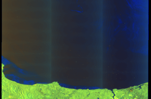
🛰️ Satellite Corroboration
Satellite imagery available but requires review
Preview available for manual review
Show Raw Evidence JSON
{
    "vessel_a": {
        "mmsi": 667001274,
        "imo": 9290373,
        "name": "VELORA",
        "flag": "Sierra Leone"
    },
    "vessel_b": {
        "mmsi": 667001275,
        "imo": 9292199,
        "name": "ALTURA",
        "flag": "Sierra Leone"
    },
    "min_distance_m": 41.7000000000000028421709430404007434844970703125,
    "avg_distance_m": 48.7000000000000028421709430404007434844970703125,
    "distance_consistency_m": 4.29999999999999982236431605997495353221893310546875,
    "duration_minutes": 357.30000000000001136868377216160297393798828125,
    "overlap_duration_s": 21437,
    "speed_a_avg": 0.059999999999999997779553950749686919152736663818359375,
    "speed_a_std": 0.08000000000000000166533453693773481063544750213623046875,
    "speed_b_avg": 0.11999999999999999555910790149937383830547332763671875,
    "speed_b_std": 0.070000000000000006661338147750939242541790008544921875,
    "speed_summary": {
        "vessel_a": {
            "avg_sog": 0.059999999999999997779553950749686919152736663818359375,
            "max_sog": 0.200000000000000011102230246251565404236316680908203125
        },
        "vessel_b": {
            "avg_sog": 0.11999999999999999555910790149937383830547332763671875,
            "max_sog": 0.299999999999999988897769753748434595763683319091796875
        }
    },
    "time_window": {
        "start": "2026-06-09T00:52:33+00:00",
        "end": "2026-06-09T06:49:50+00:00"
    },
    "points_count": {
        "vessel_a": 13,
        "vessel_b": 13
    },
    "zone_id": "osint_bosphorus",
    "zone_name": "Bosphorus\/Dardanelles Approach",
    "score": {
        "value": 95,
        "components": {
            "distance_tightness": {
                "score": 25,
                "max": 25,
                "detail": "Min distance 42m, avg 49m"
            },
            "duration": {
                "score": 25,
                "max": 25,
                "detail": "Duration 357 minutes"
            },
            "speed_stability": {
                "score": 20,
                "max": 20,
                "detail": "both nearly stationary; very stable speeds"
            },
            "distance_consistency": {
                "score": 15,
                "max": 15,
                "detail": "Distance variance \u00b14m"
            },
            "isolation": {
                "score": 5,
                "max": 10,
                "detail": "Isolation data not available"
            },
            "context": {
                "score": 5,
                "max": 5,
                "detail": "In monitored zone: Bosphorus\/Dardanelles Approach"
            }
        },
        "summary": "High-confidence STS candidate. Two tankers (VELORA and ALTURA) maintained close proximity (min 42m, avg 49m) for 357 minutes. Both vessels were slow-moving (avg speeds 0.1 and 0.1 knots). The stable separation distance suggests deliberate parallel positioning typical of cargo transfer. Event occurred in Bosphorus\/Dardanelles Approach, a known STS activity area."
    },
    "sar": {
        "status": "inconclusive",
        "centroid": {
            "lat": 41.46345939999999785641193739138543605804443359375,
            "lon": 28.7116079999999982419467414729297161102294921875
        },
        "time_window": {
            "start_ts": "2026-06-09T00:52:33+00:00",
            "end_ts": "2026-06-09T06:49:50+00:00"
        },
        "searched_at": "2026-06-09T08:00:07.374533+00:00",
        "scene_id": "S1D_IW_GRDH_1SDV_20260609T040522_20260609T040547_003154_0057B6_9317_COG",
        "scene_datetime": "2026-06-09T04:05:22.864988Z",
        "platform": "sentinel-1d",
        "bbox": {
            "min_lon": 28.295874000000001302623786614276468753814697265625,
            "min_lat": 40.7805790000000030204319045878946781158447265625,
            "max_lon": 31.7423399999999986675902619026601314544677734375,
            "max_lat": 42.6836890000000011013980838470160961151123046875
        },
        "assets": {
            "preview_url": "https:\/\/fleetleaks.com\/wp-content\/uploads\/fleetleaks-evidence\/sar-imagery\/2026\/06\/event_710432_thumbnail_20260609080011.png",
            "stored_path": "\/home\/fleetleaks\/public_html\/wp-content\/uploads\/fleetleaks-evidence\/sar-imagery\/2026\/06\/event_710432_thumbnail_20260609080011.png",
            "source": "copernicus_dataspace"
        },
        "notes": "Preview available for manual review"
    }
}- Zone: Bosphorus/Dardanelles Approach
- Duration: 6h 28m
- Data Points: 103 AIS positions
- Period: 2026-06-09T00:56:39+00:00 to 2026-06-09T07:25:28+00:00
Show Raw Evidence JSON
{
    "zone_id": "osint_bosphorus",
    "zone_name": "Bosphorus\/Dardanelles Approach",
    "dwell_minutes": 388.80000000000001136868377216160297393798828125,
    "points_in_zone": 103,
    "first_point": {
        "ts": "2026-06-09T00:56:39+00:00",
        "lat": 41.46591169999999948458935250528156757354736328125,
        "lon": 28.711569999999998259454514482058584690093994140625
    },
    "last_point": {
        "ts": "2026-06-09T07:25:28+00:00",
        "lat": 41.4612632999999988214767654426395893096923828125,
        "lon": 28.712006699999999881356416153721511363983154296875
    }
}- Duration: 6h 28m
- Radius: 340 meters
- Data Points: 103 AIS positions
- Centroid: 41.4642, 28.7121
- Zone: Bosphorus/Dardanelles Approach
Show Raw Evidence JSON
{
    "radius_m": 339.80000000000001136868377216160297393798828125,
    "duration_minutes": 388.80000000000001136868377216160297393798828125,
    "points": 103,
    "centroid": {
        "lat": 41.46422627961165829901801771484315395355224609375,
        "lon": 28.71209814077671040877248742617666721343994140625
    },
    "bbox": {
        "min_lat": 41.46116829999999708888935856521129608154296875,
        "min_lon": 28.7104183000000006131813279353082180023193359375,
        "max_lat": 41.46622500000000144382283906452357769012451171875,
        "max_lon": 28.71349500000000176669345819391310214996337890625
    },
    "zone_id": "osint_bosphorus"
}- Zone: Bosphorus/Dardanelles Approach
- Duration: 6h 37m
- Data Points: 95 AIS positions
- Period: 2026-06-08T23:21:10+00:00 to 2026-06-09T05:59:07+00:00
Show Raw Evidence JSON
{
    "zone_id": "osint_bosphorus",
    "zone_name": "Bosphorus\/Dardanelles Approach",
    "dwell_minutes": 397.8999999999999772626324556767940521240234375,
    "points_in_zone": 95,
    "first_point": {
        "ts": "2026-06-08T23:21:10+00:00",
        "lat": 41.4653382999999990943251759745180606842041015625,
        "lon": 28.710801700000001090984369511716067790985107421875
    },
    "last_point": {
        "ts": "2026-06-09T05:59:07+00:00",
        "lat": 41.4618932999999998401108314283192157745361328125,
        "lon": 28.710866700000000406589606427587568759918212890625
    }
}- Duration: 6h 37m
- Radius: 382 meters
- Data Points: 95 AIS positions
- Centroid: 41.4652, 28.7120
- Zone: Bosphorus/Dardanelles Approach
Show Raw Evidence JSON
{
    "radius_m": 381.69999999999998863131622783839702606201171875,
    "duration_minutes": 397.8999999999999772626324556767940521240234375,
    "points": 95,
    "centroid": {
        "lat": 41.46522454631581666717465850524604320526123046875,
        "lon": 28.711987933684202545236985315568745136260986328125
    },
    "bbox": {
        "min_lat": 41.4618932999999998401108314283192157745361328125,
        "min_lon": 28.7104183000000006131813279353082180023193359375,
        "max_lat": 41.46622500000000144382283906452357769012451171875,
        "max_lon": 28.71349500000000176669345819391310214996337890625
    },
    "zone_id": "osint_bosphorus"
}- Zone: Bosphorus/Dardanelles Approach
- Duration: 6h 38m
- Data Points: 84 AIS positions
- Period: 2026-06-08T22:31:38+00:00 to 2026-06-09T05:09:37+00:00
Show Raw Evidence JSON
{
    "zone_id": "osint_bosphorus",
    "zone_name": "Bosphorus\/Dardanelles Approach",
    "dwell_minutes": 398,
    "points_in_zone": 84,
    "first_point": {
        "ts": "2026-06-08T22:31:38+00:00",
        "lat": 41.4653966999999994413883541710674762725830078125,
        "lon": 28.710813300000001646594682824797928333282470703125
    },
    "last_point": {
        "ts": "2026-06-09T05:09:37+00:00",
        "lat": 41.46453000000000344016370945610105991363525390625,
        "lon": 28.711106699999998426164893317036330699920654296875
    }
}- Duration: 6h 38m
- Radius: 155 meters
- Data Points: 84 AIS positions
- Centroid: 41.4657, 28.7122
- Zone: Bosphorus/Dardanelles Approach
Show Raw Evidence JSON
{
    "radius_m": 155.099999999999994315658113919198513031005859375,
    "duration_minutes": 398,
    "points": 84,
    "centroid": {
        "lat": 41.4656721238095400394740863703191280364990234375,
        "lon": 28.712174448809509641478143748827278614044189453125
    },
    "bbox": {
        "min_lat": 41.46453000000000344016370945610105991363525390625,
        "min_lon": 28.71076670000000063964762375690042972564697265625,
        "max_lat": 41.46622500000000144382283906452357769012451171875,
        "max_lon": 28.71349500000000176669345819391310214996337890625
    },
    "zone_id": "osint_bosphorus"
}- Zone: Bosphorus/Dardanelles Approach
- Duration: 6h 37m
- Data Points: 86 AIS positions
- Period: 2026-06-08T21:51:58+00:00 to 2026-06-09T04:29:48+00:00
Show Raw Evidence JSON
{
    "zone_id": "osint_bosphorus",
    "zone_name": "Bosphorus\/Dardanelles Approach",
    "dwell_minutes": 397.80000000000001136868377216160297393798828125,
    "points_in_zone": 86,
    "first_point": {
        "ts": "2026-06-08T21:51:58+00:00",
        "lat": 41.46542500000000330828697769902646541595458984375,
        "lon": 28.710815000000000196678229258395731449127197265625
    },
    "last_point": {
        "ts": "2026-06-09T04:29:48+00:00",
        "lat": 41.4650682999999986577677191235125064849853515625,
        "lon": 28.712289999999999423607732751406729221343994140625
    }
}- Duration: 6h 37m
- Radius: 128 meters
- Data Points: 86 AIS positions
- Centroid: 41.4657, 28.7120
- Zone: Bosphorus/Dardanelles Approach
Show Raw Evidence JSON
{
    "radius_m": 128,
    "duration_minutes": 397.80000000000001136868377216160297393798828125,
    "points": 86,
    "centroid": {
        "lat": 41.465736124418612007502815686166286468505859375,
        "lon": 28.71203797093022558328812010586261749267578125
    },
    "bbox": {
        "min_lat": 41.46505830000000258905856753699481487274169921875,
        "min_lon": 28.71076670000000063964762375690042972564697265625,
        "max_lat": 41.46622500000000144382283906452357769012451171875,
        "max_lon": 28.71349500000000176669345819391310214996337890625
    },
    "zone_id": "osint_bosphorus"
}- Zone: Bosphorus/Dardanelles Approach
- Duration: 6h 35m
- Data Points: 98 AIS positions
- Period: 2026-06-08T20:21:38+00:00 to 2026-06-09T02:56:47+00:00
Show Raw Evidence JSON
{
    "zone_id": "osint_bosphorus",
    "zone_name": "Bosphorus\/Dardanelles Approach",
    "dwell_minutes": 395.1000000000000227373675443232059478759765625,
    "points_in_zone": 98,
    "first_point": {
        "ts": "2026-06-08T20:21:38+00:00",
        "lat": 41.46441329999999680921973777003586292266845703125,
        "lon": 28.710061700000000683985490468330681324005126953125
    },
    "last_point": {
        "ts": "2026-06-09T02:56:47+00:00",
        "lat": 41.4661933000000004767571226693689823150634765625,
        "lon": 28.7132466999999991230652085505425930023193359375
    }
}- Duration: 6h 35m
- Radius: 181 meters
- Data Points: 98 AIS positions
- Centroid: 41.4655, 28.7115
- Zone: Bosphorus/Dardanelles Approach
Show Raw Evidence JSON
{
    "radius_m": 181,
    "duration_minutes": 395.1000000000000227373675443232059478759765625,
    "points": 98,
    "centroid": {
        "lat": 41.4655388102040802777992212213575839996337890625,
        "lon": 28.71145912040816483568050898611545562744140625
    },
    "bbox": {
        "min_lat": 41.46441329999999680921973777003586292266845703125,
        "min_lon": 28.7100583000000000311047188006341457366943359375,
        "max_lat": 41.46622500000000144382283906452357769012451171875,
        "max_lon": 28.71349500000000176669345819391310214996337890625
    },
    "zone_id": "osint_bosphorus"
}- Zone: Bosphorus/Dardanelles Approach
- Duration: 6h 33m
- Data Points: 97 AIS positions
- Period: 2026-06-08T19:54:38+00:00 to 2026-06-09T02:28:18+00:00
Show Raw Evidence JSON
{
    "zone_id": "osint_bosphorus",
    "zone_name": "Bosphorus\/Dardanelles Approach",
    "dwell_minutes": 393.69999999999998863131622783839702606201171875,
    "points_in_zone": 97,
    "first_point": {
        "ts": "2026-06-08T19:54:38+00:00",
        "lat": 41.4637383000000028232534532435238361358642578125,
        "lon": 28.710983299999998763496478204615414142608642578125
    },
    "last_point": {
        "ts": "2026-06-09T02:28:18+00:00",
        "lat": 41.466063300000001845546648837625980377197265625,
        "lon": 28.71349169999999872970875003375113010406494140625
    }
}- Duration: 6h 33m
- Radius: 208 meters
- Data Points: 97 AIS positions
- Centroid: 41.4654, 28.7112
- Zone: Bosphorus/Dardanelles Approach
Show Raw Evidence JSON
{
    "radius_m": 208.099999999999994315658113919198513031005859375,
    "duration_minutes": 393.69999999999998863131622783839702606201171875,
    "points": 97,
    "centroid": {
        "lat": 41.4653649494845382150742807425558567047119140625,
        "lon": 28.711180689690724676665922743268311023712158203125
    },
    "bbox": {
        "min_lat": 41.4637383000000028232534532435238361358642578125,
        "min_lon": 28.7100583000000000311047188006341457366943359375,
        "max_lat": 41.466194999999999026840669102966785430908203125,
        "max_lon": 28.71349169999999872970875003375113010406494140625
    },
    "zone_id": "osint_bosphorus"
}- Zone: Bosphorus/Dardanelles Approach
- Duration: 6h 36m
- Data Points: 102 AIS positions
- Period: 2026-06-08T18:52:58+00:00 to 2026-06-09T01:29:47+00:00
Show Raw Evidence JSON
{
    "zone_id": "osint_bosphorus",
    "zone_name": "Bosphorus\/Dardanelles Approach",
    "dwell_minutes": 396.80000000000001136868377216160297393798828125,
    "points_in_zone": 102,
    "first_point": {
        "ts": "2026-06-08T18:52:58+00:00",
        "lat": 41.4630250000000017962520360015332698822021484375,
        "lon": 28.710648299999999011333784437738358974456787109375
    },
    "last_point": {
        "ts": "2026-06-09T01:29:47+00:00",
        "lat": 41.46619170000000309528331854380667209625244140625,
        "lon": 28.71249329999999844176272745244204998016357421875
    }
}- Duration: 6h 36m
- Radius: 208 meters
- Data Points: 102 AIS positions
- Centroid: 41.4649, 28.7107
- Zone: Bosphorus/Dardanelles Approach
Show Raw Evidence JSON
{
    "radius_m": 208.099999999999994315658113919198513031005859375,
    "duration_minutes": 396.80000000000001136868377216160297393798828125,
    "points": 102,
    "centroid": {
        "lat": 41.46487019509805094230614486150443553924560546875,
        "lon": 28.710727485294103900059781153686344623565673828125
    },
    "bbox": {
        "min_lat": 41.4630250000000017962520360015332698822021484375,
        "min_lon": 28.7100267000000002326487447135150432586669921875,
        "max_lat": 41.46619170000000309528331854380667209625244140625,
        "max_lon": 28.71249329999999844176272745244204998016357421875
    },
    "zone_id": "osint_bosphorus"
}- Zone: Bosphorus/Dardanelles Approach
- Duration: 6h 35m
- Data Points: 105 AIS positions
- Period: 2026-06-08T17:53:38+00:00 to 2026-06-09T00:29:17+00:00
Show Raw Evidence JSON
{
    "zone_id": "osint_bosphorus",
    "zone_name": "Bosphorus\/Dardanelles Approach",
    "dwell_minutes": 395.6000000000000227373675443232059478759765625,
    "points_in_zone": 105,
    "first_point": {
        "ts": "2026-06-08T17:53:38+00:00",
        "lat": 41.4619732999999968114934745244681835174560546875,
        "lon": 28.7118150000000014188117347657680511474609375
    },
    "last_point": {
        "ts": "2026-06-09T00:29:17+00:00",
        "lat": 41.4656216999999998051862348802387714385986328125,
        "lon": 28.711133300000000190266291610896587371826171875
    }
}- Duration: 6h 35m
- Radius: 272 meters
- Data Points: 105 AIS positions
- Centroid: 41.4643, 28.7107
- Zone: Bosphorus/Dardanelles Approach
Show Raw Evidence JSON
{
    "radius_m": 272.3999999999999772626324556767940521240234375,
    "duration_minutes": 395.6000000000000227373675443232059478759765625,
    "points": 105,
    "centroid": {
        "lat": 41.4642687133333396332091069780290126800537109375,
        "lon": 28.7106646523809416748918010853230953216552734375
    },
    "bbox": {
        "min_lat": 41.4619732999999968114934745244681835174560546875,
        "min_lon": 28.7100267000000002326487447135150432586669921875,
        "max_lat": 41.4656216999999998051862348802387714385986328125,
        "max_lon": 28.7118150000000014188117347657680511474609375
    },
    "zone_id": "osint_bosphorus"
}- Zone: Bosphorus/Dardanelles Approach
- Duration: 6h 27m
- Data Points: 115 AIS positions
- Period: 2026-06-08T16:56:18+00:00 to 2026-06-08T23:23:28+00:00
Show Raw Evidence JSON
{
    "zone_id": "osint_bosphorus",
    "zone_name": "Bosphorus\/Dardanelles Approach",
    "dwell_minutes": 387.19999999999998863131622783839702606201171875,
    "points_in_zone": 115,
    "first_point": {
        "ts": "2026-06-08T16:56:18+00:00",
        "lat": 41.46146829999999994242898537777364253997802734375,
        "lon": 28.7125233000000008587448974139988422393798828125
    },
    "last_point": {
        "ts": "2026-06-08T23:23:28+00:00",
        "lat": 41.4653483000000022684616851620376110076904296875,
        "lon": 28.710801700000001090984369511716067790985107421875
    }
}- Duration: 6h 27m
- Radius: 287 meters
- Data Points: 115 AIS positions
- Centroid: 41.4637, 28.7109
- Zone: Bosphorus/Dardanelles Approach
Show Raw Evidence JSON
{
    "radius_m": 287.1000000000000227373675443232059478759765625,
    "duration_minutes": 387.19999999999998863131622783839702606201171875,
    "points": 115,
    "centroid": {
        "lat": 41.46372447478262301956419833004474639892578125,
        "lon": 28.71091830521739751702625653706490993499755859375
    },
    "bbox": {
        "min_lat": 41.4614600000000024238033802248537540435791015625,
        "min_lon": 28.7100267000000002326487447135150432586669921875,
        "max_lat": 41.4654682999999977255356498062610626220703125,
        "max_lon": 28.7125750000000010686562745831906795501708984375
    },
    "zone_id": "osint_bosphorus"
}- Zone: Bosphorus/Dardanelles Approach
- Duration: 6h 29m
- Data Points: 123 AIS positions
- Period: 2026-06-08T15:55:39+00:00 to 2026-06-08T22:25:17+00:00
Show Raw Evidence JSON
{
    "zone_id": "osint_bosphorus",
    "zone_name": "Bosphorus\/Dardanelles Approach",
    "dwell_minutes": 389.6000000000000227373675443232059478759765625,
    "points_in_zone": 123,
    "first_point": {
        "ts": "2026-06-08T15:55:39+00:00",
        "lat": 41.463065000000000281943357549607753753662109375,
        "lon": 28.711188299999999884448698139749467372894287109375
    },
    "last_point": {
        "ts": "2026-06-08T22:25:17+00:00",
        "lat": 41.46541330000000158406692207790911197662353515625,
        "lon": 28.7107816999999982954250299371778964996337890625
    }
}- Duration: 6h 29m
- Radius: 252 meters
- Data Points: 123 AIS positions
- Centroid: 41.4634, 28.7110
- Zone: Bosphorus/Dardanelles Approach
Show Raw Evidence JSON
{
    "radius_m": 252.099999999999994315658113919198513031005859375,
    "duration_minutes": 389.6000000000000227373675443232059478759765625,
    "points": 123,
    "centroid": {
        "lat": 41.46340683983739694440373568795621395111083984375,
        "lon": 28.71102317073172116579371504485607147216796875
    },
    "bbox": {
        "min_lat": 41.4614600000000024238033802248537540435791015625,
        "min_lon": 28.7100267000000002326487447135150432586669921875,
        "max_lat": 41.4654682999999977255356498062610626220703125,
        "max_lon": 28.7125750000000010686562745831906795501708984375
    },
    "zone_id": "osint_bosphorus"
}- Zone: Bosphorus/Dardanelles Approach
- Duration: 6h 38m
- Data Points: 121 AIS positions
- Period: 2026-06-08T14:51:18+00:00 to 2026-06-08T21:29:46+00:00
Show Raw Evidence JSON
{
    "zone_id": "osint_bosphorus",
    "zone_name": "Bosphorus\/Dardanelles Approach",
    "dwell_minutes": 398.5,
    "points_in_zone": 121,
    "first_point": {
        "ts": "2026-06-08T14:51:18+00:00",
        "lat": 41.46502000000000265345079242251813411712646484375,
        "lon": 28.712206699999999415240381495095789432525634765625
    },
    "last_point": {
        "ts": "2026-06-08T21:29:46+00:00",
        "lat": 41.46527499999999832880348549224436283111572265625,
        "lon": 28.710601700000001557100404170341789722442626953125
    }
}- Duration: 6h 38m
- Radius: 233 meters
- Data Points: 121 AIS positions
- Centroid: 41.4632, 28.7111
- Zone: Bosphorus/Dardanelles Approach
Show Raw Evidence JSON
{
    "radius_m": 232.599999999999994315658113919198513031005859375,
    "duration_minutes": 398.5,
    "points": 121,
    "centroid": {
        "lat": 41.463218962809918366474448703229427337646484375,
        "lon": 28.711130522314050494969706051051616668701171875
    },
    "bbox": {
        "min_lat": 41.4614600000000024238033802248537540435791015625,
        "min_lon": 28.7100267000000002326487447135150432586669921875,
        "max_lat": 41.46527499999999832880348549224436283111572265625,
        "max_lon": 28.7125750000000010686562745831906795501708984375
    },
    "zone_id": "osint_bosphorus"
}- Zone: Bosphorus/Dardanelles Approach
- Duration: 6h 31m
- Data Points: 104 AIS positions
- Period: 2026-06-08T13:24:48+00:00 to 2026-06-08T19:56:38+00:00
Show Raw Evidence JSON
{
    "zone_id": "osint_bosphorus",
    "zone_name": "Bosphorus\/Dardanelles Approach",
    "dwell_minutes": 391.80000000000001136868377216160297393798828125,
    "points_in_zone": 104,
    "first_point": {
        "ts": "2026-06-08T13:24:48+00:00",
        "lat": 41.46573670000000078061930253170430660247802734375,
        "lon": 28.714713299999999662759364582598209381103515625
    },
    "last_point": {
        "ts": "2026-06-08T19:56:38+00:00",
        "lat": 41.46395830000000159998307935893535614013671875,
        "lon": 28.7103299999999990177457220852375030517578125
    }
}- Duration: 6h 31m
- Radius: 395 meters
- Data Points: 104 AIS positions
- Centroid: 41.4630, 28.7116
- Zone: Bosphorus/Dardanelles Approach
Show Raw Evidence JSON
{
    "radius_m": 395.19999999999998863131622783839702606201171875,
    "duration_minutes": 391.80000000000001136868377216160297393798828125,
    "points": 104,
    "centroid": {
        "lat": 41.46304425961537987177507602609694004058837890625,
        "lon": 28.711621248076912849001018912531435489654541015625
    },
    "bbox": {
        "min_lat": 41.4614600000000024238033802248537540435791015625,
        "min_lon": 28.7100267000000002326487447135150432586669921875,
        "max_lat": 41.46575500000000147338141687214374542236328125,
        "max_lon": 28.714713299999999662759364582598209381103515625
    },
    "zone_id": "osint_bosphorus"
}- Zone: Bosphorus/Dardanelles Approach
- Duration: 6h 34m
- Data Points: 101 AIS positions
- Period: 2026-06-08T12:55:29+00:00 to 2026-06-08T19:29:38+00:00
Show Raw Evidence JSON
{
    "zone_id": "osint_bosphorus",
    "zone_name": "Bosphorus\/Dardanelles Approach",
    "dwell_minutes": 394.1000000000000227373675443232059478759765625,
    "points_in_zone": 101,
    "first_point": {
        "ts": "2026-06-08T12:55:29+00:00",
        "lat": 41.46551500000000345380612998269498348236083984375,
        "lon": 28.71478499999999911551640252582728862762451171875
    },
    "last_point": {
        "ts": "2026-06-08T19:29:38+00:00",
        "lat": 41.46344500000000010686562745831906795501708984375,
        "lon": 28.7102900000000005320544005371630191802978515625
    }
}- Duration: 6h 34m
- Radius: 371 meters
- Data Points: 101 AIS positions
- Centroid: 41.4631, 28.7119
- Zone: Bosphorus/Dardanelles Approach
Show Raw Evidence JSON
{
    "radius_m": 371.1000000000000227373675443232059478759765625,
    "duration_minutes": 394.1000000000000227373675443232059478759765625,
    "points": 101,
    "centroid": {
        "lat": 41.4631391900990138310589827597141265869140625,
        "lon": 28.7119198168316671626598690636456012725830078125
    },
    "bbox": {
        "min_lat": 41.4614600000000024238033802248537540435791015625,
        "min_lon": 28.7102900000000005320544005371630191802978515625,
        "max_lat": 41.46575500000000147338141687214374542236328125,
        "max_lon": 28.71480999999999994543031789362430572509765625
    },
    "zone_id": "osint_bosphorus"
}- Zone: Bosphorus/Dardanelles Approach
- Duration: 6h 38m
- Data Points: 89 AIS positions
- Period: 2026-06-08T11:41:48+00:00 to 2026-06-08T18:19:48+00:00
Show Raw Evidence JSON
{
    "zone_id": "osint_bosphorus",
    "zone_name": "Bosphorus\/Dardanelles Approach",
    "dwell_minutes": 398,
    "points_in_zone": 89,
    "first_point": {
        "ts": "2026-06-08T11:41:48+00:00",
        "lat": 41.4658332999999998946805135346949100494384765625,
        "lon": 28.713993299999998498606146313250064849853515625
    },
    "last_point": {
        "ts": "2026-06-08T18:19:48+00:00",
        "lat": 41.4624017000000009147697710432112216949462890625,
        "lon": 28.711200000000001608668753760866820812225341796875
    }
}- Duration: 6h 38m
- Radius: 313 meters
- Data Points: 89 AIS positions
- Centroid: 41.4634, 28.7125
- Zone: Bosphorus/Dardanelles Approach
Show Raw Evidence JSON
{
    "radius_m": 313,
    "duration_minutes": 398,
    "points": 89,
    "centroid": {
        "lat": 41.46344586067414894614557852037250995635986328125,
        "lon": 28.71253091348312835862088832072913646697998046875
    },
    "bbox": {
        "min_lat": 41.4614600000000024238033802248537540435791015625,
        "min_lon": 28.711188299999999884448698139749467372894287109375,
        "max_lat": 41.4658332999999998946805135346949100494384765625,
        "max_lon": 28.71480999999999994543031789362430572509765625
    },
    "zone_id": "osint_bosphorus"
}- Zone: Bosphorus/Dardanelles Approach
- Duration: 6h 36m
- Data Points: 80 AIS positions
- Period: 2026-06-08T10:31:38+00:00 to 2026-06-08T17:07:48+00:00
Show Raw Evidence JSON
{
    "zone_id": "osint_bosphorus",
    "zone_name": "Bosphorus\/Dardanelles Approach",
    "dwell_minutes": 396.19999999999998863131622783839702606201171875,
    "points_in_zone": 80,
    "first_point": {
        "ts": "2026-06-08T10:31:38+00:00",
        "lat": 41.46550330000000172958607436157763004302978515625,
        "lon": 28.713345000000000339923644787631928920745849609375
    },
    "last_point": {
        "ts": "2026-06-08T17:07:48+00:00",
        "lat": 41.46151330000000001518856151960790157318115234375,
        "lon": 28.712559999999999860165189602412283420562744140625
    }
}- Duration: 6h 36m
- Radius: 322 meters
- Data Points: 80 AIS positions
- Centroid: 41.4643, 28.7129
- Zone: Bosphorus/Dardanelles Approach
Show Raw Evidence JSON
{
    "radius_m": 321.80000000000001136868377216160297393798828125,
    "duration_minutes": 396.19999999999998863131622783839702606201171875,
    "points": 80,
    "centroid": {
        "lat": 41.4643458737499912558632786385715007781982421875,
        "lon": 28.71291982750000215673935599625110626220703125
    },
    "bbox": {
        "min_lat": 41.4614600000000024238033802248537540435791015625,
        "min_lon": 28.711188299999999884448698139749467372894287109375,
        "max_lat": 41.4658332999999998946805135346949100494384765625,
        "max_lon": 28.71480999999999994543031789362430572509765625
    },
    "zone_id": "osint_bosphorus"
}- Zone: Bosphorus/Dardanelles Approach
- Duration: 6h 36m
- Data Points: 74 AIS positions
- Period: 2026-06-08T09:41:58+00:00 to 2026-06-08T16:18:49+00:00
Show Raw Evidence JSON
{
    "zone_id": "osint_bosphorus",
    "zone_name": "Bosphorus\/Dardanelles Approach",
    "dwell_minutes": 396.8999999999999772626324556767940521240234375,
    "points_in_zone": 74,
    "first_point": {
        "ts": "2026-06-08T09:41:58+00:00",
        "lat": 41.464713299999999662759364582598209381103515625,
        "lon": 28.71227830000000125210135593079030513763427734375
    },
    "last_point": {
        "ts": "2026-06-08T16:18:49+00:00",
        "lat": 41.46215829999999868960003368556499481201171875,
        "lon": 28.7116350000000011277734301984310150146484375
    }
}- Duration: 6h 36m
- Radius: 320 meters
- Data Points: 74 AIS positions
- Centroid: 41.4648, 28.7130
- Zone: Bosphorus/Dardanelles Approach
Show Raw Evidence JSON
{
    "radius_m": 319.69999999999998863131622783839702606201171875,
    "duration_minutes": 396.8999999999999772626324556767940521240234375,
    "points": 74,
    "centroid": {
        "lat": 41.46483722972973140485919429920613765716552734375,
        "lon": 28.71303389189188948193987016566097736358642578125
    },
    "bbox": {
        "min_lat": 41.46215829999999868960003368556499481201171875,
        "min_lon": 28.711188299999999884448698139749467372894287109375,
        "max_lat": 41.4658332999999998946805135346949100494384765625,
        "max_lon": 28.71480999999999994543031789362430572509765625
    },
    "zone_id": "osint_bosphorus"
}- Zone: Bosphorus/Dardanelles Approach
- Duration: 6h 37m
- Data Points: 74 AIS positions
- Period: 2026-06-08T08:52:17+00:00 to 2026-06-08T15:29:58+00:00
Show Raw Evidence JSON
{
    "zone_id": "osint_bosphorus",
    "zone_name": "Bosphorus\/Dardanelles Approach",
    "dwell_minutes": 397.69999999999998863131622783839702606201171875,
    "points_in_zone": 74,
    "first_point": {
        "ts": "2026-06-08T08:52:17+00:00",
        "lat": 41.46460170000000289292074739933013916015625,
        "lon": 28.71191999999999922010829322971403598785400390625
    },
    "last_point": {
        "ts": "2026-06-08T15:29:58+00:00",
        "lat": 41.46404499999999870851752348244190216064453125,
        "lon": 28.711413300000000248246578848920762538909912109375
    }
}- Duration: 6h 37m
- Radius: 195 meters
- Data Points: 74 AIS positions
- Centroid: 41.4652, 28.7132
- Zone: Bosphorus/Dardanelles Approach
Show Raw Evidence JSON
{
    "radius_m": 194.900000000000005684341886080801486968994140625,
    "duration_minutes": 397.69999999999998863131622783839702606201171875,
    "points": 74,
    "centroid": {
        "lat": 41.4651984013513583704479970037937164306640625,
        "lon": 28.713171032432430962444414035417139530181884765625
    },
    "bbox": {
        "min_lat": 41.46404499999999870851752348244190216064453125,
        "min_lon": 28.711413300000000248246578848920762538909912109375,
        "max_lat": 41.4658332999999998946805135346949100494384765625,
        "max_lon": 28.71480999999999994543031789362430572509765625
    },
    "zone_id": "osint_bosphorus"
}- Zone: Bosphorus/Dardanelles Approach
- Duration: 6h 27m
- Data Points: 20 AIS positions
- Period: 2026-06-08T03:14:28+00:00 to 2026-06-08T09:41:58+00:00
Show Raw Evidence JSON
{
    "zone_id": "osint_bosphorus",
    "zone_name": "Bosphorus\/Dardanelles Approach",
    "dwell_minutes": 387.5,
    "points_in_zone": 20,
    "first_point": {
        "ts": "2026-06-08T03:14:28+00:00",
        "lat": 41.4614432999999991125150700099766254425048828125,
        "lon": 28.713200000000000500222085975110530853271484375
    },
    "last_point": {
        "ts": "2026-06-08T09:41:58+00:00",
        "lat": 41.464713299999999662759364582598209381103515625,
        "lon": 28.71227830000000125210135593079030513763427734375
    }
}- Duration: 6h 27m
- Radius: 334 meters
- Data Points: 20 AIS positions
- Centroid: 41.4643, 28.7121
- Zone: Bosphorus/Dardanelles Approach
Show Raw Evidence JSON
{
    "radius_m": 333.8999999999999772626324556767940521240234375,
    "duration_minutes": 387.5,
    "points": 20,
    "centroid": {
        "lat": 41.464336744999997108607203699648380279541015625,
        "lon": 28.71211541999999639074303559027612209320068359375
    },
    "bbox": {
        "min_lat": 41.4614432999999991125150700099766254425048828125,
        "min_lon": 28.71188169999999928450051811523735523223876953125,
        "max_lat": 41.464713299999999662759364582598209381103515625,
        "max_lon": 28.713200000000000500222085975110530853271484375
    },
    "zone_id": "osint_bosphorus"
}- Zone: Bosphorus/Dardanelles Approach
- Duration: 6h 28m
- Data Points: 17 AIS positions
- Period: 2026-06-08T02:59:58+00:00 to 2026-06-08T09:28:47+00:00
Show Raw Evidence JSON
{
    "zone_id": "osint_bosphorus",
    "zone_name": "Bosphorus\/Dardanelles Approach",
    "dwell_minutes": 388.80000000000001136868377216160297393798828125,
    "points_in_zone": 17,
    "first_point": {
        "ts": "2026-06-08T02:59:58+00:00",
        "lat": 41.46133999999999986130205797962844371795654296875,
        "lon": 28.71357830000000177506080945022404193878173828125
    },
    "last_point": {
        "ts": "2026-06-08T09:28:47+00:00",
        "lat": 41.46464499999999731016941950656473636627197265625,
        "lon": 28.712039999999998229895936674438416957855224609375
    }
}- Duration: 6h 28m
- Radius: 304 meters
- Data Points: 17 AIS positions
- Centroid: 41.4639, 28.7123
- Zone: Bosphorus/Dardanelles Approach
Show Raw Evidence JSON
{
    "radius_m": 303.5,
    "duration_minutes": 388.80000000000001136868377216160297393798828125,
    "points": 17,
    "centroid": {
        "lat": 41.4638841176470549498844775371253490447998046875,
        "lon": 28.712250982352937711539198062382638454437255859375
    },
    "bbox": {
        "min_lat": 41.46133999999999986130205797962844371795654296875,
        "min_lon": 28.71188169999999928450051811523735523223876953125,
        "max_lat": 41.4646632999999980029315338470041751861572265625,
        "max_lon": 28.71357830000000177506080945022404193878173828125
    },
    "zone_id": "osint_bosphorus"
}- Zone: Bosphorus/Dardanelles Approach
- Duration: 2h 18m
- Data Points: 11 AIS positions
- Period: 2026-06-08T01:00:08+00:00 to 2026-06-08T03:18:07+00:00
Show Raw Evidence JSON
{
    "zone_id": "osint_bosphorus",
    "zone_name": "Bosphorus\/Dardanelles Approach",
    "dwell_minutes": 138,
    "points_in_zone": 11,
    "first_point": {
        "ts": "2026-06-08T01:00:08+00:00",
        "lat": 41.461268300000000408545020036399364471435546875,
        "lon": 28.71609169999999977562765707261860370635986328125
    },
    "last_point": {
        "ts": "2026-06-08T03:18:07+00:00",
        "lat": 41.4614882999999991852746461518108844757080078125,
        "lon": 28.713118300000001426042217644862830638885498046875
    }
}- Duration: 2h 18m
- Radius: 129 meters
- Data Points: 11 AIS positions
- Centroid: 41.4613, 28.7146
- Zone: Bosphorus/Dardanelles Approach
Show Raw Evidence JSON
{
    "radius_m": 129.099999999999994315658113919198513031005859375,
    "duration_minutes": 138,
    "points": 11,
    "centroid": {
        "lat": 41.4613006000000012818418326787650585174560546875,
        "lon": 28.714643018181813971523297368548810482025146484375
    },
    "bbox": {
        "min_lat": 41.4611282999999986031980370171368122100830078125,
        "min_lon": 28.713118300000001426042217644862830638885498046875,
        "max_lat": 41.4614882999999991852746461518108844757080078125,
        "max_lon": 28.71609169999999977562765707261860370635986328125
    },
    "zone_id": "osint_bosphorus"
}- Zone: Bosphorus/Dardanelles Approach
- Duration: 2h 33m
- Data Points: 16 AIS positions
- Period: 2026-06-08T00:44:47+00:00 to 2026-06-08T03:18:07+00:00
Show Raw Evidence JSON
{
    "zone_id": "osint_bosphorus",
    "zone_name": "Bosphorus\/Dardanelles Approach",
    "dwell_minutes": 153.30000000000001136868377216160297393798828125,
    "points_in_zone": 16,
    "first_point": {
        "ts": "2026-06-08T00:44:47+00:00",
        "lat": 41.46161000000000029785951483063399791717529296875,
        "lon": 28.7168233000000014953911886550486087799072265625
    },
    "last_point": {
        "ts": "2026-06-08T03:18:07+00:00",
        "lat": 41.4614882999999991852746461518108844757080078125,
        "lon": 28.713118300000001426042217644862830638885498046875
    }
}- Duration: 2h 33m
- Radius: 177 meters
- Data Points: 16 AIS positions
- Centroid: 41.4613, 28.7152
- Zone: Bosphorus/Dardanelles Approach
Show Raw Evidence JSON
{
    "radius_m": 176.900000000000005684341886080801486968994140625,
    "duration_minutes": 153.30000000000001136868377216160297393798828125,
    "points": 16,
    "centroid": {
        "lat": 41.4613446812500114901922643184661865234375,
        "lon": 28.71522717500000254631231655366718769073486328125
    },
    "bbox": {
        "min_lat": 41.4611282999999986031980370171368122100830078125,
        "min_lon": 28.713118300000001426042217644862830638885498046875,
        "max_lat": 41.46161000000000029785951483063399791717529296875,
        "max_lon": 28.7168233000000014953911886550486087799072265625
    },
    "zone_id": "osint_bosphorus"
}- Zone: Bosphorus/Dardanelles Approach
- Duration: 3h 56m
- Data Points: 27 AIS positions
- Period: 2026-06-07T23:22:09+00:00 to 2026-06-08T03:18:07+00:00
Show Raw Evidence JSON
{
    "zone_id": "osint_bosphorus",
    "zone_name": "Bosphorus\/Dardanelles Approach",
    "dwell_minutes": 236,
    "points_in_zone": 27,
    "first_point": {
        "ts": "2026-06-07T23:22:09+00:00",
        "lat": 41.4627167000000014240868040360510349273681640625,
        "lon": 28.717376699999999090096025611273944377899169921875
    },
    "last_point": {
        "ts": "2026-06-08T03:18:07+00:00",
        "lat": 41.4614882999999991852746461518108844757080078125,
        "lon": 28.713118300000001426042217644862830638885498046875
    }
}- Duration: 3h 56m
- Radius: 260 meters
- Data Points: 27 AIS positions
- Centroid: 41.4619, 28.7162
- Zone: Bosphorus/Dardanelles Approach
Show Raw Evidence JSON
{
    "radius_m": 260.1000000000000227373675443232059478759765625,
    "duration_minutes": 236,
    "points": 27,
    "centroid": {
        "lat": 41.46188678888888290430259075947105884552001953125,
        "lon": 28.716186348148145413006204762496054172515869140625
    },
    "bbox": {
        "min_lat": 41.4611282999999986031980370171368122100830078125,
        "min_lon": 28.713118300000001426042217644862830638885498046875,
        "max_lat": 41.4627167000000014240868040360510349273681640625,
        "max_lon": 28.71770000000000067075234255753457546234130859375
    },
    "zone_id": "osint_bosphorus"
}- Zone: Istanbul Black Sea Surveillance Zone
- Duration: 1h 38m
- Data Points: 13 AIS positions
- Period: 2026-06-07T22:14:48+00:00 to 2026-06-07T23:53:30+00:00
Show Raw Evidence JSON
{
    "zone_id": "discovered_024",
    "zone_name": "Istanbul Black Sea Surveillance Zone",
    "dwell_minutes": 98.7000000000000028421709430404007434844970703125,
    "points_in_zone": 13,
    "first_point": {
        "ts": "2026-06-07T22:14:48+00:00",
        "lat": 41.4628349999999983310772222466766834259033203125,
        "lon": 28.71775170000000088066371972672641277313232421875
    },
    "last_point": {
        "ts": "2026-06-07T23:53:30+00:00",
        "lat": 41.4626032999999978301275405101478099822998046875,
        "lon": 28.71770000000000067075234255753457546234130859375
    }
}- Zone: Bosphorus/Dardanelles Approach
- Duration: 5h 3m
- Data Points: 29 AIS positions
- Period: 2026-06-07T22:14:48+00:00 to 2026-06-08T03:18:07+00:00
Show Raw Evidence JSON
{
    "zone_id": "osint_bosphorus",
    "zone_name": "Bosphorus\/Dardanelles Approach",
    "dwell_minutes": 303.30000000000001136868377216160297393798828125,
    "points_in_zone": 29,
    "first_point": {
        "ts": "2026-06-07T22:14:48+00:00",
        "lat": 41.4628349999999983310772222466766834259033203125,
        "lon": 28.71775170000000088066371972672641277313232421875
    },
    "last_point": {
        "ts": "2026-06-08T03:18:07+00:00",
        "lat": 41.4614882999999991852746461518108844757080078125,
        "lon": 28.713118300000001426042217644862830638885498046875
    }
}- Duration: 5h 3m
- Radius: 270 meters
- Data Points: 29 AIS positions
- Centroid: 41.4620, 28.7163
- Zone: Bosphorus/Dardanelles Approach
Show Raw Evidence JSON
{
    "radius_m": 270.19999999999998863131622783839702606201171875,
    "duration_minutes": 303.30000000000001136868377216160297393798828125,
    "points": 29,
    "centroid": {
        "lat": 41.46195137931034224720860947854816913604736328125,
        "lon": 28.716293555172409668330146814696490764617919921875
    },
    "bbox": {
        "min_lat": 41.4611282999999986031980370171368122100830078125,
        "min_lon": 28.713118300000001426042217644862830638885498046875,
        "max_lat": 41.4628349999999983310772222466766834259033203125,
        "max_lon": 28.71775170000000088066371972672641277313232421875
    },
    "zone_id": "osint_bosphorus"
}- Zone: Istanbul Black Sea Surveillance Zone
- Duration: 2h 42m
- Data Points: 18 AIS positions
- Period: 2026-06-07T21:10:50+00:00 to 2026-06-07T23:53:30+00:00
Show Raw Evidence JSON
{
    "zone_id": "discovered_024",
    "zone_name": "Istanbul Black Sea Surveillance Zone",
    "dwell_minutes": 162.69999999999998863131622783839702606201171875,
    "points_in_zone": 18,
    "first_point": {
        "ts": "2026-06-07T21:10:50+00:00",
        "lat": 41.4638317000000000689396983943879604339599609375,
        "lon": 28.7178482999999999947249307297170162200927734375
    },
    "last_point": {
        "ts": "2026-06-07T23:53:30+00:00",
        "lat": 41.4626032999999978301275405101478099822998046875,
        "lon": 28.71770000000000067075234255753457546234130859375
    }
}- Zone: Bosphorus/Dardanelles Approach
- Duration: 6h 7m
- Data Points: 34 AIS positions
- Period: 2026-06-07T21:10:50+00:00 to 2026-06-08T03:18:07+00:00
Show Raw Evidence JSON
{
    "zone_id": "osint_bosphorus",
    "zone_name": "Bosphorus\/Dardanelles Approach",
    "dwell_minutes": 367.30000000000001136868377216160297393798828125,
    "points_in_zone": 34,
    "first_point": {
        "ts": "2026-06-07T21:10:50+00:00",
        "lat": 41.4638317000000000689396983943879604339599609375,
        "lon": 28.7178482999999999947249307297170162200927734375
    },
    "last_point": {
        "ts": "2026-06-08T03:18:07+00:00",
        "lat": 41.4614882999999991852746461518108844757080078125,
        "lon": 28.713118300000001426042217644862830638885498046875
    }
}- Duration: 6h 7m
- Radius: 295 meters
- Data Points: 34 AIS positions
- Centroid: 41.4622, 28.7165
- Zone: Bosphorus/Dardanelles Approach
Show Raw Evidence JSON
{
    "radius_m": 294.8999999999999772626324556767940521240234375,
    "duration_minutes": 367.30000000000001136868377216160297393798828125,
    "points": 34,
    "centroid": {
        "lat": 41.4621776999999980262145982123911380767822265625,
        "lon": 28.71652675882352667713348637335002422332763671875
    },
    "bbox": {
        "min_lat": 41.4611282999999986031980370171368122100830078125,
        "min_lon": 28.713118300000001426042217644862830638885498046875,
        "max_lat": 41.4638317000000000689396983943879604339599609375,
        "max_lon": 28.717935000000000655973053653724491596221923828125
    },
    "zone_id": "osint_bosphorus"
}- Zone: Istanbul Black Sea Surveillance Zone
- Duration: 3h 9m
- Data Points: 21 AIS positions
- Period: 2026-06-07T20:44:00+00:00 to 2026-06-07T23:53:30+00:00
Show Raw Evidence JSON
{
    "zone_id": "discovered_024",
    "zone_name": "Istanbul Black Sea Surveillance Zone",
    "dwell_minutes": 189.5,
    "points_in_zone": 21,
    "first_point": {
        "ts": "2026-06-07T20:44:00+00:00",
        "lat": 41.46470000000000055706550483591854572296142578125,
        "lon": 28.717343299999999572946762782521545886993408203125
    },
    "last_point": {
        "ts": "2026-06-07T23:53:30+00:00",
        "lat": 41.4626032999999978301275405101478099822998046875,
        "lon": 28.71770000000000067075234255753457546234130859375
    }
}- Zone: Bosphorus/Dardanelles Approach
- Duration: 6h 34m
- Data Points: 37 AIS positions
- Period: 2026-06-07T20:44:00+00:00 to 2026-06-08T03:18:07+00:00
Show Raw Evidence JSON
{
    "zone_id": "osint_bosphorus",
    "zone_name": "Bosphorus\/Dardanelles Approach",
    "dwell_minutes": 394.1000000000000227373675443232059478759765625,
    "points_in_zone": 37,
    "first_point": {
        "ts": "2026-06-07T20:44:00+00:00",
        "lat": 41.46470000000000055706550483591854572296142578125,
        "lon": 28.717343299999999572946762782521545886993408203125
    },
    "last_point": {
        "ts": "2026-06-08T03:18:07+00:00",
        "lat": 41.4614882999999991852746461518108844757080078125,
        "lon": 28.713118300000001426042217644862830638885498046875
    }
}- Duration: 6h 34m
- Radius: 307 meters
- Data Points: 37 AIS positions
- Centroid: 41.4624, 28.7166
- Zone: Bosphorus/Dardanelles Approach
Show Raw Evidence JSON
{
    "radius_m": 307,
    "duration_minutes": 394.1000000000000227373675443232059478759765625,
    "points": 37,
    "centroid": {
        "lat": 41.4623732918918932455198955722153186798095703125,
        "lon": 28.716599770270260449933630297891795635223388671875
    },
    "bbox": {
        "min_lat": 41.4611282999999986031980370171368122100830078125,
        "min_lon": 28.713118300000001426042217644862830638885498046875,
        "max_lat": 41.46470000000000055706550483591854572296142578125,
        "max_lon": 28.717935000000000655973053653724491596221923828125
    },
    "zone_id": "osint_bosphorus"
}- Zone: Bosphorus/Dardanelles Approach
- Duration: 6h 22m
- Data Points: 55 AIS positions
- Period: 2026-06-07T19:03:10+00:00 to 2026-06-08T01:25:36+00:00
Show Raw Evidence JSON
{
    "zone_id": "osint_bosphorus",
    "zone_name": "Bosphorus\/Dardanelles Approach",
    "dwell_minutes": 382.3999999999999772626324556767940521240234375,
    "points_in_zone": 55,
    "first_point": {
        "ts": "2026-06-07T19:03:10+00:00",
        "lat": 41.4658816999999970676071825437247753143310546875,
        "lon": 28.71347829999999845540514797903597354888916015625
    },
    "last_point": {
        "ts": "2026-06-08T01:25:36+00:00",
        "lat": 41.46130670000000151276253745891153812408447265625,
        "lon": 28.71531999999999840156306163407862186431884765625
    }
}- Duration: 6h 22m
- Radius: 323 meters
- Data Points: 55 AIS positions
- Centroid: 41.4638, 28.7162
- Zone: Bosphorus/Dardanelles Approach
Show Raw Evidence JSON
{
    "radius_m": 323.3999999999999772626324556767940521240234375,
    "duration_minutes": 382.3999999999999772626324556767940521240234375,
    "points": 55,
    "centroid": {
        "lat": 41.46381918727272619662471697665750980377197265625,
        "lon": 28.716210992727280171266102115623652935028076171875
    },
    "bbox": {
        "min_lat": 41.46120169999999660603862139396369457244873046875,
        "min_lon": 28.71347829999999845540514797903597354888916015625,
        "max_lat": 41.4658850000000001045918907038867473602294921875,
        "max_lon": 28.717935000000000655973053653724491596221923828125
    },
    "zone_id": "osint_bosphorus"
}- Zone: Bosphorus/Dardanelles Approach
- Duration: 6h 28m
- Data Points: 56 AIS positions
- Period: 2026-06-07T18:57:31+00:00 to 2026-06-08T01:25:36+00:00
Show Raw Evidence JSON
{
    "zone_id": "osint_bosphorus",
    "zone_name": "Bosphorus\/Dardanelles Approach",
    "dwell_minutes": 388.1000000000000227373675443232059478759765625,
    "points_in_zone": 56,
    "first_point": {
        "ts": "2026-06-07T18:57:31+00:00",
        "lat": 41.46580999999999761485014460049569606781005859375,
        "lon": 28.713191699999999428882802021689713001251220703125
    },
    "last_point": {
        "ts": "2026-06-08T01:25:36+00:00",
        "lat": 41.46130670000000151276253745891153812408447265625,
        "lon": 28.71531999999999840156306163407862186431884765625
    }
}- Duration: 6h 28m
- Radius: 329 meters
- Data Points: 56 AIS positions
- Centroid: 41.4639, 28.7162
- Zone: Bosphorus/Dardanelles Approach
Show Raw Evidence JSON
{
    "radius_m": 329.3999999999999772626324556767940521240234375,
    "duration_minutes": 388.1000000000000227373675443232059478759765625,
    "points": 56,
    "centroid": {
        "lat": 41.4638547375000001693479134701192378997802734375,
        "lon": 28.716157076785723489820156828500330448150634765625
    },
    "bbox": {
        "min_lat": 41.46120169999999660603862139396369457244873046875,
        "min_lon": 28.713191699999999428882802021689713001251220703125,
        "max_lat": 41.4658850000000001045918907038867473602294921875,
        "max_lon": 28.717935000000000655973053653724491596221923828125
    },
    "zone_id": "osint_bosphorus"
}- Zone: Bosphorus/Dardanelles Approach
- Duration: 6h 26m
- Data Points: 56 AIS positions
- Period: 2026-06-07T17:19:40+00:00 to 2026-06-07T23:46:09+00:00
Show Raw Evidence JSON
{
    "zone_id": "osint_bosphorus",
    "zone_name": "Bosphorus\/Dardanelles Approach",
    "dwell_minutes": 386.5,
    "points_in_zone": 56,
    "first_point": {
        "ts": "2026-06-07T17:19:40+00:00",
        "lat": 41.46312999999999959754859446547925472259521484375,
        "lon": 28.711461700000000973886926658451557159423828125
    },
    "last_point": {
        "ts": "2026-06-07T23:46:09+00:00",
        "lat": 41.46264999999999645297066308557987213134765625,
        "lon": 28.717658300000000082263795775361359119415283203125
    }
}- Duration: 6h 26m
- Radius: 348 meters
- Data Points: 56 AIS positions
- Centroid: 41.4646, 28.7151
- Zone: Bosphorus/Dardanelles Approach
Show Raw Evidence JSON
{
    "radius_m": 348.1000000000000227373675443232059478759765625,
    "duration_minutes": 386.5,
    "points": 56,
    "centroid": {
        "lat": 41.4646176250000024765540729276835918426513671875,
        "lon": 28.715129580357142913271673023700714111328125
    },
    "bbox": {
        "min_lat": 41.46264999999999645297066308557987213134765625,
        "min_lon": 28.71116669999999970741555443964898586273193359375,
        "max_lat": 41.4658850000000001045918907038867473602294921875,
        "max_lon": 28.717935000000000655973053653724491596221923828125
    },
    "zone_id": "osint_bosphorus"
}- Zone: Bosphorus/Dardanelles Approach
- Duration: 6h 39m
- Data Points: 54 AIS positions
- Period: 2026-06-07T16:50:29+00:00 to 2026-06-07T23:29:49+00:00
Show Raw Evidence JSON
{
    "zone_id": "osint_bosphorus",
    "zone_name": "Bosphorus\/Dardanelles Approach",
    "dwell_minutes": 399.30000000000001136868377216160297393798828125,
    "points_in_zone": 54,
    "first_point": {
        "ts": "2026-06-07T16:50:29+00:00",
        "lat": 41.462663300000002664091880433261394500732421875,
        "lon": 28.7114550000000008367351256310939788818359375
    },
    "last_point": {
        "ts": "2026-06-07T23:29:49+00:00",
        "lat": 41.4626999999999981127984938211739063262939453125,
        "lon": 28.7175016999999996869519236497581005096435546875
    }
}- Duration: 6h 39m
- Radius: 345 meters
- Data Points: 54 AIS positions
- Centroid: 41.4647, 28.7146
- Zone: Bosphorus/Dardanelles Approach
Show Raw Evidence JSON
{
    "radius_m": 344.8999999999999772626324556767940521240234375,
    "duration_minutes": 399.30000000000001136868377216160297393798828125,
    "points": 54,
    "centroid": {
        "lat": 41.464689911111094033913104794919490814208984375,
        "lon": 28.714579907407401293539805919863283634185791015625
    },
    "bbox": {
        "min_lat": 41.462663300000002664091880433261394500732421875,
        "min_lon": 28.71116669999999970741555443964898586273193359375,
        "max_lat": 41.4658850000000001045918907038867473602294921875,
        "max_lon": 28.717935000000000655973053653724491596221923828125
    },
    "zone_id": "osint_bosphorus"
}- Zone: Bosphorus/Dardanelles Approach
- Duration: 6h 35m
- Data Points: 71 AIS positions
- Period: 2026-06-07T15:41:39+00:00 to 2026-06-07T22:16:49+00:00
Show Raw Evidence JSON
{
    "zone_id": "osint_bosphorus",
    "zone_name": "Bosphorus\/Dardanelles Approach",
    "dwell_minutes": 395.19999999999998863131622783839702606201171875,
    "points_in_zone": 71,
    "first_point": {
        "ts": "2026-06-07T15:41:39+00:00",
        "lat": 41.462901700000003302193363197147846221923828125,
        "lon": 28.711233299999999957208274281583726406097412109375
    },
    "last_point": {
        "ts": "2026-06-07T22:16:49+00:00",
        "lat": 41.462811700000003156674210913479328155517578125,
        "lon": 28.717729999999999535020833718590438365936279296875
    }
}- Duration: 6h 35m
- Radius: 386 meters
- Data Points: 71 AIS positions
- Centroid: 41.4642, 28.7135
- Zone: Bosphorus/Dardanelles Approach
Show Raw Evidence JSON
{
    "radius_m": 385.80000000000001136868377216160297393798828125,
    "duration_minutes": 395.19999999999998863131622783839702606201171875,
    "points": 71,
    "centroid": {
        "lat": 41.4642445563380448447787784971296787261962890625,
        "lon": 28.713530749295767208195684361271560192108154296875
    },
    "bbox": {
        "min_lat": 41.462659999999999627107172273099422454833984375,
        "min_lon": 28.71116669999999970741555443964898586273193359375,
        "max_lat": 41.4658850000000001045918907038867473602294921875,
        "max_lon": 28.717935000000000655973053653724491596221923828125
    },
    "zone_id": "osint_bosphorus"
}- Zone: Bosphorus/Dardanelles Approach
- Duration: 6h 24m
- Data Points: 77 AIS positions
- Period: 2026-06-07T14:59:59+00:00 to 2026-06-07T21:24:09+00:00
Show Raw Evidence JSON
{
    "zone_id": "osint_bosphorus",
    "zone_name": "Bosphorus\/Dardanelles Approach",
    "dwell_minutes": 384.19999999999998863131622783839702606201171875,
    "points_in_zone": 77,
    "first_point": {
        "ts": "2026-06-07T14:59:59+00:00",
        "lat": 41.46268830000000349400579580105841159820556640625,
        "lon": 28.711265000000000924273990676738321781158447265625
    },
    "last_point": {
        "ts": "2026-06-07T21:24:09+00:00",
        "lat": 41.4636066999999997051418176852166652679443359375,
        "lon": 28.717935000000000655973053653724491596221923828125
    }
}- Duration: 6h 24m
- Radius: 416 meters
- Data Points: 77 AIS positions
- Centroid: 41.4641, 28.7130
- Zone: Bosphorus/Dardanelles Approach
Show Raw Evidence JSON
{
    "radius_m": 415.5,
    "duration_minutes": 384.19999999999998863131622783839702606201171875,
    "points": 77,
    "centroid": {
        "lat": 41.464122966233759370879852212965488433837890625,
        "lon": 28.713008697402582214408539584837853908538818359375
    },
    "bbox": {
        "min_lat": 41.462659999999999627107172273099422454833984375,
        "min_lon": 28.71116669999999970741555443964898586273193359375,
        "max_lat": 41.4658850000000001045918907038867473602294921875,
        "max_lon": 28.717935000000000655973053653724491596221923828125
    },
    "zone_id": "osint_bosphorus"
}- Zone: Bosphorus/Dardanelles Approach
- Duration: 6h 34m
- Data Points: 77 AIS positions
- Period: 2026-06-07T13:52:10+00:00 to 2026-06-07T20:26:40+00:00
Show Raw Evidence JSON
{
    "zone_id": "osint_bosphorus",
    "zone_name": "Bosphorus\/Dardanelles Approach",
    "dwell_minutes": 394.5,
    "points_in_zone": 77,
    "first_point": {
        "ts": "2026-06-07T13:52:10+00:00",
        "lat": 41.46313330000000263453330262564122676849365234375,
        "lon": 28.711628300000000990621629171073436737060546875
    },
    "last_point": {
        "ts": "2026-06-07T20:26:40+00:00",
        "lat": 41.4653033000000021957021090202033519744873046875,
        "lon": 28.716449999999998254907040973193943500518798828125
    }
}- Duration: 6h 34m
- Radius: 372 meters
- Data Points: 77 AIS positions
- Centroid: 41.4640, 28.7124
- Zone: Bosphorus/Dardanelles Approach
Show Raw Evidence JSON
{
    "radius_m": 371.5,
    "duration_minutes": 394.5,
    "points": 77,
    "centroid": {
        "lat": 41.46395341818182345150489709340035915374755859375,
        "lon": 28.7123811649350528796276194043457508087158203125
    },
    "bbox": {
        "min_lat": 41.462659999999999627107172273099422454833984375,
        "min_lon": 28.71116669999999970741555443964898586273193359375,
        "max_lat": 41.4658850000000001045918907038867473602294921875,
        "max_lon": 28.716449999999998254907040973193943500518798828125
    },
    "zone_id": "osint_bosphorus"
}- Zone: Bosphorus/Dardanelles Approach
- Duration: 6h 37m
- Data Points: 72 AIS positions
- Period: 2026-06-07T12:40:50+00:00 to 2026-06-07T19:18:21+00:00
Show Raw Evidence JSON
{
    "zone_id": "osint_bosphorus",
    "zone_name": "Bosphorus\/Dardanelles Approach",
    "dwell_minutes": 397.5,
    "points_in_zone": 72,
    "first_point": {
        "ts": "2026-06-07T12:40:50+00:00",
        "lat": 41.46259830000000334848664351738989353179931640625,
        "lon": 28.711833299999998558860170305706560611724853515625
    },
    "last_point": {
        "ts": "2026-06-07T19:18:21+00:00",
        "lat": 41.4657882999999998219209373928606510162353515625,
        "lon": 28.71391330000000152722350321710109710693359375
    }
}- Duration: 6h 37m
- Radius: 321 meters
- Data Points: 72 AIS positions
- Centroid: 41.4635, 28.7117
- Zone: Bosphorus/Dardanelles Approach
Show Raw Evidence JSON
{
    "radius_m": 320.8999999999999772626324556767940521240234375,
    "duration_minutes": 397.5,
    "points": 72,
    "centroid": {
        "lat": 41.46347339722220937119345762766897678375244140625,
        "lon": 28.711673699999987974251780542545020580291748046875
    },
    "bbox": {
        "min_lat": 41.46259830000000334848664351738989353179931640625,
        "min_lon": 28.71116669999999970741555443964898586273193359375,
        "max_lat": 41.4658850000000001045918907038867473602294921875,
        "max_lon": 28.71391330000000152722350321710109710693359375
    },
    "zone_id": "osint_bosphorus"
}- Zone: Bosphorus/Dardanelles Approach
- Duration: 6h 31m
- Data Points: 67 AIS positions
- Period: 2026-06-07T11:54:00+00:00 to 2026-06-07T18:25:29+00:00
Show Raw Evidence JSON
{
    "zone_id": "osint_bosphorus",
    "zone_name": "Bosphorus\/Dardanelles Approach",
    "dwell_minutes": 391.5,
    "points_in_zone": 67,
    "first_point": {
        "ts": "2026-06-07T11:54:00+00:00",
        "lat": 41.46166170000000050777089199982583522796630859375,
        "lon": 28.71249999999999857891452847979962825775146484375
    },
    "last_point": {
        "ts": "2026-06-07T18:25:29+00:00",
        "lat": 41.46506000000000113914211397059261798858642578125,
        "lon": 28.711883300000000218688001041300594806671142578125
    }
}- Duration: 6h 31m
- Radius: 238 meters
- Data Points: 67 AIS positions
- Centroid: 41.4629, 28.7115
- Zone: Bosphorus/Dardanelles Approach
Show Raw Evidence JSON
{
    "radius_m": 238.099999999999994315658113919198513031005859375,
    "duration_minutes": 391.5,
    "points": 67,
    "centroid": {
        "lat": 41.46293867611939276685006916522979736328125,
        "lon": 28.711471811940288745290672522969543933868408203125
    },
    "bbox": {
        "min_lat": 41.46166170000000050777089199982583522796630859375,
        "min_lon": 28.71116669999999970741555443964898586273193359375,
        "max_lat": 41.46506000000000113914211397059261798858642578125,
        "max_lon": 28.71249999999999857891452847979962825775146484375
    },
    "zone_id": "osint_bosphorus"
}- Zone: Bosphorus/Dardanelles Approach
- Duration: 6h 38m
- Data Points: 80 AIS positions
- Period: 2026-06-07T10:41:20+00:00 to 2026-06-07T17:19:40+00:00
Show Raw Evidence JSON
{
    "zone_id": "osint_bosphorus",
    "zone_name": "Bosphorus\/Dardanelles Approach",
    "dwell_minutes": 398.30000000000001136868377216160297393798828125,
    "points_in_zone": 80,
    "first_point": {
        "ts": "2026-06-07T10:41:20+00:00",
        "lat": 41.46099000000000245336195803247392177581787109375,
        "lon": 28.714016699999998394332578754983842372894287109375
    },
    "last_point": {
        "ts": "2026-06-07T17:19:40+00:00",
        "lat": 41.46312999999999959754859446547925472259521484375,
        "lon": 28.711461700000000973886926658451557159423828125
    }
}- Duration: 6h 38m
- Radius: 229 meters
- Data Points: 80 AIS positions
- Centroid: 41.4624, 28.7120
- Zone: Bosphorus/Dardanelles Approach
Show Raw Evidence JSON
{
    "radius_m": 229.099999999999994315658113919198513031005859375,
    "duration_minutes": 398.30000000000001136868377216160297393798828125,
    "points": 80,
    "centroid": {
        "lat": 41.4623555575000040107624954544007778167724609375,
        "lon": 28.71196151874999458186721312813460826873779296875
    },
    "bbox": {
        "min_lat": 41.46098829999999679785105399787425994873046875,
        "min_lon": 28.711193300000001471516952733509242534637451171875,
        "max_lat": 41.463158300000003464447217993438243865966796875,
        "max_lon": 28.714016699999998394332578754983842372894287109375
    },
    "zone_id": "osint_bosphorus"
}- Zone: Bosphorus/Dardanelles Approach
- Duration: 6h 35m
- Data Points: 83 AIS positions
- Period: 2026-06-07T09:52:00+00:00 to 2026-06-07T16:27:01+00:00
Show Raw Evidence JSON
{
    "zone_id": "osint_bosphorus",
    "zone_name": "Bosphorus\/Dardanelles Approach",
    "dwell_minutes": 395,
    "points_in_zone": 83,
    "first_point": {
        "ts": "2026-06-07T09:52:00+00:00",
        "lat": 41.46093170000000327490852214395999908447265625,
        "lon": 28.71431499999999914507498033344745635986328125
    },
    "last_point": {
        "ts": "2026-06-07T16:27:01+00:00",
        "lat": 41.46271329999999721849235356785356998443603515625,
        "lon": 28.711368300000000175487002707086503505706787109375
    }
}- Duration: 6h 35m
- Radius: 207 meters
- Data Points: 83 AIS positions
- Centroid: 41.4621, 28.7124
- Zone: Bosphorus/Dardanelles Approach
Show Raw Evidence JSON
{
    "radius_m": 206.80000000000001136868377216160297393798828125,
    "duration_minutes": 395,
    "points": 83,
    "centroid": {
        "lat": 41.4620917638554402628869866020977497100830078125,
        "lon": 28.712379353012039473469485528767108917236328125
    },
    "bbox": {
        "min_lat": 41.46092999999999761939761810936033725738525390625,
        "min_lon": 28.711193300000001471516952733509242534637451171875,
        "max_lat": 41.463158300000003464447217993438243865966796875,
        "max_lon": 28.71431499999999914507498033344745635986328125
    },
    "zone_id": "osint_bosphorus"
}- Zone: Bosphorus/Dardanelles Approach
- Duration: 6h 29m
- Data Points: 83 AIS positions
- Period: 2026-06-07T08:53:29+00:00 to 2026-06-07T15:23:21+00:00
Show Raw Evidence JSON
{
    "zone_id": "osint_bosphorus",
    "zone_name": "Bosphorus\/Dardanelles Approach",
    "dwell_minutes": 389.8999999999999772626324556767940521240234375,
    "points_in_zone": 83,
    "first_point": {
        "ts": "2026-06-07T08:53:29+00:00",
        "lat": 41.46084330000000051086317398585379123687744140625,
        "lon": 28.714968299999998890825736452825367450714111328125
    },
    "last_point": {
        "ts": "2026-06-07T15:23:21+00:00",
        "lat": 41.4627899999999982583176461048424243927001953125,
        "lon": 28.711193300000001471516952733509242534637451171875
    }
}- Duration: 6h 29m
- Radius: 211 meters
- Data Points: 83 AIS positions
- Centroid: 41.4617, 28.7131
- Zone: Bosphorus/Dardanelles Approach
Show Raw Evidence JSON
{
    "radius_m": 211.400000000000005684341886080801486968994140625,
    "duration_minutes": 389.8999999999999772626324556767940521240234375,
    "points": 83,
    "centroid": {
        "lat": 41.46165987710845257652181317098438739776611328125,
        "lon": 28.713118430120477597711214912123978137969970703125
    },
    "bbox": {
        "min_lat": 41.46084170000000312938936986029148101806640625,
        "min_lon": 28.711193300000001471516952733509242534637451171875,
        "max_lat": 41.463158300000003464447217993438243865966796875,
        "max_lon": 28.714968299999998890825736452825367450714111328125
    },
    "zone_id": "osint_bosphorus"
}- Zone: Bosphorus/Dardanelles Approach
- Duration: 6h 28m
- Data Points: 83 AIS positions
- Period: 2026-06-07T07:23:48+00:00 to 2026-06-07T13:52:10+00:00
Show Raw Evidence JSON
{
    "zone_id": "osint_bosphorus",
    "zone_name": "Bosphorus\/Dardanelles Approach",
    "dwell_minutes": 388.3999999999999772626324556767940521240234375,
    "points_in_zone": 83,
    "first_point": {
        "ts": "2026-06-07T07:23:48+00:00",
        "lat": 41.461136699999997290433384478092193603515625,
        "lon": 28.71609000000000122554411063902080059051513671875
    },
    "last_point": {
        "ts": "2026-06-07T13:52:10+00:00",
        "lat": 41.46313330000000263453330262564122676849365234375,
        "lon": 28.711628300000000990621629171073436737060546875
    }
}- Duration: 6h 28m
- Radius: 278 meters
- Data Points: 83 AIS positions
- Centroid: 41.4614, 28.7139
- Zone: Bosphorus/Dardanelles Approach
Show Raw Evidence JSON
{
    "radius_m": 277.69999999999998863131622783839702606201171875,
    "duration_minutes": 388.3999999999999772626324556767940521240234375,
    "points": 83,
    "centroid": {
        "lat": 41.4613554216867470358920400030910968780517578125,
        "lon": 28.713860919277099270630060345865786075592041015625
    },
    "bbox": {
        "min_lat": 41.46084170000000312938936986029148101806640625,
        "min_lon": 28.711556699999999153760654735378921031951904296875,
        "max_lat": 41.463158300000003464447217993438243865966796875,
        "max_lon": 28.71611169999999901847331784665584564208984375
    },
    "zone_id": "osint_bosphorus"
}- Zone: Bosphorus/Dardanelles Approach
- Duration: 6h 38m
- Data Points: 89 AIS positions
- Period: 2026-06-07T06:10:49+00:00 to 2026-06-07T12:49:09+00:00
Show Raw Evidence JSON
{
    "zone_id": "osint_bosphorus",
    "zone_name": "Bosphorus\/Dardanelles Approach",
    "dwell_minutes": 398.30000000000001136868377216160297393798828125,
    "points_in_zone": 89,
    "first_point": {
        "ts": "2026-06-07T06:10:49+00:00",
        "lat": 41.46137999999999834699337952770292758941650390625,
        "lon": 28.71663170000000064874257077462971210479736328125
    },
    "last_point": {
        "ts": "2026-06-07T12:49:09+00:00",
        "lat": 41.46271829999999880556060816161334514617919921875,
        "lon": 28.7117132999999995490725268609821796417236328125
    }
}- Duration: 6h 38m
- Radius: 281 meters
- Data Points: 89 AIS positions
- Centroid: 41.4612, 28.7144
- Zone: Bosphorus/Dardanelles Approach
Show Raw Evidence JSON
{
    "radius_m": 281.3999999999999772626324556767940521240234375,
    "duration_minutes": 398.30000000000001136868377216160297393798828125,
    "points": 89,
    "centroid": {
        "lat": 41.4612156370786379966375534422695636749267578125,
        "lon": 28.714425933707854454723928938619792461395263671875
    },
    "bbox": {
        "min_lat": 41.46084170000000312938936986029148101806640625,
        "min_lon": 28.7117132999999995490725268609821796417236328125,
        "max_lat": 41.46271829999999880556060816161334514617919921875,
        "max_lon": 28.71665829999999886013029026798903942108154296875
    },
    "zone_id": "osint_bosphorus"
}- Zone: Bosphorus/Dardanelles Approach
- Duration: 6h 36m
- Data Points: 89 AIS positions
- Period: 2026-06-07T05:53:39+00:00 to 2026-06-07T12:29:59+00:00
Show Raw Evidence JSON
{
    "zone_id": "osint_bosphorus",
    "zone_name": "Bosphorus\/Dardanelles Approach",
    "dwell_minutes": 396.30000000000001136868377216160297393798828125,
    "points_in_zone": 89,
    "first_point": {
        "ts": "2026-06-07T05:53:39+00:00",
        "lat": 41.4612750000000005456968210637569427490234375,
        "lon": 28.71658169999999898891474003903567790985107421875
    },
    "last_point": {
        "ts": "2026-06-07T12:29:59+00:00",
        "lat": 41.46233670000000159916453412733972072601318359375,
        "lon": 28.712123299999998238263287930749356746673583984375
    }
}- Duration: 6h 36m
- Radius: 253 meters
- Data Points: 89 AIS positions
- Centroid: 41.4611, 28.7147
- Zone: Bosphorus/Dardanelles Approach
Show Raw Evidence JSON
{
    "radius_m": 252.5,
    "duration_minutes": 396.30000000000001136868377216160297393798828125,
    "points": 89,
    "centroid": {
        "lat": 41.46114172471909142814183724112808704376220703125,
        "lon": 28.71469492359550912397025967948138713836669921875
    },
    "bbox": {
        "min_lat": 41.46084170000000312938936986029148101806640625,
        "min_lon": 28.712119999999998753992258571088314056396484375,
        "max_lat": 41.46233670000000159916453412733972072601318359375,
        "max_lon": 28.71665829999999886013029026798903942108154296875
    },
    "zone_id": "osint_bosphorus"
}- Zone: Istanbul Black Sea Surveillance Zone
- Duration: 1h 23m
- Data Points: 22 AIS positions
- Period: 2026-06-07T04:02:18+00:00 to 2026-06-07T05:25:49+00:00
Show Raw Evidence JSON
{
    "zone_id": "discovered_024",
    "zone_name": "Istanbul Black Sea Surveillance Zone",
    "dwell_minutes": 83.5,
    "points_in_zone": 22,
    "first_point": {
        "ts": "2026-06-07T04:02:18+00:00",
        "lat": 41.461849999999998317434801720082759857177734375,
        "lon": 28.71701170000000047366484068334102630615234375
    },
    "last_point": {
        "ts": "2026-06-07T05:25:49+00:00",
        "lat": 41.46144000000000318095771945081651210784912109375,
        "lon": 28.716879999999999739657141617499291896820068359375
    }
}- Zone: Bosphorus/Dardanelles Approach
- Duration: 6h 32m
- Data Points: 93 AIS positions
- Period: 2026-06-07T04:43:59+00:00 to 2026-06-07T11:16:10+00:00
Show Raw Evidence JSON
{
    "zone_id": "osint_bosphorus",
    "zone_name": "Bosphorus\/Dardanelles Approach",
    "dwell_minutes": 392.19999999999998863131622783839702606201171875,
    "points_in_zone": 93,
    "first_point": {
        "ts": "2026-06-07T04:43:59+00:00",
        "lat": 41.4617132999999995490725268609821796417236328125,
        "lon": 28.71725169999999849324012757278978824615478515625
    },
    "last_point": {
        "ts": "2026-06-07T11:16:10+00:00",
        "lat": 41.46124830000000116569935926236212253570556640625,
        "lon": 28.713298300000001717080522212199866771697998046875
    }
}- Duration: 6h 32m
- Radius: 176 meters
- Data Points: 93 AIS positions
- Centroid: 41.4611, 28.7154
- Zone: Bosphorus/Dardanelles Approach
Show Raw Evidence JSON
{
    "radius_m": 176.099999999999994315658113919198513031005859375,
    "duration_minutes": 392.19999999999998863131622783839702606201171875,
    "points": 93,
    "centroid": {
        "lat": 41.46111675698923448862842633388936519622802734375,
        "lon": 28.715399225806464755805791355669498443603515625
    },
    "bbox": {
        "min_lat": 41.46084170000000312938936986029148101806640625,
        "min_lon": 28.713298300000001717080522212199866771697998046875,
        "max_lat": 41.4617132999999995490725268609821796417236328125,
        "max_lon": 28.71725169999999849324012757278978824615478515625
    },
    "zone_id": "osint_bosphorus"
}- Zone: Istanbul Black Sea Surveillance Zone
- Duration: 2h 24m
- Data Points: 34 AIS positions
- Period: 2026-06-07T03:01:39+00:00 to 2026-06-07T05:25:49+00:00
Show Raw Evidence JSON
{
    "zone_id": "discovered_024",
    "zone_name": "Istanbul Black Sea Surveillance Zone",
    "dwell_minutes": 144.19999999999998863131622783839702606201171875,
    "points_in_zone": 34,
    "first_point": {
        "ts": "2026-06-07T03:01:39+00:00",
        "lat": 41.46241169999999698347892262972891330718994140625,
        "lon": 28.717851700000000647605702397413551807403564453125
    },
    "last_point": {
        "ts": "2026-06-07T05:25:49+00:00",
        "lat": 41.46144000000000318095771945081651210784912109375,
        "lon": 28.716879999999999739657141617499291896820068359375
    }
}- Zone: Bosphorus/Dardanelles Approach
- Duration: 6h 35m
- Data Points: 93 AIS positions
- Period: 2026-06-07T03:52:59+00:00 to 2026-06-07T10:28:19+00:00
Show Raw Evidence JSON
{
    "zone_id": "osint_bosphorus",
    "zone_name": "Bosphorus\/Dardanelles Approach",
    "dwell_minutes": 395.30000000000001136868377216160297393798828125,
    "points_in_zone": 93,
    "first_point": {
        "ts": "2026-06-07T03:52:59+00:00",
        "lat": 41.4619050000000015643308870494365692138671875,
        "lon": 28.717091700000000997761162579990923404693603515625
    },
    "last_point": {
        "ts": "2026-06-07T10:28:19+00:00",
        "lat": 41.46095170000000251775418291799724102020263671875,
        "lon": 28.71406830000000098834789241664111614227294921875
    }
}- Duration: 6h 35m
- Radius: 156 meters
- Data Points: 93 AIS positions
- Centroid: 41.4612, 28.7159
- Zone: Bosphorus/Dardanelles Approach
Show Raw Evidence JSON
{
    "radius_m": 155.80000000000001136868377216160297393798828125,
    "duration_minutes": 395.30000000000001136868377216160297393798828125,
    "points": 93,
    "centroid": {
        "lat": 41.461231274193551143980585038661956787109375,
        "lon": 28.71589562473119627838968881405889987945556640625
    },
    "bbox": {
        "min_lat": 41.46084170000000312938936986029148101806640625,
        "min_lon": 28.71406830000000098834789241664111614227294921875,
        "max_lat": 41.4619050000000015643308870494365692138671875,
        "max_lon": 28.71725169999999849324012757278978824615478515625
    },
    "zone_id": "osint_bosphorus"
}- Zone: Istanbul Black Sea Surveillance Zone
- Duration: 3h 23m
- Data Points: 52 AIS positions
- Period: 2026-06-07T02:02:01+00:00 to 2026-06-07T05:25:49+00:00
Show Raw Evidence JSON
{
    "zone_id": "discovered_024",
    "zone_name": "Istanbul Black Sea Surveillance Zone",
    "dwell_minutes": 203.80000000000001136868377216160297393798828125,
    "points_in_zone": 52,
    "first_point": {
        "ts": "2026-06-07T02:02:01+00:00",
        "lat": 41.4639667000000002872184268198907375335693359375,
        "lon": 28.71815000000000139834810397587716579437255859375
    },
    "last_point": {
        "ts": "2026-06-07T05:25:49+00:00",
        "lat": 41.46144000000000318095771945081651210784912109375,
        "lon": 28.716879999999999739657141617499291896820068359375
    }
}Recent Position Data
| Time (UTC) | Lat | Lon | Speed | Course | Zone |
|---|---|---|---|---|---|
| Jun 9 09:43 | 41.4620 | 28.7108 | 0.0 kn | 353.6° | Bosphorus/Dardanelles Approach |
| Jun 9 09:40 | 41.4620 | 28.7108 | 0.0 kn | 353.6° | Bosphorus/Dardanelles Approach |
| Jun 9 09:34 | 41.4620 | 28.7108 | 0.0 kn | 353.6° | Bosphorus/Dardanelles Approach |
| Jun 9 09:32 | 41.4620 | 28.7108 | 0.0 kn | 353.6° | Bosphorus/Dardanelles Approach |
| Jun 9 09:29 | 41.4620 | 28.7108 | 0.0 kn | 353.6° | Bosphorus/Dardanelles Approach |
| Jun 9 09:26 | 41.4621 | 28.7108 | 0.0 kn | 353.6° | Bosphorus/Dardanelles Approach |
| Jun 9 09:22 | 41.4621 | 28.7108 | 0.0 kn | 353.6° | Bosphorus/Dardanelles Approach |
| Jun 9 09:19 | 41.4621 | 28.7108 | 0.0 kn | 353.6° | Bosphorus/Dardanelles Approach |
| Jun 9 09:17 | 41.4621 | 28.7108 | 0.0 kn | 353.6° | Bosphorus/Dardanelles Approach |
| Jun 9 09:13 | 41.4621 | 28.7108 | 0.0 kn | 336.0° | Bosphorus/Dardanelles Approach |
| Jun 9 09:08 | 41.4620 | 28.7108 | 0.0 kn | 319.9° | Bosphorus/Dardanelles Approach |
| Jun 9 09:06 | 41.4620 | 28.7108 | 0.0 kn | 319.9° | Bosphorus/Dardanelles Approach |
| Jun 9 09:01 | 41.4620 | 28.7109 | 0.0 kn | 319.9° | Bosphorus/Dardanelles Approach |
| Jun 9 08:57 | 41.4620 | 28.7109 | 0.0 kn | 319.9° | Bosphorus/Dardanelles Approach |
| Jun 9 08:55 | 41.4620 | 28.7109 | 0.0 kn | 319.9° | Bosphorus/Dardanelles Approach |
| Jun 9 08:52 | 41.4620 | 28.7110 | 0.0 kn | 319.9° | Bosphorus/Dardanelles Approach |
| Jun 9 08:48 | 41.4620 | 28.7110 | 0.0 kn | 319.9° | Bosphorus/Dardanelles Approach |
| Jun 9 08:42 | 41.4619 | 28.7110 | 0.0 kn | 319.9° | Bosphorus/Dardanelles Approach |
| Jun 9 08:39 | 41.4619 | 28.7110 | 0.1 kn | 312.2° | Bosphorus/Dardanelles Approach |
| Jun 9 08:36 | 41.4619 | 28.7111 | 0.1 kn | 306.2° | Bosphorus/Dardanelles Approach |
Showing 20 of 100 recent positions.
Data Source
Vessel observed through FleetLeaks' AIS monitoring system in zones of interest. Identity and position data derived from AIS broadcasts and public maritime databases.
Disclaimer: AIS data can be spoofed or falsified. Vessel identities should be independently verified before making compliance decisions.