IMO 9382712
Vessel information
Sanction Status
⚠️ This vessel is sanctioned.
Detected Events (100)
- Zone: Eastern Mediterranean Monitoring Zone
- Duration: 3h 9m
- Data Points: 15 AIS positions
- Period: 2026-06-07T13:11:05+00:00 to 2026-06-07T16:20:28+00:00
Show Raw Evidence JSON
{
    "zone_id": "discovered_020",
    "zone_name": "Eastern Mediterranean Monitoring Zone",
    "dwell_minutes": 189.400000000000005684341886080801486968994140625,
    "points_in_zone": 15,
    "first_point": {
        "ts": "2026-06-07T13:11:05+00:00",
        "lat": 31.526893300000001119087755796499550342559814453125,
        "lon": 32.31336329999999890105755184777081012725830078125
    },
    "last_point": {
        "ts": "2026-06-07T16:20:28+00:00",
        "lat": 31.526398300000000318732418236322700977325439453125,
        "lon": 32.3130400000000008731149137020111083984375
    }
}- Duration: 3h 9m
- Radius: 49 meters
- Data Points: 15 AIS positions
- Centroid: 31.5268, 32.3132
- Zone: Eastern Mediterranean Monitoring Zone
Show Raw Evidence JSON
{
    "radius_m": 48.7000000000000028421709430404007434844970703125,
    "duration_minutes": 189.400000000000005684341886080801486968994140625,
    "points": 15,
    "centroid": {
        "lat": 31.526815213333332366119066136889159679412841796875,
        "lon": 32.31320211333333958236835314892232418060302734375
    },
    "bbox": {
        "min_lat": 31.526398300000000318732418236322700977325439453125,
        "min_lon": 32.31297169999999852052496862597763538360595703125,
        "max_lat": 31.52692830000000157042450155131518840789794921875,
        "max_lon": 32.3133782999999965568349580280482769012451171875
    },
    "zone_id": "discovered_020"
}- Zone: Eastern Mediterranean Monitoring Zone
- Duration: 5h 42m
- Data Points: 16 AIS positions
- Period: 2026-06-07T10:38:02+00:00 to 2026-06-07T16:20:28+00:00
Show Raw Evidence JSON
{
    "zone_id": "discovered_020",
    "zone_name": "Eastern Mediterranean Monitoring Zone",
    "dwell_minutes": 342.3999999999999772626324556767940521240234375,
    "points_in_zone": 16,
    "first_point": {
        "ts": "2026-06-07T10:38:02+00:00",
        "lat": 31.527319999999999566853148280642926692962646484375,
        "lon": 32.31380829999999804158505867235362529754638671875
    },
    "last_point": {
        "ts": "2026-06-07T16:20:28+00:00",
        "lat": 31.526398300000000318732418236322700977325439453125,
        "lon": 32.3130400000000008731149137020111083984375
    }
}- Duration: 5h 42m
- Radius: 75 meters
- Data Points: 16 AIS positions
- Centroid: 31.5268, 32.3132
- Zone: Eastern Mediterranean Monitoring Zone
Show Raw Evidence JSON
{
    "radius_m": 75.2999999999999971578290569595992565155029296875,
    "duration_minutes": 342.3999999999999772626324556767940521240234375,
    "points": 16,
    "centroid": {
        "lat": 31.5268467624999999543433659709990024566650390625,
        "lon": 32.3132399999999933015715214423835277557373046875
    },
    "bbox": {
        "min_lat": 31.526398300000000318732418236322700977325439453125,
        "min_lon": 32.31297169999999852052496862597763538360595703125,
        "max_lat": 31.527319999999999566853148280642926692962646484375,
        "max_lon": 32.31380829999999804158505867235362529754638671875
    },
    "zone_id": "discovered_020"
}- Zone: Eastern Mediterranean Monitoring Zone
- Duration: 5h 37m
- Data Points: 3 AIS positions
- Period: 2026-06-07T05:00:35+00:00 to 2026-06-07T10:38:02+00:00
Show Raw Evidence JSON
{
    "zone_id": "discovered_020",
    "zone_name": "Eastern Mediterranean Monitoring Zone",
    "dwell_minutes": 337.3999999999999772626324556767940521240234375,
    "points_in_zone": 3,
    "first_point": {
        "ts": "2026-06-07T05:00:35+00:00",
        "lat": 31.527873299999999545661921729333698749542236328125,
        "lon": 32.3141049999999978581399773247539997100830078125
    },
    "last_point": {
        "ts": "2026-06-07T10:38:02+00:00",
        "lat": 31.527319999999999566853148280642926692962646484375,
        "lon": 32.31380829999999804158505867235362529754638671875
    }
}- Zone: Eastern Mediterranean Monitoring Zone
- Duration: 6h 19m
- Data Points: 8 AIS positions
- Period: 2026-06-07T04:18:35+00:00 to 2026-06-07T10:38:02+00:00
Show Raw Evidence JSON
{
    "zone_id": "discovered_020",
    "zone_name": "Eastern Mediterranean Monitoring Zone",
    "dwell_minutes": 379.3999999999999772626324556767940521240234375,
    "points_in_zone": 8,
    "first_point": {
        "ts": "2026-06-07T04:18:35+00:00",
        "lat": 31.527860000000000439968061982654035091400146484375,
        "lon": 32.31362829999999775054675410501658916473388671875
    },
    "last_point": {
        "ts": "2026-06-07T10:38:02+00:00",
        "lat": 31.527319999999999566853148280642926692962646484375,
        "lon": 32.31380829999999804158505867235362529754638671875
    }
}- Minimum Distance: 48 meters
- Average Distance: 51 meters
- Duration: 57 minutes
- Period: 2026-06-06T13:02:06+00:00 to 2026-06-06T13:59:06+00:00
- Vessel A Avg Speed: 0.0 knots
- Vessel B Avg Speed: 0.0 knots
- Zone: Eastern Mediterranean Monitoring Zone
Confidence Analysis
High-confidence STS candidate. Two tankers (DENVER and JASPER) maintained close proximity (min 48m, avg 51m) for 57 minutes. Both vessels were slow-moving (avg speeds 0.0 and 0.0 knots). The stable separation distance suggests deliberate parallel positioning typical of cargo transfer. Event occurred in Eastern Mediterranean Monitoring Zone, a known STS activity area.
View scoring breakdown
| Factor | Score | Detail |
|---|---|---|
| Distance Tightness | 25/25 | Min distance 48m, avg 51m |
| Duration | 10/25 | Duration 57 minutes |
| Speed Stability | 20/20 | both nearly stationary; very stable speeds |
| Distance Consistency | 15/15 | Distance variance ±2m |
| Isolation | 5/10 | Isolation data not available |
| Context | 5/5 | In monitored zone: Eastern Mediterranean Monitoring Zone |
🛰️ Satellite Corroboration
Satellite imagery available but requires review
Preview available for manual review
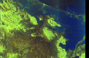
Show Raw Evidence JSON
{
    "vessel_a": {
        "mmsi": 667001964,
        "imo": 9382712,
        "name": "DENVER",
        "flag": "SIERRA LEONE"
    },
    "vessel_b": {
        "mmsi": 613472020,
        "imo": 9299886,
        "name": "JASPER",
        "flag": "CAMEROON"
    },
    "min_distance_m": 48.2999999999999971578290569595992565155029296875,
    "avg_distance_m": 50.89999999999999857891452847979962825775146484375,
    "distance_consistency_m": 2.29999999999999982236431605997495353221893310546875,
    "duration_minutes": 57,
    "overlap_duration_s": 3420,
    "speed_a_avg": 0.01000000000000000020816681711721685132943093776702880859375,
    "speed_a_std": 0.040000000000000000832667268468867405317723751068115234375,
    "speed_b_avg": 0.0299999999999999988897769753748434595763683319091796875,
    "speed_b_std": 0.05000000000000000277555756156289135105907917022705078125,
    "speed_summary": {
        "vessel_a": {
            "avg_sog": 0.01000000000000000020816681711721685132943093776702880859375,
            "max_sog": 0.1000000000000000055511151231257827021181583404541015625
        },
        "vessel_b": {
            "avg_sog": 0.0299999999999999988897769753748434595763683319091796875,
            "max_sog": 0.1000000000000000055511151231257827021181583404541015625
        }
    },
    "time_window": {
        "start": "2026-06-06T13:02:06+00:00",
        "end": "2026-06-06T13:59:06+00:00"
    },
    "points_count": {
        "vessel_a": 8,
        "vessel_b": 8
    },
    "zone_id": "discovered_020",
    "zone_name": "Eastern Mediterranean Monitoring Zone",
    "score": {
        "value": 80,
        "components": {
            "distance_tightness": {
                "score": 25,
                "max": 25,
                "detail": "Min distance 48m, avg 51m"
            },
            "duration": {
                "score": 10,
                "max": 25,
                "detail": "Duration 57 minutes"
            },
            "speed_stability": {
                "score": 20,
                "max": 20,
                "detail": "both nearly stationary; very stable speeds"
            },
            "distance_consistency": {
                "score": 15,
                "max": 15,
                "detail": "Distance variance \u00b12m"
            },
            "isolation": {
                "score": 5,
                "max": 10,
                "detail": "Isolation data not available"
            },
            "context": {
                "score": 5,
                "max": 5,
                "detail": "In monitored zone: Eastern Mediterranean Monitoring Zone"
            }
        },
        "summary": "High-confidence STS candidate. Two tankers (DENVER and JASPER) maintained close proximity (min 48m, avg 51m) for 57 minutes. Both vessels were slow-moving (avg speeds 0.0 and 0.0 knots). The stable separation distance suggests deliberate parallel positioning typical of cargo transfer. Event occurred in Eastern Mediterranean Monitoring Zone, a known STS activity area."
    },
    "sar": {
        "status": "inconclusive",
        "centroid": {
            "lat": 31.51009379999999993060555425472557544708251953125,
            "lon": 32.334170999999997775375959463417530059814453125
        },
        "time_window": {
            "start_ts": "2026-06-06T13:02:06+00:00",
            "end_ts": "2026-06-06T13:59:06+00:00"
        },
        "searched_at": "2026-06-06T19:30:01.829283+00:00",
        "scene_id": "S1D_IW_GRDH_1SDV_20260606T034348_20260606T034413_003110_005639_0EB7_COG",
        "scene_datetime": "2026-06-06T03:43:48.736247Z",
        "platform": "sentinel-1d",
        "bbox": {
            "min_lon": 32.1528739999999970677890814840793609619140625,
            "min_lat": 29.52072700000000082809492596425116062164306640625,
            "max_lon": 35.1772840000000002191882231272757053375244140625,
            "max_lat": 31.44632899999999864348865230567753314971923828125
        },
        "assets": {
            "preview_url": "https:\/\/fleetleaks.com\/wp-content\/uploads\/fleetleaks-evidence\/sar-imagery\/2026\/06\/event_690373_thumbnail_20260606193006.png",
            "stored_path": "\/home\/fleetleaks\/public_html\/wp-content\/uploads\/fleetleaks-evidence\/sar-imagery\/2026\/06\/event_690373_thumbnail_20260606193006.png",
            "source": "copernicus_dataspace"
        },
        "notes": "Preview available for manual review"
    }
}- Zone: Eastern Mediterranean Monitoring Zone
- Duration: 1h 57m
- Data Points: 15 AIS positions
- Period: 2026-06-06T12:02:03+00:00 to 2026-06-06T13:59:06+00:00
Show Raw Evidence JSON
{
    "zone_id": "discovered_020",
    "zone_name": "Eastern Mediterranean Monitoring Zone",
    "dwell_minutes": 117,
    "points_in_zone": 15,
    "first_point": {
        "ts": "2026-06-06T12:02:03+00:00",
        "lat": 31.510091700000000258796717389486730098724365234375,
        "lon": 32.33455500000000171212377608753740787506103515625
    },
    "last_point": {
        "ts": "2026-06-06T13:59:06+00:00",
        "lat": 31.5099866999999989047864801250398159027099609375,
        "lon": 32.3343516999999991412551025860011577606201171875
    }
}- Duration: 1h 57m
- Radius: 35 meters
- Data Points: 15 AIS positions
- Centroid: 31.5101, 32.3345
- Zone: Eastern Mediterranean Monitoring Zone
Show Raw Evidence JSON
{
    "radius_m": 35,
    "duration_minutes": 117,
    "points": 15,
    "centroid": {
        "lat": 31.510058673333336543009863817133009433746337890625,
        "lon": 32.33454900666666986808195360936224460601806640625
    },
    "bbox": {
        "min_lat": 31.509968300000000596128302277065813541412353515625,
        "min_lon": 32.33431999999999817418938619084656238555908203125,
        "max_lat": 31.51013999999999981582732289098203182220458984375,
        "max_lon": 32.33490669999999767014742246828973293304443359375
    },
    "zone_id": "discovered_020"
}- Minimum Distance: 48 meters
- Average Distance: 51 meters
- Duration: 1h 21m
- Period: 2026-06-06T12:38:05+00:00 to 2026-06-06T13:59:06+00:00
- Vessel A Avg Speed: 0.0 knots
- Vessel B Avg Speed: 0.0 knots
- Zone: Eastern Mediterranean Monitoring Zone
Confidence Analysis
High-confidence STS candidate. Two tankers (DENVER and JASPER) maintained close proximity (min 48m, avg 51m) for 81 minutes. Both vessels were slow-moving (avg speeds 0.0 and 0.0 knots). The stable separation distance suggests deliberate parallel positioning typical of cargo transfer. Event occurred in Eastern Mediterranean Monitoring Zone, a known STS activity area.
View scoring breakdown
| Factor | Score | Detail |
|---|---|---|
| Distance Tightness | 25/25 | Min distance 48m, avg 51m |
| Duration | 15/25 | Duration 81 minutes |
| Speed Stability | 20/20 | both nearly stationary; very stable speeds |
| Distance Consistency | 15/15 | Distance variance ±2m |
| Isolation | 5/10 | Isolation data not available |
| Context | 5/5 | In monitored zone: Eastern Mediterranean Monitoring Zone |
Show Raw Evidence JSON
{
    "vessel_a": {
        "mmsi": 667001964,
        "imo": 9382712,
        "name": "DENVER",
        "flag": "SIERRA LEONE"
    },
    "vessel_b": {
        "mmsi": 613472020,
        "imo": 9299886,
        "name": "JASPER",
        "flag": "CAMEROON"
    },
    "min_distance_m": 47.7999999999999971578290569595992565155029296875,
    "avg_distance_m": 50.7999999999999971578290569595992565155029296875,
    "distance_consistency_m": 2.399999999999999911182158029987476766109466552734375,
    "duration_minutes": 81,
    "overlap_duration_s": 4861,
    "speed_a_avg": 0.0200000000000000004163336342344337026588618755340576171875,
    "speed_a_std": 0.040000000000000000832667268468867405317723751068115234375,
    "speed_b_avg": 0.0200000000000000004163336342344337026588618755340576171875,
    "speed_b_std": 0.040000000000000000832667268468867405317723751068115234375,
    "speed_summary": {
        "vessel_a": {
            "avg_sog": 0.0200000000000000004163336342344337026588618755340576171875,
            "max_sog": 0.1000000000000000055511151231257827021181583404541015625
        },
        "vessel_b": {
            "avg_sog": 0.0200000000000000004163336342344337026588618755340576171875,
            "max_sog": 0.1000000000000000055511151231257827021181583404541015625
        }
    },
    "time_window": {
        "start": "2026-06-06T12:38:05+00:00",
        "end": "2026-06-06T13:59:06+00:00"
    },
    "points_count": {
        "vessel_a": 10,
        "vessel_b": 10
    },
    "zone_id": "discovered_020",
    "zone_name": "Eastern Mediterranean Monitoring Zone",
    "score": {
        "value": 85,
        "components": {
            "distance_tightness": {
                "score": 25,
                "max": 25,
                "detail": "Min distance 48m, avg 51m"
            },
            "duration": {
                "score": 15,
                "max": 25,
                "detail": "Duration 81 minutes"
            },
            "speed_stability": {
                "score": 20,
                "max": 20,
                "detail": "both nearly stationary; very stable speeds"
            },
            "distance_consistency": {
                "score": 15,
                "max": 15,
                "detail": "Distance variance \u00b12m"
            },
            "isolation": {
                "score": 5,
                "max": 10,
                "detail": "Isolation data not available"
            },
            "context": {
                "score": 5,
                "max": 5,
                "detail": "In monitored zone: Eastern Mediterranean Monitoring Zone"
            }
        },
        "summary": "High-confidence STS candidate. Two tankers (DENVER and JASPER) maintained close proximity (min 48m, avg 51m) for 81 minutes. Both vessels were slow-moving (avg speeds 0.0 and 0.0 knots). The stable separation distance suggests deliberate parallel positioning typical of cargo transfer. Event occurred in Eastern Mediterranean Monitoring Zone, a known STS activity area."
    }
}- Zone: Eastern Mediterranean Monitoring Zone
- Duration: 2h 15m
- Data Points: 18 AIS positions
- Period: 2026-06-06T11:44:06+00:00 to 2026-06-06T13:59:06+00:00
Show Raw Evidence JSON
{
    "zone_id": "discovered_020",
    "zone_name": "Eastern Mediterranean Monitoring Zone",
    "dwell_minutes": 135,
    "points_in_zone": 18,
    "first_point": {
        "ts": "2026-06-06T11:44:06+00:00",
        "lat": 31.51017999999999830151864443905651569366455078125,
        "lon": 32.33480329999999725032466812990605831146240234375
    },
    "last_point": {
        "ts": "2026-06-06T13:59:06+00:00",
        "lat": 31.5099866999999989047864801250398159027099609375,
        "lon": 32.3343516999999991412551025860011577606201171875
    }
}- Duration: 2h 15m
- Radius: 32 meters
- Data Points: 18 AIS positions
- Centroid: 31.5101, 32.3346
- Zone: Eastern Mediterranean Monitoring Zone
Show Raw Evidence JSON
{
    "radius_m": 31.800000000000000710542735760100185871124267578125,
    "duration_minutes": 135,
    "points": 18,
    "centroid": {
        "lat": 31.51007510000000166883182828314602375030517578125,
        "lon": 32.334578800000002729575498960912227630615234375
    },
    "bbox": {
        "min_lat": 31.509968300000000596128302277065813541412353515625,
        "min_lon": 32.33431999999999817418938619084656238555908203125,
        "max_lat": 31.51017999999999830151864443905651569366455078125,
        "max_lon": 32.33490669999999767014742246828973293304443359375
    },
    "zone_id": "discovered_020"
}- Minimum Distance: 40 meters
- Average Distance: 50 meters
- Duration: 2h 15m
- Period: 2026-06-06T11:40:15+00:00 to 2026-06-06T13:55:25+00:00
- Vessel A Avg Speed: 0.1 knots
- Vessel B Avg Speed: 0.1 knots
- Zone: Eastern Mediterranean Monitoring Zone
Confidence Analysis
High-confidence STS candidate. Two tankers (JASPER and DENVER) maintained close proximity (min 40m, avg 50m) for 135 minutes. Both vessels were slow-moving (avg speeds 0.1 and 0.1 knots). The stable separation distance suggests deliberate parallel positioning typical of cargo transfer. Event occurred in Eastern Mediterranean Monitoring Zone, a known STS activity area.
View scoring breakdown
| Factor | Score | Detail |
|---|---|---|
| Distance Tightness | 25/25 | Min distance 40m, avg 50m |
| Duration | 25/25 | Duration 135 minutes |
| Speed Stability | 20/20 | both nearly stationary; very stable speeds |
| Distance Consistency | 15/15 | Distance variance ±6m |
| Isolation | 5/10 | Isolation data not available |
| Context | 5/5 | In monitored zone: Eastern Mediterranean Monitoring Zone |
Show Raw Evidence JSON
{
    "vessel_a": {
        "mmsi": 613472020,
        "imo": 9299886,
        "name": "JASPER",
        "flag": "CAMEROON"
    },
    "vessel_b": {
        "mmsi": 667001964,
        "imo": 9382712,
        "name": "DENVER",
        "flag": "SIERRA LEONE"
    },
    "min_distance_m": 39.7000000000000028421709430404007434844970703125,
    "avg_distance_m": 50.2999999999999971578290569595992565155029296875,
    "distance_consistency_m": 5.79999999999999982236431605997495353221893310546875,
    "duration_minutes": 135.19999999999998863131622783839702606201171875,
    "overlap_duration_s": 8110,
    "speed_a_avg": 0.05000000000000000277555756156289135105907917022705078125,
    "speed_a_std": 0.05000000000000000277555756156289135105907917022705078125,
    "speed_b_avg": 0.05000000000000000277555756156289135105907917022705078125,
    "speed_b_std": 0.05000000000000000277555756156289135105907917022705078125,
    "speed_summary": {
        "vessel_a": {
            "avg_sog": 0.05000000000000000277555756156289135105907917022705078125,
            "max_sog": 0.1000000000000000055511151231257827021181583404541015625
        },
        "vessel_b": {
            "avg_sog": 0.05000000000000000277555756156289135105907917022705078125,
            "max_sog": 0.1000000000000000055511151231257827021181583404541015625
        }
    },
    "time_window": {
        "start": "2026-06-06T11:40:15+00:00",
        "end": "2026-06-06T13:55:25+00:00"
    },
    "points_count": {
        "vessel_a": 39,
        "vessel_b": 39
    },
    "zone_id": "discovered_020",
    "zone_name": "Eastern Mediterranean Monitoring Zone",
    "score": {
        "value": 95,
        "components": {
            "distance_tightness": {
                "score": 25,
                "max": 25,
                "detail": "Min distance 40m, avg 50m"
            },
            "duration": {
                "score": 25,
                "max": 25,
                "detail": "Duration 135 minutes"
            },
            "speed_stability": {
                "score": 20,
                "max": 20,
                "detail": "both nearly stationary; very stable speeds"
            },
            "distance_consistency": {
                "score": 15,
                "max": 15,
                "detail": "Distance variance \u00b16m"
            },
            "isolation": {
                "score": 5,
                "max": 10,
                "detail": "Isolation data not available"
            },
            "context": {
                "score": 5,
                "max": 5,
                "detail": "In monitored zone: Eastern Mediterranean Monitoring Zone"
            }
        },
        "summary": "High-confidence STS candidate. Two tankers (JASPER and DENVER) maintained close proximity (min 40m, avg 50m) for 135 minutes. Both vessels were slow-moving (avg speeds 0.1 and 0.1 knots). The stable separation distance suggests deliberate parallel positioning typical of cargo transfer. Event occurred in Eastern Mediterranean Monitoring Zone, a known STS activity area."
    }
}- Minimum Distance: 46 meters
- Average Distance: 50 meters
- Duration: 3h 6m
- Period: 2026-06-06T10:53:04+00:00 to 2026-06-06T13:59:06+00:00
- Vessel A Avg Speed: 0.1 knots
- Vessel B Avg Speed: 0.0 knots
- Zone: Eastern Mediterranean Monitoring Zone
Confidence Analysis
High-confidence STS candidate. Two tankers (DENVER and JASPER) maintained close proximity (min 46m, avg 50m) for 186 minutes. Both vessels were slow-moving (avg speeds 0.1 and 0.0 knots). The stable separation distance suggests deliberate parallel positioning typical of cargo transfer. Event occurred in Eastern Mediterranean Monitoring Zone, a known STS activity area.
View scoring breakdown
| Factor | Score | Detail |
|---|---|---|
| Distance Tightness | 25/25 | Min distance 46m, avg 50m |
| Duration | 25/25 | Duration 186 minutes |
| Speed Stability | 20/20 | both nearly stationary; very stable speeds |
| Distance Consistency | 15/15 | Distance variance ±3m |
| Isolation | 5/10 | Isolation data not available |
| Context | 5/5 | In monitored zone: Eastern Mediterranean Monitoring Zone |
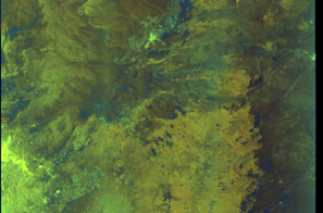
🛰️ Satellite Corroboration
Satellite imagery available but requires review
Preview available for manual review

Show Raw Evidence JSON
{
    "vessel_a": {
        "mmsi": 667001964,
        "imo": 9382712,
        "name": "DENVER",
        "flag": "SIERRA LEONE"
    },
    "vessel_b": {
        "mmsi": 613472020,
        "imo": 9299886,
        "name": "JASPER",
        "flag": "CAMEROON"
    },
    "min_distance_m": 46,
    "avg_distance_m": 50,
    "distance_consistency_m": 2.600000000000000088817841970012523233890533447265625,
    "duration_minutes": 186,
    "overlap_duration_s": 11162,
    "speed_a_avg": 0.05000000000000000277555756156289135105907917022705078125,
    "speed_a_std": 0.05000000000000000277555756156289135105907917022705078125,
    "speed_b_avg": 0.0299999999999999988897769753748434595763683319091796875,
    "speed_b_std": 0.05000000000000000277555756156289135105907917022705078125,
    "speed_summary": {
        "vessel_a": {
            "avg_sog": 0.05000000000000000277555756156289135105907917022705078125,
            "max_sog": 0.1000000000000000055511151231257827021181583404541015625
        },
        "vessel_b": {
            "avg_sog": 0.0299999999999999988897769753748434595763683319091796875,
            "max_sog": 0.1000000000000000055511151231257827021181583404541015625
        }
    },
    "time_window": {
        "start": "2026-06-06T10:53:04+00:00",
        "end": "2026-06-06T13:59:06+00:00"
    },
    "points_count": {
        "vessel_a": 19,
        "vessel_b": 19
    },
    "zone_id": "discovered_020",
    "zone_name": "Eastern Mediterranean Monitoring Zone",
    "score": {
        "value": 95,
        "components": {
            "distance_tightness": {
                "score": 25,
                "max": 25,
                "detail": "Min distance 46m, avg 50m"
            },
            "duration": {
                "score": 25,
                "max": 25,
                "detail": "Duration 186 minutes"
            },
            "speed_stability": {
                "score": 20,
                "max": 20,
                "detail": "both nearly stationary; very stable speeds"
            },
            "distance_consistency": {
                "score": 15,
                "max": 15,
                "detail": "Distance variance \u00b13m"
            },
            "isolation": {
                "score": 5,
                "max": 10,
                "detail": "Isolation data not available"
            },
            "context": {
                "score": 5,
                "max": 5,
                "detail": "In monitored zone: Eastern Mediterranean Monitoring Zone"
            }
        },
        "summary": "High-confidence STS candidate. Two tankers (DENVER and JASPER) maintained close proximity (min 46m, avg 50m) for 186 minutes. Both vessels were slow-moving (avg speeds 0.1 and 0.0 knots). The stable separation distance suggests deliberate parallel positioning typical of cargo transfer. Event occurred in Eastern Mediterranean Monitoring Zone, a known STS activity area."
    },
    "sar": {
        "status": "inconclusive",
        "centroid": {
            "lat": 31.51015939999999915244188741780817508697509765625,
            "lon": 32.3343641000000019403159967623651027679443359375
        },
        "time_window": {
            "start_ts": "2026-06-06T10:53:04+00:00",
            "end_ts": "2026-06-06T13:59:06+00:00"
        },
        "searched_at": "2026-06-06T17:30:06.729472+00:00",
        "scene_id": "S1D_IW_GRDH_1SDV_20260606T034348_20260606T034413_003110_005639_0EB7_COG",
        "scene_datetime": "2026-06-06T03:43:48.736247Z",
        "platform": "sentinel-1d",
        "bbox": {
            "min_lon": 32.1528739999999970677890814840793609619140625,
            "min_lat": 29.52072700000000082809492596425116062164306640625,
            "max_lon": 35.1772840000000002191882231272757053375244140625,
            "max_lat": 31.44632899999999864348865230567753314971923828125
        },
        "assets": {
            "preview_url": "https:\/\/fleetleaks.com\/wp-content\/uploads\/fleetleaks-evidence\/sar-imagery\/2026\/06\/event_689657_thumbnail_20260606173010.png",
            "stored_path": "\/home\/fleetleaks\/public_html\/wp-content\/uploads\/fleetleaks-evidence\/sar-imagery\/2026\/06\/event_689657_thumbnail_20260606173010.png",
            "source": "copernicus_dataspace"
        },
        "notes": "Preview available for manual review"
    }
}- Zone: Eastern Mediterranean Monitoring Zone
- Duration: 3h 21m
- Data Points: 22 AIS positions
- Period: 2026-06-06T10:38:05+00:00 to 2026-06-06T13:59:06+00:00
Show Raw Evidence JSON
{
    "zone_id": "discovered_020",
    "zone_name": "Eastern Mediterranean Monitoring Zone",
    "dwell_minutes": 201,
    "points_in_zone": 22,
    "first_point": {
        "ts": "2026-06-06T10:38:05+00:00",
        "lat": 31.510531700000001364969648420810699462890625,
        "lon": 32.33548170000000254731276072561740875244140625
    },
    "last_point": {
        "ts": "2026-06-06T13:59:06+00:00",
        "lat": 31.5099866999999989047864801250398159027099609375,
        "lon": 32.3343516999999991412551025860011577606201171875
    }
}- Duration: 3h 21m
- Radius: 83 meters
- Data Points: 22 AIS positions
- Centroid: 31.5102, 32.3347
- Zone: Eastern Mediterranean Monitoring Zone
Show Raw Evidence JSON
{
    "radius_m": 83.099999999999994315658113919198513031005859375,
    "duration_minutes": 201,
    "points": 22,
    "centroid": {
        "lat": 31.510157504545450279920260072685778141021728515625,
        "lon": 32.33472394545454875469658873043954372406005859375
    },
    "bbox": {
        "min_lat": 31.509968300000000596128302277065813541412353515625,
        "min_lon": 32.33431999999999817418938619084656238555908203125,
        "max_lat": 31.510553300000001542002792120911180973052978515625,
        "max_lon": 32.33548170000000254731276072561740875244140625
    },
    "zone_id": "discovered_020"
}- Minimum Distance: 46 meters
- Average Distance: 50 meters
- Duration: 4h 39m
- Period: 2026-06-06T09:20:06+00:00 to 2026-06-06T13:59:06+00:00
- Vessel A Avg Speed: 0.0 knots
- Vessel B Avg Speed: 0.0 knots
- Zone: Eastern Mediterranean Monitoring Zone
Confidence Analysis
High-confidence STS candidate. Two tankers (DENVER and JASPER) maintained close proximity (min 46m, avg 50m) for 279 minutes. Both vessels were slow-moving (avg speeds 0.0 and 0.0 knots). The stable separation distance suggests deliberate parallel positioning typical of cargo transfer. Event occurred in Eastern Mediterranean Monitoring Zone, a known STS activity area.
View scoring breakdown
| Factor | Score | Detail |
|---|---|---|
| Distance Tightness | 25/25 | Min distance 46m, avg 50m |
| Duration | 25/25 | Duration 279 minutes |
| Speed Stability | 20/20 | both nearly stationary; very stable speeds |
| Distance Consistency | 15/15 | Distance variance ±2m |
| Isolation | 5/10 | Isolation data not available |
| Context | 5/5 | In monitored zone: Eastern Mediterranean Monitoring Zone |
Show Raw Evidence JSON
{
    "vessel_a": {
        "mmsi": 667001964,
        "imo": 9382712,
        "name": "DENVER",
        "flag": "SIERRA LEONE"
    },
    "vessel_b": {
        "mmsi": 613472020,
        "imo": 9299886,
        "name": "JASPER",
        "flag": "CAMEROON"
    },
    "min_distance_m": 46,
    "avg_distance_m": 50.39999999999999857891452847979962825775146484375,
    "distance_consistency_m": 2.5,
    "duration_minutes": 279,
    "overlap_duration_s": 16740,
    "speed_a_avg": 0.040000000000000000832667268468867405317723751068115234375,
    "speed_a_std": 0.05000000000000000277555756156289135105907917022705078125,
    "speed_b_avg": 0.0299999999999999988897769753748434595763683319091796875,
    "speed_b_std": 0.05000000000000000277555756156289135105907917022705078125,
    "speed_summary": {
        "vessel_a": {
            "avg_sog": 0.040000000000000000832667268468867405317723751068115234375,
            "max_sog": 0.1000000000000000055511151231257827021181583404541015625
        },
        "vessel_b": {
            "avg_sog": 0.0299999999999999988897769753748434595763683319091796875,
            "max_sog": 0.1000000000000000055511151231257827021181583404541015625
        }
    },
    "time_window": {
        "start": "2026-06-06T09:20:06+00:00",
        "end": "2026-06-06T13:59:06+00:00"
    },
    "points_count": {
        "vessel_a": 27,
        "vessel_b": 27
    },
    "zone_id": "discovered_020",
    "zone_name": "Eastern Mediterranean Monitoring Zone",
    "score": {
        "value": 95,
        "components": {
            "distance_tightness": {
                "score": 25,
                "max": 25,
                "detail": "Min distance 46m, avg 50m"
            },
            "duration": {
                "score": 25,
                "max": 25,
                "detail": "Duration 279 minutes"
            },
            "speed_stability": {
                "score": 20,
                "max": 20,
                "detail": "both nearly stationary; very stable speeds"
            },
            "distance_consistency": {
                "score": 15,
                "max": 15,
                "detail": "Distance variance \u00b12m"
            },
            "isolation": {
                "score": 5,
                "max": 10,
                "detail": "Isolation data not available"
            },
            "context": {
                "score": 5,
                "max": 5,
                "detail": "In monitored zone: Eastern Mediterranean Monitoring Zone"
            }
        },
        "summary": "High-confidence STS candidate. Two tankers (DENVER and JASPER) maintained close proximity (min 46m, avg 50m) for 279 minutes. Both vessels were slow-moving (avg speeds 0.0 and 0.0 knots). The stable separation distance suggests deliberate parallel positioning typical of cargo transfer. Event occurred in Eastern Mediterranean Monitoring Zone, a known STS activity area."
    }
}- Zone: Eastern Mediterranean Monitoring Zone
- Duration: 4h 48m
- Data Points: 28 AIS positions
- Period: 2026-06-06T09:11:03+00:00 to 2026-06-06T13:59:06+00:00
Show Raw Evidence JSON
{
    "zone_id": "discovered_020",
    "zone_name": "Eastern Mediterranean Monitoring Zone",
    "dwell_minutes": 288.1000000000000227373675443232059478759765625,
    "points_in_zone": 28,
    "first_point": {
        "ts": "2026-06-06T09:11:03+00:00",
        "lat": 31.5115033000000011043084668926894664764404296875,
        "lon": 32.33620499999999964302332955412566661834716796875
    },
    "last_point": {
        "ts": "2026-06-06T13:59:06+00:00",
        "lat": 31.5099866999999989047864801250398159027099609375,
        "lon": 32.3343516999999991412551025860011577606201171875
    }
}- Duration: 4h 48m
- Radius: 166 meters
- Data Points: 28 AIS positions
- Centroid: 31.5104, 32.3350
- Zone: Eastern Mediterranean Monitoring Zone
Show Raw Evidence JSON
{
    "radius_m": 166,
    "duration_minutes": 288.1000000000000227373675443232059478759765625,
    "points": 28,
    "centroid": {
        "lat": 31.5104036357142831548117101192474365234375,
        "lon": 32.33501839285714396510229562409222126007080078125
    },
    "bbox": {
        "min_lat": 31.509968300000000596128302277065813541412353515625,
        "min_lon": 32.33431999999999817418938619084656238555908203125,
        "max_lat": 31.5115033000000011043084668926894664764404296875,
        "max_lon": 32.33620499999999964302332955412566661834716796875
    },
    "zone_id": "discovered_020"
}- Zone: Eastern Mediterranean Monitoring Zone
- Duration: 5h 48m
- Data Points: 32 AIS positions
- Period: 2026-06-06T08:11:05+00:00 to 2026-06-06T13:59:06+00:00
Show Raw Evidence JSON
{
    "zone_id": "discovered_020",
    "zone_name": "Eastern Mediterranean Monitoring Zone",
    "dwell_minutes": 348,
    "points_in_zone": 32,
    "first_point": {
        "ts": "2026-06-06T08:11:05+00:00",
        "lat": 31.51215499999999991587174008600413799285888671875,
        "lon": 32.3360066999999986592229106463491916656494140625
    },
    "last_point": {
        "ts": "2026-06-06T13:59:06+00:00",
        "lat": 31.5099866999999989047864801250398159027099609375,
        "lon": 32.3343516999999991412551025860011577606201171875
    }
}- Duration: 5h 48m
- Radius: 190 meters
- Data Points: 32 AIS positions
- Centroid: 31.5106, 32.3352
- Zone: Eastern Mediterranean Monitoring Zone
Show Raw Evidence JSON
{
    "radius_m": 190.30000000000001136868377216160297393798828125,
    "duration_minutes": 348,
    "points": 32,
    "centroid": {
        "lat": 31.510600784374997118675310048274695873260498046875,
        "lon": 32.3351569281250021958840079605579376220703125
    },
    "bbox": {
        "min_lat": 31.509968300000000596128302277065813541412353515625,
        "min_lon": 32.33431999999999817418938619084656238555908203125,
        "max_lat": 31.51215499999999991587174008600413799285888671875,
        "max_lon": 32.33620499999999964302332955412566661834716796875
    },
    "zone_id": "discovered_020"
}- Duration: 6h 3m
- Radius: 208 meters
- Data Points: 33 AIS positions
- Centroid: 31.5107, 32.3352
- Zone: Eastern Mediterranean Monitoring Zone
Show Raw Evidence JSON
{
    "radius_m": 208.19999999999998863131622783839702606201171875,
    "duration_minutes": 363,
    "points": 33,
    "centroid": {
        "lat": 31.51065697272726850997059955261647701263427734375,
        "lon": 32.335176718181827482112566940486431121826171875
    },
    "bbox": {
        "min_lat": 31.509968300000000596128302277065813541412353515625,
        "min_lon": 32.33431999999999817418938619084656238555908203125,
        "max_lat": 31.512454999999999216697688098065555095672607421875,
        "max_lon": 32.33620499999999964302332955412566661834716796875
    },
    "zone_id": "discovered_020"
}- Zone: Eastern Mediterranean Monitoring Zone
- Duration: 6h 3m
- Data Points: 33 AIS positions
- Period: 2026-06-06T07:56:05+00:00 to 2026-06-06T13:59:06+00:00
Show Raw Evidence JSON
{
    "zone_id": "discovered_020",
    "zone_name": "Eastern Mediterranean Monitoring Zone",
    "dwell_minutes": 363,
    "points_in_zone": 33,
    "first_point": {
        "ts": "2026-06-06T07:56:05+00:00",
        "lat": 31.512454999999999216697688098065555095672607421875,
        "lon": 32.33581000000000216232365346513688564300537109375
    },
    "last_point": {
        "ts": "2026-06-06T13:59:06+00:00",
        "lat": 31.5099866999999989047864801250398159027099609375,
        "lon": 32.3343516999999991412551025860011577606201171875
    }
}- Zone: Eastern Mediterranean Monitoring Zone
- Duration: 6h 35m
- Data Points: 28 AIS positions
- Period: 2026-06-06T06:32:23+00:00 to 2026-06-06T13:08:06+00:00
Show Raw Evidence JSON
{
    "zone_id": "discovered_020",
    "zone_name": "Eastern Mediterranean Monitoring Zone",
    "dwell_minutes": 395.69999999999998863131622783839702606201171875,
    "points_in_zone": 28,
    "first_point": {
        "ts": "2026-06-06T06:32:23+00:00",
        "lat": 31.535489999999999355395630118437111377716064453125,
        "lon": 32.33897999999999939291228656657040119171142578125
    },
    "last_point": {
        "ts": "2026-06-06T13:08:06+00:00",
        "lat": 31.510051700000001773105395841412246227264404296875,
        "lon": 32.33454329999999998790372046642005443572998046875
    }
}- Zone: Eastern Mediterranean Monitoring Zone
- Duration: 5h 48m
- Data Points: 17 AIS positions
- Period: 2026-06-06T05:04:44+00:00 to 2026-06-06T10:53:04+00:00
Show Raw Evidence JSON
{
    "zone_id": "discovered_020",
    "zone_name": "Eastern Mediterranean Monitoring Zone",
    "dwell_minutes": 348.30000000000001136868377216160297393798828125,
    "points_in_zone": 17,
    "first_point": {
        "ts": "2026-06-06T05:04:44+00:00",
        "lat": 31.599168299999998765770214959047734737396240234375,
        "lon": 32.3372183000000035235643736086785793304443359375
    },
    "last_point": {
        "ts": "2026-06-06T10:53:04+00:00",
        "lat": 31.510503299999999882174961385317146778106689453125,
        "lon": 32.33526330000000115205693873576819896697998046875
    }
}- Zone: Eastern Mediterranean Monitoring Zone
- Duration: 6h 30m
- Data Points: 23 AIS positions
- Period: 2026-06-06T04:22:24+00:00 to 2026-06-06T10:53:04+00:00
Show Raw Evidence JSON
{
    "zone_id": "discovered_020",
    "zone_name": "Eastern Mediterranean Monitoring Zone",
    "dwell_minutes": 390.69999999999998863131622783839702606201171875,
    "points_in_zone": 23,
    "first_point": {
        "ts": "2026-06-06T04:22:24+00:00",
        "lat": 31.557906700000000199679561774246394634246826171875,
        "lon": 32.35894499999999851524989935569465160369873046875
    },
    "last_point": {
        "ts": "2026-06-06T10:53:04+00:00",
        "lat": 31.510503299999999882174961385317146778106689453125,
        "lon": 32.33526330000000115205693873576819896697998046875
    }
}- Zone: Eastern Mediterranean Monitoring Zone
- Duration: 6h 21m
- Data Points: 3 AIS positions
- Period: 2026-06-05T22:01:05+00:00 to 2026-06-06T04:22:24+00:00
Show Raw Evidence JSON
{
    "zone_id": "discovered_020",
    "zone_name": "Eastern Mediterranean Monitoring Zone",
    "dwell_minutes": 381.30000000000001136868377216160297393798828125,
    "points_in_zone": 3,
    "first_point": {
        "ts": "2026-06-05T22:01:05+00:00",
        "lat": 31.53870500000000021145751816220581531524658203125,
        "lon": 32.3637767000000025063854991458356380462646484375
    },
    "last_point": {
        "ts": "2026-06-06T04:22:24+00:00",
        "lat": 31.557906700000000199679561774246394634246826171875,
        "lon": 32.35894499999999851524989935569465160369873046875
    }
}- Zone: Eastern Mediterranean Monitoring Zone
- Duration: 6h 11m
- Data Points: 3 AIS positions
- Period: 2026-06-05T21:49:09+00:00 to 2026-06-06T04:01:05+00:00
Show Raw Evidence JSON
{
    "zone_id": "discovered_020",
    "zone_name": "Eastern Mediterranean Monitoring Zone",
    "dwell_minutes": 371.8999999999999772626324556767940521240234375,
    "points_in_zone": 3,
    "first_point": {
        "ts": "2026-06-05T21:49:09+00:00",
        "lat": 31.53866000000000013869794202037155628204345703125,
        "lon": 32.36368329999999815527189639396965503692626953125
    },
    "last_point": {
        "ts": "2026-06-06T04:01:05+00:00",
        "lat": 31.539404999999998580051396857015788555145263671875,
        "lon": 32.3630332999999978937921696342527866363525390625
    }
}- Zone: Eastern Mediterranean Monitoring Zone
- Duration: 1h 39m
- Data Points: 3 AIS positions
- Period: 2026-06-05T20:22:04+00:00 to 2026-06-05T22:01:05+00:00
Show Raw Evidence JSON
{
    "zone_id": "discovered_020",
    "zone_name": "Eastern Mediterranean Monitoring Zone",
    "dwell_minutes": 99,
    "points_in_zone": 3,
    "first_point": {
        "ts": "2026-06-05T20:22:04+00:00",
        "lat": 31.53794500000000056161297834478318691253662109375,
        "lon": 32.363484999999997171471477486193180084228515625
    },
    "last_point": {
        "ts": "2026-06-05T22:01:05+00:00",
        "lat": 31.53870500000000021145751816220581531524658203125,
        "lon": 32.3637767000000025063854991458356380462646484375
    }
}- Zone: Eastern Mediterranean Monitoring Zone
- Duration: 3 hours
- Data Points: 15 AIS positions
- Period: 2026-06-05T19:01:02+00:00 to 2026-06-05T22:01:05+00:00
Show Raw Evidence JSON
{
    "zone_id": "discovered_020",
    "zone_name": "Eastern Mediterranean Monitoring Zone",
    "dwell_minutes": 180.099999999999994315658113919198513031005859375,
    "points_in_zone": 15,
    "first_point": {
        "ts": "2026-06-05T19:01:02+00:00",
        "lat": 31.537220000000001363105184282176196575164794921875,
        "lon": 32.363758300000000645013642497360706329345703125
    },
    "last_point": {
        "ts": "2026-06-05T22:01:05+00:00",
        "lat": 31.53870500000000021145751816220581531524658203125,
        "lon": 32.3637767000000025063854991458356380462646484375
    }
}- Duration: 3 hours
- Radius: 119 meters
- Data Points: 15 AIS positions
- Centroid: 31.5376, 32.3636
- Zone: Eastern Mediterranean Monitoring Zone
Show Raw Evidence JSON
{
    "radius_m": 118.599999999999994315658113919198513031005859375,
    "duration_minutes": 180.099999999999994315658113919198513031005859375,
    "points": 15,
    "centroid": {
        "lat": 31.537641213333333922719248221255838871002197265625,
        "lon": 32.3636428933333348822998232208192348480224609375
    },
    "bbox": {
        "min_lat": 31.53721829999999926030795904807746410369873046875,
        "min_lon": 32.363484999999997171471477486193180084228515625,
        "max_lat": 31.53870500000000021145751816220581531524658203125,
        "max_lon": 32.3637767000000025063854991458356380462646484375
    },
    "zone_id": "discovered_020"
}- Zone: Eastern Mediterranean Monitoring Zone
- Duration: 3h 45m
- Data Points: 21 AIS positions
- Period: 2026-06-05T18:16:03+00:00 to 2026-06-05T22:01:05+00:00
Show Raw Evidence JSON
{
    "zone_id": "discovered_020",
    "zone_name": "Eastern Mediterranean Monitoring Zone",
    "dwell_minutes": 225,
    "points_in_zone": 21,
    "first_point": {
        "ts": "2026-06-05T18:16:03+00:00",
        "lat": 31.536995000000000999307303573004901409149169921875,
        "lon": 32.36395999999999872898115427233278751373291015625
    },
    "last_point": {
        "ts": "2026-06-05T22:01:05+00:00",
        "lat": 31.53870500000000021145751816220581531524658203125,
        "lon": 32.3637767000000025063854991458356380462646484375
    }
}- Duration: 3h 45m
- Radius: 134 meters
- Data Points: 21 AIS positions
- Centroid: 31.5375, 32.3637
- Zone: Eastern Mediterranean Monitoring Zone
Show Raw Evidence JSON
{
    "radius_m": 134.30000000000001136868377216160297393798828125,
    "duration_minutes": 225,
    "points": 21,
    "centroid": {
        "lat": 31.5374962619047636280811275355517864227294921875,
        "lon": 32.36368714285714531797566451132297515869140625
    },
    "bbox": {
        "min_lat": 31.536995000000000999307303573004901409149169921875,
        "min_lon": 32.363484999999997171471477486193180084228515625,
        "max_lat": 31.53870500000000021145751816220581531524658203125,
        "max_lon": 32.36395999999999872898115427233278751373291015625
    },
    "zone_id": "discovered_020"
}- Zone: Eastern Mediterranean Monitoring Zone
- Duration: 5 hours
- Data Points: 30 AIS positions
- Period: 2026-06-05T17:01:07+00:00 to 2026-06-05T22:01:05+00:00
Show Raw Evidence JSON
{
    "zone_id": "discovered_020",
    "zone_name": "Eastern Mediterranean Monitoring Zone",
    "dwell_minutes": 300,
    "points_in_zone": 30,
    "first_point": {
        "ts": "2026-06-05T17:01:07+00:00",
        "lat": 31.53676829999999853271219762973487377166748046875,
        "lon": 32.36418499999999909277903498150408267974853515625
    },
    "last_point": {
        "ts": "2026-06-05T22:01:05+00:00",
        "lat": 31.53870500000000021145751816220581531524658203125,
        "lon": 32.3637767000000025063854991458356380462646484375
    }
}- Duration: 5 hours
- Radius: 158 meters
- Data Points: 30 AIS positions
- Centroid: 31.5373, 32.3638
- Zone: Eastern Mediterranean Monitoring Zone
Show Raw Evidence JSON
{
    "radius_m": 157.900000000000005684341886080801486968994140625,
    "duration_minutes": 300,
    "points": 30,
    "centroid": {
        "lat": 31.53728138000000313923010253347456455230712890625,
        "lon": 32.363828116666667256140499375760555267333984375
    },
    "bbox": {
        "min_lat": 31.536764999999999048441168270073831081390380859375,
        "min_lon": 32.363484999999997171471477486193180084228515625,
        "max_lat": 31.53870500000000021145751816220581531524658203125,
        "max_lon": 32.364221700000001646913005970418453216552734375
    },
    "zone_id": "discovered_020"
}- Zone: Eastern Mediterranean Monitoring Zone
- Duration: 5h 3m
- Data Points: 31 AIS positions
- Period: 2026-06-05T16:58:05+00:00 to 2026-06-05T22:01:05+00:00
Show Raw Evidence JSON
{
    "zone_id": "discovered_020",
    "zone_name": "Eastern Mediterranean Monitoring Zone",
    "dwell_minutes": 303,
    "points_in_zone": 31,
    "first_point": {
        "ts": "2026-06-05T16:58:05+00:00",
        "lat": 31.5367482999999992898665368556976318359375,
        "lon": 32.36417999999999750571078038774430751800537109375
    },
    "last_point": {
        "ts": "2026-06-05T22:01:05+00:00",
        "lat": 31.53870500000000021145751816220581531524658203125,
        "lon": 32.3637767000000025063854991458356380462646484375
    }
}- Duration: 5h 3m
- Radius: 160 meters
- Data Points: 31 AIS positions
- Centroid: 31.5373, 32.3638
- Zone: Eastern Mediterranean Monitoring Zone
Show Raw Evidence JSON
{
    "radius_m": 159.900000000000005684341886080801486968994140625,
    "duration_minutes": 303,
    "points": 31,
    "centroid": {
        "lat": 31.537264183870970413181566982530057430267333984375,
        "lon": 32.36383946774193276496589533053338527679443359375
    },
    "bbox": {
        "min_lat": 31.5367482999999992898665368556976318359375,
        "min_lon": 32.363484999999997171471477486193180084228515625,
        "max_lat": 31.53870500000000021145751816220581531524658203125,
        "max_lon": 32.364221700000001646913005970418453216552734375
    },
    "zone_id": "discovered_020"
}- Minimum Distance: 0 meters
- Average Distance: 9 meters
- Duration: 34 minutes
- Period: 2026-06-05T15:59:49+00:00 to 2026-06-05T16:33:56+00:00
- Vessel A Avg Speed: 0.2 knots
- Vessel B Avg Speed: 0.0 knots
- Zone: Eastern Mediterranean Surveillance Zone
Confidence Analysis
Moderate-confidence STS candidate. Two tankers (MUMBAI and DENVER) maintained close proximity (min 0m, avg 9m) for 34 minutes. Both vessels were slow-moving (avg speeds 0.2 and 0.0 knots). The stable separation distance suggests deliberate parallel positioning typical of cargo transfer. Event occurred in Eastern Mediterranean Surveillance Zone, a known STS activity area.
View scoring breakdown
| Factor | Score | Detail |
|---|---|---|
| Distance Tightness | 25/25 | Min distance 0m, avg 9m |
| Duration | 5/25 | Duration 34 minutes |
| Speed Stability | 17/20 | both nearly stationary; stable speeds |
| Distance Consistency | 15/15 | Distance variance ±11m |
| Isolation | 5/10 | Isolation data not available |
| Context | 5/5 | In monitored zone: Eastern Mediterranean Surveillance Zone |
🛰️ Satellite Corroboration
Satellite imagery available but requires review
Preview available for manual review

Show Raw Evidence JSON
{
    "vessel_a": {
        "mmsi": 352002651,
        "imo": 9242338,
        "name": "MUMBAI",
        "flag": "PANAMA"
    },
    "vessel_b": {
        "mmsi": 667001964,
        "imo": 9382712,
        "name": "DENVER",
        "flag": "SIERRA LEONE"
    },
    "min_distance_m": 0.200000000000000011102230246251565404236316680908203125,
    "avg_distance_m": 9.199999999999999289457264239899814128875732421875,
    "distance_consistency_m": 10.800000000000000710542735760100185871124267578125,
    "duration_minutes": 34.10000000000000142108547152020037174224853515625,
    "overlap_duration_s": 2047,
    "speed_a_avg": 0.1700000000000000122124532708767219446599483489990234375,
    "speed_a_std": 0.409999999999999975575093458246556110680103302001953125,
    "speed_b_avg": 0,
    "speed_b_std": 0,
    "speed_summary": {
        "vessel_a": {
            "avg_sog": 0.1700000000000000122124532708767219446599483489990234375,
            "max_sog": 1
        },
        "vessel_b": {
            "avg_sog": 0,
            "max_sog": 0
        }
    },
    "time_window": {
        "start": "2026-06-05T15:59:49+00:00",
        "end": "2026-06-05T16:33:56+00:00"
    },
    "points_count": {
        "vessel_a": 6,
        "vessel_b": 6
    },
    "zone_id": "discovered_138",
    "zone_name": "Eastern Mediterranean Surveillance Zone",
    "score": {
        "value": 72,
        "components": {
            "distance_tightness": {
                "score": 25,
                "max": 25,
                "detail": "Min distance 0m, avg 9m"
            },
            "duration": {
                "score": 5,
                "max": 25,
                "detail": "Duration 34 minutes"
            },
            "speed_stability": {
                "score": 17,
                "max": 20,
                "detail": "both nearly stationary; stable speeds"
            },
            "distance_consistency": {
                "score": 15,
                "max": 15,
                "detail": "Distance variance \u00b111m"
            },
            "isolation": {
                "score": 5,
                "max": 10,
                "detail": "Isolation data not available"
            },
            "context": {
                "score": 5,
                "max": 5,
                "detail": "In monitored zone: Eastern Mediterranean Surveillance Zone"
            }
        },
        "summary": "Moderate-confidence STS candidate. Two tankers (MUMBAI and DENVER) maintained close proximity (min 0m, avg 9m) for 34 minutes. Both vessels were slow-moving (avg speeds 0.2 and 0.0 knots). The stable separation distance suggests deliberate parallel positioning typical of cargo transfer. Event occurred in Eastern Mediterranean Surveillance Zone, a known STS activity area."
    },
    "sar": {
        "status": "inconclusive",
        "centroid": {
            "lat": 31.71712720000000018671926227398216724395751953125,
            "lon": 35.99932720000000330173861584626138210296630859375
        },
        "time_window": {
            "start_ts": "2026-06-05T15:59:49+00:00",
            "end_ts": "2026-06-05T16:33:56+00:00"
        },
        "searched_at": "2026-06-05T20:30:16.310879+00:00",
        "scene_id": "S1A_IW_GRDH_1SDV_20260605T153229_20260605T153254_064836_082B70_3862_COG",
        "scene_datetime": "2026-06-05T15:32:29.825574Z",
        "platform": "sentinel-1a",
        "bbox": {
            "min_lon": 35.8118630000000024438122636638581752777099609375,
            "min_lat": 30.863133999999998735574990860186517238616943359375,
            "max_lon": 38.8217240000000032296156859956681728363037109375,
            "max_lat": 32.77985000000000326281224261038005352020263671875
        },
        "assets": {
            "preview_url": "https:\/\/fleetleaks.com\/wp-content\/uploads\/fleetleaks-evidence\/sar-imagery\/2026\/06\/event_680632_thumbnail_20260605203020.png",
            "stored_path": "\/home\/fleetleaks\/public_html\/wp-content\/uploads\/fleetleaks-evidence\/sar-imagery\/2026\/06\/event_680632_thumbnail_20260605203020.png",
            "source": "copernicus_dataspace"
        },
        "notes": "Preview available for manual review"
    }
}- Minimum Distance: 0 meters
- Average Distance: 7 meters
- Duration: 37 minutes
- Period: 2026-06-05T15:58:11+00:00 to 2026-06-05T16:35:10+00:00
- Vessel A Avg Speed: 0.1 knots
- Vessel B Avg Speed: 0.0 knots
- Zone: Eastern Mediterranean Surveillance Zone
Confidence Analysis
Moderate-confidence STS candidate. Two tankers (PERSEAS and DENVER) maintained close proximity (min 0m, avg 6m) for 37 minutes. Both vessels were slow-moving (avg speeds 0.1 and 0.0 knots). The stable separation distance suggests deliberate parallel positioning typical of cargo transfer. Event occurred in Eastern Mediterranean Surveillance Zone, a known STS activity area.
View scoring breakdown
| Factor | Score | Detail |
|---|---|---|
| Distance Tightness | 25/25 | Min distance 0m, avg 6m |
| Duration | 5/25 | Duration 37 minutes |
| Speed Stability | 20/20 | both nearly stationary; very stable speeds |
| Distance Consistency | 15/15 | Distance variance ±4m |
| Isolation | 5/10 | Isolation data not available |
| Context | 5/5 | In monitored zone: Eastern Mediterranean Surveillance Zone |
🛰️ Satellite Corroboration
Satellite imagery available but requires review
Preview available for manual review

Show Raw Evidence JSON
{
    "vessel_a": {
        "mmsi": 636026393,
        "imo": 9326811,
        "name": "PERSEAS",
        "flag": "LIBERIA"
    },
    "vessel_b": {
        "mmsi": 667001964,
        "imo": 9382712,
        "name": "DENVER",
        "flag": "SIERRA LEONE"
    },
    "min_distance_m": 0.200000000000000011102230246251565404236316680908203125,
    "avg_distance_m": 6.5,
    "distance_consistency_m": 3.79999999999999982236431605997495353221893310546875,
    "duration_minutes": 37,
    "overlap_duration_s": 2219,
    "speed_a_avg": 0.059999999999999997779553950749686919152736663818359375,
    "speed_a_std": 0.05000000000000000277555756156289135105907917022705078125,
    "speed_b_avg": 0.0200000000000000004163336342344337026588618755340576171875,
    "speed_b_std": 0.040000000000000000832667268468867405317723751068115234375,
    "speed_summary": {
        "vessel_a": {
            "avg_sog": 0.059999999999999997779553950749686919152736663818359375,
            "max_sog": 0.1000000000000000055511151231257827021181583404541015625
        },
        "vessel_b": {
            "avg_sog": 0.0200000000000000004163336342344337026588618755340576171875,
            "max_sog": 0.1000000000000000055511151231257827021181583404541015625
        }
    },
    "time_window": {
        "start": "2026-06-05T15:58:11+00:00",
        "end": "2026-06-05T16:35:10+00:00"
    },
    "points_count": {
        "vessel_a": 5,
        "vessel_b": 5
    },
    "zone_id": "discovered_138",
    "zone_name": "Eastern Mediterranean Surveillance Zone",
    "score": {
        "value": 75,
        "components": {
            "distance_tightness": {
                "score": 25,
                "max": 25,
                "detail": "Min distance 0m, avg 6m"
            },
            "duration": {
                "score": 5,
                "max": 25,
                "detail": "Duration 37 minutes"
            },
            "speed_stability": {
                "score": 20,
                "max": 20,
                "detail": "both nearly stationary; very stable speeds"
            },
            "distance_consistency": {
                "score": 15,
                "max": 15,
                "detail": "Distance variance \u00b14m"
            },
            "isolation": {
                "score": 5,
                "max": 10,
                "detail": "Isolation data not available"
            },
            "context": {
                "score": 5,
                "max": 5,
                "detail": "In monitored zone: Eastern Mediterranean Surveillance Zone"
            }
        },
        "summary": "Moderate-confidence STS candidate. Two tankers (PERSEAS and DENVER) maintained close proximity (min 0m, avg 6m) for 37 minutes. Both vessels were slow-moving (avg speeds 0.1 and 0.0 knots). The stable separation distance suggests deliberate parallel positioning typical of cargo transfer. Event occurred in Eastern Mediterranean Surveillance Zone, a known STS activity area."
    },
    "sar": {
        "status": "inconclusive",
        "centroid": {
            "lat": 31.717094700000000528916643816046416759490966796875,
            "lon": 35.99931500000000283989720628596842288970947265625
        },
        "time_window": {
            "start_ts": "2026-06-05T15:58:11+00:00",
            "end_ts": "2026-06-05T16:35:10+00:00"
        },
        "searched_at": "2026-06-05T21:30:09.762486+00:00",
        "scene_id": "S1A_IW_GRDH_1SDV_20260605T153229_20260605T153254_064836_082B70_3862_COG",
        "scene_datetime": "2026-06-05T15:32:29.825574Z",
        "platform": "sentinel-1a",
        "bbox": {
            "min_lon": 35.8118630000000024438122636638581752777099609375,
            "min_lat": 30.863133999999998735574990860186517238616943359375,
            "max_lon": 38.8217240000000032296156859956681728363037109375,
            "max_lat": 32.77985000000000326281224261038005352020263671875
        },
        "assets": {
            "preview_url": "https:\/\/fleetleaks.com\/wp-content\/uploads\/fleetleaks-evidence\/sar-imagery\/2026\/06\/event_681459_thumbnail_20260605213013.png",
            "stored_path": "\/home\/fleetleaks\/public_html\/wp-content\/uploads\/fleetleaks-evidence\/sar-imagery\/2026\/06\/event_681459_thumbnail_20260605213013.png",
            "source": "copernicus_dataspace"
        },
        "notes": "Preview available for manual review"
    }
}- Minimum Distance: 2 meters
- Average Distance: 14 meters
- Duration: 34 minutes
- Period: 2026-06-05T15:43:41+00:00 to 2026-06-05T16:18:09+00:00
- Vessel A Avg Speed: 0.0 knots
- Vessel B Avg Speed: 0.0 knots
- Zone: Eastern Mediterranean Surveillance Zone
Confidence Analysis
Moderate-confidence STS candidate. Two tankers (HORAE and DENVER) maintained close proximity (min 2m, avg 14m) for 34 minutes. Both vessels were slow-moving (avg speeds 0.0 and 0.0 knots). The stable separation distance suggests deliberate parallel positioning typical of cargo transfer. Event occurred in Eastern Mediterranean Surveillance Zone, a known STS activity area.
View scoring breakdown
| Factor | Score | Detail |
|---|---|---|
| Distance Tightness | 25/25 | Min distance 2m, avg 14m |
| Duration | 5/25 | Duration 34 minutes |
| Speed Stability | 20/20 | both nearly stationary; very stable speeds |
| Distance Consistency | 15/15 | Distance variance ±10m |
| Isolation | 5/10 | Isolation data not available |
| Context | 5/5 | In monitored zone: Eastern Mediterranean Surveillance Zone |
🛰️ Satellite Corroboration
Satellite imagery available but requires review
Preview available for manual review
Show Raw Evidence JSON
{
    "vessel_a": {
        "mmsi": 352179000,
        "imo": 9413004,
        "name": "HORAE",
        "flag": "Panama"
    },
    "vessel_b": {
        "mmsi": 667001964,
        "imo": 9382712,
        "name": "DENVER",
        "flag": "SIERRA LEONE"
    },
    "min_distance_m": 1.899999999999999911182158029987476766109466552734375,
    "avg_distance_m": 13.5,
    "distance_consistency_m": 10.4000000000000003552713678800500929355621337890625,
    "duration_minutes": 34.5,
    "overlap_duration_s": 2068,
    "speed_a_avg": 0.0200000000000000004163336342344337026588618755340576171875,
    "speed_a_std": 0.070000000000000006661338147750939242541790008544921875,
    "speed_b_avg": 0.0299999999999999988897769753748434595763683319091796875,
    "speed_b_std": 0.05000000000000000277555756156289135105907917022705078125,
    "speed_summary": {
        "vessel_a": {
            "avg_sog": 0.0200000000000000004163336342344337026588618755340576171875,
            "max_sog": 0.200000000000000011102230246251565404236316680908203125
        },
        "vessel_b": {
            "avg_sog": 0.0299999999999999988897769753748434595763683319091796875,
            "max_sog": 0.1000000000000000055511151231257827021181583404541015625
        }
    },
    "time_window": {
        "start": "2026-06-05T15:43:41+00:00",
        "end": "2026-06-05T16:18:09+00:00"
    },
    "points_count": {
        "vessel_a": 9,
        "vessel_b": 9
    },
    "zone_id": "discovered_138",
    "zone_name": "Eastern Mediterranean Surveillance Zone",
    "score": {
        "value": 75,
        "components": {
            "distance_tightness": {
                "score": 25,
                "max": 25,
                "detail": "Min distance 2m, avg 14m"
            },
            "duration": {
                "score": 5,
                "max": 25,
                "detail": "Duration 34 minutes"
            },
            "speed_stability": {
                "score": 20,
                "max": 20,
                "detail": "both nearly stationary; very stable speeds"
            },
            "distance_consistency": {
                "score": 15,
                "max": 15,
                "detail": "Distance variance \u00b110m"
            },
            "isolation": {
                "score": 5,
                "max": 10,
                "detail": "Isolation data not available"
            },
            "context": {
                "score": 5,
                "max": 5,
                "detail": "In monitored zone: Eastern Mediterranean Surveillance Zone"
            }
        },
        "summary": "Moderate-confidence STS candidate. Two tankers (HORAE and DENVER) maintained close proximity (min 2m, avg 14m) for 34 minutes. Both vessels were slow-moving (avg speeds 0.0 and 0.0 knots). The stable separation distance suggests deliberate parallel positioning typical of cargo transfer. Event occurred in Eastern Mediterranean Surveillance Zone, a known STS activity area."
    },
    "sar": {
        "status": "inconclusive",
        "centroid": {
            "lat": 31.717119499999999021611074567772448062896728515625,
            "lon": 35.99933039999999806468622409738600254058837890625
        },
        "time_window": {
            "start_ts": "2026-06-05T15:43:41+00:00",
            "end_ts": "2026-06-05T16:18:09+00:00"
        },
        "searched_at": "2026-06-05T17:00:21.403316+00:00",
        "scene_id": "S1A_IW_GRDH_1SDV_20260605T153229_20260605T153254_064836_082B70_3862_COG",
        "scene_datetime": "2026-06-05T15:32:29.825574Z",
        "platform": "sentinel-1a",
        "bbox": {
            "min_lon": 35.8118630000000024438122636638581752777099609375,
            "min_lat": 30.863133999999998735574990860186517238616943359375,
            "max_lon": 38.8217240000000032296156859956681728363037109375,
            "max_lat": 32.77985000000000326281224261038005352020263671875
        },
        "assets": {
            "preview_url": "https:\/\/fleetleaks.com\/wp-content\/uploads\/fleetleaks-evidence\/sar-imagery\/2026\/06\/event_680220_thumbnail_20260605170025.png",
            "stored_path": "\/home\/fleetleaks\/public_html\/wp-content\/uploads\/fleetleaks-evidence\/sar-imagery\/2026\/06\/event_680220_thumbnail_20260605170025.png",
            "source": "copernicus_dataspace"
        },
        "notes": "Preview available for manual review"
    }
}- Minimum Distance: 0 meters
- Average Distance: 136 meters
- Duration: 30 minutes
- Period: 2026-06-05T15:43:24+00:00 to 2026-06-05T16:14:15+00:00
- Vessel A Avg Speed: 0.0 knots
- Vessel B Avg Speed: 0.0 knots
- Zone: Eastern Mediterranean Surveillance Zone
Confidence Analysis
Moderate-confidence STS candidate. Two tankers (SAMBA and DENVER) maintained close proximity (min 0m, avg 136m) for 31 minutes. Both vessels were slow-moving (avg speeds 0.0 and 0.0 knots). Event occurred in Eastern Mediterranean Surveillance Zone, a known STS activity area.
View scoring breakdown
| Factor | Score | Detail |
|---|---|---|
| Distance Tightness | 25/25 | Min distance 0m, avg 136m |
| Duration | 5/25 | Duration 31 minutes |
| Speed Stability | 20/20 | both nearly stationary; very stable speeds |
| Distance Consistency | 2/15 | Distance variance ±161m |
| Isolation | 5/10 | Isolation data not available |
| Context | 5/5 | In monitored zone: Eastern Mediterranean Surveillance Zone |
Show Raw Evidence JSON
{
    "vessel_a": {
        "mmsi": 538011921,
        "imo": 9310305,
        "name": "SAMBA",
        "flag": "Marshall Is"
    },
    "vessel_b": {
        "mmsi": 667001964,
        "imo": 9382712,
        "name": "DENVER",
        "flag": "SIERRA LEONE"
    },
    "min_distance_m": 0.200000000000000011102230246251565404236316680908203125,
    "avg_distance_m": 135.5,
    "distance_consistency_m": 160.900000000000005684341886080801486968994140625,
    "duration_minutes": 30.89999999999999857891452847979962825775146484375,
    "overlap_duration_s": 1851,
    "speed_a_avg": 0.040000000000000000832667268468867405317723751068115234375,
    "speed_a_std": 0.05000000000000000277555756156289135105907917022705078125,
    "speed_b_avg": 0.01000000000000000020816681711721685132943093776702880859375,
    "speed_b_std": 0.040000000000000000832667268468867405317723751068115234375,
    "speed_summary": {
        "vessel_a": {
            "avg_sog": 0.040000000000000000832667268468867405317723751068115234375,
            "max_sog": 0.1000000000000000055511151231257827021181583404541015625
        },
        "vessel_b": {
            "avg_sog": 0.01000000000000000020816681711721685132943093776702880859375,
            "max_sog": 0.1000000000000000055511151231257827021181583404541015625
        }
    },
    "time_window": {
        "start": "2026-06-05T15:43:24+00:00",
        "end": "2026-06-05T16:14:15+00:00"
    },
    "points_count": {
        "vessel_a": 7,
        "vessel_b": 7
    },
    "zone_id": "discovered_138",
    "zone_name": "Eastern Mediterranean Surveillance Zone",
    "score": {
        "value": 62,
        "components": {
            "distance_tightness": {
                "score": 25,
                "max": 25,
                "detail": "Min distance 0m, avg 136m"
            },
            "duration": {
                "score": 5,
                "max": 25,
                "detail": "Duration 31 minutes"
            },
            "speed_stability": {
                "score": 20,
                "max": 20,
                "detail": "both nearly stationary; very stable speeds"
            },
            "distance_consistency": {
                "score": 2,
                "max": 15,
                "detail": "Distance variance \u00b1161m"
            },
            "isolation": {
                "score": 5,
                "max": 10,
                "detail": "Isolation data not available"
            },
            "context": {
                "score": 5,
                "max": 5,
                "detail": "In monitored zone: Eastern Mediterranean Surveillance Zone"
            }
        },
        "summary": "Moderate-confidence STS candidate. Two tankers (SAMBA and DENVER) maintained close proximity (min 0m, avg 136m) for 31 minutes. Both vessels were slow-moving (avg speeds 0.0 and 0.0 knots). Event occurred in Eastern Mediterranean Surveillance Zone, a known STS activity area."
    }
}- Minimum Distance: 1 meters
- Average Distance: 7 meters
- Duration: 35 minutes
- Period: 2026-06-05T15:41:41+00:00 to 2026-06-05T16:16:49+00:00
- Vessel A Avg Speed: 0.1 knots
- Vessel B Avg Speed: 0.0 knots
- Zone: Eastern Mediterranean Surveillance Zone
Confidence Analysis
Moderate-confidence STS candidate. Two tankers (GAZ HORIZON and DENVER) maintained close proximity (min 1m, avg 7m) for 35 minutes. Both vessels were slow-moving (avg speeds 0.1 and 0.0 knots). The stable separation distance suggests deliberate parallel positioning typical of cargo transfer. Event occurred in Eastern Mediterranean Surveillance Zone, a known STS activity area.
View scoring breakdown
| Factor | Score | Detail |
|---|---|---|
| Distance Tightness | 25/25 | Min distance 1m, avg 7m |
| Duration | 5/25 | Duration 35 minutes |
| Speed Stability | 20/20 | both nearly stationary; very stable speeds |
| Distance Consistency | 15/15 | Distance variance ±8m |
| Isolation | 5/10 | Isolation data not available |
| Context | 5/5 | In monitored zone: Eastern Mediterranean Surveillance Zone |
Show Raw Evidence JSON
{
    "vessel_a": {
        "mmsi": 538007915,
        "imo": 9572563,
        "name": "GAZ HORIZON",
        "flag": "Marshall Is"
    },
    "vessel_b": {
        "mmsi": 667001964,
        "imo": 9382712,
        "name": "DENVER",
        "flag": "SIERRA LEONE"
    },
    "min_distance_m": 0.59999999999999997779553950749686919152736663818359375,
    "avg_distance_m": 7.4000000000000003552713678800500929355621337890625,
    "distance_consistency_m": 8,
    "duration_minutes": 35.10000000000000142108547152020037174224853515625,
    "overlap_duration_s": 2108,
    "speed_a_avg": 0.059999999999999997779553950749686919152736663818359375,
    "speed_a_std": 0.1499999999999999944488848768742172978818416595458984375,
    "speed_b_avg": 0.0299999999999999988897769753748434595763683319091796875,
    "speed_b_std": 0.05000000000000000277555756156289135105907917022705078125,
    "speed_summary": {
        "vessel_a": {
            "avg_sog": 0.059999999999999997779553950749686919152736663818359375,
            "max_sog": 0.5
        },
        "vessel_b": {
            "avg_sog": 0.0299999999999999988897769753748434595763683319091796875,
            "max_sog": 0.1000000000000000055511151231257827021181583404541015625
        }
    },
    "time_window": {
        "start": "2026-06-05T15:41:41+00:00",
        "end": "2026-06-05T16:16:49+00:00"
    },
    "points_count": {
        "vessel_a": 11,
        "vessel_b": 11
    },
    "zone_id": "discovered_138",
    "zone_name": "Eastern Mediterranean Surveillance Zone",
    "score": {
        "value": 75,
        "components": {
            "distance_tightness": {
                "score": 25,
                "max": 25,
                "detail": "Min distance 1m, avg 7m"
            },
            "duration": {
                "score": 5,
                "max": 25,
                "detail": "Duration 35 minutes"
            },
            "speed_stability": {
                "score": 20,
                "max": 20,
                "detail": "both nearly stationary; very stable speeds"
            },
            "distance_consistency": {
                "score": 15,
                "max": 15,
                "detail": "Distance variance \u00b18m"
            },
            "isolation": {
                "score": 5,
                "max": 10,
                "detail": "Isolation data not available"
            },
            "context": {
                "score": 5,
                "max": 5,
                "detail": "In monitored zone: Eastern Mediterranean Surveillance Zone"
            }
        },
        "summary": "Moderate-confidence STS candidate. Two tankers (GAZ HORIZON and DENVER) maintained close proximity (min 1m, avg 7m) for 35 minutes. Both vessels were slow-moving (avg speeds 0.1 and 0.0 knots). The stable separation distance suggests deliberate parallel positioning typical of cargo transfer. Event occurred in Eastern Mediterranean Surveillance Zone, a known STS activity area."
    }
}- Minimum Distance: 1 meters
- Average Distance: 30 meters
- Duration: 32 minutes
- Period: 2026-06-05T15:41:58+00:00 to 2026-06-05T16:14:08+00:00
- Vessel A Avg Speed: 0.0 knots
- Vessel B Avg Speed: 0.0 knots
- Zone: Eastern Mediterranean Surveillance Zone
Confidence Analysis
Moderate-confidence STS candidate. Two tankers (DENVER and BLUE ROSE) maintained close proximity (min 1m, avg 30m) for 32 minutes. Both vessels were slow-moving (avg speeds 0.0 and 0.0 knots). The stable separation distance suggests deliberate parallel positioning typical of cargo transfer. Event occurred in Eastern Mediterranean Surveillance Zone, a known STS activity area.
View scoring breakdown
| Factor | Score | Detail |
|---|---|---|
| Distance Tightness | 25/25 | Min distance 1m, avg 30m |
| Duration | 5/25 | Duration 32 minutes |
| Speed Stability | 20/20 | both nearly stationary; very stable speeds |
| Distance Consistency | 12/15 | Distance variance ±39m |
| Isolation | 5/10 | Isolation data not available |
| Context | 5/5 | In monitored zone: Eastern Mediterranean Surveillance Zone |
🛰️ Satellite Corroboration
Satellite imagery available but requires review
Preview available for manual review

Show Raw Evidence JSON
{
    "vessel_a": {
        "mmsi": 667001964,
        "imo": 9382712,
        "name": "DENVER",
        "flag": "SIERRA LEONE"
    },
    "vessel_b": {
        "mmsi": 538002561,
        "imo": 9335915,
        "name": "BLUE ROSE",
        "flag": "MARSHALL ISLANDS"
    },
    "min_distance_m": 1.3000000000000000444089209850062616169452667236328125,
    "avg_distance_m": 29.699999999999999289457264239899814128875732421875,
    "distance_consistency_m": 38.7999999999999971578290569595992565155029296875,
    "duration_minutes": 32.2000000000000028421709430404007434844970703125,
    "overlap_duration_s": 1930,
    "speed_a_avg": 0.0200000000000000004163336342344337026588618755340576171875,
    "speed_a_std": 0.040000000000000000832667268468867405317723751068115234375,
    "speed_b_avg": 0.0299999999999999988897769753748434595763683319091796875,
    "speed_b_std": 0.05000000000000000277555756156289135105907917022705078125,
    "speed_summary": {
        "vessel_a": {
            "avg_sog": 0.0200000000000000004163336342344337026588618755340576171875,
            "max_sog": 0.1000000000000000055511151231257827021181583404541015625
        },
        "vessel_b": {
            "avg_sog": 0.0299999999999999988897769753748434595763683319091796875,
            "max_sog": 0.1000000000000000055511151231257827021181583404541015625
        }
    },
    "time_window": {
        "start": "2026-06-05T15:41:58+00:00",
        "end": "2026-06-05T16:14:08+00:00"
    },
    "points_count": {
        "vessel_a": 6,
        "vessel_b": 6
    },
    "zone_id": "discovered_138",
    "zone_name": "Eastern Mediterranean Surveillance Zone",
    "score": {
        "value": 72,
        "components": {
            "distance_tightness": {
                "score": 25,
                "max": 25,
                "detail": "Min distance 1m, avg 30m"
            },
            "duration": {
                "score": 5,
                "max": 25,
                "detail": "Duration 32 minutes"
            },
            "speed_stability": {
                "score": 20,
                "max": 20,
                "detail": "both nearly stationary; very stable speeds"
            },
            "distance_consistency": {
                "score": 12,
                "max": 15,
                "detail": "Distance variance \u00b139m"
            },
            "isolation": {
                "score": 5,
                "max": 10,
                "detail": "Isolation data not available"
            },
            "context": {
                "score": 5,
                "max": 5,
                "detail": "In monitored zone: Eastern Mediterranean Surveillance Zone"
            }
        },
        "summary": "Moderate-confidence STS candidate. Two tankers (DENVER and BLUE ROSE) maintained close proximity (min 1m, avg 30m) for 32 minutes. Both vessels were slow-moving (avg speeds 0.0 and 0.0 knots). The stable separation distance suggests deliberate parallel positioning typical of cargo transfer. Event occurred in Eastern Mediterranean Surveillance Zone, a known STS activity area."
    },
    "sar": {
        "status": "inconclusive",
        "centroid": {
            "lat": 31.71700489999999916790329734794795513153076171875,
            "lon": 35.999367599999999356441549025475978851318359375
        },
        "time_window": {
            "start_ts": "2026-06-05T15:41:58+00:00",
            "end_ts": "2026-06-05T16:14:08+00:00"
        },
        "searched_at": "2026-06-05T17:30:01.671405+00:00",
        "scene_id": "S1A_IW_GRDH_1SDV_20260605T153229_20260605T153254_064836_082B70_3862_COG",
        "scene_datetime": "2026-06-05T15:32:29.825574Z",
        "platform": "sentinel-1a",
        "bbox": {
            "min_lon": 35.8118630000000024438122636638581752777099609375,
            "min_lat": 30.863133999999998735574990860186517238616943359375,
            "max_lon": 38.8217240000000032296156859956681728363037109375,
            "max_lat": 32.77985000000000326281224261038005352020263671875
        },
        "assets": {
            "preview_url": "https:\/\/fleetleaks.com\/wp-content\/uploads\/fleetleaks-evidence\/sar-imagery\/2026\/06\/event_680226_thumbnail_20260605173006.png",
            "stored_path": "\/home\/fleetleaks\/public_html\/wp-content\/uploads\/fleetleaks-evidence\/sar-imagery\/2026\/06\/event_680226_thumbnail_20260605173006.png",
            "source": "copernicus_dataspace"
        },
        "notes": "Preview available for manual review"
    }
}- Minimum Distance: 1 meters
- Average Distance: 8 meters
- Duration: 32 minutes
- Period: 2026-06-05T15:41:58+00:00 to 2026-06-05T16:14:08+00:00
- Vessel A Avg Speed: 0.0 knots
- Vessel B Avg Speed: 0.2 knots
- Zone: Eastern Mediterranean Surveillance Zone
Confidence Analysis
Moderate-confidence STS candidate. Two tankers (DENVER and BOBCAT) maintained close proximity (min 1m, avg 8m) for 32 minutes. Both vessels were slow-moving (avg speeds 0.0 and 0.2 knots). The stable separation distance suggests deliberate parallel positioning typical of cargo transfer. Event occurred in Eastern Mediterranean Surveillance Zone, a known STS activity area.
View scoring breakdown
| Factor | Score | Detail |
|---|---|---|
| Distance Tightness | 25/25 | Min distance 1m, avg 8m |
| Duration | 5/25 | Duration 32 minutes |
| Speed Stability | 20/20 | both nearly stationary; very stable speeds |
| Distance Consistency | 15/15 | Distance variance ±10m |
| Isolation | 5/10 | Isolation data not available |
| Context | 5/5 | In monitored zone: Eastern Mediterranean Surveillance Zone |
🛰️ Satellite Corroboration
Satellite imagery available but requires review
Preview available for manual review

Show Raw Evidence JSON
{
    "vessel_a": {
        "mmsi": 667001964,
        "imo": 9382712,
        "name": "DENVER",
        "flag": "SIERRA LEONE"
    },
    "vessel_b": {
        "mmsi": 461000234,
        "imo": 9422457,
        "name": "BOBCAT",
        "flag": "Oman"
    },
    "min_distance_m": 1,
    "avg_distance_m": 8.199999999999999289457264239899814128875732421875,
    "distance_consistency_m": 9.699999999999999289457264239899814128875732421875,
    "duration_minutes": 32.2000000000000028421709430404007434844970703125,
    "overlap_duration_s": 1930,
    "speed_a_avg": 0.0200000000000000004163336342344337026588618755340576171875,
    "speed_a_std": 0.040000000000000000832667268468867405317723751068115234375,
    "speed_b_avg": 0.1700000000000000122124532708767219446599483489990234375,
    "speed_b_std": 0.190000000000000002220446049250313080847263336181640625,
    "speed_summary": {
        "vessel_a": {
            "avg_sog": 0.0200000000000000004163336342344337026588618755340576171875,
            "max_sog": 0.1000000000000000055511151231257827021181583404541015625
        },
        "vessel_b": {
            "avg_sog": 0.1700000000000000122124532708767219446599483489990234375,
            "max_sog": 0.40000000000000002220446049250313080847263336181640625
        }
    },
    "time_window": {
        "start": "2026-06-05T15:41:58+00:00",
        "end": "2026-06-05T16:14:08+00:00"
    },
    "points_count": {
        "vessel_a": 6,
        "vessel_b": 6
    },
    "zone_id": "discovered_138",
    "zone_name": "Eastern Mediterranean Surveillance Zone",
    "score": {
        "value": 75,
        "components": {
            "distance_tightness": {
                "score": 25,
                "max": 25,
                "detail": "Min distance 1m, avg 8m"
            },
            "duration": {
                "score": 5,
                "max": 25,
                "detail": "Duration 32 minutes"
            },
            "speed_stability": {
                "score": 20,
                "max": 20,
                "detail": "both nearly stationary; very stable speeds"
            },
            "distance_consistency": {
                "score": 15,
                "max": 15,
                "detail": "Distance variance \u00b110m"
            },
            "isolation": {
                "score": 5,
                "max": 10,
                "detail": "Isolation data not available"
            },
            "context": {
                "score": 5,
                "max": 5,
                "detail": "In monitored zone: Eastern Mediterranean Surveillance Zone"
            }
        },
        "summary": "Moderate-confidence STS candidate. Two tankers (DENVER and BOBCAT) maintained close proximity (min 1m, avg 8m) for 32 minutes. Both vessels were slow-moving (avg speeds 0.0 and 0.2 knots). The stable separation distance suggests deliberate parallel positioning typical of cargo transfer. Event occurred in Eastern Mediterranean Surveillance Zone, a known STS activity area."
    },
    "sar": {
        "status": "inconclusive",
        "centroid": {
            "lat": 31.717107500000000896989149623550474643707275390625,
            "lon": 35.999329299999999420833773910999298095703125
        },
        "time_window": {
            "start_ts": "2026-06-05T15:41:58+00:00",
            "end_ts": "2026-06-05T16:14:08+00:00"
        },
        "searched_at": "2026-06-05T17:45:06.756402+00:00",
        "scene_id": "S1A_IW_GRDH_1SDV_20260605T153229_20260605T153254_064836_082B70_3862_COG",
        "scene_datetime": "2026-06-05T15:32:29.825574Z",
        "platform": "sentinel-1a",
        "bbox": {
            "min_lon": 35.8118630000000024438122636638581752777099609375,
            "min_lat": 30.863133999999998735574990860186517238616943359375,
            "max_lon": 38.8217240000000032296156859956681728363037109375,
            "max_lat": 32.77985000000000326281224261038005352020263671875
        },
        "assets": {
            "preview_url": "https:\/\/fleetleaks.com\/wp-content\/uploads\/fleetleaks-evidence\/sar-imagery\/2026\/06\/event_680232_thumbnail_20260605174510.png",
            "stored_path": "\/home\/fleetleaks\/public_html\/wp-content\/uploads\/fleetleaks-evidence\/sar-imagery\/2026\/06\/event_680232_thumbnail_20260605174510.png",
            "source": "copernicus_dataspace"
        },
        "notes": "Preview available for manual review"
    }
}- Minimum Distance: 1 meters
- Average Distance: 9 meters
- Duration: 32 minutes
- Period: 2026-06-05T15:41:58+00:00 to 2026-06-05T16:14:08+00:00
- Vessel A Avg Speed: 0.0 knots
- Vessel B Avg Speed: 0.0 knots
- Zone: Eastern Mediterranean Surveillance Zone
Confidence Analysis
Moderate-confidence STS candidate. Two tankers (DENVER and ANHONA) maintained close proximity (min 1m, avg 9m) for 32 minutes. Both vessels were slow-moving (avg speeds 0.0 and 0.0 knots). The stable separation distance suggests deliberate parallel positioning typical of cargo transfer. Event occurred in Eastern Mediterranean Surveillance Zone, a known STS activity area.
View scoring breakdown
| Factor | Score | Detail |
|---|---|---|
| Distance Tightness | 25/25 | Min distance 1m, avg 9m |
| Duration | 5/25 | Duration 32 minutes |
| Speed Stability | 20/20 | both nearly stationary; very stable speeds |
| Distance Consistency | 15/15 | Distance variance ±11m |
| Isolation | 5/10 | Isolation data not available |
| Context | 5/5 | In monitored zone: Eastern Mediterranean Surveillance Zone |
🛰️ Satellite Corroboration
Satellite imagery available but requires review
Preview available for manual review

Show Raw Evidence JSON
{
    "vessel_a": {
        "mmsi": 667001964,
        "imo": 9382712,
        "name": "DENVER",
        "flag": "SIERRA LEONE"
    },
    "vessel_b": {
        "mmsi": 312171000,
        "imo": 9354521,
        "name": "ANHONA",
        "flag": "BELIZE"
    },
    "min_distance_m": 0.8000000000000000444089209850062616169452667236328125,
    "avg_distance_m": 9.199999999999999289457264239899814128875732421875,
    "distance_consistency_m": 10.800000000000000710542735760100185871124267578125,
    "duration_minutes": 32.2000000000000028421709430404007434844970703125,
    "overlap_duration_s": 1930,
    "speed_a_avg": 0.0200000000000000004163336342344337026588618755340576171875,
    "speed_a_std": 0.040000000000000000832667268468867405317723751068115234375,
    "speed_b_avg": 0,
    "speed_b_std": 0,
    "speed_summary": {
        "vessel_a": {
            "avg_sog": 0.0200000000000000004163336342344337026588618755340576171875,
            "max_sog": 0.1000000000000000055511151231257827021181583404541015625
        },
        "vessel_b": {
            "avg_sog": 0,
            "max_sog": 0
        }
    },
    "time_window": {
        "start": "2026-06-05T15:41:58+00:00",
        "end": "2026-06-05T16:14:08+00:00"
    },
    "points_count": {
        "vessel_a": 6,
        "vessel_b": 6
    },
    "zone_id": "discovered_138",
    "zone_name": "Eastern Mediterranean Surveillance Zone",
    "score": {
        "value": 75,
        "components": {
            "distance_tightness": {
                "score": 25,
                "max": 25,
                "detail": "Min distance 1m, avg 9m"
            },
            "duration": {
                "score": 5,
                "max": 25,
                "detail": "Duration 32 minutes"
            },
            "speed_stability": {
                "score": 20,
                "max": 20,
                "detail": "both nearly stationary; very stable speeds"
            },
            "distance_consistency": {
                "score": 15,
                "max": 15,
                "detail": "Distance variance \u00b111m"
            },
            "isolation": {
                "score": 5,
                "max": 10,
                "detail": "Isolation data not available"
            },
            "context": {
                "score": 5,
                "max": 5,
                "detail": "In monitored zone: Eastern Mediterranean Surveillance Zone"
            }
        },
        "summary": "Moderate-confidence STS candidate. Two tankers (DENVER and ANHONA) maintained close proximity (min 1m, avg 9m) for 32 minutes. Both vessels were slow-moving (avg speeds 0.0 and 0.0 knots). The stable separation distance suggests deliberate parallel positioning typical of cargo transfer. Event occurred in Eastern Mediterranean Surveillance Zone, a known STS activity area."
    },
    "sar": {
        "status": "inconclusive",
        "centroid": {
            "lat": 31.71710519999999888796082814224064350128173828125,
            "lon": 35.9993388999999979205313138663768768310546875
        },
        "time_window": {
            "start_ts": "2026-06-05T15:41:58+00:00",
            "end_ts": "2026-06-05T16:14:08+00:00"
        },
        "searched_at": "2026-06-05T20:15:12.770098+00:00",
        "scene_id": "S1A_IW_GRDH_1SDV_20260605T153229_20260605T153254_064836_082B70_3862_COG",
        "scene_datetime": "2026-06-05T15:32:29.825574Z",
        "platform": "sentinel-1a",
        "bbox": {
            "min_lon": 35.8118630000000024438122636638581752777099609375,
            "min_lat": 30.863133999999998735574990860186517238616943359375,
            "max_lon": 38.8217240000000032296156859956681728363037109375,
            "max_lat": 32.77985000000000326281224261038005352020263671875
        },
        "assets": {
            "preview_url": "https:\/\/fleetleaks.com\/wp-content\/uploads\/fleetleaks-evidence\/sar-imagery\/2026\/06\/event_680618_thumbnail_20260605201516.png",
            "stored_path": "\/home\/fleetleaks\/public_html\/wp-content\/uploads\/fleetleaks-evidence\/sar-imagery\/2026\/06\/event_680618_thumbnail_20260605201516.png",
            "source": "copernicus_dataspace"
        },
        "notes": "Preview available for manual review"
    }
}- Minimum Distance: 1 meters
- Average Distance: 25 meters
- Duration: 32 minutes
- Period: 2026-06-05T15:41:58+00:00 to 2026-06-05T16:14:08+00:00
- Vessel A Avg Speed: 0.0 knots
- Vessel B Avg Speed: 0.0 knots
- Zone: Eastern Mediterranean Surveillance Zone
Confidence Analysis
Moderate-confidence STS candidate. Two tankers (DENVER and HYPERION) maintained close proximity (min 1m, avg 25m) for 32 minutes. Both vessels were slow-moving (avg speeds 0.0 and 0.0 knots). The stable separation distance suggests deliberate parallel positioning typical of cargo transfer. Event occurred in Eastern Mediterranean Surveillance Zone, a known STS activity area.
View scoring breakdown
| Factor | Score | Detail |
|---|---|---|
| Distance Tightness | 25/25 | Min distance 1m, avg 25m |
| Duration | 5/25 | Duration 32 minutes |
| Speed Stability | 20/20 | both nearly stationary; very stable speeds |
| Distance Consistency | 15/15 | Distance variance ±26m |
| Isolation | 5/10 | Isolation data not available |
| Context | 5/5 | In monitored zone: Eastern Mediterranean Surveillance Zone |
🛰️ Satellite Corroboration
Satellite imagery available but requires review
Preview available for manual review

Show Raw Evidence JSON
{
    "vessel_a": {
        "mmsi": 667001964,
        "imo": 9382712,
        "name": "DENVER",
        "flag": "SIERRA LEONE"
    },
    "vessel_b": {
        "mmsi": 273278750,
        "imo": 9322968,
        "name": "HYPERION",
        "flag": "Russia"
    },
    "min_distance_m": 0.8000000000000000444089209850062616169452667236328125,
    "avg_distance_m": 25,
    "distance_consistency_m": 26.5,
    "duration_minutes": 32.2000000000000028421709430404007434844970703125,
    "overlap_duration_s": 1930,
    "speed_a_avg": 0.0200000000000000004163336342344337026588618755340576171875,
    "speed_a_std": 0.040000000000000000832667268468867405317723751068115234375,
    "speed_b_avg": 0,
    "speed_b_std": 0,
    "speed_summary": {
        "vessel_a": {
            "avg_sog": 0.0200000000000000004163336342344337026588618755340576171875,
            "max_sog": 0.1000000000000000055511151231257827021181583404541015625
        },
        "vessel_b": {
            "avg_sog": 0,
            "max_sog": 0
        }
    },
    "time_window": {
        "start": "2026-06-05T15:41:58+00:00",
        "end": "2026-06-05T16:14:08+00:00"
    },
    "points_count": {
        "vessel_a": 6,
        "vessel_b": 6
    },
    "zone_id": "discovered_138",
    "zone_name": "Eastern Mediterranean Surveillance Zone",
    "score": {
        "value": 75,
        "components": {
            "distance_tightness": {
                "score": 25,
                "max": 25,
                "detail": "Min distance 1m, avg 25m"
            },
            "duration": {
                "score": 5,
                "max": 25,
                "detail": "Duration 32 minutes"
            },
            "speed_stability": {
                "score": 20,
                "max": 20,
                "detail": "both nearly stationary; very stable speeds"
            },
            "distance_consistency": {
                "score": 15,
                "max": 15,
                "detail": "Distance variance \u00b126m"
            },
            "isolation": {
                "score": 5,
                "max": 10,
                "detail": "Isolation data not available"
            },
            "context": {
                "score": 5,
                "max": 5,
                "detail": "In monitored zone: Eastern Mediterranean Surveillance Zone"
            }
        },
        "summary": "Moderate-confidence STS candidate. Two tankers (DENVER and HYPERION) maintained close proximity (min 1m, avg 25m) for 32 minutes. Both vessels were slow-moving (avg speeds 0.0 and 0.0 knots). The stable separation distance suggests deliberate parallel positioning typical of cargo transfer. Event occurred in Eastern Mediterranean Surveillance Zone, a known STS activity area."
    },
    "sar": {
        "status": "inconclusive",
        "centroid": {
            "lat": 31.71704030000000074096533353440463542938232421875,
            "lon": 35.99940360000000083573468145914375782012939453125
        },
        "time_window": {
            "start_ts": "2026-06-05T15:41:58+00:00",
            "end_ts": "2026-06-05T16:14:08+00:00"
        },
        "searched_at": "2026-06-05T20:15:17.181301+00:00",
        "scene_id": "S1A_IW_GRDH_1SDV_20260605T153229_20260605T153254_064836_082B70_3862_COG",
        "scene_datetime": "2026-06-05T15:32:29.825574Z",
        "platform": "sentinel-1a",
        "bbox": {
            "min_lon": 35.8118630000000024438122636638581752777099609375,
            "min_lat": 30.863133999999998735574990860186517238616943359375,
            "max_lon": 38.8217240000000032296156859956681728363037109375,
            "max_lat": 32.77985000000000326281224261038005352020263671875
        },
        "assets": {
            "preview_url": "https:\/\/fleetleaks.com\/wp-content\/uploads\/fleetleaks-evidence\/sar-imagery\/2026\/06\/event_680619_thumbnail_20260605201520.png",
            "stored_path": "\/home\/fleetleaks\/public_html\/wp-content\/uploads\/fleetleaks-evidence\/sar-imagery\/2026\/06\/event_680619_thumbnail_20260605201520.png",
            "source": "copernicus_dataspace"
        },
        "notes": "Preview available for manual review"
    }
}- Minimum Distance: 2 meters
- Average Distance: 9 meters
- Duration: 39 minutes
- Period: 2026-06-05T15:37:41+00:00 to 2026-06-05T16:17:26+00:00
- Vessel A Avg Speed: 0.0 knots
- Vessel B Avg Speed: 0.0 knots
- Zone: Eastern Mediterranean Surveillance Zone
Confidence Analysis
Moderate-confidence STS candidate. Two tankers (NEW LEGEND and DENVER) maintained close proximity (min 2m, avg 9m) for 40 minutes. Both vessels were slow-moving (avg speeds 0.0 and 0.0 knots). The stable separation distance suggests deliberate parallel positioning typical of cargo transfer. Event occurred in Eastern Mediterranean Surveillance Zone, a known STS activity area.
View scoring breakdown
| Factor | Score | Detail |
|---|---|---|
| Distance Tightness | 25/25 | Min distance 2m, avg 9m |
| Duration | 5/25 | Duration 40 minutes |
| Speed Stability | 20/20 | both nearly stationary; very stable speeds |
| Distance Consistency | 15/15 | Distance variance ±8m |
| Isolation | 5/10 | Isolation data not available |
| Context | 5/5 | In monitored zone: Eastern Mediterranean Surveillance Zone |
🛰️ Satellite Corroboration
No satellite imagery for this time/location
No Sentinel-1 scenes covering AOI and time window
Show Raw Evidence JSON
{
    "vessel_a": {
        "mmsi": 636017774,
        "imo": 9230505,
        "name": "NEW LEGEND",
        "flag": "Liberia"
    },
    "vessel_b": {
        "mmsi": 667001964,
        "imo": 9382712,
        "name": "DENVER",
        "flag": "SIERRA LEONE"
    },
    "min_distance_m": 1.8000000000000000444089209850062616169452667236328125,
    "avg_distance_m": 9.199999999999999289457264239899814128875732421875,
    "distance_consistency_m": 7.70000000000000017763568394002504646778106689453125,
    "duration_minutes": 39.7999999999999971578290569595992565155029296875,
    "overlap_duration_s": 2385,
    "speed_a_avg": 0.01000000000000000020816681711721685132943093776702880859375,
    "speed_a_std": 0.040000000000000000832667268468867405317723751068115234375,
    "speed_b_avg": 0.0299999999999999988897769753748434595763683319091796875,
    "speed_b_std": 0.05000000000000000277555756156289135105907917022705078125,
    "speed_summary": {
        "vessel_a": {
            "avg_sog": 0.01000000000000000020816681711721685132943093776702880859375,
            "max_sog": 0.1000000000000000055511151231257827021181583404541015625
        },
        "vessel_b": {
            "avg_sog": 0.0299999999999999988897769753748434595763683319091796875,
            "max_sog": 0.1000000000000000055511151231257827021181583404541015625
        }
    },
    "time_window": {
        "start": "2026-06-05T15:37:41+00:00",
        "end": "2026-06-05T16:17:26+00:00"
    },
    "points_count": {
        "vessel_a": 15,
        "vessel_b": 15
    },
    "zone_id": "discovered_138",
    "zone_name": "Eastern Mediterranean Surveillance Zone",
    "score": {
        "value": 75,
        "components": {
            "distance_tightness": {
                "score": 25,
                "max": 25,
                "detail": "Min distance 2m, avg 9m"
            },
            "duration": {
                "score": 5,
                "max": 25,
                "detail": "Duration 40 minutes"
            },
            "speed_stability": {
                "score": 20,
                "max": 20,
                "detail": "both nearly stationary; very stable speeds"
            },
            "distance_consistency": {
                "score": 15,
                "max": 15,
                "detail": "Distance variance \u00b18m"
            },
            "isolation": {
                "score": 5,
                "max": 10,
                "detail": "Isolation data not available"
            },
            "context": {
                "score": 5,
                "max": 5,
                "detail": "In monitored zone: Eastern Mediterranean Surveillance Zone"
            }
        },
        "summary": "Moderate-confidence STS candidate. Two tankers (NEW LEGEND and DENVER) maintained close proximity (min 2m, avg 9m) for 40 minutes. Both vessels were slow-moving (avg speeds 0.0 and 0.0 knots). The stable separation distance suggests deliberate parallel positioning typical of cargo transfer. Event occurred in Eastern Mediterranean Surveillance Zone, a known STS activity area."
    },
    "sar": {
        "status": "not_found",
        "centroid": {
            "lat": 31.7170895000000001573425834067165851593017578125,
            "lon": 35.99935359999999917590685072354972362518310546875
        },
        "time_window": {
            "start_ts": "2026-06-05T15:37:41+00:00",
            "end_ts": "2026-06-05T16:17:26+00:00"
        },
        "searched_at": "2026-06-05T16:30:09.261771+00:00",
        "notes": "No Sentinel-1 scenes covering AOI and time window"
    }
}- Minimum Distance: 1 meters
- Average Distance: 4 meters
- Duration: 54 minutes
- Period: 2026-06-05T15:37:27+00:00 to 2026-06-05T16:32:02+00:00
- Vessel A Avg Speed: 0.2 knots
- Vessel B Avg Speed: 0.0 knots
- Zone: Eastern Mediterranean Surveillance Zone
Confidence Analysis
High-confidence STS candidate. Two tankers (SEAGAS MAJOR and DENVER) maintained close proximity (min 1m, avg 4m) for 55 minutes. Both vessels were slow-moving (avg speeds 0.2 and 0.0 knots). The stable separation distance suggests deliberate parallel positioning typical of cargo transfer. Event occurred in Eastern Mediterranean Surveillance Zone, a known STS activity area.
View scoring breakdown
| Factor | Score | Detail |
|---|---|---|
| Distance Tightness | 25/25 | Min distance 1m, avg 4m |
| Duration | 10/25 | Duration 55 minutes |
| Speed Stability | 20/20 | both nearly stationary; very stable speeds |
| Distance Consistency | 15/15 | Distance variance ±5m |
| Isolation | 5/10 | Isolation data not available |
| Context | 5/5 | In monitored zone: Eastern Mediterranean Surveillance Zone |
Show Raw Evidence JSON
{
    "vessel_a": {
        "mmsi": 636016188,
        "imo": 9135793,
        "name": "SEAGAS MAJOR",
        "flag": "LIBERIA"
    },
    "vessel_b": {
        "mmsi": 667001964,
        "imo": 9382712,
        "name": "DENVER",
        "flag": "SIERRA LEONE"
    },
    "min_distance_m": 0.6999999999999999555910790149937383830547332763671875,
    "avg_distance_m": 3.899999999999999911182158029987476766109466552734375,
    "distance_consistency_m": 5.4000000000000003552713678800500929355621337890625,
    "duration_minutes": 54.60000000000000142108547152020037174224853515625,
    "overlap_duration_s": 3275,
    "speed_a_avg": 0.1600000000000000033306690738754696212708950042724609375,
    "speed_a_std": 0.11000000000000000055511151231257827021181583404541015625,
    "speed_b_avg": 0,
    "speed_b_std": 0,
    "speed_summary": {
        "vessel_a": {
            "avg_sog": 0.1600000000000000033306690738754696212708950042724609375,
            "max_sog": 0.40000000000000002220446049250313080847263336181640625
        },
        "vessel_b": {
            "avg_sog": 0,
            "max_sog": 0
        }
    },
    "time_window": {
        "start": "2026-06-05T15:37:27+00:00",
        "end": "2026-06-05T16:32:02+00:00"
    },
    "points_count": {
        "vessel_a": 7,
        "vessel_b": 7
    },
    "zone_id": "discovered_138",
    "zone_name": "Eastern Mediterranean Surveillance Zone",
    "score": {
        "value": 80,
        "components": {
            "distance_tightness": {
                "score": 25,
                "max": 25,
                "detail": "Min distance 1m, avg 4m"
            },
            "duration": {
                "score": 10,
                "max": 25,
                "detail": "Duration 55 minutes"
            },
            "speed_stability": {
                "score": 20,
                "max": 20,
                "detail": "both nearly stationary; very stable speeds"
            },
            "distance_consistency": {
                "score": 15,
                "max": 15,
                "detail": "Distance variance \u00b15m"
            },
            "isolation": {
                "score": 5,
                "max": 10,
                "detail": "Isolation data not available"
            },
            "context": {
                "score": 5,
                "max": 5,
                "detail": "In monitored zone: Eastern Mediterranean Surveillance Zone"
            }
        },
        "summary": "High-confidence STS candidate. Two tankers (SEAGAS MAJOR and DENVER) maintained close proximity (min 1m, avg 4m) for 55 minutes. Both vessels were slow-moving (avg speeds 0.2 and 0.0 knots). The stable separation distance suggests deliberate parallel positioning typical of cargo transfer. Event occurred in Eastern Mediterranean Surveillance Zone, a known STS activity area."
    }
}- Zone: Eastern Mediterranean Monitoring Zone
- Duration: 1h 14m
- Data Points: 14 AIS positions
- Period: 2026-06-05T14:18:19+00:00 to 2026-06-05T15:32:39+00:00
Show Raw Evidence JSON
{
    "zone_id": "discovered_020",
    "zone_name": "Eastern Mediterranean Monitoring Zone",
    "dwell_minutes": 74.2999999999999971578290569595992565155029296875,
    "points_in_zone": 14,
    "first_point": {
        "ts": "2026-06-05T14:18:19+00:00",
        "lat": 31.536460000000001713260644464753568172454833984375,
        "lon": 32.36487000000000335830918629653751850128173828125
    },
    "last_point": {
        "ts": "2026-06-05T15:32:39+00:00",
        "lat": 31.5366250000000007958078640513122081756591796875,
        "lon": 32.3643282999999968296833685599267482757568359375
    }
}- Minimum Distance: 1 meters
- Average Distance: 4 meters
- Duration: 2h 8m
- Period: 2026-06-05T14:06:25+00:00 to 2026-06-05T16:14:35+00:00
- Vessel A Avg Speed: 0.0 knots
- Vessel B Avg Speed: 0.0 knots
- Zone: Eastern Mediterranean Surveillance Zone
Confidence Analysis
High-confidence STS candidate. Two tankers (TRANS FJORD and DENVER) maintained close proximity (min 1m, avg 4m) for 128 minutes. Both vessels were slow-moving (avg speeds 0.0 and 0.0 knots). The stable separation distance suggests deliberate parallel positioning typical of cargo transfer. Event occurred in Eastern Mediterranean Surveillance Zone, a known STS activity area.
View scoring breakdown
| Factor | Score | Detail |
|---|---|---|
| Distance Tightness | 25/25 | Min distance 1m, avg 4m |
| Duration | 25/25 | Duration 128 minutes |
| Speed Stability | 20/20 | both nearly stationary; very stable speeds |
| Distance Consistency | 15/15 | Distance variance ±3m |
| Isolation | 5/10 | Isolation data not available |
| Context | 5/5 | In monitored zone: Eastern Mediterranean Surveillance Zone |
🛰️ Satellite Corroboration
Satellite imagery available but requires review
Preview available for manual review

Show Raw Evidence JSON
{
    "vessel_a": {
        "mmsi": 352003272,
        "imo": 9956939,
        "name": "TRANS FJORD",
        "flag": "Panama"
    },
    "vessel_b": {
        "mmsi": 667001964,
        "imo": 9382712,
        "name": "DENVER",
        "flag": "SIERRA LEONE"
    },
    "min_distance_m": 1.100000000000000088817841970012523233890533447265625,
    "avg_distance_m": 3.70000000000000017763568394002504646778106689453125,
    "distance_consistency_m": 2.70000000000000017763568394002504646778106689453125,
    "duration_minutes": 128.19999999999998863131622783839702606201171875,
    "overlap_duration_s": 7690,
    "speed_a_avg": 0,
    "speed_a_std": 0,
    "speed_b_avg": 0.0299999999999999988897769753748434595763683319091796875,
    "speed_b_std": 0.059999999999999997779553950749686919152736663818359375,
    "speed_summary": {
        "vessel_a": {
            "avg_sog": 0,
            "max_sog": 0
        },
        "vessel_b": {
            "avg_sog": 0.0299999999999999988897769753748434595763683319091796875,
            "max_sog": 0.1000000000000000055511151231257827021181583404541015625
        }
    },
    "time_window": {
        "start": "2026-06-05T14:06:25+00:00",
        "end": "2026-06-05T16:14:35+00:00"
    },
    "points_count": {
        "vessel_a": 3,
        "vessel_b": 3
    },
    "zone_id": "discovered_138",
    "zone_name": "Eastern Mediterranean Surveillance Zone",
    "score": {
        "value": 95,
        "components": {
            "distance_tightness": {
                "score": 25,
                "max": 25,
                "detail": "Min distance 1m, avg 4m"
            },
            "duration": {
                "score": 25,
                "max": 25,
                "detail": "Duration 128 minutes"
            },
            "speed_stability": {
                "score": 20,
                "max": 20,
                "detail": "both nearly stationary; very stable speeds"
            },
            "distance_consistency": {
                "score": 15,
                "max": 15,
                "detail": "Distance variance \u00b13m"
            },
            "isolation": {
                "score": 5,
                "max": 10,
                "detail": "Isolation data not available"
            },
            "context": {
                "score": 5,
                "max": 5,
                "detail": "In monitored zone: Eastern Mediterranean Surveillance Zone"
            }
        },
        "summary": "High-confidence STS candidate. Two tankers (TRANS FJORD and DENVER) maintained close proximity (min 1m, avg 4m) for 128 minutes. Both vessels were slow-moving (avg speeds 0.0 and 0.0 knots). The stable separation distance suggests deliberate parallel positioning typical of cargo transfer. Event occurred in Eastern Mediterranean Surveillance Zone, a known STS activity area."
    },
    "sar": {
        "status": "inconclusive",
        "centroid": {
            "lat": 31.717091700000000997761162579990923404693603515625,
            "lon": 35.99936079999999805068000569008290767669677734375
        },
        "time_window": {
            "start_ts": "2026-06-05T14:06:25+00:00",
            "end_ts": "2026-06-05T16:14:35+00:00"
        },
        "searched_at": "2026-06-05T21:45:07.053785+00:00",
        "scene_id": "S1A_IW_GRDH_1SDV_20260605T153229_20260605T153254_064836_082B70_3862_COG",
        "scene_datetime": "2026-06-05T15:32:29.825574Z",
        "platform": "sentinel-1a",
        "bbox": {
            "min_lon": 35.8118630000000024438122636638581752777099609375,
            "min_lat": 30.863133999999998735574990860186517238616943359375,
            "max_lon": 38.8217240000000032296156859956681728363037109375,
            "max_lat": 32.77985000000000326281224261038005352020263671875
        },
        "assets": {
            "preview_url": "https:\/\/fleetleaks.com\/wp-content\/uploads\/fleetleaks-evidence\/sar-imagery\/2026\/06\/event_681520_thumbnail_20260605214510.png",
            "stored_path": "\/home\/fleetleaks\/public_html\/wp-content\/uploads\/fleetleaks-evidence\/sar-imagery\/2026\/06\/event_681520_thumbnail_20260605214510.png",
            "source": "copernicus_dataspace"
        },
        "notes": "Preview available for manual review"
    }
}- Minimum Distance: 1 meters
- Average Distance: 8 meters
- Duration: 2h 10m
- Period: 2026-06-05T14:06:07+00:00 to 2026-06-05T16:16:49+00:00
- Vessel A Avg Speed: 0.1 knots
- Vessel B Avg Speed: 0.0 knots
- Zone: Eastern Mediterranean Surveillance Zone
Confidence Analysis
High-confidence STS candidate. Two tankers (GAZ HORIZON and DENVER) maintained close proximity (min 1m, avg 8m) for 131 minutes. Both vessels were slow-moving (avg speeds 0.1 and 0.0 knots). The stable separation distance suggests deliberate parallel positioning typical of cargo transfer. Event occurred in Eastern Mediterranean Surveillance Zone, a known STS activity area.
View scoring breakdown
| Factor | Score | Detail |
|---|---|---|
| Distance Tightness | 25/25 | Min distance 1m, avg 8m |
| Duration | 25/25 | Duration 131 minutes |
| Speed Stability | 20/20 | both nearly stationary; very stable speeds |
| Distance Consistency | 15/15 | Distance variance ±7m |
| Isolation | 5/10 | Isolation data not available |
| Context | 5/5 | In monitored zone: Eastern Mediterranean Surveillance Zone |
🛰️ Satellite Corroboration
Satellite imagery available but requires review
Preview available for manual review

Show Raw Evidence JSON
{
    "vessel_a": {
        "mmsi": 538007915,
        "imo": 9572563,
        "name": "GAZ HORIZON",
        "flag": "Marshall Is"
    },
    "vessel_b": {
        "mmsi": 667001964,
        "imo": 9382712,
        "name": "DENVER",
        "flag": "SIERRA LEONE"
    },
    "min_distance_m": 0.59999999999999997779553950749686919152736663818359375,
    "avg_distance_m": 7.5999999999999996447286321199499070644378662109375,
    "distance_consistency_m": 7.29999999999999982236431605997495353221893310546875,
    "duration_minutes": 130.69999999999998863131622783839702606201171875,
    "overlap_duration_s": 7842,
    "speed_a_avg": 0.05000000000000000277555756156289135105907917022705078125,
    "speed_a_std": 0.14000000000000001332267629550187848508358001708984375,
    "speed_b_avg": 0.040000000000000000832667268468867405317723751068115234375,
    "speed_b_std": 0.05000000000000000277555756156289135105907917022705078125,
    "speed_summary": {
        "vessel_a": {
            "avg_sog": 0.05000000000000000277555756156289135105907917022705078125,
            "max_sog": 0.5
        },
        "vessel_b": {
            "avg_sog": 0.040000000000000000832667268468867405317723751068115234375,
            "max_sog": 0.1000000000000000055511151231257827021181583404541015625
        }
    },
    "time_window": {
        "start": "2026-06-05T14:06:07+00:00",
        "end": "2026-06-05T16:16:49+00:00"
    },
    "points_count": {
        "vessel_a": 13,
        "vessel_b": 13
    },
    "zone_id": "discovered_138",
    "zone_name": "Eastern Mediterranean Surveillance Zone",
    "score": {
        "value": 95,
        "components": {
            "distance_tightness": {
                "score": 25,
                "max": 25,
                "detail": "Min distance 1m, avg 8m"
            },
            "duration": {
                "score": 25,
                "max": 25,
                "detail": "Duration 131 minutes"
            },
            "speed_stability": {
                "score": 20,
                "max": 20,
                "detail": "both nearly stationary; very stable speeds"
            },
            "distance_consistency": {
                "score": 15,
                "max": 15,
                "detail": "Distance variance \u00b17m"
            },
            "isolation": {
                "score": 5,
                "max": 10,
                "detail": "Isolation data not available"
            },
            "context": {
                "score": 5,
                "max": 5,
                "detail": "In monitored zone: Eastern Mediterranean Surveillance Zone"
            }
        },
        "summary": "High-confidence STS candidate. Two tankers (GAZ HORIZON and DENVER) maintained close proximity (min 1m, avg 8m) for 131 minutes. Both vessels were slow-moving (avg speeds 0.1 and 0.0 knots). The stable separation distance suggests deliberate parallel positioning typical of cargo transfer. Event occurred in Eastern Mediterranean Surveillance Zone, a known STS activity area."
    },
    "sar": {
        "status": "inconclusive",
        "centroid": {
            "lat": 31.71709200000000095087671070359647274017333984375,
            "lon": 35.99933519999999731453499407507479190826416015625
        },
        "time_window": {
            "start_ts": "2026-06-05T14:06:07+00:00",
            "end_ts": "2026-06-05T16:16:49+00:00"
        },
        "searched_at": "2026-06-05T21:45:11.517640+00:00",
        "scene_id": "S1A_IW_GRDH_1SDV_20260605T153229_20260605T153254_064836_082B70_3862_COG",
        "scene_datetime": "2026-06-05T15:32:29.825574Z",
        "platform": "sentinel-1a",
        "bbox": {
            "min_lon": 35.8118630000000024438122636638581752777099609375,
            "min_lat": 30.863133999999998735574990860186517238616943359375,
            "max_lon": 38.8217240000000032296156859956681728363037109375,
            "max_lat": 32.77985000000000326281224261038005352020263671875
        },
        "assets": {
            "preview_url": "https:\/\/fleetleaks.com\/wp-content\/uploads\/fleetleaks-evidence\/sar-imagery\/2026\/06\/event_681521_thumbnail_20260605214514.png",
            "stored_path": "\/home\/fleetleaks\/public_html\/wp-content\/uploads\/fleetleaks-evidence\/sar-imagery\/2026\/06\/event_681521_thumbnail_20260605214514.png",
            "source": "copernicus_dataspace"
        },
        "notes": "Preview available for manual review"
    }
}- Minimum Distance: 0 meters
- Average Distance: 120 meters
- Duration: 2h 9m
- Period: 2026-06-05T14:05:17+00:00 to 2026-06-05T16:14:15+00:00
- Vessel A Avg Speed: 0.0 knots
- Vessel B Avg Speed: 0.0 knots
- Zone: Eastern Mediterranean Surveillance Zone
Confidence Analysis
High-confidence STS candidate. Two tankers (SAMBA and DENVER) maintained close proximity (min 0m, avg 120m) for 129 minutes. Both vessels were slow-moving (avg speeds 0.0 and 0.0 knots). Event occurred in Eastern Mediterranean Surveillance Zone, a known STS activity area.
View scoring breakdown
| Factor | Score | Detail |
|---|---|---|
| Distance Tightness | 25/25 | Min distance 0m, avg 120m |
| Duration | 25/25 | Duration 129 minutes |
| Speed Stability | 20/20 | both nearly stationary; very stable speeds |
| Distance Consistency | 2/15 | Distance variance ±156m |
| Isolation | 5/10 | Isolation data not available |
| Context | 5/5 | In monitored zone: Eastern Mediterranean Surveillance Zone |
Show Raw Evidence JSON
{
    "vessel_a": {
        "mmsi": 538011921,
        "imo": 9310305,
        "name": "SAMBA",
        "flag": "Marshall Is"
    },
    "vessel_b": {
        "mmsi": 667001964,
        "imo": 9382712,
        "name": "DENVER",
        "flag": "SIERRA LEONE"
    },
    "min_distance_m": 0.200000000000000011102230246251565404236316680908203125,
    "avg_distance_m": 119.599999999999994315658113919198513031005859375,
    "distance_consistency_m": 155.599999999999994315658113919198513031005859375,
    "duration_minutes": 129,
    "overlap_duration_s": 7738,
    "speed_a_avg": 0.040000000000000000832667268468867405317723751068115234375,
    "speed_a_std": 0.05000000000000000277555756156289135105907917022705078125,
    "speed_b_avg": 0.0299999999999999988897769753748434595763683319091796875,
    "speed_b_std": 0.05000000000000000277555756156289135105907917022705078125,
    "speed_summary": {
        "vessel_a": {
            "avg_sog": 0.040000000000000000832667268468867405317723751068115234375,
            "max_sog": 0.1000000000000000055511151231257827021181583404541015625
        },
        "vessel_b": {
            "avg_sog": 0.0299999999999999988897769753748434595763683319091796875,
            "max_sog": 0.1000000000000000055511151231257827021181583404541015625
        }
    },
    "time_window": {
        "start": "2026-06-05T14:05:17+00:00",
        "end": "2026-06-05T16:14:15+00:00"
    },
    "points_count": {
        "vessel_a": 8,
        "vessel_b": 8
    },
    "zone_id": "discovered_138",
    "zone_name": "Eastern Mediterranean Surveillance Zone",
    "score": {
        "value": 82,
        "components": {
            "distance_tightness": {
                "score": 25,
                "max": 25,
                "detail": "Min distance 0m, avg 120m"
            },
            "duration": {
                "score": 25,
                "max": 25,
                "detail": "Duration 129 minutes"
            },
            "speed_stability": {
                "score": 20,
                "max": 20,
                "detail": "both nearly stationary; very stable speeds"
            },
            "distance_consistency": {
                "score": 2,
                "max": 15,
                "detail": "Distance variance \u00b1156m"
            },
            "isolation": {
                "score": 5,
                "max": 10,
                "detail": "Isolation data not available"
            },
            "context": {
                "score": 5,
                "max": 5,
                "detail": "In monitored zone: Eastern Mediterranean Surveillance Zone"
            }
        },
        "summary": "High-confidence STS candidate. Two tankers (SAMBA and DENVER) maintained close proximity (min 0m, avg 120m) for 129 minutes. Both vessels were slow-moving (avg speeds 0.0 and 0.0 knots). Event occurred in Eastern Mediterranean Surveillance Zone, a known STS activity area."
    }
}- Zone: Eastern Mediterranean Monitoring Zone
- Duration: 1h 43m
- Data Points: 10 AIS positions
- Period: 2026-06-05T11:01:29+00:00 to 2026-06-05T12:44:29+00:00
Show Raw Evidence JSON
{
    "zone_id": "discovered_020",
    "zone_name": "Eastern Mediterranean Monitoring Zone",
    "dwell_minutes": 103,
    "points_in_zone": 10,
    "first_point": {
        "ts": "2026-06-05T11:01:29+00:00",
        "lat": 31.5368117000000012239979696460068225860595703125,
        "lon": 32.36629330000000237532731262035667896270751953125
    },
    "last_point": {
        "ts": "2026-06-05T12:44:29+00:00",
        "lat": 31.5364900000000005775291356258094310760498046875,
        "lon": 32.365358299999996916085365228354930877685546875
    }
}- Duration: 1h 43m
- Radius: 54 meters
- Data Points: 10 AIS positions
- Centroid: 31.5367, 32.3659
- Zone: Eastern Mediterranean Monitoring Zone
Show Raw Evidence JSON
{
    "radius_m": 53.60000000000000142108547152020037174224853515625,
    "duration_minutes": 103,
    "points": 10,
    "centroid": {
        "lat": 31.53666683000000148240360431373119354248046875,
        "lon": 32.3658836599999943928196444176137447357177734375
    },
    "bbox": {
        "min_lat": 31.5364900000000005775291356258094310760498046875,
        "min_lon": 32.365358299999996916085365228354930877685546875,
        "max_lat": 31.5369333000000011679730960167944431304931640625,
        "max_lon": 32.36629330000000237532731262035667896270751953125
    },
    "zone_id": "discovered_020"
}- Zone: Eastern Mediterranean Monitoring Zone
- Duration: 2h 37m
- Data Points: 16 AIS positions
- Period: 2026-06-05T10:07:28+00:00 to 2026-06-05T12:44:29+00:00
Show Raw Evidence JSON
{
    "zone_id": "discovered_020",
    "zone_name": "Eastern Mediterranean Monitoring Zone",
    "dwell_minutes": 157,
    "points_in_zone": 16,
    "first_point": {
        "ts": "2026-06-05T10:07:28+00:00",
        "lat": 31.53696670000000068512235884554684162139892578125,
        "lon": 32.3664916999999974223101162351667881011962890625
    },
    "last_point": {
        "ts": "2026-06-05T12:44:29+00:00",
        "lat": 31.5364900000000005775291356258094310760498046875,
        "lon": 32.365358299999996916085365228354930877685546875
    }
}- Duration: 2h 37m
- Radius: 73 meters
- Data Points: 16 AIS positions
- Centroid: 31.5368, 32.3661
- Zone: Eastern Mediterranean Monitoring Zone
Show Raw Evidence JSON
{
    "radius_m": 73.2999999999999971578290569595992565155029296875,
    "duration_minutes": 157,
    "points": 16,
    "centroid": {
        "lat": 31.536754374999997452277966658584773540496826171875,
        "lon": 32.36606604375000273421392193995416164398193359375
    },
    "bbox": {
        "min_lat": 31.5364900000000005775291356258094310760498046875,
        "min_lon": 32.365358299999996916085365228354930877685546875,
        "max_lat": 31.53696670000000068512235884554684162139892578125,
        "max_lon": 32.3664916999999974223101162351667881011962890625
    },
    "zone_id": "discovered_020"
}- Zone: Eastern Mediterranean Monitoring Zone
- Duration: 3h 43m
- Data Points: 21 AIS positions
- Period: 2026-06-05T09:01:28+00:00 to 2026-06-05T12:44:29+00:00
Show Raw Evidence JSON
{
    "zone_id": "discovered_020",
    "zone_name": "Eastern Mediterranean Monitoring Zone",
    "dwell_minutes": 223,
    "points_in_zone": 21,
    "first_point": {
        "ts": "2026-06-05T09:01:28+00:00",
        "lat": 31.537063299999999799183569848537445068359375,
        "lon": 32.3664849999999972851583152078092098236083984375
    },
    "last_point": {
        "ts": "2026-06-05T12:44:29+00:00",
        "lat": 31.5364900000000005775291356258094310760498046875,
        "lon": 32.365358299999996916085365228354930877685546875
    }
}- Duration: 3h 43m
- Radius: 86 meters
- Data Points: 21 AIS positions
- Centroid: 31.5368, 32.3662
- Zone: Eastern Mediterranean Monitoring Zone
Show Raw Evidence JSON
{
    "radius_m": 86.2000000000000028421709430404007434844970703125,
    "duration_minutes": 223,
    "points": 21,
    "centroid": {
        "lat": 31.53683206190475374341986025683581829071044921875,
        "lon": 32.3661732523809604344933177344501018524169921875
    },
    "bbox": {
        "min_lat": 31.5364900000000005775291356258094310760498046875,
        "min_lon": 32.365358299999996916085365228354930877685546875,
        "max_lat": 31.5371482999999983576344675384461879730224609375,
        "max_lon": 32.36654999999999660076355212368071079254150390625
    },
    "zone_id": "discovered_020"
}- Zone: Eastern Mediterranean Monitoring Zone
- Duration: 4h 4m
- Data Points: 22 AIS positions
- Period: 2026-06-05T08:40:29+00:00 to 2026-06-05T12:44:29+00:00
Show Raw Evidence JSON
{
    "zone_id": "discovered_020",
    "zone_name": "Eastern Mediterranean Monitoring Zone",
    "dwell_minutes": 244,
    "points_in_zone": 22,
    "first_point": {
        "ts": "2026-06-05T08:40:29+00:00",
        "lat": 31.5370750000000015234036254696547985076904296875,
        "lon": 32.36656330000000281188476947136223316192626953125
    },
    "last_point": {
        "ts": "2026-06-05T12:44:29+00:00",
        "lat": 31.5364900000000005775291356258094310760498046875,
        "lon": 32.365358299999996916085365228354930877685546875
    }
}- Duration: 4h 4m
- Radius: 88 meters
- Data Points: 22 AIS positions
- Centroid: 31.5368, 32.3662
- Zone: Eastern Mediterranean Monitoring Zone
Show Raw Evidence JSON
{
    "radius_m": 88.2000000000000028421709430404007434844970703125,
    "duration_minutes": 244,
    "points": 22,
    "centroid": {
        "lat": 31.536843104545450700015862821601331233978271484375,
        "lon": 32.36619098181819254023139365017414093017578125
    },
    "bbox": {
        "min_lat": 31.5364900000000005775291356258094310760498046875,
        "min_lon": 32.365358299999996916085365228354930877685546875,
        "max_lat": 31.5371482999999983576344675384461879730224609375,
        "max_lon": 32.36656330000000281188476947136223316192626953125
    },
    "zone_id": "discovered_020"
}- Zone: Eastern Mediterranean Monitoring Zone
- Duration: 5h 40m
- Data Points: 26 AIS positions
- Period: 2026-06-05T07:04:31+00:00 to 2026-06-05T12:44:29+00:00
Show Raw Evidence JSON
{
    "zone_id": "discovered_020",
    "zone_name": "Eastern Mediterranean Monitoring Zone",
    "dwell_minutes": 340,
    "points_in_zone": 26,
    "first_point": {
        "ts": "2026-06-05T07:04:31+00:00",
        "lat": 31.53777170000000040772647480480372905731201171875,
        "lon": 32.366798299999999244391801767051219940185546875
    },
    "last_point": {
        "ts": "2026-06-05T12:44:29+00:00",
        "lat": 31.5364900000000005775291356258094310760498046875,
        "lon": 32.365358299999996916085365228354930877685546875
    }
}- Duration: 5h 40m
- Radius: 103 meters
- Data Points: 26 AIS positions
- Centroid: 31.5370, 32.3663
- Zone: Eastern Mediterranean Monitoring Zone
Show Raw Evidence JSON
{
    "radius_m": 103.2000000000000028421709430404007434844970703125,
    "duration_minutes": 340,
    "points": 26,
    "centroid": {
        "lat": 31.53695487307692246758961118757724761962890625,
        "lon": 32.3662767884615476532417233102023601531982421875
    },
    "bbox": {
        "min_lat": 31.5364900000000005775291356258094310760498046875,
        "min_lon": 32.365358299999996916085365228354930877685546875,
        "max_lat": 31.53777170000000040772647480480372905731201171875,
        "max_lon": 32.366798299999999244391801767051219940185546875
    },
    "zone_id": "discovered_020"
}- Zone: Eastern Mediterranean Monitoring Zone
- Duration: 6h 4m
- Data Points: 29 AIS positions
- Period: 2026-06-05T06:40:27+00:00 to 2026-06-05T12:44:29+00:00
Show Raw Evidence JSON
{
    "zone_id": "discovered_020",
    "zone_name": "Eastern Mediterranean Monitoring Zone",
    "dwell_minutes": 364,
    "points_in_zone": 29,
    "first_point": {
        "ts": "2026-06-05T06:40:27+00:00",
        "lat": 31.5379132999999995945472619496285915374755859375,
        "lon": 32.3668550000000010413714335300028324127197265625
    },
    "last_point": {
        "ts": "2026-06-05T12:44:29+00:00",
        "lat": 31.5364900000000005775291356258094310760498046875,
        "lon": 32.365358299999996916085365228354930877685546875
    }
}- Duration: 6h 4m
- Radius: 112 meters
- Data Points: 29 AIS positions
- Centroid: 31.5370, 32.3663
- Zone: Eastern Mediterranean Monitoring Zone
Show Raw Evidence JSON
{
    "radius_m": 112,
    "duration_minutes": 364,
    "points": 29,
    "centroid": {
        "lat": 31.53704827586206960177150904200971126556396484375,
        "lon": 32.36634177586207528065642691217362880706787109375
    },
    "bbox": {
        "min_lat": 31.5364900000000005775291356258094310760498046875,
        "min_lon": 32.365358299999996916085365228354930877685546875,
        "max_lat": 31.5379132999999995945472619496285915374755859375,
        "max_lon": 32.366933299999999462670530192553997039794921875
    },
    "zone_id": "discovered_020"
}- Zone: Eastern Mediterranean Monitoring Zone
- Duration: 6h 28m
- Data Points: 31 AIS positions
- Period: 2026-06-05T05:46:30+00:00 to 2026-06-05T12:14:59+00:00
Show Raw Evidence JSON
{
    "zone_id": "discovered_020",
    "zone_name": "Eastern Mediterranean Monitoring Zone",
    "dwell_minutes": 388.5,
    "points_in_zone": 31,
    "first_point": {
        "ts": "2026-06-05T05:46:30+00:00",
        "lat": 31.53820999999999941110218060202896595001220703125,
        "lon": 32.36685829999999697292878408916294574737548828125
    },
    "last_point": {
        "ts": "2026-06-05T12:14:59+00:00",
        "lat": 31.5369333000000011679730960167944431304931640625,
        "lon": 32.3656117000000023153916117735207080841064453125
    }
}- Duration: 6h 28m
- Radius: 122 meters
- Data Points: 31 AIS positions
- Centroid: 31.5372, 32.3664
- Zone: Eastern Mediterranean Monitoring Zone
Show Raw Evidence JSON
{
    "radius_m": 122,
    "duration_minutes": 388.5,
    "points": 31,
    "centroid": {
        "lat": 31.537173761290329565554202417843043804168701171875,
        "lon": 32.36642590967742449947763816453516483306884765625
    },
    "bbox": {
        "min_lat": 31.53656670000000161735442816279828548431396484375,
        "min_lon": 32.3656117000000023153916117735207080841064453125,
        "max_lat": 31.53820999999999941110218060202896595001220703125,
        "max_lon": 32.366933299999999462670530192553997039794921875
    },
    "zone_id": "discovered_020"
}- Zone: Eastern Mediterranean Monitoring Zone
- Duration: 6h 29m
- Data Points: 31 AIS positions
- Period: 2026-06-05T04:58:32+00:00 to 2026-06-05T11:28:29+00:00
Show Raw Evidence JSON
{
    "zone_id": "discovered_020",
    "zone_name": "Eastern Mediterranean Monitoring Zone",
    "dwell_minutes": 389.8999999999999772626324556767940521240234375,
    "points_in_zone": 31,
    "first_point": {
        "ts": "2026-06-05T04:58:32+00:00",
        "lat": 31.53887329999999877827576710842549800872802734375,
        "lon": 32.36643500000000273075784207321703433990478515625
    },
    "last_point": {
        "ts": "2026-06-05T11:28:29+00:00",
        "lat": 31.536635000000000417230694438330829143524169921875,
        "lon": 32.36597830000000186601027962751686573028564453125
    }
}- Duration: 6h 29m
- Radius: 156 meters
- Data Points: 31 AIS positions
- Centroid: 31.5375, 32.3666
- Zone: Eastern Mediterranean Monitoring Zone
Show Raw Evidence JSON
{
    "radius_m": 156,
    "duration_minutes": 389.8999999999999772626324556767940521240234375,
    "points": 31,
    "centroid": {
        "lat": 31.53747160967743212722780299372971057891845703125,
        "lon": 32.36657365161290300648033735342323780059814453125
    },
    "bbox": {
        "min_lat": 31.536635000000000417230694438330829143524169921875,
        "min_lon": 32.36597830000000186601027962751686573028564453125,
        "max_lat": 31.53887329999999877827576710842549800872802734375,
        "max_lon": 32.366933299999999462670530192553997039794921875
    },
    "zone_id": "discovered_020"
}- Zone: Eastern Mediterranean Monitoring Zone
- Duration: 6h 24m
- Data Points: 18 AIS positions
- Period: 2026-06-05T02:16:28+00:00 to 2026-06-05T08:40:29+00:00
Show Raw Evidence JSON
{
    "zone_id": "discovered_020",
    "zone_name": "Eastern Mediterranean Monitoring Zone",
    "dwell_minutes": 384,
    "points_in_zone": 18,
    "first_point": {
        "ts": "2026-06-05T02:16:28+00:00",
        "lat": 31.538803300000001428315954399295151233673095703125,
        "lon": 32.3640017000000028701833798550069332122802734375
    },
    "last_point": {
        "ts": "2026-06-05T08:40:29+00:00",
        "lat": 31.5370750000000015234036254696547985076904296875,
        "lon": 32.36656330000000281188476947136223316192626953125
    }
}- Duration: 6h 24m
- Radius: 249 meters
- Data Points: 18 AIS positions
- Centroid: 31.5381, 32.3665
- Zone: Eastern Mediterranean Monitoring Zone
Show Raw Evidence JSON
{
    "radius_m": 249.400000000000005684341886080801486968994140625,
    "duration_minutes": 384,
    "points": 18,
    "centroid": {
        "lat": 31.538087027777780946280472562648355960845947265625,
        "lon": 32.36647175555555833170728874392807483673095703125
    },
    "bbox": {
        "min_lat": 31.5370750000000015234036254696547985076904296875,
        "min_lon": 32.36398669999999810897861607372760772705078125,
        "max_lat": 31.53887329999999877827576710842549800872802734375,
        "max_lon": 32.366933299999999462670530192553997039794921875
    },
    "zone_id": "discovered_020"
}- Zone: Eastern Mediterranean Monitoring Zone
- Duration: 6h 12m
- Data Points: 23 AIS positions
- Period: 2026-06-05T01:43:28+00:00 to 2026-06-05T07:55:26+00:00
Show Raw Evidence JSON
{
    "zone_id": "discovered_020",
    "zone_name": "Eastern Mediterranean Monitoring Zone",
    "dwell_minutes": 372,
    "points_in_zone": 23,
    "first_point": {
        "ts": "2026-06-05T01:43:28+00:00",
        "lat": 31.538573299999999477449819096364080905914306640625,
        "lon": 32.36375000000000312638803734444081783294677734375
    },
    "last_point": {
        "ts": "2026-06-05T07:55:26+00:00",
        "lat": 31.537351699999998544399204547517001628875732421875,
        "lon": 32.36667829999999668189047952182590961456298828125
    }
}- Duration: 6h 12m
- Radius: 195 meters
- Data Points: 23 AIS positions
- Centroid: 31.5383, 32.3658
- Zone: Eastern Mediterranean Monitoring Zone
Show Raw Evidence JSON
{
    "radius_m": 194.80000000000001136868377216160297393798828125,
    "duration_minutes": 372,
    "points": 23,
    "centroid": {
        "lat": 31.538280860869566168958044727332890033721923828125,
        "lon": 32.36577304347826355979123036377131938934326171875
    },
    "bbox": {
        "min_lat": 31.537351699999998544399204547517001628875732421875,
        "min_lon": 32.36375000000000312638803734444081783294677734375,
        "max_lat": 31.53887329999999877827576710842549800872802734375,
        "max_lon": 32.366933299999999462670530192553997039794921875
    },
    "zone_id": "discovered_020"
}- Zone: Eastern Mediterranean Monitoring Zone
- Duration: 5h 57m
- Data Points: 17 AIS positions
- Period: 2026-06-05T00:04:31+00:00 to 2026-06-05T06:01:30+00:00
Show Raw Evidence JSON
{
    "zone_id": "discovered_020",
    "zone_name": "Eastern Mediterranean Monitoring Zone",
    "dwell_minutes": 357,
    "points_in_zone": 17,
    "first_point": {
        "ts": "2026-06-05T00:04:31+00:00",
        "lat": 31.537645000000001260787030332721769809722900390625,
        "lon": 32.36359329999999800975274411030113697052001953125
    },
    "last_point": {
        "ts": "2026-06-05T06:01:30+00:00",
        "lat": 31.538083300000000264162736129947006702423095703125,
        "lon": 32.36691170000000283835106529295444488525390625
    }
}- Duration: 5h 57m
- Radius: 180 meters
- Data Points: 17 AIS positions
- Centroid: 31.5385, 32.3652
- Zone: Eastern Mediterranean Monitoring Zone
Show Raw Evidence JSON
{
    "radius_m": 180,
    "duration_minutes": 357,
    "points": 17,
    "centroid": {
        "lat": 31.538485476470587087760577560402452945709228515625,
        "lon": 32.36521549411764908654731698334217071533203125
    },
    "bbox": {
        "min_lat": 31.537645000000001260787030332721769809722900390625,
        "min_lon": 32.36359329999999800975274411030113697052001953125,
        "max_lat": 31.53887329999999877827576710842549800872802734375,
        "max_lon": 32.36691170000000283835106529295444488525390625
    },
    "zone_id": "discovered_020"
}- Zone: Eastern Mediterranean Monitoring Zone
- Duration: 6h 21m
- Data Points: 20 AIS positions
- Period: 2026-06-04T23:40:28+00:00 to 2026-06-05T06:01:30+00:00
Show Raw Evidence JSON
{
    "zone_id": "discovered_020",
    "zone_name": "Eastern Mediterranean Monitoring Zone",
    "dwell_minutes": 381,
    "points_in_zone": 20,
    "first_point": {
        "ts": "2026-06-04T23:40:28+00:00",
        "lat": 31.537565000000000736690708436071872711181640625,
        "lon": 32.363578300000000353975337930023670196533203125
    },
    "last_point": {
        "ts": "2026-06-05T06:01:30+00:00",
        "lat": 31.538083300000000264162736129947006702423095703125,
        "lon": 32.36691170000000283835106529295444488525390625
    }
}- Duration: 6h 21m
- Radius: 187 meters
- Data Points: 20 AIS positions
- Centroid: 31.5384, 32.3650
- Zone: Eastern Mediterranean Monitoring Zone
Show Raw Evidence JSON
{
    "radius_m": 187.30000000000001136868377216160297393798828125,
    "duration_minutes": 381,
    "points": 20,
    "centroid": {
        "lat": 31.538354740000006160016710055060684680938720703125,
        "lon": 32.3649650850000085711144492961466312408447265625
    },
    "bbox": {
        "min_lat": 31.537565000000000736690708436071872711181640625,
        "min_lon": 32.36351169999999655146893928758800029754638671875,
        "max_lat": 31.53887329999999877827576710842549800872802734375,
        "max_lon": 32.36691170000000283835106529295444488525390625
    },
    "zone_id": "discovered_020"
}- Zone: Eastern Mediterranean Monitoring Zone
- Duration: 4h 15m
- Data Points: 16 AIS positions
- Period: 2026-06-04T22:04:28+00:00 to 2026-06-05T02:19:27+00:00
Show Raw Evidence JSON
{
    "zone_id": "discovered_020",
    "zone_name": "Eastern Mediterranean Monitoring Zone",
    "dwell_minutes": 255,
    "points_in_zone": 16,
    "first_point": {
        "ts": "2026-06-04T22:04:28+00:00",
        "lat": 31.537054999999998727844285895116627216339111328125,
        "lon": 32.36391499999999865622157813049852848052978515625
    },
    "last_point": {
        "ts": "2026-06-05T02:19:27+00:00",
        "lat": 31.5388149999999995998223312199115753173828125,
        "lon": 32.36398669999999810897861607372760772705078125
    }
}- Duration: 4h 15m
- Radius: 115 meters
- Data Points: 16 AIS positions
- Centroid: 31.5381, 32.3637
- Zone: Eastern Mediterranean Monitoring Zone
Show Raw Evidence JSON
{
    "radius_m": 115.099999999999994315658113919198513031005859375,
    "duration_minutes": 255,
    "points": 16,
    "centroid": {
        "lat": 31.538082393749998999510353314690291881561279296875,
        "lon": 32.3637432375000031470335670746862888336181640625
    },
    "bbox": {
        "min_lat": 31.537054999999998727844285895116627216339111328125,
        "min_lon": 32.36351169999999655146893928758800029754638671875,
        "max_lat": 31.5388149999999995998223312199115753173828125,
        "max_lon": 32.3640017000000028701833798550069332122802734375
    },
    "zone_id": "discovered_020"
}- Zone: Eastern Mediterranean Monitoring Zone
- Duration: 5h 14m
- Data Points: 18 AIS positions
- Period: 2026-06-04T21:04:30+00:00 to 2026-06-05T02:19:27+00:00
Show Raw Evidence JSON
{
    "zone_id": "discovered_020",
    "zone_name": "Eastern Mediterranean Monitoring Zone",
    "dwell_minutes": 314.8999999999999772626324556767940521240234375,
    "points_in_zone": 18,
    "first_point": {
        "ts": "2026-06-04T21:04:30+00:00",
        "lat": 31.53690329999999875099092605523765087127685546875,
        "lon": 32.36408999999999736019162810407578945159912109375
    },
    "last_point": {
        "ts": "2026-06-05T02:19:27+00:00",
        "lat": 31.5388149999999995998223312199115753173828125,
        "lon": 32.36398669999999810897861607372760772705078125
    }
}- Duration: 5h 14m
- Radius: 120 meters
- Data Points: 18 AIS positions
- Centroid: 31.5380, 32.3638
- Zone: Eastern Mediterranean Monitoring Zone
Show Raw Evidence JSON
{
    "radius_m": 120.2999999999999971578290569595992565155029296875,
    "duration_minutes": 314.8999999999999772626324556767940521240234375,
    "points": 18,
    "centroid": {
        "lat": 31.5379544388888888306610169820487499237060546875,
        "lon": 32.36377408333333249856877955608069896697998046875
    },
    "bbox": {
        "min_lat": 31.53690329999999875099092605523765087127685546875,
        "min_lon": 32.36351169999999655146893928758800029754638671875,
        "max_lat": 31.5388149999999995998223312199115753173828125,
        "max_lon": 32.36408999999999736019162810407578945159912109375
    },
    "zone_id": "discovered_020"
}- Zone: Eastern Mediterranean Monitoring Zone
- Duration: 5h 27m
- Data Points: 20 AIS positions
- Period: 2026-06-04T20:51:38+00:00 to 2026-06-05T02:19:27+00:00
Show Raw Evidence JSON
{
    "zone_id": "discovered_020",
    "zone_name": "Eastern Mediterranean Monitoring Zone",
    "dwell_minutes": 327.80000000000001136868377216160297393798828125,
    "points_in_zone": 20,
    "first_point": {
        "ts": "2026-06-04T20:51:38+00:00",
        "lat": 31.5368883000000010952135198749601840972900390625,
        "lon": 32.3640199999999964575181365944445133209228515625
    },
    "last_point": {
        "ts": "2026-06-05T02:19:27+00:00",
        "lat": 31.5388149999999995998223312199115753173828125,
        "lon": 32.36398669999999810897861607372760772705078125
    }
}- Duration: 5h 27m
- Radius: 109 meters
- Data Points: 20 AIS positions
- Centroid: 31.5378, 32.3638
- Zone: Eastern Mediterranean Monitoring Zone
Show Raw Evidence JSON
{
    "radius_m": 108.7000000000000028421709430404007434844970703125,
    "duration_minutes": 327.80000000000001136868377216160297393798828125,
    "points": 20,
    "centroid": {
        "lat": 31.53784882500000463778633275069296360015869140625,
        "lon": 32.36379584000000164678567671217024326324462890625
    },
    "bbox": {
        "min_lat": 31.5368883000000010952135198749601840972900390625,
        "min_lon": 32.36351169999999655146893928758800029754638671875,
        "max_lat": 31.5388149999999995998223312199115753173828125,
        "max_lon": 32.36408999999999736019162810407578945159912109375
    },
    "zone_id": "discovered_020"
}- Zone: Eastern Mediterranean Monitoring Zone
- Duration: 1h 3m
- Data Points: 8 AIS positions
- Period: 2026-06-04T18:04:42+00:00 to 2026-06-04T19:07:43+00:00
Show Raw Evidence JSON
{
    "zone_id": "discovered_020",
    "zone_name": "Eastern Mediterranean Monitoring Zone",
    "dwell_minutes": 63,
    "points_in_zone": 8,
    "first_point": {
        "ts": "2026-06-04T18:04:42+00:00",
        "lat": 31.53676169999999956417013891041278839111328125,
        "lon": 32.36410670000000067147993831895291805267333984375
    },
    "last_point": {
        "ts": "2026-06-04T19:07:43+00:00",
        "lat": 31.536923300000001546550265629775822162628173828125,
        "lon": 32.36395499999999714191289967857301235198974609375
    }
}- Zone: Eastern Mediterranean Monitoring Zone
- Duration: 1h 48m
- Data Points: 15 AIS positions
- Period: 2026-06-04T17:19:42+00:00 to 2026-06-04T19:07:43+00:00
Show Raw Evidence JSON
{
    "zone_id": "discovered_020",
    "zone_name": "Eastern Mediterranean Monitoring Zone",
    "dwell_minutes": 108,
    "points_in_zone": 15,
    "first_point": {
        "ts": "2026-06-04T17:19:42+00:00",
        "lat": 31.536623299999998693010638817213475704193115234375,
        "lon": 32.3643732999999969024429447017610073089599609375
    },
    "last_point": {
        "ts": "2026-06-04T19:07:43+00:00",
        "lat": 31.536923300000001546550265629775822162628173828125,
        "lon": 32.36395499999999714191289967857301235198974609375
    }
}- Duration: 1h 48m
- Radius: 27 meters
- Data Points: 15 AIS positions
- Centroid: 31.5368, 32.3641
- Zone: Eastern Mediterranean Monitoring Zone
Show Raw Evidence JSON
{
    "radius_m": 27.39999999999999857891452847979962825775146484375,
    "duration_minutes": 108,
    "points": 15,
    "centroid": {
        "lat": 31.536754546666667664567285100929439067840576171875,
        "lon": 32.3641288866666627654922194778919219970703125
    },
    "bbox": {
        "min_lat": 31.536623299999998693010638817213475704193115234375,
        "min_lon": 32.36395499999999714191289967857301235198974609375,
        "max_lat": 31.536923300000001546550265629775822162628173828125,
        "max_lon": 32.3643732999999969024429447017610073089599609375
    },
    "zone_id": "discovered_020"
}- Zone: Eastern Mediterranean Monitoring Zone
- Duration: 3h 3m
- Data Points: 17 AIS positions
- Period: 2026-06-04T16:04:43+00:00 to 2026-06-04T19:07:43+00:00
Show Raw Evidence JSON
{
    "zone_id": "discovered_020",
    "zone_name": "Eastern Mediterranean Monitoring Zone",
    "dwell_minutes": 183,
    "points_in_zone": 17,
    "first_point": {
        "ts": "2026-06-04T16:04:43+00:00",
        "lat": 31.536460000000001713260644464753568172454833984375,
        "lon": 32.3645149999999972578734741546213626861572265625
    },
    "last_point": {
        "ts": "2026-06-04T19:07:43+00:00",
        "lat": 31.536923300000001546550265629775822162628173828125,
        "lon": 32.36395499999999714191289967857301235198974609375
    }
}- Duration: 3h 3m
- Radius: 44 meters
- Data Points: 17 AIS positions
- Centroid: 31.5367, 32.3642
- Zone: Eastern Mediterranean Monitoring Zone
Show Raw Evidence JSON
{
    "radius_m": 44.39999999999999857891452847979962825775146484375,
    "duration_minutes": 183,
    "points": 17,
    "centroid": {
        "lat": 31.536727935294113223108070087619125843048095703125,
        "lon": 32.3641677411764732141818967647850513458251953125
    },
    "bbox": {
        "min_lat": 31.536460000000001713260644464753568172454833984375,
        "min_lon": 32.36395499999999714191289967857301235198974609375,
        "max_lat": 31.536923300000001546550265629775822162628173828125,
        "max_lon": 32.3645149999999972578734741546213626861572265625
    },
    "zone_id": "discovered_020"
}- Zone: Eastern Mediterranean Monitoring Zone
- Duration: 4h 45m
- Data Points: 20 AIS positions
- Period: 2026-06-04T14:22:42+00:00 to 2026-06-04T19:07:43+00:00
Show Raw Evidence JSON
{
    "zone_id": "discovered_020",
    "zone_name": "Eastern Mediterranean Monitoring Zone",
    "dwell_minutes": 285,
    "points_in_zone": 20,
    "first_point": {
        "ts": "2026-06-04T14:22:42+00:00",
        "lat": 31.53655499999999989313437254168093204498291015625,
        "lon": 32.364654999999999063220457173883914947509765625
    },
    "last_point": {
        "ts": "2026-06-04T19:07:43+00:00",
        "lat": 31.536923300000001546550265629775822162628173828125,
        "lon": 32.36395499999999714191289967857301235198974609375
    }
}- Duration: 4h 45m
- Radius: 43 meters
- Data Points: 20 AIS positions
- Centroid: 31.5367, 32.3642
- Zone: Eastern Mediterranean Monitoring Zone
Show Raw Evidence JSON
{
    "radius_m": 43.2000000000000028421709430404007434844970703125,
    "duration_minutes": 285,
    "points": 20,
    "centroid": {
        "lat": 31.53670407999999980575012159533798694610595703125,
        "lon": 32.36423515999999978021151036955416202545166015625
    },
    "bbox": {
        "min_lat": 31.536460000000001713260644464753568172454833984375,
        "min_lon": 32.36395499999999714191289967857301235198974609375,
        "max_lat": 31.536923300000001546550265629775822162628173828125,
        "max_lon": 32.364654999999999063220457173883914947509765625
    },
    "zone_id": "discovered_020"
}- Zone: Eastern Mediterranean Monitoring Zone
- Duration: 5h 45m
- Data Points: 26 AIS positions
- Period: 2026-06-04T13:22:43+00:00 to 2026-06-04T19:07:43+00:00
Show Raw Evidence JSON
{
    "zone_id": "discovered_020",
    "zone_name": "Eastern Mediterranean Monitoring Zone",
    "dwell_minutes": 345,
    "points_in_zone": 26,
    "first_point": {
        "ts": "2026-06-04T13:22:43+00:00",
        "lat": 31.53659329999999982874214765615761280059814453125,
        "lon": 32.36461829999999650908648618496954441070556640625
    },
    "last_point": {
        "ts": "2026-06-04T19:07:43+00:00",
        "lat": 31.536923300000001546550265629775822162628173828125,
        "lon": 32.36395499999999714191289967857301235198974609375
    }
}- Duration: 5h 45m
- Radius: 46 meters
- Data Points: 26 AIS positions
- Centroid: 31.5367, 32.3643
- Zone: Eastern Mediterranean Monitoring Zone
Show Raw Evidence JSON
{
    "radius_m": 45.60000000000000142108547152020037174224853515625,
    "duration_minutes": 345,
    "points": 26,
    "centroid": {
        "lat": 31.5366709576923085478483699262142181396484375,
        "lon": 32.36433371153845683920735609717667102813720703125
    },
    "bbox": {
        "min_lat": 31.536460000000001713260644464753568172454833984375,
        "min_lon": 32.36395499999999714191289967857301235198974609375,
        "max_lat": 31.536923300000001546550265629775822162628173828125,
        "max_lon": 32.36476669999999700166881666518747806549072265625
    },
    "zone_id": "discovered_020"
}- Zone: Eastern Mediterranean Monitoring Zone
- Duration: 6h 33m
- Data Points: 29 AIS positions
- Period: 2026-06-04T12:34:42+00:00 to 2026-06-04T19:07:43+00:00
Show Raw Evidence JSON
{
    "zone_id": "discovered_020",
    "zone_name": "Eastern Mediterranean Monitoring Zone",
    "dwell_minutes": 393,
    "points_in_zone": 29,
    "first_point": {
        "ts": "2026-06-04T12:34:42+00:00",
        "lat": 31.536563300000000964473656495101749897003173828125,
        "lon": 32.36467499999999830606611794792115688323974609375
    },
    "last_point": {
        "ts": "2026-06-04T19:07:43+00:00",
        "lat": 31.536923300000001546550265629775822162628173828125,
        "lon": 32.36395499999999714191289967857301235198974609375
    }
}- Duration: 6h 33m
- Radius: 49 meters
- Data Points: 29 AIS positions
- Centroid: 31.5367, 32.3644
- Zone: Eastern Mediterranean Monitoring Zone
Show Raw Evidence JSON
{
    "radius_m": 49.10000000000000142108547152020037174224853515625,
    "duration_minutes": 393,
    "points": 29,
    "centroid": {
        "lat": 31.53666102758621292423413251526653766632080078125,
        "lon": 32.36437114482757948508151457644999027252197265625
    },
    "bbox": {
        "min_lat": 31.536460000000001713260644464753568172454833984375,
        "min_lon": 32.36395499999999714191289967857301235198974609375,
        "max_lat": 31.536923300000001546550265629775822162628173828125,
        "max_lon": 32.36476669999999700166881666518747806549072265625
    },
    "zone_id": "discovered_020"
}- Zone: Eastern Mediterranean Monitoring Zone
- Duration: 6h 39m
- Data Points: 35 AIS positions
- Period: 2026-06-04T11:40:41+00:00 to 2026-06-04T18:19:42+00:00
Show Raw Evidence JSON
{
    "zone_id": "discovered_020",
    "zone_name": "Eastern Mediterranean Monitoring Zone",
    "dwell_minutes": 399,
    "points_in_zone": 35,
    "first_point": {
        "ts": "2026-06-04T11:40:41+00:00",
        "lat": 31.536574999999999135980033315718173980712890625,
        "lon": 32.364928300000002536762622185051441192626953125
    },
    "last_point": {
        "ts": "2026-06-04T18:19:42+00:00",
        "lat": 31.53676829999999853271219762973487377166748046875,
        "lon": 32.36410000000000053432813729159533977508544921875
    }
}- Duration: 6h 39m
- Radius: 45 meters
- Data Points: 35 AIS positions
- Centroid: 31.5366, 32.3645
- Zone: Eastern Mediterranean Monitoring Zone
Show Raw Evidence JSON
{
    "radius_m": 45.10000000000000142108547152020037174224853515625,
    "duration_minutes": 399,
    "points": 35,
    "centroid": {
        "lat": 31.536607805714293562004968407563865184783935546875,
        "lon": 32.3645363257142975044189370237290859222412109375
    },
    "bbox": {
        "min_lat": 31.536460000000001713260644464753568172454833984375,
        "min_lon": 32.36410000000000053432813729159533977508544921875,
        "max_lat": 31.53676829999999853271219762973487377166748046875,
        "max_lon": 32.364928300000002536762622185051441192626953125
    },
    "zone_id": "discovered_020"
}- Zone: Eastern Mediterranean Monitoring Zone
- Duration: 6h 33m
- Data Points: 30 AIS positions
- Period: 2026-06-04T10:52:43+00:00 to 2026-06-04T17:25:43+00:00
Show Raw Evidence JSON
{
    "zone_id": "discovered_020",
    "zone_name": "Eastern Mediterranean Monitoring Zone",
    "dwell_minutes": 393,
    "points_in_zone": 30,
    "first_point": {
        "ts": "2026-06-04T10:52:43+00:00",
        "lat": 31.53655330000000134305082610808312892913818359375,
        "lon": 32.3651483000000013134922483004629611968994140625
    },
    "last_point": {
        "ts": "2026-06-04T17:25:43+00:00",
        "lat": 31.53664330000000148856997839175164699554443359375,
        "lon": 32.36422999999999916553861112333834171295166015625
    }
}- Duration: 6h 33m
- Radius: 49 meters
- Data Points: 30 AIS positions
- Centroid: 31.5366, 32.3647
- Zone: Eastern Mediterranean Monitoring Zone
Show Raw Evidence JSON
{
    "radius_m": 48.5,
    "duration_minutes": 393,
    "points": 30,
    "centroid": {
        "lat": 31.536564160000008172346497303806245326995849609375,
        "lon": 32.36473276666666976097985752858221530914306640625
    },
    "bbox": {
        "min_lat": 31.536460000000001713260644464753568172454833984375,
        "min_lon": 32.36422999999999916553861112333834171295166015625,
        "max_lat": 31.53664330000000148856997839175164699554443359375,
        "max_lon": 32.3651483000000013134922483004629611968994140625
    },
    "zone_id": "discovered_020"
}- Zone: Eastern Mediterranean Monitoring Zone
- Duration: 6h 24m
- Data Points: 34 AIS positions
- Period: 2026-06-04T09:40:41+00:00 to 2026-06-04T16:04:43+00:00
Show Raw Evidence JSON
{
    "zone_id": "discovered_020",
    "zone_name": "Eastern Mediterranean Monitoring Zone",
    "dwell_minutes": 384,
    "points_in_zone": 34,
    "first_point": {
        "ts": "2026-06-04T09:40:41+00:00",
        "lat": 31.536591699999998894554664730094373226165771484375,
        "lon": 32.365018300000002682281774468719959259033203125
    },
    "last_point": {
        "ts": "2026-06-04T16:04:43+00:00",
        "lat": 31.536460000000001713260644464753568172454833984375,
        "lon": 32.3645149999999972578734741546213626861572265625
    }
}- Duration: 6h 24m
- Radius: 34 meters
- Data Points: 34 AIS positions
- Centroid: 31.5366, 32.3648
- Zone: Eastern Mediterranean Monitoring Zone
Show Raw Evidence JSON
{
    "radius_m": 33.7999999999999971578290569595992565155029296875,
    "duration_minutes": 384,
    "points": 34,
    "centroid": {
        "lat": 31.536561173529406687521259300410747528076171875,
        "lon": 32.36482244117647866232800879515707492828369140625
    },
    "bbox": {
        "min_lat": 31.536460000000001713260644464753568172454833984375,
        "min_lon": 32.3645149999999972578734741546213626861572265625,
        "max_lat": 31.53659830000000141581040224991738796234130859375,
        "max_lon": 32.365178299999996625047060661017894744873046875
    },
    "zone_id": "discovered_020"
}- Zone: Eastern Mediterranean Monitoring Zone
- Duration: 6h 35m
- Data Points: 33 AIS positions
- Period: 2026-06-04T07:23:02+00:00 to 2026-06-04T13:58:45+00:00
Show Raw Evidence JSON
{
    "zone_id": "discovered_020",
    "zone_name": "Eastern Mediterranean Monitoring Zone",
    "dwell_minutes": 395.69999999999998863131622783839702606201171875,
    "points_in_zone": 33,
    "first_point": {
        "ts": "2026-06-04T07:23:02+00:00",
        "lat": 31.536860000000000781028575147502124309539794921875,
        "lon": 32.36578999999999695091901230625808238983154296875
    },
    "last_point": {
        "ts": "2026-06-04T13:58:45+00:00",
        "lat": 31.53650999999999982037479639984667301177978515625,
        "lon": 32.36476669999999700166881666518747806549072265625
    }
}Recent Position Data
| Time (UTC) | Lat | Lon | Speed | Course | Zone |
|---|---|---|---|---|---|
| Jun 7 16:38 | 31.5268 | 32.3129 | 0.0 kn | 225.9° | Eastern Mediterranean Monitoring Zone |
| Jun 7 16:27 | 31.7171 | 35.9994 | 0.1 kn | 153.0° | Eastern Mediterranean Surveillance Zone |
| Jun 7 16:24 | 31.7171 | 35.9994 | 0.0 kn | 323.3° | Eastern Mediterranean Surveillance Zone |
| Jun 7 16:20 | 31.5264 | 32.3130 | 0.1 kn | 336.0° | Eastern Mediterranean Monitoring Zone |
| Jun 7 16:17 | 31.5268 | 32.3130 | 0.1 kn | 22.5° | Eastern Mediterranean Monitoring Zone |
| Jun 7 16:14 | 31.5268 | 32.3130 | 0.0 kn | 246.6° | Eastern Mediterranean Monitoring Zone |
| Jun 7 16:11 | 31.5268 | 32.3130 | 0.0 kn | 246.6° | Eastern Mediterranean Monitoring Zone |
| Jun 7 15:35 | 31.5268 | 32.3132 | 0.0 kn | 66.4° | Eastern Mediterranean Monitoring Zone |
| Jun 7 15:29 | 31.5268 | 32.3132 | 0.1 kn | 64.3° | Eastern Mediterranean Monitoring Zone |
| Jun 7 15:26 | 31.5268 | 32.3132 | 0.0 kn | 91.9° | Eastern Mediterranean Monitoring Zone |
| Jun 7 15:20 | 31.5268 | 32.3132 | 0.1 kn | 226.1° | Eastern Mediterranean Monitoring Zone |
| Jun 7 15:17 | 31.5268 | 32.3132 | 0.1 kn | 238.3° | Eastern Mediterranean Monitoring Zone |
| Jun 7 15:14 | 31.5269 | 32.3133 | 0.0 kn | 228.4° | Eastern Mediterranean Monitoring Zone |
| Jun 7 15:11 | 31.5269 | 32.3133 | 0.0 kn | 221.2° | Eastern Mediterranean Monitoring Zone |
| Jun 7 14:23 | 31.5269 | 32.3134 | 0.0 kn | 293.0° | Eastern Mediterranean Monitoring Zone |
| Jun 7 14:11 | 31.5269 | 32.3134 | 0.0 kn | 293.0° | Eastern Mediterranean Monitoring Zone |
| Jun 7 13:14 | 31.5269 | 32.3134 | 0.0 kn | 217.4° | Eastern Mediterranean Monitoring Zone |
| Jun 7 13:11 | 31.5269 | 32.3134 | 0.0 kn | 217.4° | Eastern Mediterranean Monitoring Zone |
| Jun 7 10:38 | 31.5273 | 32.3138 | 0.0 kn | 189.3° | Eastern Mediterranean Monitoring Zone |
| Jun 7 05:03 | 31.5279 | 32.3141 | 0.0 kn | 210.4° | Eastern Mediterranean Monitoring Zone |
Showing 20 of 100 recent positions.
Data Source
Vessel observed through FleetLeaks' AIS monitoring system in zones of interest. Identity and position data derived from AIS broadcasts and public maritime databases.
Disclaimer: AIS data can be spoofed or falsified. Vessel identities should be independently verified before making compliance decisions.