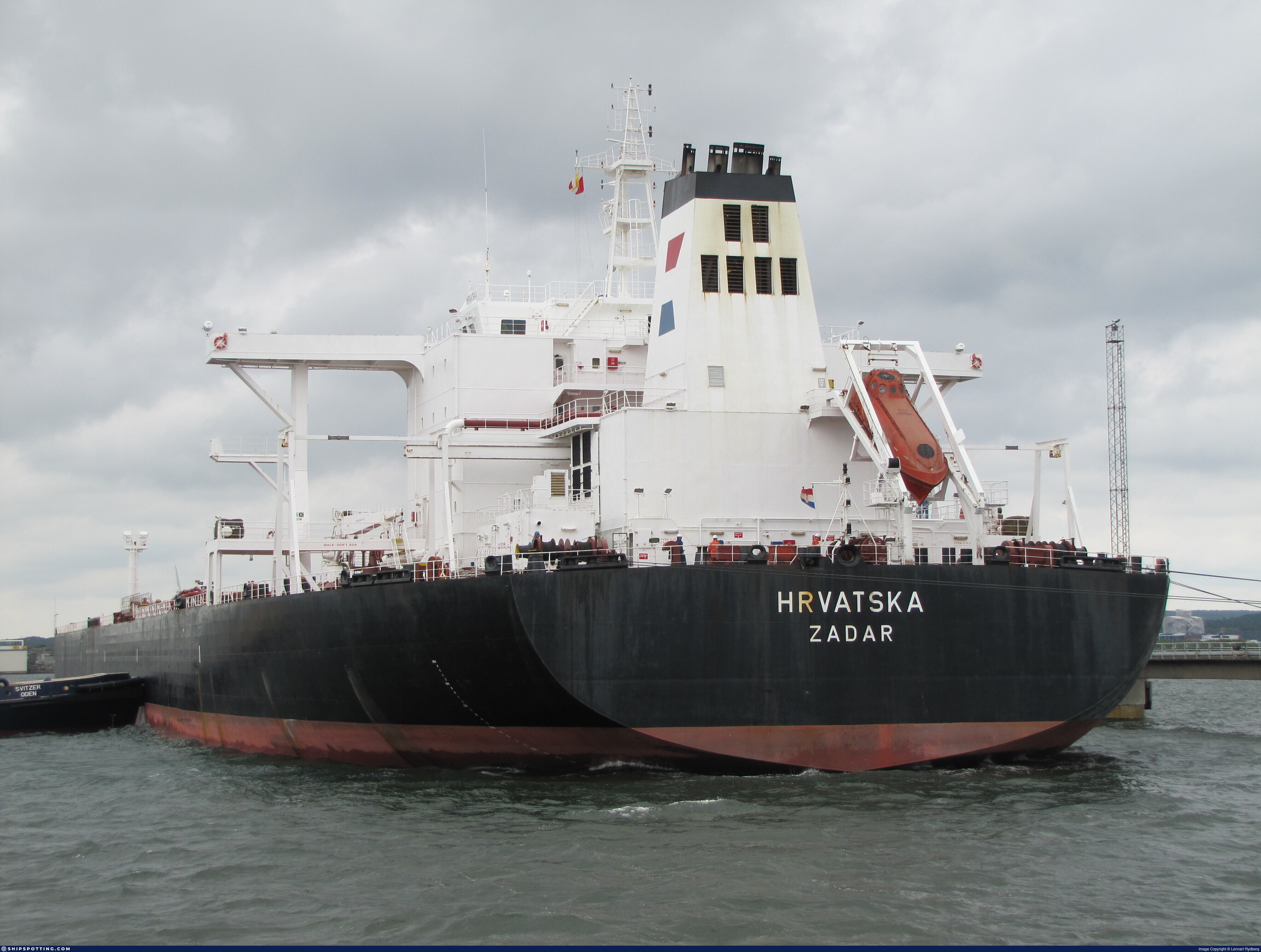
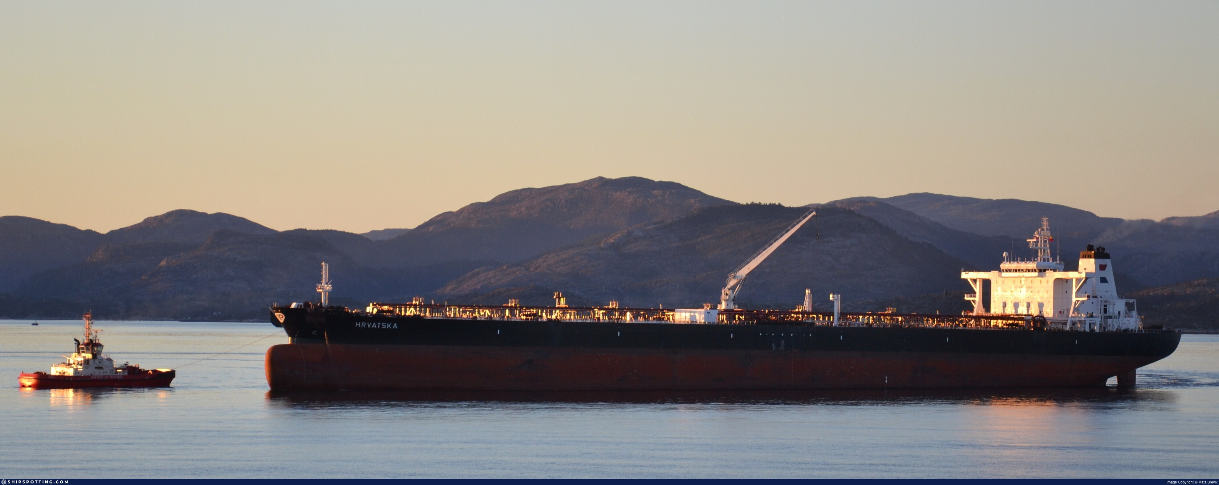
IMO 9249087
Vessel information
Sanctioned by
Company & Ownership
Management & Operations
Port State Control (PSC) Inspections
Programs & Notes
SEMA (Canada) — vessel designations | RUSSIA-EO14024 | The Russia (Sanctions) (EU Exit) Regulations 2019
Secondary sanctions risk: See Section 11 of Executive Order 14024.; Vessel Registration Identification IMO 9249087; MMSI 636018127; Linked To: HENNESEA HOLDINGS LIMITED. || DateDesignated: 2025-09-12 | Shipping sanctions: (see “Other information”) | Shipping sanctions: a specified ship is prohibited from being provided with access to or having its master or pilot cause it to enter a port in the UK, may have its registration on the UK Ship Register terminated, and a master or pilot of a specified ship may be given a port barring direction, a detention direction, and a port entry direction or a movement direction. | IMO 9249087 (HS GLORY) is, has been or is likely to be involved in activity whose object or effect is to destabilise Ukraine or undermine or threaten the territorial integrity, sovereignty or independence of Ukraine or to obtain a benefit from or support the Government of Russia. Namely, HS GLORY is involved in carrying oil or oil products that originated in Russia from Russia to a third country.
Vessel Changes
 🔄 Owner
AIS Events
18 events detected • 2 zones • Last: Jun 16, 2026
- Zone: Northern Baltic Sea Surveillance Zone
- Duration: 3h 36m
- Data Points: 10 AIS positions
- Period: 2026-06-16T11:06:13+00:00 to 2026-06-16T14:42:35+00:00
Show Raw Evidence JSON
{
    "zone_id": "discovered_036",
    "zone_name": "Northern Baltic Sea Surveillance Zone",
    "dwell_minutes": 216.400000000000005684341886080801486968994140625,
    "points_in_zone": 10,
    "first_point": {
        "ts": "2026-06-16T11:06:13+00:00",
        "lat": 36.00047500000000155750967678613960742950439453125,
        "lon": 130.98215329999999312349245883524417877197265625
    },
    "last_point": {
        "ts": "2026-06-16T14:42:35+00:00",
        "lat": 36.0104867000000012922100722789764404296875,
        "lon": 130.939294999999987112460075877606868743896484375
    }
}- Zone: Northern Baltic Sea Surveillance Zone
- Duration: 1h 6m
- Data Points: 13 AIS positions
- Period: 2026-06-12T09:20:14+00:00 to 2026-06-12T10:26:46+00:00
Show Raw Evidence JSON
{
    "zone_id": "discovered_036",
    "zone_name": "Northern Baltic Sea Surveillance Zone",
    "dwell_minutes": 66.5,
    "points_in_zone": 13,
    "first_point": {
        "ts": "2026-06-12T09:20:14+00:00",
        "lat": 36.02170000000000271711542154662311077117919921875,
        "lon": 130.78343499999999721694621257483959197998046875
    },
    "last_point": {
        "ts": "2026-06-12T10:26:46+00:00",
        "lat": 36.032246700000001737862476147711277008056640625,
        "lon": 130.786245000000008076312951743602752685546875
    }
}- Duration: 2h 14m
- Radius: 1,034 meters
- Data Points: 19 AIS positions
- Centroid: 36.0236, 130.7852
- Zone: Northern Baltic Sea Surveillance Zone
Show Raw Evidence JSON
{
    "radius_m": 1034,
    "duration_minutes": 134.19999999999998863131622783839702606201171875,
    "points": 19,
    "centroid": {
        "lat": 36.0235750894736810323593090288341045379638671875,
        "lon": 130.7852485894736673799343407154083251953125
    },
    "bbox": {
        "min_lat": 36.014544999999998253770172595977783203125,
        "min_lon": 130.78307499999999663486960344016551971435546875,
        "max_lat": 36.032246700000001737862476147711277008056640625,
        "max_lon": 130.788083300000010922303772531449794769287109375
    },
    "zone_id": "discovered_036"
}- Zone: Northern Baltic Sea Surveillance Zone
- Duration: 2h 26m
- Data Points: 23 AIS positions
- Period: 2026-06-12T08:00:15+00:00 to 2026-06-12T10:26:46+00:00
Show Raw Evidence JSON
{
    "zone_id": "discovered_036",
    "zone_name": "Northern Baltic Sea Surveillance Zone",
    "dwell_minutes": 146.5,
    "points_in_zone": 23,
    "first_point": {
        "ts": "2026-06-12T08:00:15+00:00",
        "lat": 36.01325669999999945503077469766139984130859375,
        "lon": 130.7893100000000004001776687800884246826171875
    },
    "last_point": {
        "ts": "2026-06-12T10:26:46+00:00",
        "lat": 36.032246700000001737862476147711277008056640625,
        "lon": 130.786245000000008076312951743602752685546875
    }
}- Duration: 2h 10m
- Radius: 1,139 meters
- Data Points: 20 AIS positions
- Centroid: 36.0179, 130.7867
- Zone: Northern Baltic Sea Surveillance Zone
Show Raw Evidence JSON
{
    "radius_m": 1138.5,
    "duration_minutes": 130.30000000000001136868377216160297393798828125,
    "points": 20,
    "centroid": {
        "lat": 36.0179250099999990197829902172088623046875,
        "lon": 130.786746910000005073015927337110042572021484375
    },
    "bbox": {
        "min_lat": 36.01241499999999717829268774949014186859130859375,
        "min_lon": 130.78307499999999663486960344016551971435546875,
        "max_lat": 36.02792000000000172121872310526669025421142578125,
        "max_lon": 130.790453299999995806501829065382480621337890625
    },
    "zone_id": "discovered_036"
}- Zone: Northern Baltic Sea Surveillance Zone
- Duration: 2h 41m
- Data Points: 27 AIS positions
- Period: 2026-06-12T07:45:37+00:00 to 2026-06-12T10:26:46+00:00
Show Raw Evidence JSON
{
    "zone_id": "discovered_036",
    "zone_name": "Northern Baltic Sea Surveillance Zone",
    "dwell_minutes": 161.19999999999998863131622783839702606201171875,
    "points_in_zone": 27,
    "first_point": {
        "ts": "2026-06-12T07:45:37+00:00",
        "lat": 36.01198670000000134905349113978445529937744140625,
        "lon": 130.791120000000006484697223640978336334228515625
    },
    "last_point": {
        "ts": "2026-06-12T10:26:46+00:00",
        "lat": 36.032246700000001737862476147711277008056640625,
        "lon": 130.786245000000008076312951743602752685546875
    }
}- Duration: 1h 37m
- Radius: 1,131 meters
- Data Points: 19 AIS positions
- Centroid: 35.9513, 130.6089
- Zone: Northern Baltic Sea Surveillance Zone
Show Raw Evidence JSON
{
    "radius_m": 1130.5,
    "duration_minutes": 97.5,
    "points": 19,
    "centroid": {
        "lat": 35.95126562631579503204193315468728542327880859375,
        "lon": 130.608885347368442353399586863815784454345703125
    },
    "bbox": {
        "min_lat": 35.95087170000000043046384234912693500518798828125,
        "min_lon": 130.598534999999998262865119613707065582275390625,
        "max_lat": 35.95167670000000015306795830838382244110107421875,
        "max_lon": 130.62141500000001315129338763654232025146484375
    },
    "zone_id": "discovered_036"
}- Zone: Northern Baltic Sea Surveillance Zone
- Duration: 1h 37m
- Data Points: 19 AIS positions
- Period: 2026-06-05T06:17:26+00:00 to 2026-06-05T07:54:59+00:00
Show Raw Evidence JSON
{
    "zone_id": "discovered_036",
    "zone_name": "Northern Baltic Sea Surveillance Zone",
    "dwell_minutes": 97.5,
    "points_in_zone": 19,
    "first_point": {
        "ts": "2026-06-05T06:17:26+00:00",
        "lat": 35.95087170000000043046384234912693500518798828125,
        "lon": 130.598534999999998262865119613707065582275390625
    },
    "last_point": {
        "ts": "2026-06-05T07:54:59+00:00",
        "lat": 35.95140169999999812944224686361849308013916015625,
        "lon": 130.62141500000001315129338763654232025146484375
    }
}- Minimum Distance: 40 meters
- Average Distance: 44 meters
- Duration: 33 minutes
- Period: 2026-02-07T23:58:05+00:00 to 2026-02-08T00:31:07+00:00
- Vessel A Avg Speed: 0.1 knots
- Vessel B Avg Speed: 0.0 knots
- Zone: Baltic Sea Surveillance Zone
Confidence Analysis
Moderate-confidence STS candidate. Two tankers (DRACO and LIDER) maintained close proximity (min 40m, avg 44m) for 33 minutes. Both vessels were slow-moving (avg speeds 0.1 and 0.0 knots). The stable separation distance suggests deliberate parallel positioning typical of cargo transfer. Event occurred in Delta of the Nile Monitoring Zone, a known STS activity area.
View scoring breakdown
| Factor | Score | Detail |
|---|---|---|
| Distance Tightness | 25/25 | Min distance 40m, avg 44m |
| Duration | 5/25 | Duration 33 minutes |
| Speed Stability | 20/20 | both nearly stationary; very stable speeds |
| Distance Consistency | 15/15 | Distance variance ±4m |
| Isolation | 5/10 | Isolation data not available |
| Context | 5/5 | In monitored zone: Delta of the Nile Monitoring Zone |
🛰️ Satellite Corroboration
No satellite imagery for this time/location
No Sentinel-1 scenes covering AOI and time window
Show Raw Evidence JSON
{
    "vessel_a": {
        "mmsi": 632001118,
        "imo": 9249087,
        "name": "DRACO",
        "flag": "GUINEA"
    },
    "vessel_b": {
        "mmsi": 273273450,
        "imo": 9321706,
        "name": "LIDER",
        "flag": "RUSSIA"
    },
    "min_distance_m": 40.39999999999999857891452847979962825775146484375,
    "avg_distance_m": 43.7999999999999971578290569595992565155029296875,
    "distance_consistency_m": 3.79999999999999982236431605997495353221893310546875,
    "duration_minutes": 33,
    "overlap_duration_s": 1982,
    "speed_a_avg": 0.05000000000000000277555756156289135105907917022705078125,
    "speed_a_std": 0.05000000000000000277555756156289135105907917022705078125,
    "speed_b_avg": 0,
    "speed_b_std": 0,
    "speed_summary": {
        "vessel_a": {
            "avg_sog": 0.05000000000000000277555756156289135105907917022705078125,
            "max_sog": 0.1000000000000000055511151231257827021181583404541015625
        },
        "vessel_b": {
            "avg_sog": 0,
            "max_sog": 0
        }
    },
    "time_window": {
        "start": "2026-02-07T23:58:05+00:00",
        "end": "2026-02-08T00:31:07+00:00"
    },
    "points_count": {
        "vessel_a": 6,
        "vessel_b": 6
    },
    "zone_id": "discovered_015",
    "zone_name": "Delta of the Nile Monitoring Zone",
    "score": {
        "value": 75,
        "components": {
            "distance_tightness": {
                "score": 25,
                "max": 25,
                "detail": "Min distance 40m, avg 44m"
            },
            "duration": {
                "score": 5,
                "max": 25,
                "detail": "Duration 33 minutes"
            },
            "speed_stability": {
                "score": 20,
                "max": 20,
                "detail": "both nearly stationary; very stable speeds"
            },
            "distance_consistency": {
                "score": 15,
                "max": 15,
                "detail": "Distance variance \u00b14m"
            },
            "isolation": {
                "score": 5,
                "max": 10,
                "detail": "Isolation data not available"
            },
            "context": {
                "score": 5,
                "max": 5,
                "detail": "In monitored zone: Delta of the Nile Monitoring Zone"
            }
        },
        "summary": "Moderate-confidence STS candidate. Two tankers (DRACO and LIDER) maintained close proximity (min 40m, avg 44m) for 33 minutes. Both vessels were slow-moving (avg speeds 0.1 and 0.0 knots). The stable separation distance suggests deliberate parallel positioning typical of cargo transfer. Event occurred in Delta of the Nile Monitoring Zone, a known STS activity area."
    },
    "sar": {
        "status": "not_found",
        "centroid": {
            "lat": 31.532037599999998889188645989634096622467041015625,
            "lon": 32.302311000000003105014911852777004241943359375
        },
        "time_window": {
            "start_ts": "2026-02-07T23:58:05+00:00",
            "end_ts": "2026-02-08T00:31:07+00:00"
        },
        "searched_at": "2026-02-08T01:15:21.464306+00:00",
        "notes": "No Sentinel-1 scenes covering AOI and time window"
    }
}- Duration: 1h 48m
- Radius: 82 meters
- Data Points: 20 AIS positions
- Centroid: 31.5316, 32.3025
- Zone: Baltic Sea Surveillance Zone
Show Raw Evidence JSON
{
    "radius_m": 81.7000000000000028421709430404007434844970703125,
    "duration_minutes": 108,
    "points": 20,
    "centroid": {
        "lat": 31.531614830000012972277545486576855182647705078125,
        "lon": 32.3025470900000044593980419449508190155029296875
    },
    "bbox": {
        "min_lat": 31.530885000000001383568815072067081928253173828125,
        "min_lon": 32.3023850000000010140865924768149852752685546875,
        "max_lat": 31.532043300000001551097739138640463352203369140625,
        "max_lon": 32.302711700000003247623681090772151947021484375
    },
    "zone_id": "discovered_015"
}- Zone: Baltic Sea Surveillance Zone
- Duration: 1h 48m
- Data Points: 20 AIS positions
- Period: 2026-02-07T23:01:04+00:00 to 2026-02-08T00:49:05+00:00
Show Raw Evidence JSON
{
    "zone_id": "discovered_015",
    "zone_name": "Delta of the Nile Monitoring Zone",
    "dwell_minutes": 108,
    "points_in_zone": 20,
    "first_point": {
        "ts": "2026-02-07T23:01:04+00:00",
        "lat": 31.530885000000001383568815072067081928253173828125,
        "lon": 32.302666700000003174864104948937892913818359375
    },
    "last_point": {
        "ts": "2026-02-08T00:49:05+00:00",
        "lat": 31.531954999999999955662133288569748401641845703125,
        "lon": 32.3024199999999979127096594311296939849853515625
    }
}- Duration: 2h 27m
- Radius: 66 meters
- Data Points: 25 AIS positions
- Centroid: 31.5315, 32.3026
- Zone: Baltic Sea Surveillance Zone
Show Raw Evidence JSON
{
    "radius_m": 66.400000000000005684341886080801486968994140625,
    "duration_minutes": 147.099999999999994315658113919198513031005859375,
    "points": 25,
    "centroid": {
        "lat": 31.53147832800001282294033444486558437347412109375,
        "lon": 32.3025713439999861975593375973403453826904296875
    },
    "bbox": {
        "min_lat": 31.530885000000001383568815072067081928253173828125,
        "min_lon": 32.3023850000000010140865924768149852752685546875,
        "max_lat": 31.532043300000001551097739138640463352203369140625,
        "max_lon": 32.302711700000003247623681090772151947021484375
    },
    "zone_id": "discovered_015"
}- Zone: Baltic Sea Surveillance Zone
- Duration: 2h 27m
- Data Points: 25 AIS positions
- Period: 2026-02-07T22:22:02+00:00 to 2026-02-08T00:49:05+00:00
Show Raw Evidence JSON
{
    "zone_id": "discovered_015",
    "zone_name": "Delta of the Nile Monitoring Zone",
    "dwell_minutes": 147.099999999999994315658113919198513031005859375,
    "points_in_zone": 25,
    "first_point": {
        "ts": "2026-02-07T22:22:02+00:00",
        "lat": 31.530938299999998974953996366821229457855224609375,
        "lon": 32.302666700000003174864104948937892913818359375
    },
    "last_point": {
        "ts": "2026-02-08T00:49:05+00:00",
        "lat": 31.531954999999999955662133288569748401641845703125,
        "lon": 32.3024199999999979127096594311296939849853515625
    }
}- Duration: 4h 24m
- Radius: 76 meters
- Data Points: 27 AIS positions
- Centroid: 31.5314, 32.3026
- Zone: Baltic Sea Surveillance Zone
Show Raw Evidence JSON
{
    "radius_m": 75.5,
    "duration_minutes": 264,
    "points": 27,
    "centroid": {
        "lat": 31.531432033333341991010456695221364498138427734375,
        "lon": 32.30258155185185131585967610590159893035888671875
    },
    "bbox": {
        "min_lat": 31.5307600000000007867129170335829257965087890625,
        "min_lon": 32.3023850000000010140865924768149852752685546875,
        "max_lat": 31.532043300000001551097739138640463352203369140625,
        "max_lon": 32.302711700000003247623681090772151947021484375
    },
    "zone_id": "discovered_015"
}- Zone: Baltic Sea Surveillance Zone
- Duration: 4h 24m
- Data Points: 27 AIS positions
- Period: 2026-02-07T20:25:03+00:00 to 2026-02-08T00:49:05+00:00
Show Raw Evidence JSON
{
    "zone_id": "discovered_015",
    "zone_name": "Delta of the Nile Monitoring Zone",
    "dwell_minutes": 264,
    "points_in_zone": 27,
    "first_point": {
        "ts": "2026-02-07T20:25:03+00:00",
        "lat": 31.5307600000000007867129170335829257965087890625,
        "lon": 32.30270999999999759211277705617249011993408203125
    },
    "last_point": {
        "ts": "2026-02-08T00:49:05+00:00",
        "lat": 31.531954999999999955662133288569748401641845703125,
        "lon": 32.3024199999999979127096594311296939849853515625
    }
}- Gap Duration: 4h 14m
- Last Seen: 2026-02-07T16:10:27+00:00 at 31.5653, 32.2295 (Zone: Baltic Sea Surveillance Zone)
- Next Seen: 2026-02-07T20:25:03+00:00 at 31.5308, 32.3027
🛰️ Gap Corroboration
These are snapshots that may corroborate presence during the gap. They do not reconstruct a continuous route.
SAR Imagery (Sentinel-1)
Status: ✗ No SAR coverage
No Sentinel-1 scenes covering corridor and time window
VIIRS Thermal Anomaly
Status: ✗ No detections
No VIIRS thermal/light detections in corridor
Show Raw Evidence JSON
{
    "gap_minutes": 254.599999999999994315658113919198513031005859375,
    "last_seen": {
        "ts": "2026-02-07T16:10:27+00:00",
        "lat": 31.565336699999999581223164568655192852020263671875,
        "lon": 32.22951669999999779747668071649968624114990234375,
        "sog": 5.70000000000000017763568394002504646778106689453125,
        "zone_id": "discovered_015"
    },
    "next_seen": {
        "ts": "2026-02-07T20:25:03+00:00",
        "lat": 31.5307600000000007867129170335829257965087890625,
        "lon": 32.30270999999999759211277705617249011993408203125,
        "zone_ids": [
            "discovered_015"
        ]
    },
    "gap_enrichment": {
        "status": "not_found",
        "corridor": {
            "start": {
                "lat": 31.565336699999999581223164568655192852020263671875,
                "lon": 32.22951669999999779747668071649968624114990234375,
                "ts": "2026-02-07T16:10:27+00:00"
            },
            "end": {
                "lat": 31.5307600000000007867129170335829257965087890625,
                "lon": 32.30270999999999759211277705617249011993408203125,
                "ts": "2026-02-07T20:25:03+00:00"
            },
            "bbox": {
                "min_lat": 31.35058000000000077989170677028596401214599609375,
                "min_lon": 32.01808799999999877172740525566041469573974609375,
                "max_lat": 31.74551699999999954115992295555770397186279296875,
                "max_lon": 32.5141390000000001236912794411182403564453125
            },
            "buffer_km": 20
        },
        "sar": {
            "status": "not_found",
            "notes": "No Sentinel-1 scenes covering corridor and time window"
        },
        "viirs": {
            "status": "not_found",
            "notes": "No VIIRS thermal\/light detections in corridor"
        },
        "searched_at": "2026-02-07T20:45:13.836392+00:00"
    }
}- Zone: Baltic Sea Surveillance Zone
- Duration: 6h 32m
- Data Points: 7 AIS positions
- Period: 2026-02-07T16:10:27+00:00 to 2026-02-07T22:43:04+00:00
Show Raw Evidence JSON
{
    "zone_id": "discovered_015",
    "zone_name": "Delta of the Nile Monitoring Zone",
    "dwell_minutes": 392.6000000000000227373675443232059478759765625,
    "points_in_zone": 7,
    "first_point": {
        "ts": "2026-02-07T16:10:27+00:00",
        "lat": 31.565336699999999581223164568655192852020263671875,
        "lon": 32.22951669999999779747668071649968624114990234375
    },
    "last_point": {
        "ts": "2026-02-07T22:43:04+00:00",
        "lat": 31.53091500000000024783730623312294483184814453125,
        "lon": 32.3026399999999966894392855465412139892578125
    }
}- Zone: Baltic Sea Surveillance Zone
- Duration: 6h 34m
- Data Points: 10 AIS positions
- Period: 2026-02-07T15:50:57+00:00 to 2026-02-07T22:25:04+00:00
Show Raw Evidence JSON
{
    "zone_id": "discovered_015",
    "zone_name": "Delta of the Nile Monitoring Zone",
    "dwell_minutes": 394.1000000000000227373675443232059478759765625,
    "points_in_zone": 10,
    "first_point": {
        "ts": "2026-02-07T15:50:57+00:00",
        "lat": 31.5899332999999984394889906980097293853759765625,
        "lon": 32.2098016999999998688508640043437480926513671875
    },
    "last_point": {
        "ts": "2026-02-07T22:25:04+00:00",
        "lat": 31.53096000000000032059688237495720386505126953125,
        "lon": 32.3027067000000016605554264970123767852783203125
    }
}Source snapshot
| Sanctioner | As of | Entity ID |
|---|---|---|
| 🇬🇧 UK | 2025-09-29 | 9249087 |
| 🇺🇸 US | 2025-09-29 | 9249087 |
We mirror official lists; always verify at the source.
Sanctioned on the same day
- ADMIRAL · IMO 9274446 🇨🇦 CA🇬🇧 UK🇺🇸 US
- AKCENT · IMO 9381732 🇨🇦 CA🇪🇺 EU🇬🇧 UK🇺🇸 US
- AKHILL · IMO 9410870 🇨🇦 CA🇬🇧 UK🇺🇸 US
- AKKORD · IMO 9259599 🇨🇦 CA🇬🇧 UK🇺🇸 US
- AKSEL · IMO 9410894 🇨🇦 CA🇬🇧 UK🇺🇸 US
- ALGORITM · IMO 9299745 🇨🇦 CA🇬🇧 UK🇺🇸 US
- ALYSSUM · IMO 9314818 🇨🇦 CA🇬🇧 UK🇺🇸 US
- ANEMON · IMO 9323338 🇨🇦 CA🇬🇧 UK🇺🇸 US