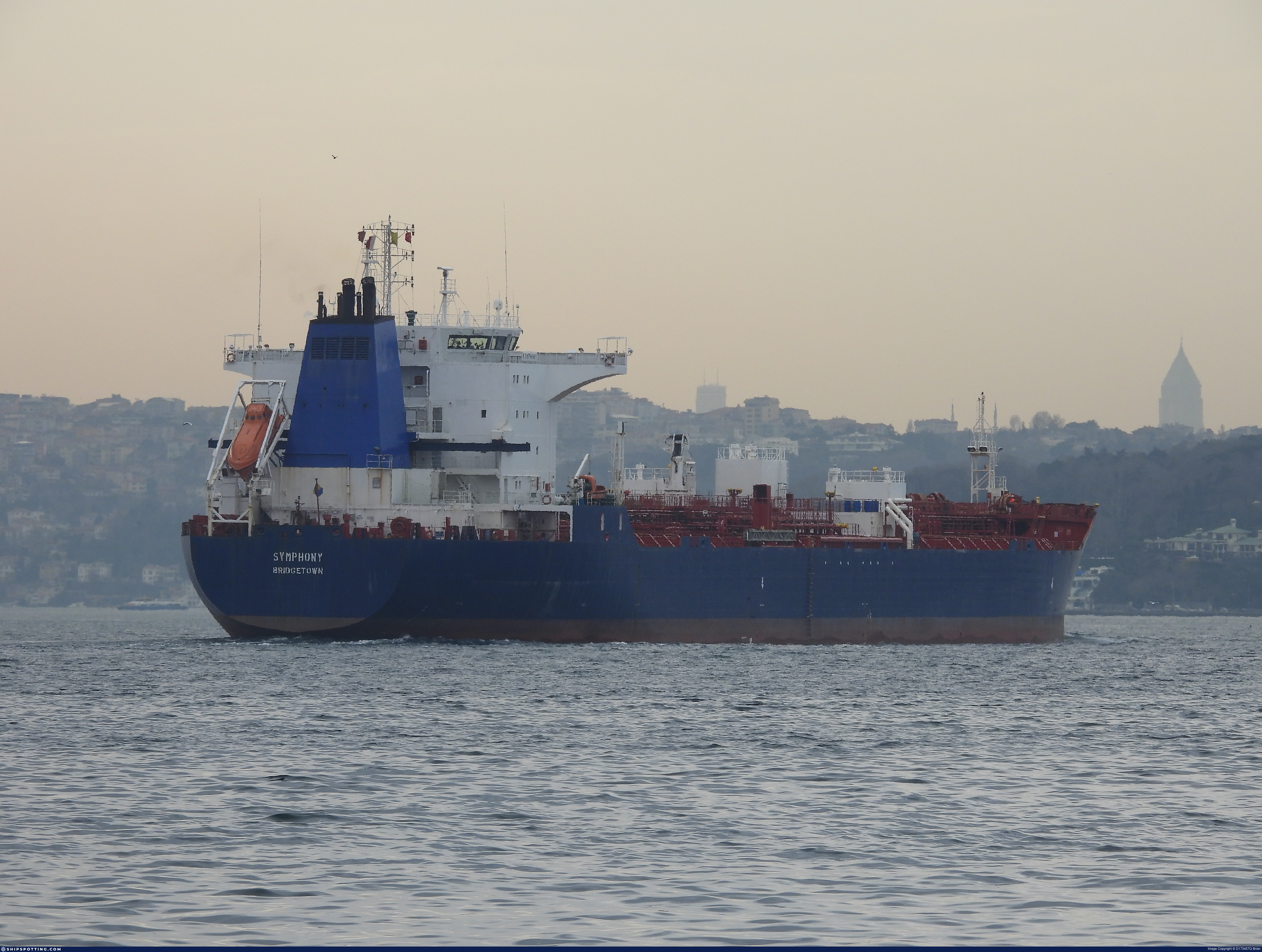
IMO 9309588
Vessel information
Sanctioned by
Company & Ownership
Management & Operations
Classification & Safety
Port State Control (PSC) Inspections
Survey Renewal & Certificates
| Code | Type | Issuer | Issued | Expires |
|---|---|---|---|---|
| 510 | Safety Management Certificate | Indian Register of Shipping (150) | 08/07/2024 | 01/07/2029 |
| 512 | Minimum Safe Manning Document | Gabon (GA) | 18/06/2024 | 02/06/2029 |
Programs & Notes
EU Russia Sanctions – Shadow Fleet | SEMA (Canada) — vessel designations | UKRAINE-EO13662] [RUSSIA-EO14024 | The Russia (Sanctions) (EU Exit) Regulations 2019
DateOfListing: 2025-02-25 || Secondary sanctions risk: See Section 11 of Executive Order 14024.; alt. Secondary sanctions risk: Ukraine-/Russia-Related Sanctions Regulations, 31 CFR 589.201 and/or 589.209; Vessel Registration Identification IMO 9309588; MMSI 314947000; Linked To: FORNAX SHIP MANAGEMENT FZCO. || DateDesignated: 2025-07-21 | Shipping sanctions: (see “Other information”) | Shipping sanctions: a specified ship is prohibited from being provided with access to or having its master or pilot cause it to enter a port in the UK, may have its registration on the UK Ship Register terminated, and a master or pilot of a specified ship may be given a port barring direction, a detention direction, and a port entry direction or a movement direction. | IMO 9309588 (“Symphony”) is, has been or is likely to be involved in activity whose object or effect is to destabilise Ukraine or undermine or threaten the territorial integrity, sovereignty or independence of Ukraine or to obtain a benefit from or support the Government of Russia. Namely, 9309588 is involved in carrying oil or oil products that originated in Russia from Russia to a third country.
Vessel Changes
AIS Events
50 events detected • 2 zones • Last: Mar 18, 2026
- Zone: Central Atlantic Surveillance Zone
- Duration: 1h 31m
- Data Points: 16 AIS positions
- Period: 2026-03-18T12:00:33+00:00 to 2026-03-18T13:31:31+00:00
Show Raw Evidence JSON
{
    "zone_id": "discovered_014",
    "zone_name": "Western Pomerania Monitoring Zone",
    "dwell_minutes": 91,
    "points_in_zone": 16,
    "first_point": {
        "ts": "2026-03-18T12:00:33+00:00",
        "lat": 31.611553300000000632508090347982943058013916015625,
        "lon": 32.2623882999999977982952259480953216552734375
    },
    "last_point": {
        "ts": "2026-03-18T13:31:31+00:00",
        "lat": 31.60197000000000144837031257338821887969970703125,
        "lon": 32.2478966999999983045199769549071788787841796875
    }
}- Duration: 1h 58m
- Radius: 1,117 meters
- Data Points: 24 AIS positions
- Centroid: 31.6109, 32.2626
- Zone: Central Atlantic Surveillance Zone
Show Raw Evidence JSON
{
    "radius_m": 1117.40000000000009094947017729282379150390625,
    "duration_minutes": 118.400000000000005684341886080801486968994140625,
    "points": 24,
    "centroid": {
        "lat": 31.610903812500009024688552017323672771453857421875,
        "lon": 32.26257764166666675009764730930328369140625
    },
    "bbox": {
        "min_lat": 31.601213300000001282796802115626633167266845703125,
        "min_lon": 32.25509670000000284062480204738676548004150390625,
        "max_lat": 31.61512499999999903366187936626374721527099609375,
        "max_lon": 32.26615000000000321733750752173364162445068359375
    },
    "zone_id": "discovered_014"
}- Zone: Central Atlantic Surveillance Zone
- Duration: 2h 2m
- Data Points: 26 AIS positions
- Period: 2026-03-18T11:28:54+00:00 to 2026-03-18T13:31:31+00:00
Show Raw Evidence JSON
{
    "zone_id": "discovered_014",
    "zone_name": "Western Pomerania Monitoring Zone",
    "dwell_minutes": 122.599999999999994315658113919198513031005859375,
    "points_in_zone": 26,
    "first_point": {
        "ts": "2026-03-18T11:28:54+00:00",
        "lat": 31.612905000000001365378921036608517169952392578125,
        "lon": 32.26411999999999835608832654543220996856689453125
    },
    "last_point": {
        "ts": "2026-03-18T13:31:31+00:00",
        "lat": 31.60197000000000144837031257338821887969970703125,
        "lon": 32.2478966999999983045199769549071788787841796875
    }
}- Duration: 3h 25m
- Radius: 1,050 meters
- Data Points: 29 AIS positions
- Centroid: 31.6103, 32.2629
- Zone: Central Atlantic Surveillance Zone
Show Raw Evidence JSON
{
    "radius_m": 1049.799999999999954525264911353588104248046875,
    "duration_minutes": 205.400000000000005684341886080801486968994140625,
    "points": 29,
    "centroid": {
        "lat": 31.610337468965521878772051422856748104095458984375,
        "lon": 32.26285655862069035038075526244938373565673828125
    },
    "bbox": {
        "min_lat": 31.601213300000001282796802115626633167266845703125,
        "min_lon": 32.25509670000000284062480204738676548004150390625,
        "max_lat": 31.61512499999999903366187936626374721527099609375,
        "max_lon": 32.26615000000000321733750752173364162445068359375
    },
    "zone_id": "discovered_014"
}- Zone: Central Atlantic Surveillance Zone
- Duration: 3h 29m
- Data Points: 31 AIS positions
- Period: 2026-03-18T10:01:54+00:00 to 2026-03-18T13:31:31+00:00
Show Raw Evidence JSON
{
    "zone_id": "discovered_014",
    "zone_name": "Western Pomerania Monitoring Zone",
    "dwell_minutes": 209.599999999999994315658113919198513031005859375,
    "points_in_zone": 31,
    "first_point": {
        "ts": "2026-03-18T10:01:54+00:00",
        "lat": 31.608064999999999855617716093547642230987548828125,
        "lon": 32.2660716999999976906110532581806182861328125
    },
    "last_point": {
        "ts": "2026-03-18T13:31:31+00:00",
        "lat": 31.60197000000000144837031257338821887969970703125,
        "lon": 32.2478966999999983045199769549071788787841796875
    }
}- Duration: 4h 3m
- Radius: 999 meters
- Data Points: 39 AIS positions
- Centroid: 31.6100, 32.2638
- Zone: Central Atlantic Surveillance Zone
Show Raw Evidence JSON
{
    "radius_m": 998.799999999999954525264911353588104248046875,
    "duration_minutes": 243.400000000000005684341886080801486968994140625,
    "points": 39,
    "centroid": {
        "lat": 31.61002153589743812744927708990871906280517578125,
        "lon": 32.263809456410257325842394493520259857177734375
    },
    "bbox": {
        "min_lat": 31.601213300000001282796802115626633167266845703125,
        "min_lon": 32.25509670000000284062480204738676548004150390625,
        "max_lat": 31.61717829999999906931407167576253414154052734375,
        "max_lon": 32.270201700000001210355549119412899017333984375
    },
    "zone_id": "discovered_014"
}- Zone: Central Atlantic Surveillance Zone
- Duration: 4h 19m
- Data Points: 46 AIS positions
- Period: 2026-03-18T09:11:44+00:00 to 2026-03-18T13:31:31+00:00
Show Raw Evidence JSON
{
    "zone_id": "discovered_014",
    "zone_name": "Western Pomerania Monitoring Zone",
    "dwell_minutes": 259.80000000000001136868377216160297393798828125,
    "points_in_zone": 46,
    "first_point": {
        "ts": "2026-03-18T09:11:44+00:00",
        "lat": 31.60282169999999979381755110807716846466064453125,
        "lon": 32.265258299999999280771589837968349456787109375
    },
    "last_point": {
        "ts": "2026-03-18T13:31:31+00:00",
        "lat": 31.60197000000000144837031257338821887969970703125,
        "lon": 32.2478966999999983045199769549071788787841796875
    }
}- Zone: Central Atlantic Surveillance Zone
- Duration: 5h 30m
- Data Points: 51 AIS positions
- Period: 2026-03-18T08:01:03+00:00 to 2026-03-18T13:31:31+00:00
Show Raw Evidence JSON
{
    "zone_id": "discovered_014",
    "zone_name": "Western Pomerania Monitoring Zone",
    "dwell_minutes": 330.5,
    "points_in_zone": 51,
    "first_point": {
        "ts": "2026-03-18T08:01:03+00:00",
        "lat": 31.60580829999999963320078677497804164886474609375,
        "lon": 32.26322499999999848796505830250680446624755859375
    },
    "last_point": {
        "ts": "2026-03-18T13:31:31+00:00",
        "lat": 31.60197000000000144837031257338821887969970703125,
        "lon": 32.2478966999999983045199769549071788787841796875
    }
}- Duration: 1h 59m
- Radius: 637 meters
- Data Points: 13 AIS positions
- Centroid: 31.6047, 32.2635
- Zone: Central Atlantic Surveillance Zone
Show Raw Evidence JSON
{
    "radius_m": 637.1000000000000227373675443232059478759765625,
    "duration_minutes": 119.900000000000005684341886080801486968994140625,
    "points": 13,
    "centroid": {
        "lat": 31.60471232307691735741173033602535724639892578125,
        "lon": 32.26354127692308537689314107410609722137451171875
    },
    "bbox": {
        "min_lat": 31.6027966999999989639036357402801513671875,
        "min_lon": 32.25683000000000077989170677028596401214599609375,
        "max_lat": 31.608643300000000664340404910035431385040283203125,
        "max_lon": 32.26705170000000322261257679201662540435791015625
    },
    "zone_id": "discovered_014"
}- Zone: Central Atlantic Surveillance Zone
- Duration: 6h 8m
- Data Points: 54 AIS positions
- Period: 2026-03-18T07:23:00+00:00 to 2026-03-18T13:31:31+00:00
Show Raw Evidence JSON
{
    "zone_id": "discovered_014",
    "zone_name": "Western Pomerania Monitoring Zone",
    "dwell_minutes": 368.5,
    "points_in_zone": 54,
    "first_point": {
        "ts": "2026-03-18T07:23:00+00:00",
        "lat": 31.608643300000000664340404910035431385040283203125,
        "lon": 32.25965169999999915262378635816276073455810546875
    },
    "last_point": {
        "ts": "2026-03-18T13:31:31+00:00",
        "lat": 31.60197000000000144837031257338821887969970703125,
        "lon": 32.2478966999999983045199769549071788787841796875
    }
}- Duration: 6h 7m
- Radius: 563 meters
- Data Points: 12 AIS positions
- Centroid: 31.6061, 32.2615
- Zone: Central Atlantic Surveillance Zone
Show Raw Evidence JSON
{
    "radius_m": 563.3999999999999772626324556767940521240234375,
    "duration_minutes": 367.19999999999998863131622783839702606201171875,
    "points": 12,
    "centroid": {
        "lat": 31.6061370833333370455875410698354244232177734375,
        "lon": 32.2614750166666652830826933495700359344482421875
    },
    "bbox": {
        "min_lat": 31.60110999999999847887011128477752208709716796875,
        "min_lon": 32.25683000000000077989170677028596401214599609375,
        "max_lat": 31.610150000000000858335624798201024532318115234375,
        "max_lon": 32.26705170000000322261257679201662540435791015625
    },
    "zone_id": "discovered_014"
}- Zone: Central Atlantic Surveillance Zone
- Duration: 6h 7m
- Data Points: 12 AIS positions
- Period: 2026-03-18T02:02:49+00:00 to 2026-03-18T08:10:04+00:00
Show Raw Evidence JSON
{
    "zone_id": "discovered_014",
    "zone_name": "Western Pomerania Monitoring Zone",
    "dwell_minutes": 367.19999999999998863131622783839702606201171875,
    "points_in_zone": 12,
    "first_point": {
        "ts": "2026-03-18T02:02:49+00:00",
        "lat": 31.60633500000000140062184073030948638916015625,
        "lon": 32.25708499999999645524439984001219272613525390625
    },
    "last_point": {
        "ts": "2026-03-18T08:10:04+00:00",
        "lat": 31.60398169999999851143002160824835300445556640625,
        "lon": 32.26431170000000037134668673388659954071044921875
    }
}- Duration: 5h 14m
- Radius: 815 meters
- Data Points: 10 AIS positions
- Centroid: 31.6081, 32.2595
- Zone: Central Atlantic Surveillance Zone
Show Raw Evidence JSON
{
    "radius_m": 815.299999999999954525264911353588104248046875,
    "duration_minutes": 314.5,
    "points": 10,
    "centroid": {
        "lat": 31.608063659999999117644620127975940704345703125,
        "lon": 32.2595440099999990479773259721696376800537109375
    },
    "bbox": {
        "min_lat": 31.60110999999999847887011128477752208709716796875,
        "min_lon": 32.25708499999999645524439984001219272613525390625,
        "max_lat": 31.610150000000000858335624798201024532318115234375,
        "max_lon": 32.26233669999999875699359108693897724151611328125
    },
    "zone_id": "discovered_014"
}- Zone: Central Atlantic Surveillance Zone
- Duration: 5h 14m
- Data Points: 10 AIS positions
- Period: 2026-03-17T21:05:40+00:00 to 2026-03-18T02:20:08+00:00
Show Raw Evidence JSON
{
    "zone_id": "discovered_014",
    "zone_name": "Western Pomerania Monitoring Zone",
    "dwell_minutes": 314.5,
    "points_in_zone": 10,
    "first_point": {
        "ts": "2026-03-17T21:05:40+00:00",
        "lat": 31.60898999999999858800947549752891063690185546875,
        "lon": 32.25960669999999907986421021632850170135498046875
    },
    "last_point": {
        "ts": "2026-03-18T02:20:08+00:00",
        "lat": 31.60889829999999989240677678026258945465087890625,
        "lon": 32.25965169999999915262378635816276073455810546875
    }
}- Duration: 5h 47m
- Radius: 859 meters
- Data Points: 17 AIS positions
- Centroid: 31.6085, 32.2595
- Zone: Central Atlantic Surveillance Zone
Show Raw Evidence JSON
{
    "radius_m": 859,
    "duration_minutes": 347.8999999999999772626324556767940521240234375,
    "points": 17,
    "centroid": {
        "lat": 31.60846058823529602932467241771519184112548828125,
        "lon": 32.25947902941175726709843729622662067413330078125
    },
    "bbox": {
        "min_lat": 31.60110999999999847887011128477752208709716796875,
        "min_lon": 32.25708499999999645524439984001219272613525390625,
        "max_lat": 31.610150000000000858335624798201024532318115234375,
        "max_lon": 32.26233669999999875699359108693897724151611328125
    },
    "zone_id": "discovered_014"
}- Zone: Central Atlantic Surveillance Zone
- Duration: 5h 47m
- Data Points: 17 AIS positions
- Period: 2026-03-17T20:32:15+00:00 to 2026-03-18T02:20:08+00:00
Show Raw Evidence JSON
{
    "zone_id": "discovered_014",
    "zone_name": "Western Pomerania Monitoring Zone",
    "dwell_minutes": 347.8999999999999772626324556767940521240234375,
    "points_in_zone": 17,
    "first_point": {
        "ts": "2026-03-17T20:32:15+00:00",
        "lat": 31.608908299999999513829607167281210422515869140625,
        "lon": 32.259489999999999554347596131265163421630859375
    },
    "last_point": {
        "ts": "2026-03-18T02:20:08+00:00",
        "lat": 31.60889829999999989240677678026258945465087890625,
        "lon": 32.25965169999999915262378635816276073455810546875
    }
}- Duration: 2h 46m
- Radius: 111 meters
- Data Points: 14 AIS positions
- Centroid: 31.6090, 32.2595
- Zone: Central Atlantic Surveillance Zone
Show Raw Evidence JSON
{
    "radius_m": 110.599999999999994315658113919198513031005859375,
    "duration_minutes": 166.5,
    "points": 14,
    "centroid": {
        "lat": 31.60899202857142853417826700024306774139404296875,
        "lon": 32.2595075071428567525799735449254512786865234375
    },
    "bbox": {
        "min_lat": 31.60855169999999958463376970030367374420166015625,
        "min_lon": 32.25840500000000332647687173448503017425537109375,
        "max_lat": 31.60931670000000082154656411148607730865478515625,
        "max_lon": 32.25991669999999800211298861540853977203369140625
    },
    "zone_id": "discovered_014"
}- Zone: Central Atlantic Surveillance Zone
- Duration: 2h 46m
- Data Points: 14 AIS positions
- Period: 2026-03-17T18:46:15+00:00 to 2026-03-17T21:32:45+00:00
Show Raw Evidence JSON
{
    "zone_id": "discovered_014",
    "zone_name": "Western Pomerania Monitoring Zone",
    "dwell_minutes": 166.5,
    "points_in_zone": 14,
    "first_point": {
        "ts": "2026-03-17T18:46:15+00:00",
        "lat": 31.60855169999999958463376970030367374420166015625,
        "lon": 32.25991669999999800211298861540853977203369140625
    },
    "last_point": {
        "ts": "2026-03-17T21:32:45+00:00",
        "lat": 31.609018299999998902194420224986970424652099609375,
        "lon": 32.25950830000000024710971047170460224151611328125
    }
}- Duration: 1h 36m
- Radius: 37 meters
- Data Points: 27 AIS positions
- Centroid: 31.6094, 32.2614
- Zone: Baltic Sea Surveillance Zone
Show Raw Evidence JSON
{
    "radius_m": 36.7999999999999971578290569595992565155029296875,
    "duration_minutes": 96,
    "points": 27,
    "centroid": {
        "lat": 31.609409374074079579486351576633751392364501953125,
        "lon": 32.26139956296295707716126344166696071624755859375
    },
    "bbox": {
        "min_lat": 31.609153299999999120473148650489747524261474609375,
        "min_lon": 32.26111829999999969231794239021837711334228515625,
        "max_lat": 31.6096016999999989138814271427690982818603515625,
        "max_lon": 32.26162000000000062982508097775280475616455078125
    },
    "zone_id": "discovered_015"
}- Zone: Baltic Sea Surveillance Zone
- Duration: 1h 36m
- Data Points: 27 AIS positions
- Period: 2026-02-16T16:04:06+00:00 to 2026-02-16T17:40:06+00:00
Show Raw Evidence JSON
{
    "zone_id": "discovered_015",
    "zone_name": "Delta of the Nile Monitoring Zone",
    "dwell_minutes": 96,
    "points_in_zone": 27,
    "first_point": {
        "ts": "2026-02-16T16:04:06+00:00",
        "lat": 31.609435000000001281250661122612655162811279296875,
        "lon": 32.26138999999999867895894567482173442840576171875
    },
    "last_point": {
        "ts": "2026-02-16T17:40:06+00:00",
        "lat": 31.60935500000000075715433922596275806427001953125,
        "lon": 32.2613750000000010231815394945442676544189453125
    }
}- Duration: 2h 33m
- Radius: 41 meters
- Data Points: 43 AIS positions
- Centroid: 31.6094, 32.2614
- Zone: Baltic Sea Surveillance Zone
Show Raw Evidence JSON
{
    "radius_m": 41.2999999999999971578290569595992565155029296875,
    "duration_minutes": 153,
    "points": 43,
    "centroid": {
        "lat": 31.609399218604647074926106142811477184295654296875,
        "lon": 32.26136604418605458022284437902271747589111328125
    },
    "bbox": {
        "min_lat": 31.609153299999999120473148650489747524261474609375,
        "min_lon": 32.26101330000000189102138392627239227294921875,
        "max_lat": 31.6096016999999989138814271427690982818603515625,
        "max_lon": 32.26162000000000062982508097775280475616455078125
    },
    "zone_id": "discovered_015"
}- Zone: Baltic Sea Surveillance Zone
- Duration: 2h 33m
- Data Points: 43 AIS positions
- Period: 2026-02-16T15:07:06+00:00 to 2026-02-16T17:40:06+00:00
Show Raw Evidence JSON
{
    "zone_id": "discovered_015",
    "zone_name": "Delta of the Nile Monitoring Zone",
    "dwell_minutes": 153,
    "points_in_zone": 43,
    "first_point": {
        "ts": "2026-02-16T15:07:06+00:00",
        "lat": 31.6094666999999986956026987172663211822509765625,
        "lon": 32.26144670000000047593857743777334690093994140625
    },
    "last_point": {
        "ts": "2026-02-16T17:40:06+00:00",
        "lat": 31.60935500000000075715433922596275806427001953125,
        "lon": 32.2613750000000010231815394945442676544189453125
    }
}- Zone: Baltic Sea Surveillance Zone
- Duration: 4h 58m
- Data Points: 3 AIS positions
- Period: 2026-02-08T23:01:14+00:00 to 2026-02-09T03:59:58+00:00
Show Raw Evidence JSON
{
    "zone_id": "discovered_015",
    "zone_name": "Delta of the Nile Monitoring Zone",
    "dwell_minutes": 298.69999999999998863131622783839702606201171875,
    "points_in_zone": 3,
    "first_point": {
        "ts": "2026-02-08T23:01:14+00:00",
        "lat": 31.60974829999999968777046888135373592376708984375,
        "lon": 32.26118170000000162644937518052756786346435546875
    },
    "last_point": {
        "ts": "2026-02-09T03:59:58+00:00",
        "lat": 31.609448300000000386944520869292318820953369140625,
        "lon": 32.2613716999999979861968313343822956085205078125
    }
}- Zone: Baltic Sea Surveillance Zone
- Duration: 5h 20m
- Data Points: 7 AIS positions
- Period: 2026-02-08T22:39:57+00:00 to 2026-02-09T03:59:58+00:00
Show Raw Evidence JSON
{
    "zone_id": "discovered_015",
    "zone_name": "Delta of the Nile Monitoring Zone",
    "dwell_minutes": 320,
    "points_in_zone": 7,
    "first_point": {
        "ts": "2026-02-08T22:39:57+00:00",
        "lat": 31.60971669999999988931449479423463344573974609375,
        "lon": 32.26162169999999917990862741135060787200927734375
    },
    "last_point": {
        "ts": "2026-02-09T03:59:58+00:00",
        "lat": 31.609448300000000386944520869292318820953369140625,
        "lon": 32.2613716999999979861968313343822956085205078125
    }
}- Duration: 6h 38m
- Radius: 38 meters
- Data Points: 16 AIS positions
- Centroid: 31.6097, 32.2616
- Zone: Baltic Sea Surveillance Zone
Show Raw Evidence JSON
{
    "radius_m": 37.7999999999999971578290569595992565155029296875,
    "duration_minutes": 398,
    "points": 16,
    "centroid": {
        "lat": 31.60973844374999686124283471144735813140869140625,
        "lon": 32.26157937500000372210706700570881366729736328125
    },
    "bbox": {
        "min_lat": 31.609448300000000386944520869292318820953369140625,
        "min_lon": 32.26118170000000162644937518052756786346435546875,
        "max_lat": 31.609815000000001106172931031323969364166259765625,
        "max_lon": 32.26168830000000298241502605378627777099609375
    },
    "zone_id": "discovered_015"
}- Zone: Baltic Sea Surveillance Zone
- Duration: 6h 38m
- Data Points: 16 AIS positions
- Period: 2026-02-08T21:21:56+00:00 to 2026-02-09T03:59:58+00:00
Show Raw Evidence JSON
{
    "zone_id": "discovered_015",
    "zone_name": "Delta of the Nile Monitoring Zone",
    "dwell_minutes": 398,
    "points_in_zone": 16,
    "first_point": {
        "ts": "2026-02-08T21:21:56+00:00",
        "lat": 31.609791699999998826342562097124755382537841796875,
        "lon": 32.26166669999999925266820355318486690521240234375
    },
    "last_point": {
        "ts": "2026-02-09T03:59:58+00:00",
        "lat": 31.609448300000000386944520869292318820953369140625,
        "lon": 32.2613716999999979861968313343822956085205078125
    }
}- Duration: 3h 2m
- Radius: 43 meters
- Data Points: 37 AIS positions
- Centroid: 31.6098, 32.2616
- Zone: Baltic Sea Surveillance Zone
Show Raw Evidence JSON
{
    "radius_m": 43.39999999999999857891452847979962825775146484375,
    "duration_minutes": 182.5,
    "points": 37,
    "centroid": {
        "lat": 31.6097793783783771459638956002891063690185546875,
        "lon": 32.26163761081081560178063227795064449310302734375
    },
    "bbox": {
        "min_lat": 31.6096916999999990594005794264376163482666015625,
        "min_lon": 32.26118170000000162644937518052756786346435546875,
        "max_lat": 31.609863300000000663203536532819271087646484375,
        "max_lon": 32.26171169999999932542777969501912593841552734375
    },
    "zone_id": "discovered_015"
}- Zone: Baltic Sea Surveillance Zone
- Duration: 3h 2m
- Data Points: 37 AIS positions
- Period: 2026-02-08T20:00:56+00:00 to 2026-02-08T23:03:25+00:00
Show Raw Evidence JSON
{
    "zone_id": "discovered_015",
    "zone_name": "Delta of the Nile Monitoring Zone",
    "dwell_minutes": 182.5,
    "points_in_zone": 37,
    "first_point": {
        "ts": "2026-02-08T20:00:56+00:00",
        "lat": 31.60979999999999989768184605054557323455810546875,
        "lon": 32.26166669999999925266820355318486690521240234375
    },
    "last_point": {
        "ts": "2026-02-08T23:03:25+00:00",
        "lat": 31.609745000000000203499439521692693233489990234375,
        "lon": 32.26158170000000069421730586327612400054931640625
    }
}- Duration: 4h 2m
- Radius: 44 meters
- Data Points: 39 AIS positions
- Centroid: 31.6098, 32.2616
- Zone: Baltic Sea Surveillance Zone
Show Raw Evidence JSON
{
    "radius_m": 44,
    "duration_minutes": 242.400000000000005684341886080801486968994140625,
    "points": 39,
    "centroid": {
        "lat": 31.609781076923074039086714037694036960601806640625,
        "lon": 32.2616443153846148561569862067699432373046875
    },
    "bbox": {
        "min_lat": 31.6096916999999990594005794264376163482666015625,
        "min_lon": 32.26118170000000162644937518052756786346435546875,
        "max_lat": 31.609863300000000663203536532819271087646484375,
        "max_lon": 32.26177500000000009094947017729282379150390625
    },
    "zone_id": "discovered_015"
}- Zone: Baltic Sea Surveillance Zone
- Duration: 4h 2m
- Data Points: 39 AIS positions
- Period: 2026-02-08T19:00:58+00:00 to 2026-02-08T23:03:25+00:00
Show Raw Evidence JSON
{
    "zone_id": "discovered_015",
    "zone_name": "Delta of the Nile Monitoring Zone",
    "dwell_minutes": 242.400000000000005684341886080801486968994140625,
    "points_in_zone": 39,
    "first_point": {
        "ts": "2026-02-08T19:00:58+00:00",
        "lat": 31.609815000000001106172931031323969364166259765625,
        "lon": 32.26176170000000098525561043061316013336181640625
    },
    "last_point": {
        "ts": "2026-02-08T23:03:25+00:00",
        "lat": 31.609745000000000203499439521692693233489990234375,
        "lon": 32.26158170000000069421730586327612400054931640625
    }
}- Duration: 5h 2m
- Radius: 46 meters
- Data Points: 57 AIS positions
- Centroid: 31.6098, 32.2617
- Zone: Baltic Sea Surveillance Zone
Show Raw Evidence JSON
{
    "radius_m": 46.39999999999999857891452847979962825775146484375,
    "duration_minutes": 302.5,
    "points": 57,
    "centroid": {
        "lat": 31.60979172982455764895348693244159221649169921875,
        "lon": 32.2616683298245590094666113145649433135986328125
    },
    "bbox": {
        "min_lat": 31.6096916999999990594005794264376163482666015625,
        "min_lon": 32.26118170000000162644937518052756786346435546875,
        "max_lat": 31.609880000000000421778167947195470333099365234375,
        "max_lon": 32.26178999999999774672687635757029056549072265625
    },
    "zone_id": "discovered_015"
}- Zone: Baltic Sea Surveillance Zone
- Duration: 5h 2m
- Data Points: 57 AIS positions
- Period: 2026-02-08T18:00:57+00:00 to 2026-02-08T23:03:25+00:00
Show Raw Evidence JSON
{
    "zone_id": "discovered_015",
    "zone_name": "Delta of the Nile Monitoring Zone",
    "dwell_minutes": 302.5,
    "points_in_zone": 57,
    "first_point": {
        "ts": "2026-02-08T18:00:57+00:00",
        "lat": 31.609739999999998616431184927932918071746826171875,
        "lon": 32.26174499999999767396730021573603153228759765625
    },
    "last_point": {
        "ts": "2026-02-08T23:03:25+00:00",
        "lat": 31.609745000000000203499439521692693233489990234375,
        "lon": 32.26158170000000069421730586327612400054931640625
    }
}- Duration: 5h 59m
- Radius: 48 meters
- Data Points: 64 AIS positions
- Centroid: 31.6098, 32.2617
- Zone: Baltic Sea Surveillance Zone
Show Raw Evidence JSON
{
    "radius_m": 48,
    "duration_minutes": 359.5,
    "points": 64,
    "centroid": {
        "lat": 31.60979919687499517522155656479299068450927734375,
        "lon": 32.261684398437495246980688534677028656005859375
    },
    "bbox": {
        "min_lat": 31.6096916999999990594005794264376163482666015625,
        "min_lon": 32.26118170000000162644937518052756786346435546875,
        "max_lat": 31.60998670000000032587195164524018764495849609375,
        "max_lon": 32.26192669999999651508915121667087078094482421875
    },
    "zone_id": "discovered_015"
}- Zone: Baltic Sea Surveillance Zone
- Duration: 5h 59m
- Data Points: 64 AIS positions
- Period: 2026-02-08T17:03:56+00:00 to 2026-02-08T23:03:25+00:00
Show Raw Evidence JSON
{
    "zone_id": "discovered_015",
    "zone_name": "Delta of the Nile Monitoring Zone",
    "dwell_minutes": 359.5,
    "points_in_zone": 64,
    "first_point": {
        "ts": "2026-02-08T17:03:56+00:00",
        "lat": 31.60998670000000032587195164524018764495849609375,
        "lon": 32.26192669999999651508915121667087078094482421875
    },
    "last_point": {
        "ts": "2026-02-08T23:03:25+00:00",
        "lat": 31.609745000000000203499439521692693233489990234375,
        "lon": 32.26158170000000069421730586327612400054931640625
    }
}- Duration: 6h 32m
- Radius: 81 meters
- Data Points: 72 AIS positions
- Centroid: 31.6098, 32.2617
- Zone: Baltic Sea Surveillance Zone
Show Raw Evidence JSON
{
    "radius_m": 81.2999999999999971578290569595992565155029296875,
    "duration_minutes": 392.3999999999999772626324556767940521240234375,
    "points": 72,
    "centroid": {
        "lat": 31.60982514305555213240950251929461956024169921875,
        "lon": 32.2617128916666615623398683965206146240234375
    },
    "bbox": {
        "min_lat": 31.6096916999999990594005794264376163482666015625,
        "min_lon": 32.26118170000000162644937518052756786346435546875,
        "max_lat": 31.61048170000000112622728920541703701019287109375,
        "max_lon": 32.26209329999999653182385372929275035858154296875
    },
    "zone_id": "discovered_015"
}- Zone: Baltic Sea Surveillance Zone
- Duration: 6h 32m
- Data Points: 72 AIS positions
- Period: 2026-02-08T16:31:00+00:00 to 2026-02-08T23:03:25+00:00
Show Raw Evidence JSON
{
    "zone_id": "discovered_015",
    "zone_name": "Delta of the Nile Monitoring Zone",
    "dwell_minutes": 392.3999999999999772626324556767940521240234375,
    "points_in_zone": 72,
    "first_point": {
        "ts": "2026-02-08T16:31:00+00:00",
        "lat": 31.61048170000000112622728920541703701019287109375,
        "lon": 32.26209329999999653182385372929275035858154296875
    },
    "last_point": {
        "ts": "2026-02-08T23:03:25+00:00",
        "lat": 31.609745000000000203499439521692693233489990234375,
        "lon": 32.26158170000000069421730586327612400054931640625
    }
}- Duration: 6h 6m
- Radius: 118 meters
- Data Points: 72 AIS positions
- Centroid: 31.6099, 32.2618
- Zone: Baltic Sea Surveillance Zone
Show Raw Evidence JSON
{
    "radius_m": 118,
    "duration_minutes": 366.1000000000000227373675443232059478759765625,
    "points": 72,
    "centroid": {
        "lat": 31.609909194444451685512831318192183971405029296875,
        "lon": 32.261754512500004921093932352960109710693359375
    },
    "bbox": {
        "min_lat": 31.6096916999999990594005794264376163482666015625,
        "min_lon": 32.26156329999999883284544921480119228363037109375,
        "max_lat": 31.610949999999998993871486163698136806488037109375,
        "max_lon": 32.26209329999999653182385372929275035858154296875
    },
    "zone_id": "discovered_015"
}- Zone: Baltic Sea Surveillance Zone
- Duration: 6h 6m
- Data Points: 72 AIS positions
- Period: 2026-02-08T15:51:56+00:00 to 2026-02-08T21:58:00+00:00
Show Raw Evidence JSON
{
    "zone_id": "discovered_015",
    "zone_name": "Delta of the Nile Monitoring Zone",
    "dwell_minutes": 366.1000000000000227373675443232059478759765625,
    "points_in_zone": 72,
    "first_point": {
        "ts": "2026-02-08T15:51:56+00:00",
        "lat": 31.610949999999998993871486163698136806488037109375,
        "lon": 32.2620117000000021789674065075814723968505859375
    },
    "last_point": {
        "ts": "2026-02-08T21:58:00+00:00",
        "lat": 31.609815000000001106172931031323969364166259765625,
        "lon": 32.26161499999999904275682638399302959442138671875
    }
}- Zone: Baltic Sea Surveillance Zone
- Duration: 1h 21m
- Data Points: 3 AIS positions
- Period: 2026-02-08T01:06:52+00:00 to 2026-02-08T02:27:53+00:00
Show Raw Evidence JSON
{
    "zone_id": "discovered_015",
    "zone_name": "Delta of the Nile Monitoring Zone",
    "dwell_minutes": 81,
    "points_in_zone": 3,
    "first_point": {
        "ts": "2026-02-08T01:06:52+00:00",
        "lat": 31.610563299999999031797415227629244327545166015625,
        "lon": 32.261961700000000519139575771987438201904296875
    },
    "last_point": {
        "ts": "2026-02-08T02:27:53+00:00",
        "lat": 31.610568300000000618865669821389019489288330078125,
        "lon": 32.261944999999997207851265557110309600830078125
    }
}- Zone: Baltic Sea Surveillance Zone
- Duration: 2h 27m
- Data Points: 9 AIS positions
- Period: 2026-02-08T00:00:50+00:00 to 2026-02-08T02:27:53+00:00
Show Raw Evidence JSON
{
    "zone_id": "discovered_015",
    "zone_name": "Delta of the Nile Monitoring Zone",
    "dwell_minutes": 147.099999999999994315658113919198513031005859375,
    "points_in_zone": 9,
    "first_point": {
        "ts": "2026-02-08T00:00:50+00:00",
        "lat": 31.610426700000001432044882676564157009124755859375,
        "lon": 32.26188499999999947931428323499858379364013671875
    },
    "last_point": {
        "ts": "2026-02-08T02:27:53+00:00",
        "lat": 31.610568300000000618865669821389019489288330078125,
        "lon": 32.261944999999997207851265557110309600830078125
    }
}- Duration: 3h 24m
- Radius: 26 meters
- Data Points: 20 AIS positions
- Centroid: 31.6104, 32.2619
- Zone: Baltic Sea Surveillance Zone
Show Raw Evidence JSON
{
    "radius_m": 25.5,
    "duration_minutes": 204,
    "points": 20,
    "centroid": {
        "lat": 31.610436744999997671357050421647727489471435546875,
        "lon": 32.26192708999999325669705285690724849700927734375
    },
    "bbox": {
        "min_lat": 31.610208300000000036789060686714947223663330078125,
        "min_lon": 32.2618666999999987865521688945591449737548828125,
        "max_lat": 31.610568300000000618865669821389019489288330078125,
        "max_lon": 32.26205999999999818328433320857584476470947265625
    },
    "zone_id": "discovered_015"
}- Zone: Baltic Sea Surveillance Zone
- Duration: 3h 24m
- Data Points: 20 AIS positions
- Period: 2026-02-07T23:03:53+00:00 to 2026-02-08T02:27:53+00:00
Show Raw Evidence JSON
{
    "zone_id": "discovered_015",
    "zone_name": "Delta of the Nile Monitoring Zone",
    "dwell_minutes": 204,
    "points_in_zone": 20,
    "first_point": {
        "ts": "2026-02-07T23:03:53+00:00",
        "lat": 31.61043000000000091631591203622519969940185546875,
        "lon": 32.2618666999999987865521688945591449737548828125
    },
    "last_point": {
        "ts": "2026-02-08T02:27:53+00:00",
        "lat": 31.610568300000000618865669821389019489288330078125,
        "lon": 32.261944999999997207851265557110309600830078125
    }
}- Duration: 4h 6m
- Radius: 76 meters
- Data Points: 24 AIS positions
- Centroid: 31.6103, 32.2619
- Zone: Baltic Sea Surveillance Zone
Show Raw Evidence JSON
{
    "radius_m": 75.5,
    "duration_minutes": 246,
    "points": 24,
    "centroid": {
        "lat": 31.610327566666665433103844407014548778533935546875,
        "lon": 32.2618812583333323118495172820985317230224609375
    },
    "bbox": {
        "min_lat": 31.609694999999998543671608786098659038543701171875,
        "min_lon": 32.26158670000000228128556045703589916229248046875,
        "max_lat": 31.610568300000000618865669821389019489288330078125,
        "max_lon": 32.26205999999999818328433320857584476470947265625
    },
    "zone_id": "discovered_015"
}- Zone: Baltic Sea Surveillance Zone
- Duration: 4h 6m
- Data Points: 24 AIS positions
- Period: 2026-02-07T22:21:51+00:00 to 2026-02-08T02:27:53+00:00
Show Raw Evidence JSON
{
    "zone_id": "discovered_015",
    "zone_name": "Delta of the Nile Monitoring Zone",
    "dwell_minutes": 246,
    "points_in_zone": 24,
    "first_point": {
        "ts": "2026-02-07T22:21:51+00:00",
        "lat": 31.610015000000000640056896372698247432708740234375,
        "lon": 32.2617733000000015408659237436950206756591796875
    },
    "last_point": {
        "ts": "2026-02-08T02:27:53+00:00",
        "lat": 31.610568300000000618865669821389019489288330078125,
        "lon": 32.261944999999997207851265557110309600830078125
    }
}- Duration: 5h 48m
- Radius: 73 meters
- Data Points: 26 AIS positions
- Centroid: 31.6103, 32.2619
- Zone: Baltic Sea Surveillance Zone
Show Raw Evidence JSON
{
    "radius_m": 73.2999999999999971578290569595992565155029296875,
    "duration_minutes": 348,
    "points": 26,
    "centroid": {
        "lat": 31.61030544615383774953443207778036594390869140625,
        "lon": 32.261884238461533414010773412883281707763671875
    },
    "bbox": {
        "min_lat": 31.609694999999998543671608786098659038543701171875,
        "min_lon": 32.26158670000000228128556045703589916229248046875,
        "max_lat": 31.610568300000000618865669821389019489288330078125,
        "max_lon": 32.26205999999999818328433320857584476470947265625
    },
    "zone_id": "discovered_015"
}- Zone: Baltic Sea Surveillance Zone
- Duration: 5h 48m
- Data Points: 26 AIS positions
- Period: 2026-02-07T20:39:51+00:00 to 2026-02-08T02:27:53+00:00
Show Raw Evidence JSON
{
    "zone_id": "discovered_015",
    "zone_name": "Delta of the Nile Monitoring Zone",
    "dwell_minutes": 348,
    "points_in_zone": 26,
    "first_point": {
        "ts": "2026-02-07T20:39:51+00:00",
        "lat": 31.6100899999999995770849636755883693695068359375,
        "lon": 32.2619432999999986577677191235125064849853515625
    },
    "last_point": {
        "ts": "2026-02-08T02:27:53+00:00",
        "lat": 31.610568300000000618865669821389019489288330078125,
        "lon": 32.261944999999997207851265557110309600830078125
    }
}- Duration: 2h 14m
- Radius: 38 meters
- Data Points: 11 AIS positions
- Centroid: 31.6114, 32.2584
- Zone: Baltic Sea Surveillance Zone
Show Raw Evidence JSON
{
    "radius_m": 37.60000000000000142108547152020037174224853515625,
    "duration_minutes": 134.900000000000005684341886080801486968994140625,
    "points": 11,
    "centroid": {
        "lat": 31.61144288181818495786501443944871425628662109375,
        "lon": 32.2584019636363592553607304580509662628173828125
    },
    "bbox": {
        "min_lat": 31.6111183000000011134034139104187488555908203125,
        "min_lon": 32.25826169999999848414518055506050586700439453125,
        "max_lat": 31.611625000000000085265128291212022304534912109375,
        "max_lon": 32.25851829999999864639903535135090351104736328125
    },
    "zone_id": "discovered_015"
}- Zone: Baltic Sea Surveillance Zone
- Duration: 2h 14m
- Data Points: 11 AIS positions
- Period: 2026-02-05T23:03:06+00:00 to 2026-02-06T01:18:01+00:00
Show Raw Evidence JSON
{
    "zone_id": "discovered_015",
    "zone_name": "Delta of the Nile Monitoring Zone",
    "dwell_minutes": 134.900000000000005684341886080801486968994140625,
    "points_in_zone": 11,
    "first_point": {
        "ts": "2026-02-05T23:03:06+00:00",
        "lat": 31.6111183000000011134034139104187488555908203125,
        "lon": 32.25851829999999864639903535135090351104736328125
    },
    "last_point": {
        "ts": "2026-02-06T01:18:01+00:00",
        "lat": 31.611509999999999109832060639746487140655517578125,
        "lon": 32.2585100000000011277734301984310150146484375
    }
}- Duration: 2h 30m
- Radius: 38 meters
- Data Points: 14 AIS positions
- Centroid: 31.6114, 32.2584
- Zone: Baltic Sea Surveillance Zone
Show Raw Evidence JSON
{
    "radius_m": 38.2999999999999971578290569595992565155029296875,
    "duration_minutes": 150.80000000000001136868377216160297393798828125,
    "points": 14,
    "centroid": {
        "lat": 31.61140691428571614096654229797422885894775390625,
        "lon": 32.25839344285714105353690683841705322265625
    },
    "bbox": {
        "min_lat": 31.6111183000000011134034139104187488555908203125,
        "min_lon": 32.2580549999999988131094141863286495208740234375,
        "max_lat": 31.611625000000000085265128291212022304534912109375,
        "max_lon": 32.258683300000001281659933738410472869873046875
    },
    "zone_id": "discovered_015"
}- Zone: Baltic Sea Surveillance Zone
- Duration: 2h 30m
- Data Points: 14 AIS positions
- Period: 2026-02-05T22:47:12+00:00 to 2026-02-06T01:18:01+00:00
Show Raw Evidence JSON
{
    "zone_id": "discovered_015",
    "zone_name": "Delta of the Nile Monitoring Zone",
    "dwell_minutes": 150.80000000000001136868377216160297393798828125,
    "points_in_zone": 14,
    "first_point": {
        "ts": "2026-02-05T22:47:12+00:00",
        "lat": 31.6111666999999982863300829194486141204833984375,
        "lon": 32.258683300000001281659933738410472869873046875
    },
    "last_point": {
        "ts": "2026-02-06T01:18:01+00:00",
        "lat": 31.611509999999999109832060639746487140655517578125,
        "lon": 32.2585100000000011277734301984310150146484375
    }
}Source snapshot
| Sanctioner | As of | Entity ID |
|---|---|---|
| 🇬🇧 UK | 2025-09-29 | 9309588 |
| 🇺🇸 US | 2025-09-29 | 9309588 |
We mirror official lists; always verify at the source.
Sanctioned on the same day
- Akademik Gubkin · IMO 9842190 🇨🇦 CA🇪🇺 EU🇬🇧 UK🇺🇸 US
- ALEKSEY CHIRIKOV · IMO 9613551 🇺🇸 US
- ALEXANDER BEGGROV · IMO 9876373 🇺🇸 US
- ALEXEY BOGOLYUBOV · IMO 9876361 🇺🇸 US
- ALMOND · IMO 9385142 🇨🇦 CA🇪🇺 EU🇬🇧 UK🇺🇸 US
- Amell · IMO 9257993 🇨🇦 CA🇬🇧 UK🇺🇸 US
- APPLE · IMO 9271327 🇨🇦 CA🇪🇺 EU🇬🇧 UK🇺🇸 US
- Apus · IMO 9280885 🇨🇦 CA🇪🇺 EU🇳🇿 NZ🇬🇧 UK🇺🇸 US