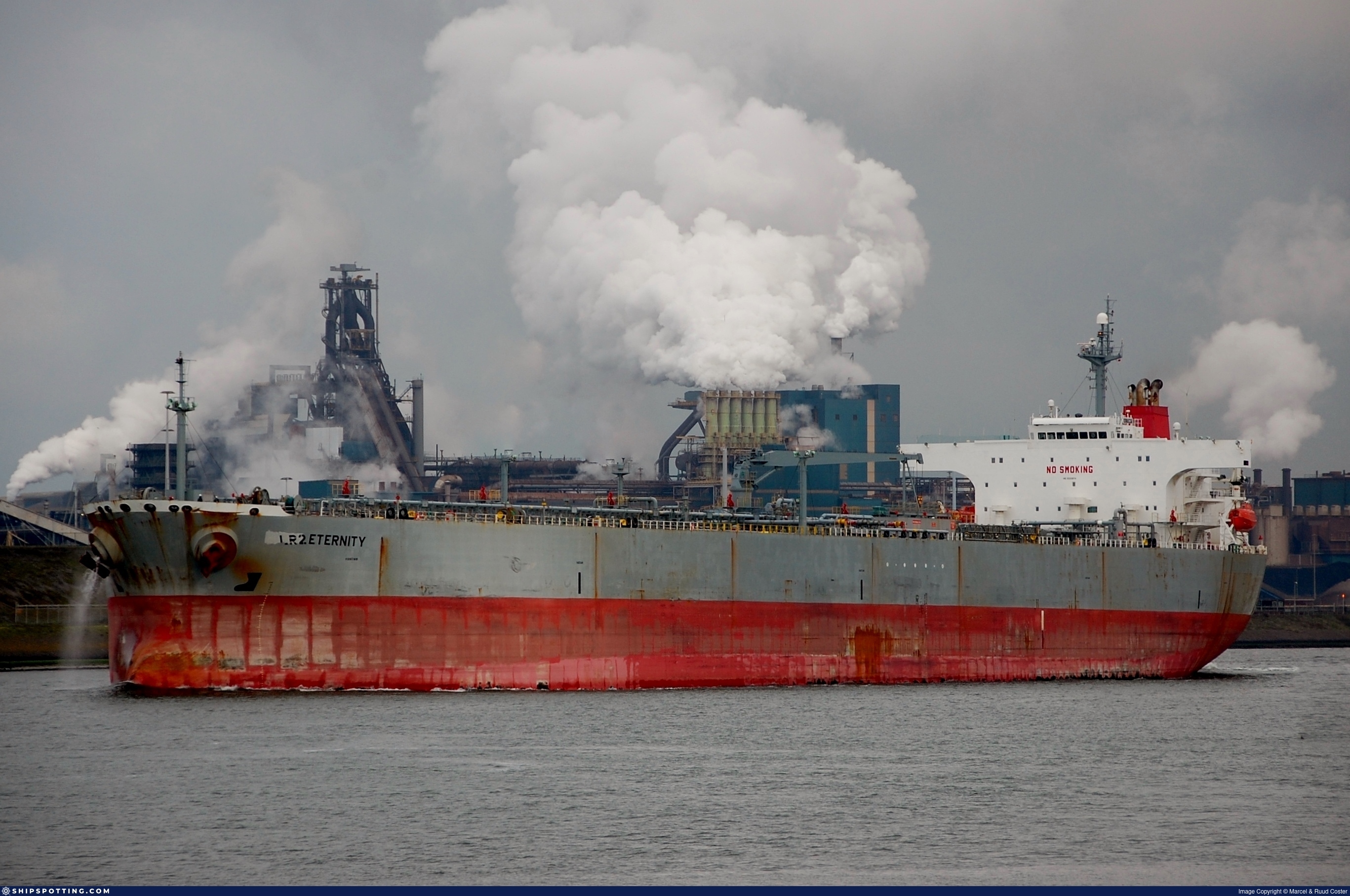
IMO 9323974
Vessel information
Sanctioned by
Company & Ownership
Management & Operations
Classification & Safety
Port State Control (PSC) Inspections
Survey Renewal & Certificates
| Code | Type | Issuer | Issued | Expires |
|---|---|---|---|---|
| 501 | Cargo Ship Safety Construction | RINA Services S.p.A. (186) | 30/03/2022 | 13/11/2026 |
| 503 | Cargo Ship Safety Radio | RINA | 30/03/2022 | 13/11/2026 |
Programs & Notes
EU Russia Sanctions – Shadow Fleet | SEMA (Canada) — vessel designations | The Russia (Sanctions) (EU Exit) Regulations 2019
DateOfListing: 2025-07-20 || DateDesignated: 2025-05-09 | Shipping sanctions: (see “Other information”) | Shipping sanctions: a specified ship is prohibited from being provided with access to or having its master or pilot cause it to enter a port in the UK, may have its registration on the UK Ship Register terminated, and a master or pilot of a specified ship may be given a port barring direction, a detention direction, and a port entry direction or a movement direction. | IMO 9323974 (MARBLE) is involved in activity whose object or effect is to destabilise Ukraine or undermine or threaten the territorial integrity, sovereignty or independence of Ukraine or to obtain a benefit from or support the Government of Russia. Namely, MARBLE is involved in carrying oil or oil products that originated in Russia from Russia to a third country.
Vessel Changes
AIS Events
50 events detected • 1 zone • Last: May 29, 2026
- Minimum Distance: 43 meters
- Average Distance: 45 meters
- Duration: 44 minutes
- Period: 2026-05-29T22:02:55+00:00 to 2026-05-29T22:46:57+00:00
- Vessel A Avg Speed: 0.0 knots
- Vessel B Avg Speed: 0.0 knots
- Zone: Eastern Mediterranean Sanctioned Vessel Zone
Confidence Analysis
Moderate-confidence STS candidate. Two tankers (SINAR G and MARBLE) maintained close proximity (min 43m, avg 45m) for 44 minutes. Both vessels were slow-moving (avg speeds 0.0 and 0.0 knots). The stable separation distance suggests deliberate parallel positioning typical of cargo transfer. Event occurred in Eastern Mediterranean Sanctioned Vessel Zone, a known STS activity area.
View scoring breakdown
| Factor | Score | Detail |
|---|---|---|
| Distance Tightness | 25/25 | Min distance 43m, avg 45m |
| Duration | 5/25 | Duration 44 minutes |
| Speed Stability | 20/20 | both nearly stationary; very stable speeds |
| Distance Consistency | 15/15 | Distance variance ±2m |
| Isolation | 5/10 | Isolation data not available |
| Context | 5/5 | In monitored zone: Eastern Mediterranean Sanctioned Vessel Zone |
🛰️ Satellite Corroboration
No satellite imagery for this time/location
No Sentinel-1 scenes covering AOI and time window
Show Raw Evidence JSON
{
"vessel_a": {
"mmsi": 613271812,
"imo": 9323364,
"name": "SINAR G",
"flag": "Cameroon"
},
"vessel_b": {
"mmsi": 613277612,
"imo": 9323974,
"name": "MARBLE",
"flag": "CAMEROON"
},
"min_distance_m": 42.89999999999999857891452847979962825775146484375,
"avg_distance_m": 45.2000000000000028421709430404007434844970703125,
"distance_consistency_m": 2,
"duration_minutes": 44,
"overlap_duration_s": 2642,
"speed_a_avg": 0,
"speed_a_std": 0,
"speed_b_avg": 0,
"speed_b_std": 0,
"speed_summary": {
"vessel_a": {
"avg_sog": 0,
"max_sog": 0
},
"vessel_b": {
"avg_sog": 0,
"max_sog": 0
}
},
"time_window": {
"start": "2026-05-29T22:02:55+00:00",
"end": "2026-05-29T22:46:57+00:00"
},
"points_count": {
"vessel_a": 8,
"vessel_b": 8
},
"zone_id": "discovered_018",
"zone_name": "Eastern Mediterranean Sanctioned Vessel Zone",
"score": {
"value": 75,
"components": {
"distance_tightness": {
"score": 25,
"max": 25,
"detail": "Min distance 43m, avg 45m"
},
"duration": {
"score": 5,
"max": 25,
"detail": "Duration 44 minutes"
},
"speed_stability": {
"score": 20,
"max": 20,
"detail": "both nearly stationary; very stable speeds"
},
"distance_consistency": {
"score": 15,
"max": 15,
"detail": "Distance variance \u00b12m"
},
"isolation": {
"score": 5,
"max": 10,
"detail": "Isolation data not available"
},
"context": {
"score": 5,
"max": 5,
"detail": "In monitored zone: Eastern Mediterranean Sanctioned Vessel Zone"
}
},
"summary": "Moderate-confidence STS candidate. Two tankers (SINAR G and MARBLE) maintained close proximity (min 43m, avg 45m) for 44 minutes. Both vessels were slow-moving (avg speeds 0.0 and 0.0 knots). The stable separation distance suggests deliberate parallel positioning typical of cargo transfer. Event occurred in Eastern Mediterranean Sanctioned Vessel Zone, a known STS activity area."
},
"sar": {
"status": "not_found",
"centroid": {
"lat": 31.539858599999998745033735758624970912933349609375,
"lon": 32.33103870000000057416400522924959659576416015625
},
"time_window": {
"start_ts": "2026-05-29T22:02:55+00:00",
"end_ts": "2026-05-29T22:46:57+00:00"
},
"searched_at": "2026-05-30T05:00:04.686241+00:00",
"notes": "No Sentinel-1 scenes covering AOI and time window"
}
}- Minimum Distance: 43 meters
- Average Distance: 45 meters
- Duration: 50 minutes
- Period: 2026-05-29T21:56:58+00:00 to 2026-05-29T22:46:57+00:00
- Vessel A Avg Speed: 0.0 knots
- Vessel B Avg Speed: 0.0 knots
- Zone: Eastern Mediterranean Sanctioned Vessel Zone
Confidence Analysis
High-confidence STS candidate. Two tankers (SINAR G and MARBLE) maintained close proximity (min 43m, avg 45m) for 50 minutes. Both vessels were slow-moving (avg speeds 0.0 and 0.0 knots). The stable separation distance suggests deliberate parallel positioning typical of cargo transfer. Event occurred in Eastern Mediterranean Sanctioned Vessel Zone, a known STS activity area.
View scoring breakdown
| Factor | Score | Detail |
|---|---|---|
| Distance Tightness | 25/25 | Min distance 43m, avg 45m |
| Duration | 10/25 | Duration 50 minutes |
| Speed Stability | 20/20 | both nearly stationary; very stable speeds |
| Distance Consistency | 15/15 | Distance variance ±2m |
| Isolation | 5/10 | Isolation data not available |
| Context | 5/5 | In monitored zone: Eastern Mediterranean Sanctioned Vessel Zone |
Show Raw Evidence JSON
{
"vessel_a": {
"mmsi": 613271812,
"imo": 9323364,
"name": "SINAR G",
"flag": "Cameroon"
},
"vessel_b": {
"mmsi": 613277612,
"imo": 9323974,
"name": "MARBLE",
"flag": "CAMEROON"
},
"min_distance_m": 42.89999999999999857891452847979962825775146484375,
"avg_distance_m": 45.10000000000000142108547152020037174224853515625,
"distance_consistency_m": 1.899999999999999911182158029987476766109466552734375,
"duration_minutes": 50,
"overlap_duration_s": 2999,
"speed_a_avg": 0,
"speed_a_std": 0,
"speed_b_avg": 0,
"speed_b_std": 0,
"speed_summary": {
"vessel_a": {
"avg_sog": 0,
"max_sog": 0
},
"vessel_b": {
"avg_sog": 0,
"max_sog": 0
}
},
"time_window": {
"start": "2026-05-29T21:56:58+00:00",
"end": "2026-05-29T22:46:57+00:00"
},
"points_count": {
"vessel_a": 9,
"vessel_b": 9
},
"zone_id": "discovered_018",
"zone_name": "Eastern Mediterranean Sanctioned Vessel Zone",
"score": {
"value": 80,
"components": {
"distance_tightness": {
"score": 25,
"max": 25,
"detail": "Min distance 43m, avg 45m"
},
"duration": {
"score": 10,
"max": 25,
"detail": "Duration 50 minutes"
},
"speed_stability": {
"score": 20,
"max": 20,
"detail": "both nearly stationary; very stable speeds"
},
"distance_consistency": {
"score": 15,
"max": 15,
"detail": "Distance variance \u00b12m"
},
"isolation": {
"score": 5,
"max": 10,
"detail": "Isolation data not available"
},
"context": {
"score": 5,
"max": 5,
"detail": "In monitored zone: Eastern Mediterranean Sanctioned Vessel Zone"
}
},
"summary": "High-confidence STS candidate. Two tankers (SINAR G and MARBLE) maintained close proximity (min 43m, avg 45m) for 50 minutes. Both vessels were slow-moving (avg speeds 0.0 and 0.0 knots). The stable separation distance suggests deliberate parallel positioning typical of cargo transfer. Event occurred in Eastern Mediterranean Sanctioned Vessel Zone, a known STS activity area."
}
}- Zone: Eastern Mediterranean Sanctioned Vessel Zone
- Duration: 1h 5m
- Data Points: 21 AIS positions
- Period: 2026-05-29T21:47:19+00:00 to 2026-05-29T22:52:40+00:00
Show Raw Evidence JSON
{
"zone_id": "discovered_018",
"zone_name": "Eastern Mediterranean Sanctioned Vessel Zone",
"dwell_minutes": 65.2999999999999971578290569595992565155029296875,
"points_in_zone": 21,
"first_point": {
"ts": "2026-05-29T21:47:19+00:00",
"lat": 31.5396266999999994595782482065260410308837890625,
"lon": 32.3310282999999998310158844105899333953857421875
},
"last_point": {
"ts": "2026-05-29T22:52:40+00:00",
"lat": 31.539591699999999008241502451710402965545654296875,
"lon": 32.330991699999998445491655729711055755615234375
}
}- Minimum Distance: 42 meters
- Average Distance: 45 meters
- Duration: 2h 35m
- Period: 2026-05-29T20:16:49+00:00 to 2026-05-29T22:52:40+00:00
- Vessel A Avg Speed: 0.0 knots
- Vessel B Avg Speed: 0.0 knots
- Zone: Eastern Mediterranean Sanctioned Vessel Zone
Confidence Analysis
High-confidence STS candidate. Two tankers (MARBLE and SINAR G) maintained close proximity (min 42m, avg 45m) for 156 minutes. Both vessels were slow-moving (avg speeds 0.0 and 0.0 knots). The stable separation distance suggests deliberate parallel positioning typical of cargo transfer. Event occurred in Eastern Mediterranean Sanctioned Vessel Zone, a known STS activity area.
View scoring breakdown
| Factor | Score | Detail |
|---|---|---|
| Distance Tightness | 25/25 | Min distance 42m, avg 45m |
| Duration | 25/25 | Duration 156 minutes |
| Speed Stability | 20/20 | both nearly stationary; very stable speeds |
| Distance Consistency | 15/15 | Distance variance ±2m |
| Isolation | 5/10 | Isolation data not available |
| Context | 5/5 | In monitored zone: Eastern Mediterranean Sanctioned Vessel Zone |
🛰️ Satellite Corroboration
No satellite imagery for this time/location
No Sentinel-1 scenes covering AOI and time window
Show Raw Evidence JSON
{
"vessel_a": {
"mmsi": 613277612,
"imo": 9323974,
"name": "MARBLE",
"flag": "CAMEROON"
},
"vessel_b": {
"mmsi": 613271812,
"imo": 9323364,
"name": "SINAR G",
"flag": "Cameroon"
},
"min_distance_m": 42,
"avg_distance_m": 45.2999999999999971578290569595992565155029296875,
"distance_consistency_m": 1.8000000000000000444089209850062616169452667236328125,
"duration_minutes": 155.80000000000001136868377216160297393798828125,
"overlap_duration_s": 9351,
"speed_a_avg": 0,
"speed_a_std": 0,
"speed_b_avg": 0,
"speed_b_std": 0,
"speed_summary": {
"vessel_a": {
"avg_sog": 0,
"max_sog": 0
},
"vessel_b": {
"avg_sog": 0,
"max_sog": 0
}
},
"time_window": {
"start": "2026-05-29T20:16:49+00:00",
"end": "2026-05-29T22:52:40+00:00"
},
"points_count": {
"vessel_a": 26,
"vessel_b": 26
},
"zone_id": "discovered_018",
"zone_name": "Eastern Mediterranean Sanctioned Vessel Zone",
"score": {
"value": 95,
"components": {
"distance_tightness": {
"score": 25,
"max": 25,
"detail": "Min distance 42m, avg 45m"
},
"duration": {
"score": 25,
"max": 25,
"detail": "Duration 156 minutes"
},
"speed_stability": {
"score": 20,
"max": 20,
"detail": "both nearly stationary; very stable speeds"
},
"distance_consistency": {
"score": 15,
"max": 15,
"detail": "Distance variance \u00b12m"
},
"isolation": {
"score": 5,
"max": 10,
"detail": "Isolation data not available"
},
"context": {
"score": 5,
"max": 5,
"detail": "In monitored zone: Eastern Mediterranean Sanctioned Vessel Zone"
}
},
"summary": "High-confidence STS candidate. Two tankers (MARBLE and SINAR G) maintained close proximity (min 42m, avg 45m) for 156 minutes. Both vessels were slow-moving (avg speeds 0.0 and 0.0 knots). The stable separation distance suggests deliberate parallel positioning typical of cargo transfer. Event occurred in Eastern Mediterranean Sanctioned Vessel Zone, a known STS activity area."
},
"sar": {
"status": "not_found",
"centroid": {
"lat": 31.5398201000000000249201548285782337188720703125,
"lon": 32.331014199999998481871443800628185272216796875
},
"time_window": {
"start_ts": "2026-05-29T20:16:49+00:00",
"end_ts": "2026-05-29T22:52:40+00:00"
},
"searched_at": "2026-05-29T23:15:08.628340+00:00",
"notes": "No Sentinel-1 scenes covering AOI and time window"
}
}- Duration: 2h 51m
- Radius: 31 meters
- Data Points: 27 AIS positions
- Centroid: 31.5396, 32.3310
- Zone: Eastern Mediterranean Sanctioned Vessel Zone
Show Raw Evidence JSON
{
"radius_m": 31,
"duration_minutes": 171.099999999999994315658113919198513031005859375,
"points": 27,
"centroid": {
"lat": 31.539607640740744187723976210691034793853759765625,
"lon": 32.330996725925928103606565855443477630615234375
},
"bbox": {
"min_lat": 31.539378299999999200053935055620968341827392578125,
"min_lon": 32.3308099999999996043698047287762165069580078125,
"max_lat": 31.539708300000000917862053029239177703857421875,
"max_lon": 32.331068299999998316707205958664417266845703125
},
"zone_id": "discovered_018"
}- Zone: Eastern Mediterranean Sanctioned Vessel Zone
- Duration: 2h 51m
- Data Points: 27 AIS positions
- Period: 2026-05-29T20:01:33+00:00 to 2026-05-29T22:52:40+00:00
Show Raw Evidence JSON
{
"zone_id": "discovered_018",
"zone_name": "Eastern Mediterranean Sanctioned Vessel Zone",
"dwell_minutes": 171.099999999999994315658113919198513031005859375,
"points_in_zone": 27,
"first_point": {
"ts": "2026-05-29T20:01:33+00:00",
"lat": 31.539378299999999200053935055620968341827392578125,
"lon": 32.3308099999999996043698047287762165069580078125
},
"last_point": {
"ts": "2026-05-29T22:52:40+00:00",
"lat": 31.539591699999999008241502451710402965545654296875,
"lon": 32.330991699999998445491655729711055755615234375
}
}- Minimum Distance: 42 meters
- Average Distance: 44 meters
- Duration: 1h 53m
- Period: 2026-05-29T19:03:09+00:00 to 2026-05-29T20:57:01+00:00
- Vessel A Avg Speed: 0.0 knots
- Vessel B Avg Speed: 0.0 knots
- Zone: Eastern Mediterranean Sanctioned Vessel Zone
Confidence Analysis
High-confidence STS candidate. Two tankers (SINAR G and MARBLE) maintained close proximity (min 42m, avg 44m) for 114 minutes. Both vessels were slow-moving (avg speeds 0.0 and 0.0 knots). The stable separation distance suggests deliberate parallel positioning typical of cargo transfer. Event occurred in Eastern Mediterranean Sanctioned Vessel Zone, a known STS activity area.
View scoring breakdown
| Factor | Score | Detail |
|---|---|---|
| Distance Tightness | 25/25 | Min distance 42m, avg 44m |
| Duration | 20/25 | Duration 114 minutes |
| Speed Stability | 20/20 | both nearly stationary; very stable speeds |
| Distance Consistency | 15/15 | Distance variance ±2m |
| Isolation | 5/10 | Isolation data not available |
| Context | 5/5 | In monitored zone: Eastern Mediterranean Sanctioned Vessel Zone |
🛰️ Satellite Corroboration
No satellite imagery for this time/location
No Sentinel-1 scenes covering AOI and time window
Show Raw Evidence JSON
{
"vessel_a": {
"mmsi": 613271812,
"imo": 9323364,
"name": "SINAR G",
"flag": "Cameroon"
},
"vessel_b": {
"mmsi": 613277612,
"imo": 9323974,
"name": "MARBLE",
"flag": "CAMEROON"
},
"min_distance_m": 42,
"avg_distance_m": 44,
"distance_consistency_m": 1.5,
"duration_minutes": 113.900000000000005684341886080801486968994140625,
"overlap_duration_s": 6832,
"speed_a_avg": 0.0200000000000000004163336342344337026588618755340576171875,
"speed_a_std": 0.040000000000000000832667268468867405317723751068115234375,
"speed_b_avg": 0,
"speed_b_std": 0,
"speed_summary": {
"vessel_a": {
"avg_sog": 0.0200000000000000004163336342344337026588618755340576171875,
"max_sog": 0.1000000000000000055511151231257827021181583404541015625
},
"vessel_b": {
"avg_sog": 0,
"max_sog": 0
}
},
"time_window": {
"start": "2026-05-29T19:03:09+00:00",
"end": "2026-05-29T20:57:01+00:00"
},
"points_count": {
"vessel_a": 6,
"vessel_b": 6
},
"zone_id": "discovered_018",
"zone_name": "Eastern Mediterranean Sanctioned Vessel Zone",
"score": {
"value": 90,
"components": {
"distance_tightness": {
"score": 25,
"max": 25,
"detail": "Min distance 42m, avg 44m"
},
"duration": {
"score": 20,
"max": 25,
"detail": "Duration 114 minutes"
},
"speed_stability": {
"score": 20,
"max": 20,
"detail": "both nearly stationary; very stable speeds"
},
"distance_consistency": {
"score": 15,
"max": 15,
"detail": "Distance variance \u00b12m"
},
"isolation": {
"score": 5,
"max": 10,
"detail": "Isolation data not available"
},
"context": {
"score": 5,
"max": 5,
"detail": "In monitored zone: Eastern Mediterranean Sanctioned Vessel Zone"
}
},
"summary": "High-confidence STS candidate. Two tankers (SINAR G and MARBLE) maintained close proximity (min 42m, avg 44m) for 114 minutes. Both vessels were slow-moving (avg speeds 0.0 and 0.0 knots). The stable separation distance suggests deliberate parallel positioning typical of cargo transfer. Event occurred in Eastern Mediterranean Sanctioned Vessel Zone, a known STS activity area."
},
"sar": {
"status": "not_found",
"centroid": {
"lat": 31.539649900000000570798874832689762115478515625,
"lon": 32.3308976000000001249645720236003398895263671875
},
"time_window": {
"start_ts": "2026-05-29T19:03:09+00:00",
"end_ts": "2026-05-29T20:57:01+00:00"
},
"searched_at": "2026-05-30T02:00:02.338540+00:00",
"notes": "No Sentinel-1 scenes covering AOI and time window"
}
}- Duration: 3h 50m
- Radius: 26 meters
- Data Points: 38 AIS positions
- Centroid: 31.5395, 32.3309
- Zone: Eastern Mediterranean Sanctioned Vessel Zone
Show Raw Evidence JSON
{
"radius_m": 25.60000000000000142108547152020037174224853515625,
"duration_minutes": 230.69999999999998863131622783839702606201171875,
"points": 38,
"centroid": {
"lat": 31.539547049999999472902345587499439716339111328125,
"lon": 32.33094679736841925432599964551627635955810546875
},
"bbox": {
"min_lat": 31.539363300000001544276528875343501567840576171875,
"min_lon": 32.33078330000000022437234292738139629364013671875,
"max_lat": 31.539708300000000917862053029239177703857421875,
"max_lon": 32.331068299999998316707205958664417266845703125
},
"zone_id": "discovered_018"
}- Zone: Eastern Mediterranean Sanctioned Vessel Zone
- Duration: 3h 50m
- Data Points: 38 AIS positions
- Period: 2026-05-29T19:01:58+00:00 to 2026-05-29T22:52:40+00:00
Show Raw Evidence JSON
{
"zone_id": "discovered_018",
"zone_name": "Eastern Mediterranean Sanctioned Vessel Zone",
"dwell_minutes": 230.69999999999998863131622783839702606201171875,
"points_in_zone": 38,
"first_point": {
"ts": "2026-05-29T19:01:58+00:00",
"lat": 31.539363300000001544276528875343501567840576171875,
"lon": 32.33078330000000022437234292738139629364013671875
},
"last_point": {
"ts": "2026-05-29T22:52:40+00:00",
"lat": 31.539591699999999008241502451710402965545654296875,
"lon": 32.330991699999998445491655729711055755615234375
}
}- Minimum Distance: 40 meters
- Average Distance: 43 meters
- Duration: 2h 53m
- Period: 2026-05-29T18:03:10+00:00 to 2026-05-29T20:57:01+00:00
- Vessel A Avg Speed: 0.0 knots
- Vessel B Avg Speed: 0.0 knots
- Zone: Eastern Mediterranean Sanctioned Vessel Zone
Confidence Analysis
High-confidence STS candidate. Two tankers (SINAR G and MARBLE) maintained close proximity (min 40m, avg 43m) for 174 minutes. Both vessels were slow-moving (avg speeds 0.0 and 0.0 knots). The stable separation distance suggests deliberate parallel positioning typical of cargo transfer. Event occurred in Eastern Mediterranean Sanctioned Vessel Zone, a known STS activity area.
View scoring breakdown
| Factor | Score | Detail |
|---|---|---|
| Distance Tightness | 25/25 | Min distance 40m, avg 43m |
| Duration | 25/25 | Duration 174 minutes |
| Speed Stability | 20/20 | both nearly stationary; very stable speeds |
| Distance Consistency | 15/15 | Distance variance ±2m |
| Isolation | 5/10 | Isolation data not available |
| Context | 5/5 | In monitored zone: Eastern Mediterranean Sanctioned Vessel Zone |
🛰️ Satellite Corroboration
No satellite imagery for this time/location
No Sentinel-1 scenes covering AOI and time window
Show Raw Evidence JSON
{
"vessel_a": {
"mmsi": 613271812,
"imo": 9323364,
"name": "SINAR G",
"flag": "Cameroon"
},
"vessel_b": {
"mmsi": 613277612,
"imo": 9323974,
"name": "MARBLE",
"flag": "CAMEROON"
},
"min_distance_m": 40.2000000000000028421709430404007434844970703125,
"avg_distance_m": 43.39999999999999857891452847979962825775146484375,
"distance_consistency_m": 1.899999999999999911182158029987476766109466552734375,
"duration_minutes": 173.80000000000001136868377216160297393798828125,
"overlap_duration_s": 10431,
"speed_a_avg": 0.01000000000000000020816681711721685132943093776702880859375,
"speed_a_std": 0.0299999999999999988897769753748434595763683319091796875,
"speed_b_avg": 0,
"speed_b_std": 0,
"speed_summary": {
"vessel_a": {
"avg_sog": 0.01000000000000000020816681711721685132943093776702880859375,
"max_sog": 0.1000000000000000055511151231257827021181583404541015625
},
"vessel_b": {
"avg_sog": 0,
"max_sog": 0
}
},
"time_window": {
"start": "2026-05-29T18:03:10+00:00",
"end": "2026-05-29T20:57:01+00:00"
},
"points_count": {
"vessel_a": 9,
"vessel_b": 9
},
"zone_id": "discovered_018",
"zone_name": "Eastern Mediterranean Sanctioned Vessel Zone",
"score": {
"value": 95,
"components": {
"distance_tightness": {
"score": 25,
"max": 25,
"detail": "Min distance 40m, avg 43m"
},
"duration": {
"score": 25,
"max": 25,
"detail": "Duration 174 minutes"
},
"speed_stability": {
"score": 20,
"max": 20,
"detail": "both nearly stationary; very stable speeds"
},
"distance_consistency": {
"score": 15,
"max": 15,
"detail": "Distance variance \u00b12m"
},
"isolation": {
"score": 5,
"max": 10,
"detail": "Isolation data not available"
},
"context": {
"score": 5,
"max": 5,
"detail": "In monitored zone: Eastern Mediterranean Sanctioned Vessel Zone"
}
},
"summary": "High-confidence STS candidate. Two tankers (SINAR G and MARBLE) maintained close proximity (min 40m, avg 43m) for 174 minutes. Both vessels were slow-moving (avg speeds 0.0 and 0.0 knots). The stable separation distance suggests deliberate parallel positioning typical of cargo transfer. Event occurred in Eastern Mediterranean Sanctioned Vessel Zone, a known STS activity area."
},
"sar": {
"status": "not_found",
"centroid": {
"lat": 31.539594699999998539396983687765896320343017578125,
"lon": 32.33086080000000350764821632765233516693115234375
},
"time_window": {
"start_ts": "2026-05-29T18:03:10+00:00",
"end_ts": "2026-05-29T20:57:01+00:00"
},
"searched_at": "2026-05-30T01:00:07.795396+00:00",
"notes": "No Sentinel-1 scenes covering AOI and time window"
}
}- Duration: 4h 52m
- Radius: 35 meters
- Data Points: 54 AIS positions
- Centroid: 31.5395, 32.3309
- Zone: Eastern Mediterranean Sanctioned Vessel Zone
Show Raw Evidence JSON
{
"radius_m": 35,
"duration_minutes": 292.3999999999999772626324556767940521240234375,
"points": 54,
"centroid": {
"lat": 31.539485083333335779798289877362549304962158203125,
"lon": 32.3308943833333302109167561866343021392822265625
},
"bbox": {
"min_lat": 31.539235000000001463149601477198302745819091796875,
"min_lon": 32.33066999999999779902282170951366424560546875,
"max_lat": 31.539708300000000917862053029239177703857421875,
"max_lon": 32.331068299999998316707205958664417266845703125
},
"zone_id": "discovered_018"
}- Zone: Eastern Mediterranean Sanctioned Vessel Zone
- Duration: 4h 52m
- Data Points: 54 AIS positions
- Period: 2026-05-29T18:00:16+00:00 to 2026-05-29T22:52:40+00:00
Show Raw Evidence JSON
{
"zone_id": "discovered_018",
"zone_name": "Eastern Mediterranean Sanctioned Vessel Zone",
"dwell_minutes": 292.3999999999999772626324556767940521240234375,
"points_in_zone": 54,
"first_point": {
"ts": "2026-05-29T18:00:16+00:00",
"lat": 31.53924500000000108457243186421692371368408203125,
"lon": 32.33067170000000345453372574411332607269287109375
},
"last_point": {
"ts": "2026-05-29T22:52:40+00:00",
"lat": 31.539591699999999008241502451710402965545654296875,
"lon": 32.330991699999998445491655729711055755615234375
}
}- Duration: 5h 52m
- Radius: 38 meters
- Data Points: 71 AIS positions
- Centroid: 31.5394, 32.3308
- Zone: Eastern Mediterranean Sanctioned Vessel Zone
Show Raw Evidence JSON
{
"radius_m": 38.10000000000000142108547152020037174224853515625,
"duration_minutes": 352.19999999999998863131622783839702606201171875,
"points": 71,
"centroid": {
"lat": 31.53942585915493879156201728619635105133056640625,
"lon": 32.33084026197183646900157327763736248016357421875
},
"bbox": {
"min_lat": 31.53918829999999928759280010126531124114990234375,
"min_lon": 32.3305782999999991034201229922473430633544921875,
"max_lat": 31.539708300000000917862053029239177703857421875,
"max_lon": 32.331068299999998316707205958664417266845703125
},
"zone_id": "discovered_018"
}- Zone: Eastern Mediterranean Sanctioned Vessel Zone
- Duration: 5h 52m
- Data Points: 71 AIS positions
- Period: 2026-05-29T17:00:29+00:00 to 2026-05-29T22:52:40+00:00
Show Raw Evidence JSON
{
"zone_id": "discovered_018",
"zone_name": "Eastern Mediterranean Sanctioned Vessel Zone",
"dwell_minutes": 352.19999999999998863131622783839702606201171875,
"points_in_zone": 71,
"first_point": {
"ts": "2026-05-29T17:00:29+00:00",
"lat": 31.5392149999999986675902619026601314544677734375,
"lon": 32.33065500000000014324541552923619747161865234375
},
"last_point": {
"ts": "2026-05-29T22:52:40+00:00",
"lat": 31.539591699999999008241502451710402965545654296875,
"lon": 32.330991699999998445491655729711055755615234375
}
}- Minimum Distance: 40 meters
- Average Distance: 43 meters
- Duration: 3h 47m
- Period: 2026-05-29T17:09:10+00:00 to 2026-05-29T20:57:01+00:00
- Vessel A Avg Speed: 0.0 knots
- Vessel B Avg Speed: 0.0 knots
- Zone: Eastern Mediterranean Sanctioned Vessel Zone
Confidence Analysis
High-confidence STS candidate. Two tankers (SINAR G and MARBLE) maintained close proximity (min 40m, avg 43m) for 228 minutes. Both vessels were slow-moving (avg speeds 0.0 and 0.0 knots). The stable separation distance suggests deliberate parallel positioning typical of cargo transfer. Event occurred in Eastern Mediterranean Sanctioned Vessel Zone, a known STS activity area.
View scoring breakdown
| Factor | Score | Detail |
|---|---|---|
| Distance Tightness | 25/25 | Min distance 40m, avg 43m |
| Duration | 25/25 | Duration 228 minutes |
| Speed Stability | 20/20 | both nearly stationary; very stable speeds |
| Distance Consistency | 15/15 | Distance variance ±2m |
| Isolation | 5/10 | Isolation data not available |
| Context | 5/5 | In monitored zone: Eastern Mediterranean Sanctioned Vessel Zone |
Show Raw Evidence JSON
{
"vessel_a": {
"mmsi": 613271812,
"imo": 9323364,
"name": "SINAR G",
"flag": "Cameroon"
},
"vessel_b": {
"mmsi": 613277612,
"imo": 9323974,
"name": "MARBLE",
"flag": "CAMEROON"
},
"min_distance_m": 40.2000000000000028421709430404007434844970703125,
"avg_distance_m": 43.2999999999999971578290569595992565155029296875,
"distance_consistency_m": 1.6999999999999999555910790149937383830547332763671875,
"duration_minutes": 227.80000000000001136868377216160297393798828125,
"overlap_duration_s": 13671,
"speed_a_avg": 0.01000000000000000020816681711721685132943093776702880859375,
"speed_a_std": 0.040000000000000000832667268468867405317723751068115234375,
"speed_b_avg": 0,
"speed_b_std": 0,
"speed_summary": {
"vessel_a": {
"avg_sog": 0.01000000000000000020816681711721685132943093776702880859375,
"max_sog": 0.1000000000000000055511151231257827021181583404541015625
},
"vessel_b": {
"avg_sog": 0,
"max_sog": 0
}
},
"time_window": {
"start": "2026-05-29T17:09:10+00:00",
"end": "2026-05-29T20:57:01+00:00"
},
"points_count": {
"vessel_a": 14,
"vessel_b": 14
},
"zone_id": "discovered_018",
"zone_name": "Eastern Mediterranean Sanctioned Vessel Zone",
"score": {
"value": 95,
"components": {
"distance_tightness": {
"score": 25,
"max": 25,
"detail": "Min distance 40m, avg 43m"
},
"duration": {
"score": 25,
"max": 25,
"detail": "Duration 228 minutes"
},
"speed_stability": {
"score": 20,
"max": 20,
"detail": "both nearly stationary; very stable speeds"
},
"distance_consistency": {
"score": 15,
"max": 15,
"detail": "Distance variance \u00b12m"
},
"isolation": {
"score": 5,
"max": 10,
"detail": "Isolation data not available"
},
"context": {
"score": 5,
"max": 5,
"detail": "In monitored zone: Eastern Mediterranean Sanctioned Vessel Zone"
}
},
"summary": "High-confidence STS candidate. Two tankers (SINAR G and MARBLE) maintained close proximity (min 40m, avg 43m) for 228 minutes. Both vessels were slow-moving (avg speeds 0.0 and 0.0 knots). The stable separation distance suggests deliberate parallel positioning typical of cargo transfer. Event occurred in Eastern Mediterranean Sanctioned Vessel Zone, a known STS activity area."
}
}- Minimum Distance: 40 meters
- Average Distance: 44 meters
- Duration: 4 hours
- Period: 2026-05-29T16:56:54+00:00 to 2026-05-29T20:57:01+00:00
- Vessel A Avg Speed: 0.0 knots
- Vessel B Avg Speed: 0.0 knots
- Zone: Eastern Mediterranean Sanctioned Vessel Zone
Confidence Analysis
High-confidence STS candidate. Two tankers (SINAR G and MARBLE) maintained close proximity (min 40m, avg 44m) for 240 minutes. Both vessels were slow-moving (avg speeds 0.0 and 0.0 knots). The stable separation distance suggests deliberate parallel positioning typical of cargo transfer. Event occurred in Eastern Mediterranean Sanctioned Vessel Zone, a known STS activity area.
View scoring breakdown
| Factor | Score | Detail |
|---|---|---|
| Distance Tightness | 25/25 | Min distance 40m, avg 44m |
| Duration | 25/25 | Duration 240 minutes |
| Speed Stability | 20/20 | both nearly stationary; very stable speeds |
| Distance Consistency | 15/15 | Distance variance ±2m |
| Isolation | 5/10 | Isolation data not available |
| Context | 5/5 | In monitored zone: Eastern Mediterranean Sanctioned Vessel Zone |
Show Raw Evidence JSON
{
"vessel_a": {
"mmsi": 613271812,
"imo": 9323364,
"name": "SINAR G",
"flag": "Cameroon"
},
"vessel_b": {
"mmsi": 613277612,
"imo": 9323974,
"name": "MARBLE",
"flag": "CAMEROON"
},
"min_distance_m": 40.2000000000000028421709430404007434844970703125,
"avg_distance_m": 43.5,
"distance_consistency_m": 1.6999999999999999555910790149937383830547332763671875,
"duration_minutes": 240.099999999999994315658113919198513031005859375,
"overlap_duration_s": 14407,
"speed_a_avg": 0.01000000000000000020816681711721685132943093776702880859375,
"speed_a_std": 0.0299999999999999988897769753748434595763683319091796875,
"speed_b_avg": 0,
"speed_b_std": 0,
"speed_summary": {
"vessel_a": {
"avg_sog": 0.01000000000000000020816681711721685132943093776702880859375,
"max_sog": 0.1000000000000000055511151231257827021181583404541015625
},
"vessel_b": {
"avg_sog": 0,
"max_sog": 0
}
},
"time_window": {
"start": "2026-05-29T16:56:54+00:00",
"end": "2026-05-29T20:57:01+00:00"
},
"points_count": {
"vessel_a": 16,
"vessel_b": 16
},
"zone_id": "discovered_018",
"zone_name": "Eastern Mediterranean Sanctioned Vessel Zone",
"score": {
"value": 95,
"components": {
"distance_tightness": {
"score": 25,
"max": 25,
"detail": "Min distance 40m, avg 44m"
},
"duration": {
"score": 25,
"max": 25,
"detail": "Duration 240 minutes"
},
"speed_stability": {
"score": 20,
"max": 20,
"detail": "both nearly stationary; very stable speeds"
},
"distance_consistency": {
"score": 15,
"max": 15,
"detail": "Distance variance \u00b12m"
},
"isolation": {
"score": 5,
"max": 10,
"detail": "Isolation data not available"
},
"context": {
"score": 5,
"max": 5,
"detail": "In monitored zone: Eastern Mediterranean Sanctioned Vessel Zone"
}
},
"summary": "High-confidence STS candidate. Two tankers (SINAR G and MARBLE) maintained close proximity (min 40m, avg 44m) for 240 minutes. Both vessels were slow-moving (avg speeds 0.0 and 0.0 knots). The stable separation distance suggests deliberate parallel positioning typical of cargo transfer. Event occurred in Eastern Mediterranean Sanctioned Vessel Zone, a known STS activity area."
}
}- Duration: 6h 15m
- Radius: 40 meters
- Data Points: 77 AIS positions
- Centroid: 31.5394, 32.3308
- Zone: Eastern Mediterranean Sanctioned Vessel Zone
Show Raw Evidence JSON
{
"radius_m": 39.7000000000000028421709430404007434844970703125,
"duration_minutes": 375.30000000000001136868377216160297393798828125,
"points": 77,
"centroid": {
"lat": 31.53941367142858354100098949857056140899658203125,
"lon": 32.330830111688328543095849454402923583984375
},
"bbox": {
"min_lat": 31.53918829999999928759280010126531124114990234375,
"min_lon": 32.3305782999999991034201229922473430633544921875,
"max_lat": 31.539708300000000917862053029239177703857421875,
"max_lon": 32.331068299999998316707205958664417266845703125
},
"zone_id": "discovered_018"
}- Zone: Eastern Mediterranean Sanctioned Vessel Zone
- Duration: 6h 15m
- Data Points: 77 AIS positions
- Period: 2026-05-29T16:37:20+00:00 to 2026-05-29T22:52:40+00:00
Show Raw Evidence JSON
{
"zone_id": "discovered_018",
"zone_name": "Eastern Mediterranean Sanctioned Vessel Zone",
"dwell_minutes": 375.30000000000001136868377216160297393798828125,
"points_in_zone": 77,
"first_point": {
"ts": "2026-05-29T16:37:20+00:00",
"lat": 31.539320000000000021600499167107045650482177734375,
"lon": 32.3307582999999993944584275595843791961669921875
},
"last_point": {
"ts": "2026-05-29T22:52:40+00:00",
"lat": 31.539591699999999008241502451710402965545654296875,
"lon": 32.330991699999998445491655729711055755615234375
}
}- Minimum Distance: 17 meters
- Average Distance: 26 meters
- Duration: 33 minutes
- Period: 2026-05-19T23:05:39+00:00 to 2026-05-19T23:38:39+00:00
- Vessel A Avg Speed: 0.0 knots
- Vessel B Avg Speed: 0.0 knots
- Zone: Eastern Mediterranean Sanctioned Vessel Zone
Confidence Analysis
Moderate-confidence STS candidate. Two tankers (MARBLE and RHEIN) maintained close proximity (min 17m, avg 26m) for 33 minutes. Both vessels were slow-moving (avg speeds 0.0 and 0.0 knots). The stable separation distance suggests deliberate parallel positioning typical of cargo transfer. Event occurred in Eastern Mediterranean Sanctioned Vessel Zone, a known STS activity area.
View scoring breakdown
| Factor | Score | Detail |
|---|---|---|
| Distance Tightness | 25/25 | Min distance 17m, avg 26m |
| Duration | 5/25 | Duration 33 minutes |
| Speed Stability | 20/20 | both nearly stationary; very stable speeds |
| Distance Consistency | 15/15 | Distance variance ±5m |
| Isolation | 5/10 | Isolation data not available |
| Context | 5/5 | In monitored zone: Eastern Mediterranean Sanctioned Vessel Zone |
🛰️ Satellite Corroboration
No satellite imagery for this time/location
No Sentinel-1 scenes covering AOI and time window
Show Raw Evidence JSON
{
"vessel_a": {
"mmsi": 613277612,
"imo": 9323974,
"name": "MARBLE",
"flag": "CAMEROON"
},
"vessel_b": {
"mmsi": 613271814,
"imo": 9306562,
"name": "RHEIN",
"flag": "CAMEROON"
},
"min_distance_m": 16.89999999999999857891452847979962825775146484375,
"avg_distance_m": 26.39999999999999857891452847979962825775146484375,
"distance_consistency_m": 5.20000000000000017763568394002504646778106689453125,
"duration_minutes": 33,
"overlap_duration_s": 1980,
"speed_a_avg": 0,
"speed_a_std": 0,
"speed_b_avg": 0.0299999999999999988897769753748434595763683319091796875,
"speed_b_std": 0.08000000000000000166533453693773481063544750213623046875,
"speed_summary": {
"vessel_a": {
"avg_sog": 0,
"max_sog": 0
},
"vessel_b": {
"avg_sog": 0.0299999999999999988897769753748434595763683319091796875,
"max_sog": 0.200000000000000011102230246251565404236316680908203125
}
},
"time_window": {
"start": "2026-05-19T23:05:39+00:00",
"end": "2026-05-19T23:38:39+00:00"
},
"points_count": {
"vessel_a": 7,
"vessel_b": 7
},
"zone_id": "discovered_018",
"zone_name": "Eastern Mediterranean Sanctioned Vessel Zone",
"score": {
"value": 75,
"components": {
"distance_tightness": {
"score": 25,
"max": 25,
"detail": "Min distance 17m, avg 26m"
},
"duration": {
"score": 5,
"max": 25,
"detail": "Duration 33 minutes"
},
"speed_stability": {
"score": 20,
"max": 20,
"detail": "both nearly stationary; very stable speeds"
},
"distance_consistency": {
"score": 15,
"max": 15,
"detail": "Distance variance \u00b15m"
},
"isolation": {
"score": 5,
"max": 10,
"detail": "Isolation data not available"
},
"context": {
"score": 5,
"max": 5,
"detail": "In monitored zone: Eastern Mediterranean Sanctioned Vessel Zone"
}
},
"summary": "Moderate-confidence STS candidate. Two tankers (MARBLE and RHEIN) maintained close proximity (min 17m, avg 26m) for 33 minutes. Both vessels were slow-moving (avg speeds 0.0 and 0.0 knots). The stable separation distance suggests deliberate parallel positioning typical of cargo transfer. Event occurred in Eastern Mediterranean Sanctioned Vessel Zone, a known STS activity area."
},
"sar": {
"status": "not_found",
"centroid": {
"lat": 31.513342200000000303816705127246677875518798828125,
"lon": 32.40777560000000079298843047581613063812255859375
},
"time_window": {
"start_ts": "2026-05-19T23:02:43+00:00",
"end_ts": "2026-05-19T23:38:39+00:00"
},
"searched_at": "2026-05-20T06:00:05.472526+00:00",
"notes": "No Sentinel-1 scenes covering AOI and time window"
}
}- Zone: Eastern Mediterranean Sanctioned Vessel Zone
- Duration: 1h 21m
- Data Points: 15 AIS positions
- Period: 2026-05-19T22:17:42+00:00 to 2026-05-19T23:38:39+00:00
Show Raw Evidence JSON
{
"zone_id": "discovered_018",
"zone_name": "Eastern Mediterranean Sanctioned Vessel Zone",
"dwell_minutes": 81,
"points_in_zone": 15,
"first_point": {
"ts": "2026-05-19T22:17:42+00:00",
"lat": 31.51297170000000136269591166637837886810302734375,
"lon": 32.4071933000000029778675525449216365814208984375
},
"last_point": {
"ts": "2026-05-19T23:38:39+00:00",
"lat": 31.5134766999999982317604008130729198455810546875,
"lon": 32.4078166999999979225322022102773189544677734375
}
}- Minimum Distance: 17 meters
- Average Distance: 25 meters
- Duration: 50 minutes
- Period: 2026-05-19T22:47:44+00:00 to 2026-05-19T23:38:39+00:00
- Vessel A Avg Speed: 0.0 knots
- Vessel B Avg Speed: 0.0 knots
- Zone: Eastern Mediterranean Sanctioned Vessel Zone
Confidence Analysis
High-confidence STS candidate. Two tankers (MARBLE and RHEIN) maintained close proximity (min 17m, avg 25m) for 51 minutes. Both vessels were slow-moving (avg speeds 0.0 and 0.0 knots). The stable separation distance suggests deliberate parallel positioning typical of cargo transfer. Event occurred in Eastern Mediterranean Sanctioned Vessel Zone, a known STS activity area.
View scoring breakdown
| Factor | Score | Detail |
|---|---|---|
| Distance Tightness | 25/25 | Min distance 17m, avg 25m |
| Duration | 10/25 | Duration 51 minutes |
| Speed Stability | 20/20 | both nearly stationary; very stable speeds |
| Distance Consistency | 15/15 | Distance variance ±5m |
| Isolation | 5/10 | Isolation data not available |
| Context | 5/5 | In monitored zone: Eastern Mediterranean Sanctioned Vessel Zone |
Show Raw Evidence JSON
{
"vessel_a": {
"mmsi": 613277612,
"imo": 9323974,
"name": "MARBLE",
"flag": "CAMEROON"
},
"vessel_b": {
"mmsi": 613271814,
"imo": 9306562,
"name": "RHEIN",
"flag": "CAMEROON"
},
"min_distance_m": 16.89999999999999857891452847979962825775146484375,
"avg_distance_m": 25.39999999999999857891452847979962825775146484375,
"distance_consistency_m": 5.0999999999999996447286321199499070644378662109375,
"duration_minutes": 50.89999999999999857891452847979962825775146484375,
"overlap_duration_s": 3055,
"speed_a_avg": 0,
"speed_a_std": 0,
"speed_b_avg": 0.0200000000000000004163336342344337026588618755340576171875,
"speed_b_std": 0.059999999999999997779553950749686919152736663818359375,
"speed_summary": {
"vessel_a": {
"avg_sog": 0,
"max_sog": 0
},
"vessel_b": {
"avg_sog": 0.0200000000000000004163336342344337026588618755340576171875,
"max_sog": 0.200000000000000011102230246251565404236316680908203125
}
},
"time_window": {
"start": "2026-05-19T22:47:44+00:00",
"end": "2026-05-19T23:38:39+00:00"
},
"points_count": {
"vessel_a": 10,
"vessel_b": 10
},
"zone_id": "discovered_018",
"zone_name": "Eastern Mediterranean Sanctioned Vessel Zone",
"score": {
"value": 80,
"components": {
"distance_tightness": {
"score": 25,
"max": 25,
"detail": "Min distance 17m, avg 25m"
},
"duration": {
"score": 10,
"max": 25,
"detail": "Duration 51 minutes"
},
"speed_stability": {
"score": 20,
"max": 20,
"detail": "both nearly stationary; very stable speeds"
},
"distance_consistency": {
"score": 15,
"max": 15,
"detail": "Distance variance \u00b15m"
},
"isolation": {
"score": 5,
"max": 10,
"detail": "Isolation data not available"
},
"context": {
"score": 5,
"max": 5,
"detail": "In monitored zone: Eastern Mediterranean Sanctioned Vessel Zone"
}
},
"summary": "High-confidence STS candidate. Two tankers (MARBLE and RHEIN) maintained close proximity (min 17m, avg 25m) for 51 minutes. Both vessels were slow-moving (avg speeds 0.0 and 0.0 knots). The stable separation distance suggests deliberate parallel positioning typical of cargo transfer. Event occurred in Eastern Mediterranean Sanctioned Vessel Zone, a known STS activity area."
}
}- Duration: 2h 33m
- Radius: 75 meters
- Data Points: 17 AIS positions
- Centroid: 31.5131, 32.4074
- Zone: Eastern Mediterranean Sanctioned Vessel Zone
Show Raw Evidence JSON
{
"radius_m": 75,
"duration_minutes": 153,
"points": 17,
"centroid": {
"lat": 31.513103435294116394516095169819891452789306640625,
"lon": 32.40743068235294543910640641115605831146240234375
},
"bbox": {
"min_lat": 31.51269500000000078898665378801524639129638671875,
"min_lon": 32.4068017000000025973349693231284618377685546875,
"max_lat": 31.5134766999999982317604008130729198455810546875,
"max_lon": 32.4078166999999979225322022102773189544677734375
},
"zone_id": "discovered_018"
}- Zone: Eastern Mediterranean Sanctioned Vessel Zone
- Duration: 2h 33m
- Data Points: 17 AIS positions
- Period: 2026-05-19T21:05:41+00:00 to 2026-05-19T23:38:39+00:00
Show Raw Evidence JSON
{
"zone_id": "discovered_018",
"zone_name": "Eastern Mediterranean Sanctioned Vessel Zone",
"dwell_minutes": 153,
"points_in_zone": 17,
"first_point": {
"ts": "2026-05-19T21:05:41+00:00",
"lat": 31.51269500000000078898665378801524639129638671875,
"lon": 32.4068017000000025973349693231284618377685546875
},
"last_point": {
"ts": "2026-05-19T23:38:39+00:00",
"lat": 31.5134766999999982317604008130729198455810546875,
"lon": 32.4078166999999979225322022102773189544677734375
}
}- Duration: 3h 20m
- Radius: 69 meters
- Data Points: 19 AIS positions
- Centroid: 31.5131, 32.4074
- Zone: Eastern Mediterranean Sanctioned Vessel Zone
Show Raw Evidence JSON
{
"radius_m": 69.400000000000005684341886080801486968994140625,
"duration_minutes": 200.900000000000005684341886080801486968994140625,
"points": 19,
"centroid": {
"lat": 31.513066931578944007696918561123311519622802734375,
"lon": 32.4073607894736852585992892272770404815673828125
},
"bbox": {
"min_lat": 31.51269500000000078898665378801524639129638671875,
"min_lon": 32.4067117000000024518158170394599437713623046875,
"max_lat": 31.5134766999999982317604008130729198455810546875,
"max_lon": 32.4078166999999979225322022102773189544677734375
},
"zone_id": "discovered_018"
}- Zone: Eastern Mediterranean Sanctioned Vessel Zone
- Duration: 3h 20m
- Data Points: 19 AIS positions
- Period: 2026-05-19T20:17:43+00:00 to 2026-05-19T23:38:39+00:00
Show Raw Evidence JSON
{
"zone_id": "discovered_018",
"zone_name": "Eastern Mediterranean Sanctioned Vessel Zone",
"dwell_minutes": 200.900000000000005684341886080801486968994140625,
"points_in_zone": 19,
"first_point": {
"ts": "2026-05-19T20:17:43+00:00",
"lat": 31.51277999999999934743755147792398929595947265625,
"lon": 32.4067117000000024518158170394599437713623046875
},
"last_point": {
"ts": "2026-05-19T23:38:39+00:00",
"lat": 31.5134766999999982317604008130729198455810546875,
"lon": 32.4078166999999979225322022102773189544677734375
}
}- Duration: 4h 33m
- Radius: 94 meters
- Data Points: 29 AIS positions
- Centroid: 31.5129, 32.4071
- Zone: Eastern Mediterranean Sanctioned Vessel Zone
Show Raw Evidence JSON
{
"radius_m": 93.7000000000000028421709430404007434844970703125,
"duration_minutes": 273,
"points": 29,
"centroid": {
"lat": 31.512944999999991324557413463480770587921142578125,
"lon": 32.4070500034482762430343427695333957672119140625
},
"bbox": {
"min_lat": 31.51263000000000147338141687214374542236328125,
"min_lon": 32.4062966999999986228431225754320621490478515625,
"max_lat": 31.5134766999999982317604008130729198455810546875,
"max_lon": 32.4078166999999979225322022102773189544677734375
},
"zone_id": "discovered_018"
}- Zone: Eastern Mediterranean Sanctioned Vessel Zone
- Duration: 4h 33m
- Data Points: 29 AIS positions
- Period: 2026-05-19T19:05:39+00:00 to 2026-05-19T23:38:39+00:00
Show Raw Evidence JSON
{
"zone_id": "discovered_018",
"zone_name": "Eastern Mediterranean Sanctioned Vessel Zone",
"dwell_minutes": 273,
"points_in_zone": 29,
"first_point": {
"ts": "2026-05-19T19:05:39+00:00",
"lat": 31.51263000000000147338141687214374542236328125,
"lon": 32.4066116999999991321601555682718753814697265625
},
"last_point": {
"ts": "2026-05-19T23:38:39+00:00",
"lat": 31.5134766999999982317604008130729198455810546875,
"lon": 32.4078166999999979225322022102773189544677734375
}
}- Minimum Distance: 17 meters
- Average Distance: 28 meters
- Duration: 4h 33m
- Period: 2026-05-19T19:05:39+00:00 to 2026-05-19T23:38:39+00:00
- Vessel A Avg Speed: 0.0 knots
- Vessel B Avg Speed: 0.0 knots
- Zone: Eastern Mediterranean Sanctioned Vessel Zone
Confidence Analysis
High-confidence STS candidate. Two tankers (MARBLE and RHEIN) maintained close proximity (min 17m, avg 28m) for 273 minutes. Both vessels were slow-moving (avg speeds 0.0 and 0.0 knots). The stable separation distance suggests deliberate parallel positioning typical of cargo transfer. Event occurred in Eastern Mediterranean Sanctioned Vessel Zone, a known STS activity area.
View scoring breakdown
| Factor | Score | Detail |
|---|---|---|
| Distance Tightness | 25/25 | Min distance 17m, avg 28m |
| Duration | 25/25 | Duration 273 minutes |
| Speed Stability | 20/20 | both nearly stationary; very stable speeds |
| Distance Consistency | 15/15 | Distance variance ±4m |
| Isolation | 5/10 | Isolation data not available |
| Context | 5/5 | In monitored zone: Eastern Mediterranean Sanctioned Vessel Zone |
🛰️ Satellite Corroboration
No satellite imagery for this time/location
No Sentinel-1 scenes covering AOI and time window
Show Raw Evidence JSON
{
"vessel_a": {
"mmsi": 613277612,
"imo": 9323974,
"name": "MARBLE",
"flag": "CAMEROON"
},
"vessel_b": {
"mmsi": 613271814,
"imo": 9306562,
"name": "RHEIN",
"flag": "CAMEROON"
},
"min_distance_m": 16.89999999999999857891452847979962825775146484375,
"avg_distance_m": 28.300000000000000710542735760100185871124267578125,
"distance_consistency_m": 4.29999999999999982236431605997495353221893310546875,
"duration_minutes": 273,
"overlap_duration_s": 16380,
"speed_a_avg": 0,
"speed_a_std": 0,
"speed_b_avg": 0.01000000000000000020816681711721685132943093776702880859375,
"speed_b_std": 0.040000000000000000832667268468867405317723751068115234375,
"speed_summary": {
"vessel_a": {
"avg_sog": 0,
"max_sog": 0
},
"vessel_b": {
"avg_sog": 0.01000000000000000020816681711721685132943093776702880859375,
"max_sog": 0.200000000000000011102230246251565404236316680908203125
}
},
"time_window": {
"start": "2026-05-19T19:05:39+00:00",
"end": "2026-05-19T23:38:39+00:00"
},
"points_count": {
"vessel_a": 29,
"vessel_b": 29
},
"zone_id": "discovered_018",
"zone_name": "Eastern Mediterranean Sanctioned Vessel Zone",
"score": {
"value": 95,
"components": {
"distance_tightness": {
"score": 25,
"max": 25,
"detail": "Min distance 17m, avg 28m"
},
"duration": {
"score": 25,
"max": 25,
"detail": "Duration 273 minutes"
},
"speed_stability": {
"score": 20,
"max": 20,
"detail": "both nearly stationary; very stable speeds"
},
"distance_consistency": {
"score": 15,
"max": 15,
"detail": "Distance variance \u00b14m"
},
"isolation": {
"score": 5,
"max": 10,
"detail": "Isolation data not available"
},
"context": {
"score": 5,
"max": 5,
"detail": "In monitored zone: Eastern Mediterranean Sanctioned Vessel Zone"
}
},
"summary": "High-confidence STS candidate. Two tankers (MARBLE and RHEIN) maintained close proximity (min 17m, avg 28m) for 273 minutes. Both vessels were slow-moving (avg speeds 0.0 and 0.0 knots). The stable separation distance suggests deliberate parallel positioning typical of cargo transfer. Event occurred in Eastern Mediterranean Sanctioned Vessel Zone, a known STS activity area."
},
"sar": {
"status": "not_found",
"centroid": {
"lat": 31.512996099999998733665051986463367938995361328125,
"lon": 32.40717930000000279733285424299538135528564453125
},
"time_window": {
"start_ts": "2026-05-19T19:05:39+00:00",
"end_ts": "2026-05-19T23:38:39+00:00"
},
"searched_at": "2026-05-20T01:45:01.574781+00:00",
"notes": "No Sentinel-1 scenes covering AOI and time window"
}
}- Minimum Distance: 17 meters
- Average Distance: 29 meters
- Duration: 5h 12m
- Period: 2026-05-19T18:26:41+00:00 to 2026-05-19T23:38:39+00:00
- Vessel A Avg Speed: 0.0 knots
- Vessel B Avg Speed: 0.0 knots
- Zone: Eastern Mediterranean Sanctioned Vessel Zone
Confidence Analysis
High-confidence STS candidate. Two tankers (MARBLE and RHEIN) maintained close proximity (min 17m, avg 29m) for 312 minutes. Both vessels were slow-moving (avg speeds 0.0 and 0.0 knots). The stable separation distance suggests deliberate parallel positioning typical of cargo transfer. Event occurred in Eastern Mediterranean Sanctioned Vessel Zone, a known STS activity area.
View scoring breakdown
| Factor | Score | Detail |
|---|---|---|
| Distance Tightness | 25/25 | Min distance 17m, avg 29m |
| Duration | 25/25 | Duration 312 minutes |
| Speed Stability | 20/20 | both nearly stationary; very stable speeds |
| Distance Consistency | 15/15 | Distance variance ±4m |
| Isolation | 5/10 | Isolation data not available |
| Context | 5/5 | In monitored zone: Eastern Mediterranean Sanctioned Vessel Zone |
🛰️ Satellite Corroboration
No satellite imagery for this time/location
No Sentinel-1 scenes covering AOI and time window
Show Raw Evidence JSON
{
"vessel_a": {
"mmsi": 613277612,
"imo": 9323974,
"name": "MARBLE",
"flag": "CAMEROON"
},
"vessel_b": {
"mmsi": 613271814,
"imo": 9306562,
"name": "RHEIN",
"flag": "CAMEROON"
},
"min_distance_m": 16.89999999999999857891452847979962825775146484375,
"avg_distance_m": 28.699999999999999289457264239899814128875732421875,
"distance_consistency_m": 4.20000000000000017763568394002504646778106689453125,
"duration_minutes": 312,
"overlap_duration_s": 18718,
"speed_a_avg": 0,
"speed_a_std": 0,
"speed_b_avg": 0.01000000000000000020816681711721685132943093776702880859375,
"speed_b_std": 0.0299999999999999988897769753748434595763683319091796875,
"speed_summary": {
"vessel_a": {
"avg_sog": 0,
"max_sog": 0
},
"vessel_b": {
"avg_sog": 0.01000000000000000020816681711721685132943093776702880859375,
"max_sog": 0.200000000000000011102230246251565404236316680908203125
}
},
"time_window": {
"start": "2026-05-19T18:26:41+00:00",
"end": "2026-05-19T23:38:39+00:00"
},
"points_count": {
"vessel_a": 34,
"vessel_b": 34
},
"zone_id": "discovered_018",
"zone_name": "Eastern Mediterranean Sanctioned Vessel Zone",
"score": {
"value": 95,
"components": {
"distance_tightness": {
"score": 25,
"max": 25,
"detail": "Min distance 17m, avg 29m"
},
"duration": {
"score": 25,
"max": 25,
"detail": "Duration 312 minutes"
},
"speed_stability": {
"score": 20,
"max": 20,
"detail": "both nearly stationary; very stable speeds"
},
"distance_consistency": {
"score": 15,
"max": 15,
"detail": "Distance variance \u00b14m"
},
"isolation": {
"score": 5,
"max": 10,
"detail": "Isolation data not available"
},
"context": {
"score": 5,
"max": 5,
"detail": "In monitored zone: Eastern Mediterranean Sanctioned Vessel Zone"
}
},
"summary": "High-confidence STS candidate. Two tankers (MARBLE and RHEIN) maintained close proximity (min 17m, avg 29m) for 312 minutes. Both vessels were slow-moving (avg speeds 0.0 and 0.0 knots). The stable separation distance suggests deliberate parallel positioning typical of cargo transfer. Event occurred in Eastern Mediterranean Sanctioned Vessel Zone, a known STS activity area."
},
"sar": {
"status": "not_found",
"centroid": {
"lat": 31.512752400000000108093445305712521076202392578125,
"lon": 32.40671689999999927067619864828884601593017578125
},
"time_window": {
"start_ts": "2026-05-19T18:05:51+00:00",
"end_ts": "2026-05-19T23:38:39+00:00"
},
"searched_at": "2026-05-20T01:00:05.196172+00:00",
"notes": "No Sentinel-1 scenes covering AOI and time window"
}
}- Duration: 5h 33m
- Radius: 104 meters
- Data Points: 36 AIS positions
- Centroid: 31.5129, 32.4070
- Zone: Eastern Mediterranean Sanctioned Vessel Zone
Show Raw Evidence JSON
{
"radius_m": 103.900000000000005684341886080801486968994140625,
"duration_minutes": 333,
"points": 36,
"centroid": {
"lat": 31.51290060277778337649579043500125408172607421875,
"lon": 32.40695351666666823575724265538156032562255859375
},
"bbox": {
"min_lat": 31.51263000000000147338141687214374542236328125,
"min_lon": 32.4062966999999986228431225754320621490478515625,
"max_lat": 31.5134766999999982317604008130729198455810546875,
"max_lon": 32.4078166999999979225322022102773189544677734375
},
"zone_id": "discovered_018"
}- Zone: Eastern Mediterranean Sanctioned Vessel Zone
- Duration: 5h 33m
- Data Points: 36 AIS positions
- Period: 2026-05-19T18:05:39+00:00 to 2026-05-19T23:38:39+00:00
Show Raw Evidence JSON
{
"zone_id": "discovered_018",
"zone_name": "Eastern Mediterranean Sanctioned Vessel Zone",
"dwell_minutes": 333,
"points_in_zone": 36,
"first_point": {
"ts": "2026-05-19T18:05:39+00:00",
"lat": 31.512731699999999790406945976428687572479248046875,
"lon": 32.40683829999999687743184040300548076629638671875
},
"last_point": {
"ts": "2026-05-19T23:38:39+00:00",
"lat": 31.5134766999999982317604008130729198455810546875,
"lon": 32.4078166999999979225322022102773189544677734375
}
}- Minimum Distance: 17 meters
- Average Distance: 29 meters
- Duration: 6h 11m
- Period: 2026-05-19T17:26:42+00:00 to 2026-05-19T23:38:39+00:00
- Vessel A Avg Speed: 0.0 knots
- Vessel B Avg Speed: 0.0 knots
- Zone: Eastern Mediterranean Sanctioned Vessel Zone
Confidence Analysis
High-confidence STS candidate. Two tankers (MARBLE and RHEIN) maintained close proximity (min 17m, avg 29m) for 372 minutes. Both vessels were slow-moving (avg speeds 0.0 and 0.0 knots). The stable separation distance suggests deliberate parallel positioning typical of cargo transfer. Event occurred in Eastern Mediterranean Sanctioned Vessel Zone, a known STS activity area.
View scoring breakdown
| Factor | Score | Detail |
|---|---|---|
| Distance Tightness | 25/25 | Min distance 17m, avg 29m |
| Duration | 25/25 | Duration 372 minutes |
| Speed Stability | 20/20 | both nearly stationary; very stable speeds |
| Distance Consistency | 15/15 | Distance variance ±4m |
| Isolation | 5/10 | Isolation data not available |
| Context | 5/5 | In monitored zone: Eastern Mediterranean Sanctioned Vessel Zone |
Show Raw Evidence JSON
{
"vessel_a": {
"mmsi": 613277612,
"imo": 9323974,
"name": "MARBLE",
"flag": "CAMEROON"
},
"vessel_b": {
"mmsi": 613271814,
"imo": 9306562,
"name": "RHEIN",
"flag": "CAMEROON"
},
"min_distance_m": 16.89999999999999857891452847979962825775146484375,
"avg_distance_m": 28.89999999999999857891452847979962825775146484375,
"distance_consistency_m": 3.899999999999999911182158029987476766109466552734375,
"duration_minutes": 371.8999999999999772626324556767940521240234375,
"overlap_duration_s": 22317,
"speed_a_avg": 0,
"speed_a_std": 0,
"speed_b_avg": 0,
"speed_b_std": 0.0299999999999999988897769753748434595763683319091796875,
"speed_summary": {
"vessel_a": {
"avg_sog": 0,
"max_sog": 0
},
"vessel_b": {
"avg_sog": 0,
"max_sog": 0.200000000000000011102230246251565404236316680908203125
}
},
"time_window": {
"start": "2026-05-19T17:26:42+00:00",
"end": "2026-05-19T23:38:39+00:00"
},
"points_count": {
"vessel_a": 42,
"vessel_b": 42
},
"zone_id": "discovered_018",
"zone_name": "Eastern Mediterranean Sanctioned Vessel Zone",
"score": {
"value": 95,
"components": {
"distance_tightness": {
"score": 25,
"max": 25,
"detail": "Min distance 17m, avg 29m"
},
"duration": {
"score": 25,
"max": 25,
"detail": "Duration 372 minutes"
},
"speed_stability": {
"score": 20,
"max": 20,
"detail": "both nearly stationary; very stable speeds"
},
"distance_consistency": {
"score": 15,
"max": 15,
"detail": "Distance variance \u00b14m"
},
"isolation": {
"score": 5,
"max": 10,
"detail": "Isolation data not available"
},
"context": {
"score": 5,
"max": 5,
"detail": "In monitored zone: Eastern Mediterranean Sanctioned Vessel Zone"
}
},
"summary": "High-confidence STS candidate. Two tankers (MARBLE and RHEIN) maintained close proximity (min 17m, avg 29m) for 372 minutes. Both vessels were slow-moving (avg speeds 0.0 and 0.0 knots). The stable separation distance suggests deliberate parallel positioning typical of cargo transfer. Event occurred in Eastern Mediterranean Sanctioned Vessel Zone, a known STS activity area."
}
}- Duration: 6h 24m
- Radius: 105 meters
- Data Points: 44 AIS positions
- Centroid: 31.5129, 32.4070
- Zone: Eastern Mediterranean Sanctioned Vessel Zone
Show Raw Evidence JSON
{
"radius_m": 105.099999999999994315658113919198513031005859375,
"duration_minutes": 384,
"points": 44,
"centroid": {
"lat": 31.51288269090908755742930225096642971038818359375,
"lon": 32.40695462045454888766471412964165210723876953125
},
"bbox": {
"min_lat": 31.51263000000000147338141687214374542236328125,
"min_lon": 32.4062966999999986228431225754320621490478515625,
"max_lat": 31.5134766999999982317604008130729198455810546875,
"max_lon": 32.4078166999999979225322022102773189544677734375
},
"zone_id": "discovered_018"
}- Zone: Eastern Mediterranean Sanctioned Vessel Zone
- Duration: 6h 24m
- Data Points: 44 AIS positions
- Period: 2026-05-19T17:14:41+00:00 to 2026-05-19T23:38:39+00:00
Show Raw Evidence JSON
{
"zone_id": "discovered_018",
"zone_name": "Eastern Mediterranean Sanctioned Vessel Zone",
"dwell_minutes": 384,
"points_in_zone": 44,
"first_point": {
"ts": "2026-05-19T17:14:41+00:00",
"lat": 31.512865000000001458602127968333661556243896484375,
"lon": 32.407015000000001236912794411182403564453125
},
"last_point": {
"ts": "2026-05-19T23:38:39+00:00",
"lat": 31.5134766999999982317604008130729198455810546875,
"lon": 32.4078166999999979225322022102773189544677734375
}
}- Minimum Distance: 17 meters
- Average Distance: 29 meters
- Duration: 6h 29m
- Period: 2026-05-19T16:56:41+00:00 to 2026-05-19T23:26:37+00:00
- Vessel A Avg Speed: 0.0 knots
- Vessel B Avg Speed: 0.0 knots
- Zone: Eastern Mediterranean Sanctioned Vessel Zone
Confidence Analysis
High-confidence STS candidate. Two tankers (MARBLE and RHEIN) maintained close proximity (min 17m, avg 29m) for 390 minutes. Both vessels were slow-moving (avg speeds 0.0 and 0.0 knots). The stable separation distance suggests deliberate parallel positioning typical of cargo transfer. Event occurred in Eastern Mediterranean Sanctioned Vessel Zone, a known STS activity area.
View scoring breakdown
| Factor | Score | Detail |
|---|---|---|
| Distance Tightness | 25/25 | Min distance 17m, avg 29m |
| Duration | 25/25 | Duration 390 minutes |
| Speed Stability | 20/20 | both nearly stationary; very stable speeds |
| Distance Consistency | 15/15 | Distance variance ±3m |
| Isolation | 5/10 | Isolation data not available |
| Context | 5/5 | In monitored zone: Eastern Mediterranean Sanctioned Vessel Zone |
Show Raw Evidence JSON
{
"vessel_a": {
"mmsi": 613277612,
"imo": 9323974,
"name": "MARBLE",
"flag": "CAMEROON"
},
"vessel_b": {
"mmsi": 613271814,
"imo": 9306562,
"name": "RHEIN",
"flag": "CAMEROON"
},
"min_distance_m": 17.199999999999999289457264239899814128875732421875,
"avg_distance_m": 29.199999999999999289457264239899814128875732421875,
"distance_consistency_m": 3.399999999999999911182158029987476766109466552734375,
"duration_minutes": 389.8999999999999772626324556767940521240234375,
"overlap_duration_s": 23396,
"speed_a_avg": 0,
"speed_a_std": 0,
"speed_b_avg": 0,
"speed_b_std": 0.0299999999999999988897769753748434595763683319091796875,
"speed_summary": {
"vessel_a": {
"avg_sog": 0,
"max_sog": 0
},
"vessel_b": {
"avg_sog": 0,
"max_sog": 0.200000000000000011102230246251565404236316680908203125
}
},
"time_window": {
"start": "2026-05-19T16:56:41+00:00",
"end": "2026-05-19T23:26:37+00:00"
},
"points_count": {
"vessel_a": 42,
"vessel_b": 42
},
"zone_id": "discovered_018",
"zone_name": "Eastern Mediterranean Sanctioned Vessel Zone",
"score": {
"value": 95,
"components": {
"distance_tightness": {
"score": 25,
"max": 25,
"detail": "Min distance 17m, avg 29m"
},
"duration": {
"score": 25,
"max": 25,
"detail": "Duration 390 minutes"
},
"speed_stability": {
"score": 20,
"max": 20,
"detail": "both nearly stationary; very stable speeds"
},
"distance_consistency": {
"score": 15,
"max": 15,
"detail": "Distance variance \u00b13m"
},
"isolation": {
"score": 5,
"max": 10,
"detail": "Isolation data not available"
},
"context": {
"score": 5,
"max": 5,
"detail": "In monitored zone: Eastern Mediterranean Sanctioned Vessel Zone"
}
},
"summary": "High-confidence STS candidate. Two tankers (MARBLE and RHEIN) maintained close proximity (min 17m, avg 29m) for 390 minutes. Both vessels were slow-moving (avg speeds 0.0 and 0.0 knots). The stable separation distance suggests deliberate parallel positioning typical of cargo transfer. Event occurred in Eastern Mediterranean Sanctioned Vessel Zone, a known STS activity area."
}
}- Duration: 6h 36m
- Radius: 98 meters
- Data Points: 44 AIS positions
- Centroid: 31.5129, 32.4069
- Zone: Eastern Mediterranean Sanctioned Vessel Zone
Show Raw Evidence JSON
{
"radius_m": 98,
"duration_minutes": 396,
"points": 44,
"centroid": {
"lat": 31.512852577272720822065821266733109951019287109375,
"lon": 32.4069220045454500223058857955038547515869140625
},
"bbox": {
"min_lat": 31.51263000000000147338141687214374542236328125,
"min_lon": 32.4062966999999986228431225754320621490478515625,
"max_lat": 31.51339829999999864185156184248626232147216796875,
"max_lon": 32.40773329999999674555510864593088626861572265625
},
"zone_id": "discovered_018"
}- Zone: Eastern Mediterranean Sanctioned Vessel Zone
- Duration: 6h 36m
- Data Points: 44 AIS positions
- Period: 2026-05-19T16:53:39+00:00 to 2026-05-19T23:29:39+00:00
Show Raw Evidence JSON
{
"zone_id": "discovered_018",
"zone_name": "Eastern Mediterranean Sanctioned Vessel Zone",
"dwell_minutes": 396,
"points_in_zone": 44,
"first_point": {
"ts": "2026-05-19T16:53:39+00:00",
"lat": 31.512788300000000418776835431344807147979736328125,
"lon": 32.40708829999999807114363647997379302978515625
},
"last_point": {
"ts": "2026-05-19T23:29:39+00:00",
"lat": 31.51339829999999864185156184248626232147216796875,
"lon": 32.40773329999999674555510864593088626861572265625
}
}- Minimum Distance: 26 meters
- Average Distance: 41 meters
- Duration: 1h 19m
- Period: 2026-05-19T15:18:08+00:00 to 2026-05-19T16:38:02+00:00
- Vessel A Avg Speed: 0.1 knots
- Vessel B Avg Speed: 0.0 knots
- Zone: Eastern Mediterranean Sanctioned Vessel Zone
Confidence Analysis
High-confidence STS candidate. Two tankers (RHEIN and MARBLE) maintained close proximity (min 26m, avg 41m) for 80 minutes. Both vessels were slow-moving (avg speeds 0.1 and 0.0 knots). The stable separation distance suggests deliberate parallel positioning typical of cargo transfer. Event occurred in Eastern Mediterranean Sanctioned Vessel Zone, a known STS activity area.
View scoring breakdown
| Factor | Score | Detail |
|---|---|---|
| Distance Tightness | 25/25 | Min distance 26m, avg 41m |
| Duration | 15/25 | Duration 80 minutes |
| Speed Stability | 20/20 | both nearly stationary; very stable speeds |
| Distance Consistency | 15/15 | Distance variance ±17m |
| Isolation | 5/10 | Isolation data not available |
| Context | 5/5 | In monitored zone: Eastern Mediterranean Sanctioned Vessel Zone |
🛰️ Satellite Corroboration
No satellite imagery for this time/location
No Sentinel-1 scenes covering AOI and time window
Show Raw Evidence JSON
{
"vessel_a": {
"mmsi": 613271814,
"imo": 9306562,
"name": "RHEIN",
"flag": "CAMEROON"
},
"vessel_b": {
"mmsi": 613277612,
"imo": 9323974,
"name": "MARBLE",
"flag": "CAMEROON"
},
"min_distance_m": 26.10000000000000142108547152020037174224853515625,
"avg_distance_m": 41.10000000000000142108547152020037174224853515625,
"distance_consistency_m": 16.60000000000000142108547152020037174224853515625,
"duration_minutes": 79.900000000000005684341886080801486968994140625,
"overlap_duration_s": 4794,
"speed_a_avg": 0.059999999999999997779553950749686919152736663818359375,
"speed_a_std": 0.0899999999999999966693309261245303787291049957275390625,
"speed_b_avg": 0,
"speed_b_std": 0,
"speed_summary": {
"vessel_a": {
"avg_sog": 0.059999999999999997779553950749686919152736663818359375,
"max_sog": 0.299999999999999988897769753748434595763683319091796875
},
"vessel_b": {
"avg_sog": 0,
"max_sog": 0
}
},
"time_window": {
"start": "2026-05-19T15:18:08+00:00",
"end": "2026-05-19T16:38:02+00:00"
},
"points_count": {
"vessel_a": 23,
"vessel_b": 23
},
"zone_id": "discovered_018",
"zone_name": "Eastern Mediterranean Sanctioned Vessel Zone",
"score": {
"value": 85,
"components": {
"distance_tightness": {
"score": 25,
"max": 25,
"detail": "Min distance 26m, avg 41m"
},
"duration": {
"score": 15,
"max": 25,
"detail": "Duration 80 minutes"
},
"speed_stability": {
"score": 20,
"max": 20,
"detail": "both nearly stationary; very stable speeds"
},
"distance_consistency": {
"score": 15,
"max": 15,
"detail": "Distance variance \u00b117m"
},
"isolation": {
"score": 5,
"max": 10,
"detail": "Isolation data not available"
},
"context": {
"score": 5,
"max": 5,
"detail": "In monitored zone: Eastern Mediterranean Sanctioned Vessel Zone"
}
},
"summary": "High-confidence STS candidate. Two tankers (RHEIN and MARBLE) maintained close proximity (min 26m, avg 41m) for 80 minutes. Both vessels were slow-moving (avg speeds 0.1 and 0.0 knots). The stable separation distance suggests deliberate parallel positioning typical of cargo transfer. Event occurred in Eastern Mediterranean Sanctioned Vessel Zone, a known STS activity area."
},
"sar": {
"status": "not_found",
"centroid": {
"lat": 31.512858200000000152840584632940590381622314453125,
"lon": 32.4073331000000024459950509481132030487060546875
},
"time_window": {
"start_ts": "2026-05-19T15:18:08+00:00",
"end_ts": "2026-05-19T16:38:02+00:00"
},
"searched_at": "2026-05-19T21:45:01.964316+00:00",
"notes": "No Sentinel-1 scenes covering AOI and time window"
}
}- Duration: 6h 30m
- Radius: 50 meters
- Data Points: 43 AIS positions
- Centroid: 31.5128, 32.4068
- Zone: Eastern Mediterranean Sanctioned Vessel Zone
Show Raw Evidence JSON
{
"radius_m": 49.89999999999999857891452847979962825775146484375,
"duration_minutes": 390,
"points": 43,
"centroid": {
"lat": 31.51277178139533674539052299223840236663818359375,
"lon": 32.406805539534872195872594602406024932861328125
},
"bbox": {
"min_lat": 31.51263000000000147338141687214374542236328125,
"min_lon": 32.4062966999999986228431225754320621490478515625,
"max_lat": 31.51297170000000136269591166637837886810302734375,
"max_lon": 32.4071933000000029778675525449216365814208984375
},
"zone_id": "discovered_018"
}- Zone: Eastern Mediterranean Sanctioned Vessel Zone
- Duration: 6h 30m
- Data Points: 43 AIS positions
- Period: 2026-05-19T15:53:41+00:00 to 2026-05-19T22:23:39+00:00
Show Raw Evidence JSON
{
"zone_id": "discovered_018",
"zone_name": "Eastern Mediterranean Sanctioned Vessel Zone",
"dwell_minutes": 390,
"points_in_zone": 43,
"first_point": {
"ts": "2026-05-19T15:53:41+00:00",
"lat": 31.5127983000000000401996658183634281158447265625,
"lon": 32.40709170000000227673808694817125797271728515625
},
"last_point": {
"ts": "2026-05-19T22:23:39+00:00",
"lat": 31.512955000000001604121280252002179622650146484375,
"lon": 32.40716830000000214795363717712461948394775390625
}
}- Minimum Distance: 21 meters
- Average Distance: 33 meters
- Duration: 6h 12m
- Period: 2026-05-19T14:53:38+00:00 to 2026-05-19T21:05:41+00:00
- Vessel A Avg Speed: 0.0 knots
- Vessel B Avg Speed: 0.0 knots
- Zone: Eastern Mediterranean Sanctioned Vessel Zone
Confidence Analysis
High-confidence STS candidate. Two tankers (MARBLE and RHEIN) maintained close proximity (min 21m, avg 33m) for 372 minutes. Both vessels were slow-moving (avg speeds 0.0 and 0.0 knots). The stable separation distance suggests deliberate parallel positioning typical of cargo transfer. Event occurred in Eastern Mediterranean Sanctioned Vessel Zone, a known STS activity area.
View scoring breakdown
| Factor | Score | Detail |
|---|---|---|
| Distance Tightness | 25/25 | Min distance 21m, avg 33m |
| Duration | 25/25 | Duration 372 minutes |
| Speed Stability | 20/20 | both nearly stationary; very stable speeds |
| Distance Consistency | 15/15 | Distance variance ±10m |
| Isolation | 5/10 | Isolation data not available |
| Context | 5/5 | In monitored zone: Eastern Mediterranean Sanctioned Vessel Zone |
Show Raw Evidence JSON
{
"vessel_a": {
"mmsi": 613277612,
"imo": 9323974,
"name": "MARBLE",
"flag": "CAMEROON"
},
"vessel_b": {
"mmsi": 613271814,
"imo": 9306562,
"name": "RHEIN",
"flag": "CAMEROON"
},
"min_distance_m": 21,
"avg_distance_m": 33.2999999999999971578290569595992565155029296875,
"distance_consistency_m": 10.199999999999999289457264239899814128875732421875,
"duration_minutes": 372.1000000000000227373675443232059478759765625,
"overlap_duration_s": 22323,
"speed_a_avg": 0,
"speed_a_std": 0,
"speed_b_avg": 0.01000000000000000020816681711721685132943093776702880859375,
"speed_b_std": 0.05000000000000000277555756156289135105907917022705078125,
"speed_summary": {
"vessel_a": {
"avg_sog": 0,
"max_sog": 0
},
"vessel_b": {
"avg_sog": 0.01000000000000000020816681711721685132943093776702880859375,
"max_sog": 0.299999999999999988897769753748434595763683319091796875
}
},
"time_window": {
"start": "2026-05-19T14:53:38+00:00",
"end": "2026-05-19T21:05:41+00:00"
},
"points_count": {
"vessel_a": 46,
"vessel_b": 46
},
"zone_id": "discovered_018",
"zone_name": "Eastern Mediterranean Sanctioned Vessel Zone",
"score": {
"value": 95,
"components": {
"distance_tightness": {
"score": 25,
"max": 25,
"detail": "Min distance 21m, avg 33m"
},
"duration": {
"score": 25,
"max": 25,
"detail": "Duration 372 minutes"
},
"speed_stability": {
"score": 20,
"max": 20,
"detail": "both nearly stationary; very stable speeds"
},
"distance_consistency": {
"score": 15,
"max": 15,
"detail": "Distance variance \u00b110m"
},
"isolation": {
"score": 5,
"max": 10,
"detail": "Isolation data not available"
},
"context": {
"score": 5,
"max": 5,
"detail": "In monitored zone: Eastern Mediterranean Sanctioned Vessel Zone"
}
},
"summary": "High-confidence STS candidate. Two tankers (MARBLE and RHEIN) maintained close proximity (min 21m, avg 33m) for 372 minutes. Both vessels were slow-moving (avg speeds 0.0 and 0.0 knots). The stable separation distance suggests deliberate parallel positioning typical of cargo transfer. Event occurred in Eastern Mediterranean Sanctioned Vessel Zone, a known STS activity area."
}
}- Duration: 6h 24m
- Radius: 76 meters
- Data Points: 47 AIS positions
- Centroid: 31.5128, 32.4069
- Zone: Eastern Mediterranean Sanctioned Vessel Zone
Show Raw Evidence JSON
{
"radius_m": 75.7000000000000028421709430404007434844970703125,
"duration_minutes": 384,
"points": 47,
"centroid": {
"lat": 31.51278524680850523509434424340724945068359375,
"lon": 32.406874929787221617516479454934597015380859375
},
"bbox": {
"min_lat": 31.51263000000000147338141687214374542236328125,
"min_lon": 32.4062966999999986228431225754320621490478515625,
"max_lat": 31.513041699999998712655724375508725643157958984375,
"max_lon": 32.40762500000000301270119962282478809356689453125
},
"zone_id": "discovered_018"
}- Zone: Eastern Mediterranean Sanctioned Vessel Zone
- Duration: 6h 24m
- Data Points: 47 AIS positions
- Period: 2026-05-19T14:41:39+00:00 to 2026-05-19T21:05:41+00:00
Show Raw Evidence JSON
{
"zone_id": "discovered_018",
"zone_name": "Eastern Mediterranean Sanctioned Vessel Zone",
"dwell_minutes": 384,
"points_in_zone": 47,
"first_point": {
"ts": "2026-05-19T14:41:39+00:00",
"lat": 31.512969999999999259898686432279646396636962890625,
"lon": 32.40757330000000280278982245363295078277587890625
},
"last_point": {
"ts": "2026-05-19T21:05:41+00:00",
"lat": 31.51269500000000078898665378801524639129638671875,
"lon": 32.4068017000000025973349693231284618377685546875
}
}- Minimum Distance: 24 meters
- Average Distance: 33 meters
- Duration: 6h 33m
- Period: 2026-05-19T13:23:39+00:00 to 2026-05-19T19:56:39+00:00
- Vessel A Avg Speed: 0.0 knots
- Vessel B Avg Speed: 0.0 knots
- Zone: Eastern Mediterranean Sanctioned Vessel Zone
Confidence Analysis
High-confidence STS candidate. Two tankers (MARBLE and RHEIN) maintained close proximity (min 24m, avg 33m) for 393 minutes. Both vessels were slow-moving (avg speeds 0.0 and 0.0 knots). The stable separation distance suggests deliberate parallel positioning typical of cargo transfer. Event occurred in Eastern Mediterranean Sanctioned Vessel Zone, a known STS activity area.
View scoring breakdown
| Factor | Score | Detail |
|---|---|---|
| Distance Tightness | 25/25 | Min distance 24m, avg 33m |
| Duration | 25/25 | Duration 393 minutes |
| Speed Stability | 20/20 | both nearly stationary; very stable speeds |
| Distance Consistency | 15/15 | Distance variance ±9m |
| Isolation | 5/10 | Isolation data not available |
| Context | 5/5 | In monitored zone: Eastern Mediterranean Sanctioned Vessel Zone |
Show Raw Evidence JSON
{
"vessel_a": {
"mmsi": 613277612,
"imo": 9323974,
"name": "MARBLE",
"flag": "CAMEROON"
},
"vessel_b": {
"mmsi": 613271814,
"imo": 9306562,
"name": "RHEIN",
"flag": "CAMEROON"
},
"min_distance_m": 23.89999999999999857891452847979962825775146484375,
"avg_distance_m": 32.7000000000000028421709430404007434844970703125,
"distance_consistency_m": 9.300000000000000710542735760100185871124267578125,
"duration_minutes": 393,
"overlap_duration_s": 23580,
"speed_a_avg": 0,
"speed_a_std": 0,
"speed_b_avg": 0.01000000000000000020816681711721685132943093776702880859375,
"speed_b_std": 0.05000000000000000277555756156289135105907917022705078125,
"speed_summary": {
"vessel_a": {
"avg_sog": 0,
"max_sog": 0
},
"vessel_b": {
"avg_sog": 0.01000000000000000020816681711721685132943093776702880859375,
"max_sog": 0.299999999999999988897769753748434595763683319091796875
}
},
"time_window": {
"start": "2026-05-19T13:23:39+00:00",
"end": "2026-05-19T19:56:39+00:00"
},
"points_count": {
"vessel_a": 56,
"vessel_b": 56
},
"zone_id": "discovered_018",
"zone_name": "Eastern Mediterranean Sanctioned Vessel Zone",
"score": {
"value": 95,
"components": {
"distance_tightness": {
"score": 25,
"max": 25,
"detail": "Min distance 24m, avg 33m"
},
"duration": {
"score": 25,
"max": 25,
"detail": "Duration 393 minutes"
},
"speed_stability": {
"score": 20,
"max": 20,
"detail": "both nearly stationary; very stable speeds"
},
"distance_consistency": {
"score": 15,
"max": 15,
"detail": "Distance variance \u00b19m"
},
"isolation": {
"score": 5,
"max": 10,
"detail": "Isolation data not available"
},
"context": {
"score": 5,
"max": 5,
"detail": "In monitored zone: Eastern Mediterranean Sanctioned Vessel Zone"
}
},
"summary": "High-confidence STS candidate. Two tankers (MARBLE and RHEIN) maintained close proximity (min 24m, avg 33m) for 393 minutes. Both vessels were slow-moving (avg speeds 0.0 and 0.0 knots). The stable separation distance suggests deliberate parallel positioning typical of cargo transfer. Event occurred in Eastern Mediterranean Sanctioned Vessel Zone, a known STS activity area."
}
}- Duration: 6h 39m
- Radius: 67 meters
- Data Points: 53 AIS positions
- Centroid: 31.5128, 32.4070
- Zone: Eastern Mediterranean Sanctioned Vessel Zone
Show Raw Evidence JSON
{
"radius_m": 66.599999999999994315658113919198513031005859375,
"duration_minutes": 399,
"points": 53,
"centroid": {
"lat": 31.5128177679245169429123052395880222320556640625,
"lon": 32.40697245094339251636483822949230670928955078125
},
"bbox": {
"min_lat": 31.51263000000000147338141687214374542236328125,
"min_lon": 32.4062966999999986228431225754320621490478515625,
"max_lat": 31.513041699999998712655724375508725643157958984375,
"max_lon": 32.40762500000000301270119962282478809356689453125
},
"zone_id": "discovered_018"
}- Zone: Eastern Mediterranean Sanctioned Vessel Zone
- Duration: 6h 39m
- Data Points: 53 AIS positions
- Period: 2026-05-19T13:50:39+00:00 to 2026-05-19T20:29:41+00:00
Show Raw Evidence JSON
{
"zone_id": "discovered_018",
"zone_name": "Eastern Mediterranean Sanctioned Vessel Zone",
"dwell_minutes": 399,
"points_in_zone": 53,
"first_point": {
"ts": "2026-05-19T13:50:39+00:00",
"lat": 31.51303169999999909123289398849010467529296875,
"lon": 32.40760329999999811434463481418788433074951171875
},
"last_point": {
"ts": "2026-05-19T20:29:41+00:00",
"lat": 31.51273330000000072459442890249192714691162109375,
"lon": 32.40682170000000184018063009716570377349853515625
}
}- Minimum Distance: 16 meters
- Average Distance: 34 meters
- Duration: 5h 27m
- Period: 2026-05-19T11:10:22+00:00 to 2026-05-19T16:38:02+00:00
- Vessel A Avg Speed: 0.0 knots
- Vessel B Avg Speed: 0.0 knots
- Zone: Eastern Mediterranean Sanctioned Vessel Zone
Confidence Analysis
High-confidence STS candidate. Two tankers (RHEIN and MARBLE) maintained close proximity (min 16m, avg 34m) for 328 minutes. Both vessels were slow-moving (avg speeds 0.0 and 0.0 knots). The stable separation distance suggests deliberate parallel positioning typical of cargo transfer. Event occurred in Eastern Mediterranean Sanctioned Vessel Zone, a known STS activity area.
View scoring breakdown
| Factor | Score | Detail |
|---|---|---|
| Distance Tightness | 25/25 | Min distance 16m, avg 34m |
| Duration | 25/25 | Duration 328 minutes |
| Speed Stability | 20/20 | both nearly stationary; very stable speeds |
| Distance Consistency | 15/15 | Distance variance ±12m |
| Isolation | 5/10 | Isolation data not available |
| Context | 5/5 | In monitored zone: Eastern Mediterranean Sanctioned Vessel Zone |
🛰️ Satellite Corroboration
No satellite imagery for this time/location
No Sentinel-1 scenes covering AOI and time window
Show Raw Evidence JSON
{
"vessel_a": {
"mmsi": 613271814,
"imo": 9306562,
"name": "RHEIN",
"flag": "CAMEROON"
},
"vessel_b": {
"mmsi": 613277612,
"imo": 9323974,
"name": "MARBLE",
"flag": "CAMEROON"
},
"min_distance_m": 16.39999999999999857891452847979962825775146484375,
"avg_distance_m": 34,
"distance_consistency_m": 11.800000000000000710542735760100185871124267578125,
"duration_minutes": 327.69999999999998863131622783839702606201171875,
"overlap_duration_s": 19660,
"speed_a_avg": 0.0299999999999999988897769753748434595763683319091796875,
"speed_a_std": 0.070000000000000006661338147750939242541790008544921875,
"speed_b_avg": 0,
"speed_b_std": 0,
"speed_summary": {
"vessel_a": {
"avg_sog": 0.0299999999999999988897769753748434595763683319091796875,
"max_sog": 0.299999999999999988897769753748434595763683319091796875
},
"vessel_b": {
"avg_sog": 0,
"max_sog": 0
}
},
"time_window": {
"start": "2026-05-19T11:10:22+00:00",
"end": "2026-05-19T16:38:02+00:00"
},
"points_count": {
"vessel_a": 63,
"vessel_b": 63
},
"zone_id": "discovered_018",
"zone_name": "Eastern Mediterranean Sanctioned Vessel Zone",
"score": {
"value": 95,
"components": {
"distance_tightness": {
"score": 25,
"max": 25,
"detail": "Min distance 16m, avg 34m"
},
"duration": {
"score": 25,
"max": 25,
"detail": "Duration 328 minutes"
},
"speed_stability": {
"score": 20,
"max": 20,
"detail": "both nearly stationary; very stable speeds"
},
"distance_consistency": {
"score": 15,
"max": 15,
"detail": "Distance variance \u00b112m"
},
"isolation": {
"score": 5,
"max": 10,
"detail": "Isolation data not available"
},
"context": {
"score": 5,
"max": 5,
"detail": "In monitored zone: Eastern Mediterranean Sanctioned Vessel Zone"
}
},
"summary": "High-confidence STS candidate. Two tankers (RHEIN and MARBLE) maintained close proximity (min 16m, avg 34m) for 328 minutes. Both vessels were slow-moving (avg speeds 0.0 and 0.0 knots). The stable separation distance suggests deliberate parallel positioning typical of cargo transfer. Event occurred in Eastern Mediterranean Sanctioned Vessel Zone, a known STS activity area."
},
"sar": {
"status": "not_found",
"centroid": {
"lat": 31.51303659999999950969140627421438694000244140625,
"lon": 32.4076225000000022191670723259449005126953125
},
"time_window": {
"start_ts": "2026-05-19T11:10:22+00:00",
"end_ts": "2026-05-19T16:38:02+00:00"
},
"searched_at": "2026-05-19T18:00:04.579411+00:00",
"notes": "No Sentinel-1 scenes covering AOI and time window"
}
}- Duration: 6h 33m
- Radius: 96 meters
- Data Points: 42 AIS positions
- Centroid: 31.5129, 32.4074
- Zone: Eastern Mediterranean Sanctioned Vessel Zone
Show Raw Evidence JSON
{
"radius_m": 95.7000000000000028421709430404007434844970703125,
"duration_minutes": 393,
"points": 42,
"centroid": {
"lat": 31.512940080952386523449604283086955547332763671875,
"lon": 32.407373842857140289197559468448162078857421875
},
"bbox": {
"min_lat": 31.512781700000001450234776712022721767425537109375,
"min_lon": 32.40689499999999867441147216595709323883056640625,
"max_lat": 31.513425000000001574562702444382011890411376953125,
"max_lon": 32.40820670000000092159098130650818347930908203125
},
"zone_id": "discovered_018"
}- Zone: Eastern Mediterranean Sanctioned Vessel Zone
- Duration: 6h 33m
- Data Points: 42 AIS positions
- Period: 2026-05-19T11:05:38+00:00 to 2026-05-19T17:38:38+00:00
Show Raw Evidence JSON
{
"zone_id": "discovered_018",
"zone_name": "Eastern Mediterranean Sanctioned Vessel Zone",
"dwell_minutes": 393,
"points_in_zone": 42,
"first_point": {
"ts": "2026-05-19T11:05:38+00:00",
"lat": 31.513425000000001574562702444382011890411376953125,
"lon": 32.40820670000000092159098130650818347930908203125
},
"last_point": {
"ts": "2026-05-19T17:38:38+00:00",
"lat": 31.512816699999998348857843666337430477142333984375,
"lon": 32.40689499999999867441147216595709323883056640625
}
}- Minimum Distance: 24 meters
- Average Distance: 34 meters
- Duration: 6h 35m
- Period: 2026-05-19T10:53:45+00:00 to 2026-05-19T17:29:42+00:00
- Vessel A Avg Speed: 0.0 knots
- Vessel B Avg Speed: 0.0 knots
- Zone: Eastern Mediterranean Sanctioned Vessel Zone
Confidence Analysis
High-confidence STS candidate. Two tankers (MARBLE and RHEIN) maintained close proximity (min 24m, avg 34m) for 396 minutes. Both vessels were slow-moving (avg speeds 0.0 and 0.0 knots). The stable separation distance suggests deliberate parallel positioning typical of cargo transfer. Event occurred in Eastern Mediterranean Sanctioned Vessel Zone, a known STS activity area.
View scoring breakdown
| Factor | Score | Detail |
|---|---|---|
| Distance Tightness | 25/25 | Min distance 24m, avg 34m |
| Duration | 25/25 | Duration 396 minutes |
| Speed Stability | 20/20 | both nearly stationary; very stable speeds |
| Distance Consistency | 15/15 | Distance variance ±11m |
| Isolation | 5/10 | Isolation data not available |
| Context | 5/5 | In monitored zone: Eastern Mediterranean Sanctioned Vessel Zone |
Show Raw Evidence JSON
{
"vessel_a": {
"mmsi": 613277612,
"imo": 9323974,
"name": "MARBLE",
"flag": "CAMEROON"
},
"vessel_b": {
"mmsi": 613271814,
"imo": 9306562,
"name": "RHEIN",
"flag": "CAMEROON"
},
"min_distance_m": 23.89999999999999857891452847979962825775146484375,
"avg_distance_m": 33.5,
"distance_consistency_m": 10.800000000000000710542735760100185871124267578125,
"duration_minutes": 395.8999999999999772626324556767940521240234375,
"overlap_duration_s": 23757,
"speed_a_avg": 0,
"speed_a_std": 0,
"speed_b_avg": 0.0200000000000000004163336342344337026588618755340576171875,
"speed_b_std": 0.05000000000000000277555756156289135105907917022705078125,
"speed_summary": {
"vessel_a": {
"avg_sog": 0,
"max_sog": 0
},
"vessel_b": {
"avg_sog": 0.0200000000000000004163336342344337026588618755340576171875,
"max_sog": 0.299999999999999988897769753748434595763683319091796875
}
},
"time_window": {
"start": "2026-05-19T10:53:45+00:00",
"end": "2026-05-19T17:29:42+00:00"
},
"points_count": {
"vessel_a": 41,
"vessel_b": 41
},
"zone_id": "discovered_018",
"zone_name": "Eastern Mediterranean Sanctioned Vessel Zone",
"score": {
"value": 95,
"components": {
"distance_tightness": {
"score": 25,
"max": 25,
"detail": "Min distance 24m, avg 34m"
},
"duration": {
"score": 25,
"max": 25,
"detail": "Duration 396 minutes"
},
"speed_stability": {
"score": 20,
"max": 20,
"detail": "both nearly stationary; very stable speeds"
},
"distance_consistency": {
"score": 15,
"max": 15,
"detail": "Distance variance \u00b111m"
},
"isolation": {
"score": 5,
"max": 10,
"detail": "Isolation data not available"
},
"context": {
"score": 5,
"max": 5,
"detail": "In monitored zone: Eastern Mediterranean Sanctioned Vessel Zone"
}
},
"summary": "High-confidence STS candidate. Two tankers (MARBLE and RHEIN) maintained close proximity (min 24m, avg 34m) for 396 minutes. Both vessels were slow-moving (avg speeds 0.0 and 0.0 knots). The stable separation distance suggests deliberate parallel positioning typical of cargo transfer. Event occurred in Eastern Mediterranean Sanctioned Vessel Zone, a known STS activity area."
}
}Source snapshot
| Sanctioner | As of | Entity ID |
|---|---|---|
| 🇬🇧 UK | 2025-09-29 | 9323974 |
We mirror official lists; always verify at the source.
Sanctioned on the same day
- ADHARA · IMO 9353125 🇦🇺 AU🇨🇦 CA🇪🇺 EU🇬🇧 UK
- AKAR WEST · IMO 9258167 🇦🇺 AU🇨🇦 CA🇪🇺 EU🇳🇿 NZ🇬🇧 UK
- ATLANTICOS · IMO 9282986 🇦🇺 AU🇨🇦 CA🇪🇺 EU🇳🇿 NZ🇬🇧 UK
- BELOMOR · IMO 9384435 🇦🇺 AU🇨🇦 CA🇪🇺 EU🇳🇿 NZ🇬🇧 UK
- Blue · IMO 9236353 🇦🇺 AU🇨🇦 CA🇪🇺 EU🇳🇿 NZ🇬🇧 UK
- Blue Talu · IMO 9334557 🇦🇺 AU🇨🇦 CA🇪🇺 EU🇬🇧 UK
- C Viking · IMO 9261657 🇦🇺 AU🇨🇦 CA🇪🇺 EU🇳🇿 NZ🇬🇧 UK
- CELERIX · IMO 9222560 🇦🇺 AU🇨🇦 CA🇪🇺 EU🇬🇧 UK
