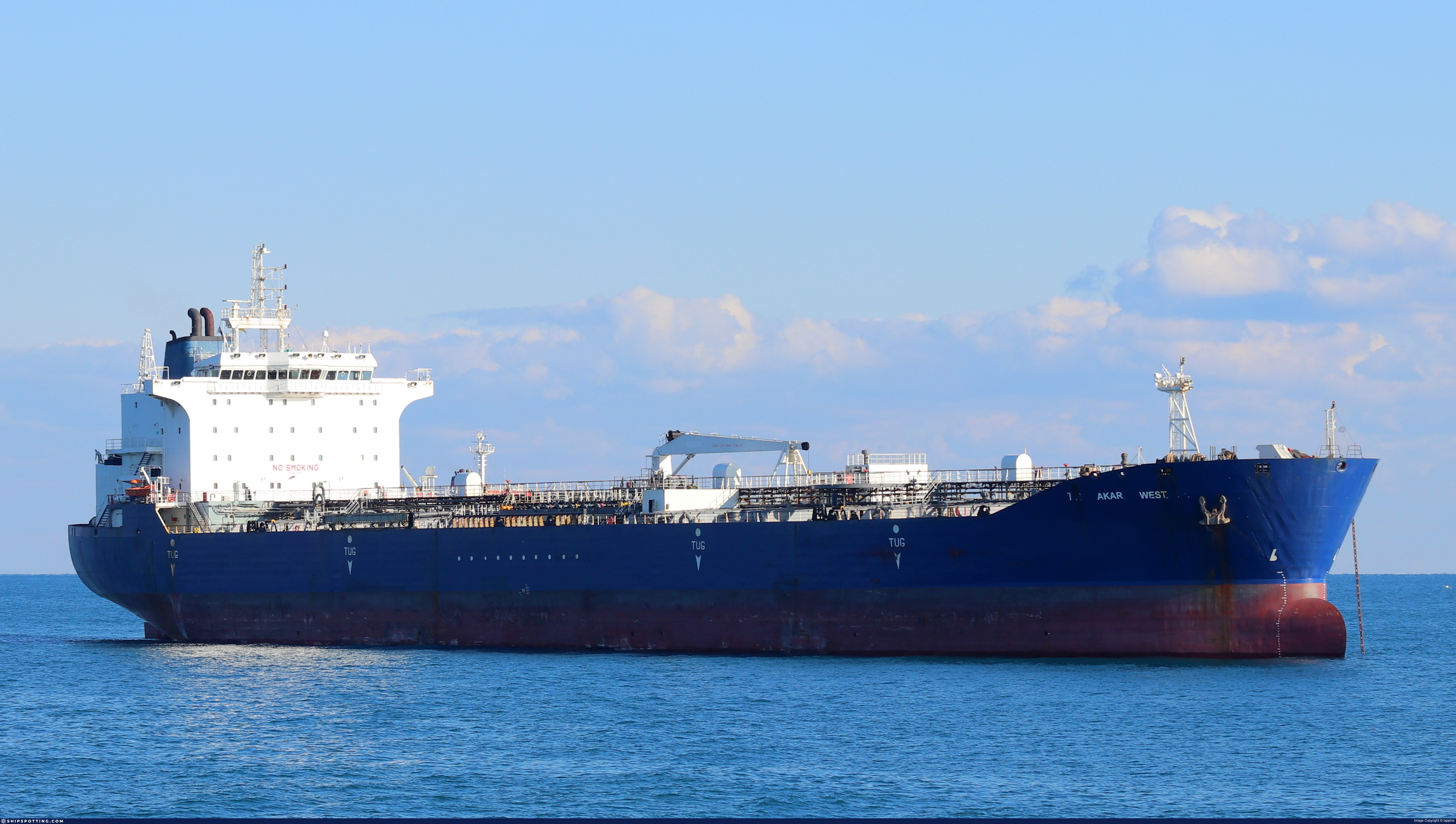
AKAR WEST

IMO 9258167

Vessel information

Vessel Name AKAR WEST View name history 📜
IMO Number 9258167
MMSI 629009578
Vessel Type Oil Products Tanker | Navire-citerne pour produits pétroliers
Flag 🇨🇲 Cameroon View flag history 📜
Call Sign C5J680
Gross Tonnage 27,725 GT
Year Built 2003

Sanctioned by

Company & Ownership

🏢
Sapphire Maritime Ltd
IMO Company: 0049662
Address C/O: Golden Gate Ship Management Ltd Blok N, Apartmani A, Loft Residence, Buyukdere Caddesi 201/40, Esentepe Mah, Sisli, Istanbul, Turkey.
Status Active
Fleet 1.0 owner, 0.0 operator, 0.0 manager, 0.0 beneficial

Management & Operations

ISM Manager
AURINA DENIZCILIK VE TICARET
Ic Kapi 188, Quasar 76, Buyukdere Caddesi Fulya Mah, Sisli, 34381, Istanbul, Turkey.
Commercial Manager
WESTANKER DENIZCILIK VE TIC
A Blok, Loft Residance, Buyukdere Caddesi 201/40, Esentepe Mah, Sisli, Istanbul, Turkey.
Registered Owner
SAPPHIRE MARITIME LTD
C/O: Golden Gate Ship Management Ltd Blok N, Apartmani A, Loft Residence, Buyukdere Caddesi 201/40, Esentepe Mah, Sisli, Istanbul, Turkey.

Classification & Safety

Current Classification
Indian Register of Shipping (IACS) Delivered

Port State Control (PSC) Inspections

⚠️
Risk Level
LOW
Last 36 Months
8
Inspections
Last Inspection
📍 Tuapse
📅 2026-03-16

Survey Renewal & Certificates

Code Type Issuer Issued Expires
507 International Sewage Pollution Prevention Indian Register of Shipping (150) 18/11/2024 20/11/2028
505 International Oil Pollution Prevention (IOPP) Indian Register of Shipping (150) 16/09/2025 20/11/2028

Programs & Notes

EU Russia Sanctions – Shadow Fleet | AU vessel designations (DFAT) | SEMA (Canada) — vessel designations | The Russia (Sanctions) (EU Exit) Regulations 2019

DateOfListing: 2025-07-20 || DateDesignated: 2025-05-09 | Shipping sanctions: (see “Other information”) | Shipping sanctions: a specified ship is prohibited from being provided with access to or having its master or pilot cause it to enter a port in the UK, may have its registration on the UK Ship Register terminated, and a master or pilot of a specified ship may be given a port barring direction, a detention direction, and a port entry direction or a movement direction. | IMO 9258167 (“AKAR WEST”) is involved in activity whose object or effect is to destabilise Ukraine or undermine or threaten the territorial integrity, sovereignty or independence of Ukraine or to obtain a benefit from or support the Government of Russia. Namely, AKAR WEST is involved in carrying oil or oil products that originated in Russia from Russia to a third country.

Vessel Changes

6 changes

AIS Events

50 events detected • 3 zones • Last: Jun 3, 2026

Sts🛰️⏳ Eastern Mediterranean Surveillance Zone Jun 3, 2026 11:57 UTC 95/100
Vessel A: AKAR WEST (AKAR WEST) CAMEROON
Vessel B: IMO 9674713 (HIGH FREEDOM) Liberia
  • Minimum Distance: 5 meters
  • Average Distance: 7 meters
  • Duration: 2h 35m
  • Period: 2026-06-03T11:57:12+00:00 to 2026-06-03T14:33:08+00:00
  • Vessel A Avg Speed: 0.1 knots
  • Vessel B Avg Speed: 0.0 knots
  • Zone: Eastern Mediterranean Surveillance Zone

Confidence Analysis

Score: 95/100

High-confidence STS candidate. Two tankers (AKAR WEST and HIGH FREEDOM) maintained close proximity (min 5m, avg 7m) for 156 minutes. Both vessels were slow-moving (avg speeds 0.1 and 0.0 knots). The stable separation distance suggests deliberate parallel positioning typical of cargo transfer. Event occurred in Eastern Mediterranean Surveillance Zone, a known STS activity area.

View scoring breakdown
FactorScoreDetail
Distance Tightness25/25Min distance 5m, avg 7m
Duration25/25Duration 156 minutes
Speed Stability20/20both nearly stationary; very stable speeds
Distance Consistency15/15Distance variance ±4m
Isolation5/10Isolation data not available
Context5/5In monitored zone: Eastern Mediterranean Surveillance Zone

🛰️ Satellite Corroboration

SAR Pending

Satellite imagery search queued

Show Raw Evidence JSON
{
    "vessel_a": {
        "mmsi": 613612000,
        "imo": 9258167,
        "name": "AKAR WEST",
        "flag": "CAMEROON"
    },
    "vessel_b": {
        "mmsi": 636022700,
        "imo": 9674713,
        "name": "HIGH FREEDOM",
        "flag": "Liberia"
    },
    "min_distance_m": 4.5999999999999996447286321199499070644378662109375,
    "avg_distance_m": 7.20000000000000017763568394002504646778106689453125,
    "distance_consistency_m": 3.70000000000000017763568394002504646778106689453125,
    "duration_minutes": 155.900000000000005684341886080801486968994140625,
    "overlap_duration_s": 9356,
    "speed_a_avg": 0.05000000000000000277555756156289135105907917022705078125,
    "speed_a_std": 0.070000000000000006661338147750939242541790008544921875,
    "speed_b_avg": 0,
    "speed_b_std": 0,
    "speed_summary": {
        "vessel_a": {
            "avg_sog": 0.05000000000000000277555756156289135105907917022705078125,
            "max_sog": 0.1000000000000000055511151231257827021181583404541015625
        },
        "vessel_b": {
            "avg_sog": 0,
            "max_sog": 0
        }
    },
    "time_window": {
        "start": "2026-06-03T11:57:12+00:00",
        "end": "2026-06-03T14:33:08+00:00"
    },
    "points_count": {
        "vessel_a": 2,
        "vessel_b": 2
    },
    "zone_id": "discovered_138",
    "zone_name": "Eastern Mediterranean Surveillance Zone",
    "score": {
        "value": 95,
        "components": {
            "distance_tightness": {
                "score": 25,
                "max": 25,
                "detail": "Min distance 5m, avg 7m"
            },
            "duration": {
                "score": 25,
                "max": 25,
                "detail": "Duration 156 minutes"
            },
            "speed_stability": {
                "score": 20,
                "max": 20,
                "detail": "both nearly stationary; very stable speeds"
            },
            "distance_consistency": {
                "score": 15,
                "max": 15,
                "detail": "Distance variance \u00b14m"
            },
            "isolation": {
                "score": 5,
                "max": 10,
                "detail": "Isolation data not available"
            },
            "context": {
                "score": 5,
                "max": 5,
                "detail": "In monitored zone: Eastern Mediterranean Surveillance Zone"
            }
        },
        "summary": "High-confidence STS candidate. Two tankers (AKAR WEST and HIGH FREEDOM) maintained close proximity (min 5m, avg 7m) for 156 minutes. Both vessels were slow-moving (avg speeds 0.1 and 0.0 knots). The stable separation distance suggests deliberate parallel positioning typical of cargo transfer. Event occurred in Eastern Mediterranean Surveillance Zone, a known STS activity area."
    },
    "sar": {
        "status": "pending"
    }
}

Methodology: 2026.01.18

Sts🛰️⏳ Eastern Mediterranean Surveillance Zone Jun 3, 2026 11:57 UTC 95/100
Vessel A: AKAR WEST (AKAR WEST) CAMEROON
Vessel B: HALCYON (SINO STAR) SIERRA LEONE
  • Minimum Distance: 7 meters
  • Average Distance: 8 meters
  • Duration: 2h 35m
  • Period: 2026-06-03T11:57:12+00:00 to 2026-06-03T14:33:08+00:00
  • Vessel A Avg Speed: 0.1 knots
  • Vessel B Avg Speed: 0.0 knots
  • Zone: Eastern Mediterranean Surveillance Zone

Confidence Analysis

Score: 95/100

High-confidence STS candidate. Two tankers (AKAR WEST and SINO STAR) maintained close proximity (min 7m, avg 8m) for 156 minutes. Both vessels were slow-moving (avg speeds 0.1 and 0.0 knots). The stable separation distance suggests deliberate parallel positioning typical of cargo transfer. Event occurred in Eastern Mediterranean Surveillance Zone, a known STS activity area.

View scoring breakdown
FactorScoreDetail
Distance Tightness25/25Min distance 7m, avg 8m
Duration25/25Duration 156 minutes
Speed Stability20/20both nearly stationary; very stable speeds
Distance Consistency15/15Distance variance ±1m
Isolation5/10Isolation data not available
Context5/5In monitored zone: Eastern Mediterranean Surveillance Zone

🛰️ Satellite Corroboration

SAR Pending

Satellite imagery search queued

Show Raw Evidence JSON
{
    "vessel_a": {
        "mmsi": 613612000,
        "imo": 9258167,
        "name": "AKAR WEST",
        "flag": "CAMEROON"
    },
    "vessel_b": {
        "mmsi": 667002309,
        "imo": 9263693,
        "name": "SINO STAR",
        "flag": "SIERRA LEONE"
    },
    "min_distance_m": 7.29999999999999982236431605997495353221893310546875,
    "avg_distance_m": 8.199999999999999289457264239899814128875732421875,
    "distance_consistency_m": 1.3000000000000000444089209850062616169452667236328125,
    "duration_minutes": 155.900000000000005684341886080801486968994140625,
    "overlap_duration_s": 9356,
    "speed_a_avg": 0.05000000000000000277555756156289135105907917022705078125,
    "speed_a_std": 0.070000000000000006661338147750939242541790008544921875,
    "speed_b_avg": 0,
    "speed_b_std": 0,
    "speed_summary": {
        "vessel_a": {
            "avg_sog": 0.05000000000000000277555756156289135105907917022705078125,
            "max_sog": 0.1000000000000000055511151231257827021181583404541015625
        },
        "vessel_b": {
            "avg_sog": 0,
            "max_sog": 0
        }
    },
    "time_window": {
        "start": "2026-06-03T11:57:12+00:00",
        "end": "2026-06-03T14:33:08+00:00"
    },
    "points_count": {
        "vessel_a": 2,
        "vessel_b": 2
    },
    "zone_id": "discovered_138",
    "zone_name": "Eastern Mediterranean Surveillance Zone",
    "score": {
        "value": 95,
        "components": {
            "distance_tightness": {
                "score": 25,
                "max": 25,
                "detail": "Min distance 7m, avg 8m"
            },
            "duration": {
                "score": 25,
                "max": 25,
                "detail": "Duration 156 minutes"
            },
            "speed_stability": {
                "score": 20,
                "max": 20,
                "detail": "both nearly stationary; very stable speeds"
            },
            "distance_consistency": {
                "score": 15,
                "max": 15,
                "detail": "Distance variance \u00b11m"
            },
            "isolation": {
                "score": 5,
                "max": 10,
                "detail": "Isolation data not available"
            },
            "context": {
                "score": 5,
                "max": 5,
                "detail": "In monitored zone: Eastern Mediterranean Surveillance Zone"
            }
        },
        "summary": "High-confidence STS candidate. Two tankers (AKAR WEST and SINO STAR) maintained close proximity (min 7m, avg 8m) for 156 minutes. Both vessels were slow-moving (avg speeds 0.1 and 0.0 knots). The stable separation distance suggests deliberate parallel positioning typical of cargo transfer. Event occurred in Eastern Mediterranean Surveillance Zone, a known STS activity area."
    },
    "sar": {
        "status": "pending"
    }
}

Methodology: 2026.01.18

Sts🛰️⏳ Eastern Mediterranean Surveillance Zone Jun 3, 2026 11:49 UTC 92/100
Vessel A: AKAR WEST (AKAR WEST) CAMEROON
Vessel B: Georgy Maslov (GEORGY MASLOV) RUSSIA
  • Minimum Distance: 2 meters
  • Average Distance: 4 meters
  • Duration: 2h 43m
  • Period: 2026-06-03T11:49:11+00:00 to 2026-06-03T14:33:08+00:00
  • Vessel A Avg Speed: 0.0 knots
  • Vessel B Avg Speed: 0.3 knots
  • Zone: Eastern Mediterranean Surveillance Zone

Confidence Analysis

Score: 92/100

High-confidence STS candidate. Two tankers (AKAR WEST and GEORGY MASLOV) maintained close proximity (min 2m, avg 4m) for 164 minutes. Both vessels were slow-moving (avg speeds 0.0 and 0.3 knots). The stable separation distance suggests deliberate parallel positioning typical of cargo transfer. Event occurred in Eastern Mediterranean Surveillance Zone, a known STS activity area.

View scoring breakdown
FactorScoreDetail
Distance Tightness25/25Min distance 2m, avg 4m
Duration25/25Duration 164 minutes
Speed Stability17/20both nearly stationary; stable speeds
Distance Consistency15/15Distance variance ±2m
Isolation5/10Isolation data not available
Context5/5In monitored zone: Eastern Mediterranean Surveillance Zone

🛰️ Satellite Corroboration

SAR Pending

Satellite imagery search queued

Show Raw Evidence JSON
{
    "vessel_a": {
        "mmsi": 613612000,
        "imo": 9258167,
        "name": "AKAR WEST",
        "flag": "CAMEROON"
    },
    "vessel_b": {
        "mmsi": 273259730,
        "imo": 9610793,
        "name": "GEORGY MASLOV",
        "flag": "RUSSIA"
    },
    "min_distance_m": 1.600000000000000088817841970012523233890533447265625,
    "avg_distance_m": 3.899999999999999911182158029987476766109466552734375,
    "distance_consistency_m": 2,
    "duration_minutes": 163.900000000000005684341886080801486968994140625,
    "overlap_duration_s": 9837,
    "speed_a_avg": 0.0299999999999999988897769753748434595763683319091796875,
    "speed_a_std": 0.059999999999999997779553950749686919152736663818359375,
    "speed_b_avg": 0.299999999999999988897769753748434595763683319091796875,
    "speed_b_std": 0.35999999999999998667732370449812151491641998291015625,
    "speed_summary": {
        "vessel_a": {
            "avg_sog": 0.0299999999999999988897769753748434595763683319091796875,
            "max_sog": 0.1000000000000000055511151231257827021181583404541015625
        },
        "vessel_b": {
            "avg_sog": 0.299999999999999988897769753748434595763683319091796875,
            "max_sog": 0.6999999999999999555910790149937383830547332763671875
        }
    },
    "time_window": {
        "start": "2026-06-03T11:49:11+00:00",
        "end": "2026-06-03T14:33:08+00:00"
    },
    "points_count": {
        "vessel_a": 3,
        "vessel_b": 3
    },
    "zone_id": "discovered_138",
    "zone_name": "Eastern Mediterranean Surveillance Zone",
    "score": {
        "value": 92,
        "components": {
            "distance_tightness": {
                "score": 25,
                "max": 25,
                "detail": "Min distance 2m, avg 4m"
            },
            "duration": {
                "score": 25,
                "max": 25,
                "detail": "Duration 164 minutes"
            },
            "speed_stability": {
                "score": 17,
                "max": 20,
                "detail": "both nearly stationary; stable speeds"
            },
            "distance_consistency": {
                "score": 15,
                "max": 15,
                "detail": "Distance variance \u00b12m"
            },
            "isolation": {
                "score": 5,
                "max": 10,
                "detail": "Isolation data not available"
            },
            "context": {
                "score": 5,
                "max": 5,
                "detail": "In monitored zone: Eastern Mediterranean Surveillance Zone"
            }
        },
        "summary": "High-confidence STS candidate. Two tankers (AKAR WEST and GEORGY MASLOV) maintained close proximity (min 2m, avg 4m) for 164 minutes. Both vessels were slow-moving (avg speeds 0.0 and 0.3 knots). The stable separation distance suggests deliberate parallel positioning typical of cargo transfer. Event occurred in Eastern Mediterranean Surveillance Zone, a known STS activity area."
    },
    "sar": {
        "status": "pending"
    }
}

Methodology: 2026.01.18

Sts🛰️⏳ Eastern Mediterranean Surveillance Zone Jun 3, 2026 11:49 UTC 95/100
Vessel A: AKAR WEST (AKAR WEST) CAMEROON
Vessel B: JASPER (JASPER) CAMEROON
  • Minimum Distance: 2 meters
  • Average Distance: 5 meters
  • Duration: 2h 43m
  • Period: 2026-06-03T11:49:11+00:00 to 2026-06-03T14:33:08+00:00
  • Vessel A Avg Speed: 0.0 knots
  • Vessel B Avg Speed: 0.0 knots
  • Zone: Eastern Mediterranean Surveillance Zone

Confidence Analysis

Score: 95/100

High-confidence STS candidate. Two tankers (AKAR WEST and JASPER) maintained close proximity (min 2m, avg 5m) for 164 minutes. Both vessels were slow-moving (avg speeds 0.0 and 0.0 knots). The stable separation distance suggests deliberate parallel positioning typical of cargo transfer. Event occurred in Eastern Mediterranean Surveillance Zone, a known STS activity area.

View scoring breakdown
FactorScoreDetail
Distance Tightness25/25Min distance 2m, avg 5m
Duration25/25Duration 164 minutes
Speed Stability20/20both nearly stationary; very stable speeds
Distance Consistency15/15Distance variance ±5m
Isolation5/10Isolation data not available
Context5/5In monitored zone: Eastern Mediterranean Surveillance Zone

🛰️ Satellite Corroboration

SAR Pending

Satellite imagery search queued

Show Raw Evidence JSON
{
    "vessel_a": {
        "mmsi": 613612000,
        "imo": 9258167,
        "name": "AKAR WEST",
        "flag": "CAMEROON"
    },
    "vessel_b": {
        "mmsi": 613472020,
        "imo": 9299886,
        "name": "JASPER",
        "flag": "CAMEROON"
    },
    "min_distance_m": 1.5,
    "avg_distance_m": 5.0999999999999996447286321199499070644378662109375,
    "distance_consistency_m": 4.5999999999999996447286321199499070644378662109375,
    "duration_minutes": 163.900000000000005684341886080801486968994140625,
    "overlap_duration_s": 9837,
    "speed_a_avg": 0.0299999999999999988897769753748434595763683319091796875,
    "speed_a_std": 0.059999999999999997779553950749686919152736663818359375,
    "speed_b_avg": 0,
    "speed_b_std": 0,
    "speed_summary": {
        "vessel_a": {
            "avg_sog": 0.0299999999999999988897769753748434595763683319091796875,
            "max_sog": 0.1000000000000000055511151231257827021181583404541015625
        },
        "vessel_b": {
            "avg_sog": 0,
            "max_sog": 0
        }
    },
    "time_window": {
        "start": "2026-06-03T11:49:11+00:00",
        "end": "2026-06-03T14:33:08+00:00"
    },
    "points_count": {
        "vessel_a": 3,
        "vessel_b": 3
    },
    "zone_id": "discovered_138",
    "zone_name": "Eastern Mediterranean Surveillance Zone",
    "score": {
        "value": 95,
        "components": {
            "distance_tightness": {
                "score": 25,
                "max": 25,
                "detail": "Min distance 2m, avg 5m"
            },
            "duration": {
                "score": 25,
                "max": 25,
                "detail": "Duration 164 minutes"
            },
            "speed_stability": {
                "score": 20,
                "max": 20,
                "detail": "both nearly stationary; very stable speeds"
            },
            "distance_consistency": {
                "score": 15,
                "max": 15,
                "detail": "Distance variance \u00b15m"
            },
            "isolation": {
                "score": 5,
                "max": 10,
                "detail": "Isolation data not available"
            },
            "context": {
                "score": 5,
                "max": 5,
                "detail": "In monitored zone: Eastern Mediterranean Surveillance Zone"
            }
        },
        "summary": "High-confidence STS candidate. Two tankers (AKAR WEST and JASPER) maintained close proximity (min 2m, avg 5m) for 164 minutes. Both vessels were slow-moving (avg speeds 0.0 and 0.0 knots). The stable separation distance suggests deliberate parallel positioning typical of cargo transfer. Event occurred in Eastern Mediterranean Surveillance Zone, a known STS activity area."
    },
    "sar": {
        "status": "pending"
    }
}

Methodology: 2026.01.18

Sts🛰️⏳ Eastern Mediterranean Surveillance Zone Jun 3, 2026 11:49 UTC 95/100
Vessel A: AKAR WEST (AKAR WEST) CAMEROON
Vessel B: Hyperion (HYPERION) Russia
  • Minimum Distance: 3 meters
  • Average Distance: 8 meters
  • Duration: 2h 43m
  • Period: 2026-06-03T11:49:11+00:00 to 2026-06-03T14:33:08+00:00
  • Vessel A Avg Speed: 0.0 knots
  • Vessel B Avg Speed: 0.0 knots
  • Zone: Eastern Mediterranean Surveillance Zone

Confidence Analysis

Score: 95/100

High-confidence STS candidate. Two tankers (AKAR WEST and HYPERION) maintained close proximity (min 2m, avg 8m) for 164 minutes. Both vessels were slow-moving (avg speeds 0.0 and 0.0 knots). The stable separation distance suggests deliberate parallel positioning typical of cargo transfer. Event occurred in Eastern Mediterranean Surveillance Zone, a known STS activity area.

View scoring breakdown
FactorScoreDetail
Distance Tightness25/25Min distance 2m, avg 8m
Duration25/25Duration 164 minutes
Speed Stability20/20both nearly stationary; very stable speeds
Distance Consistency15/15Distance variance ±6m
Isolation5/10Isolation data not available
Context5/5In monitored zone: Eastern Mediterranean Surveillance Zone

🛰️ Satellite Corroboration

SAR Pending

Satellite imagery search queued

Show Raw Evidence JSON
{
    "vessel_a": {
        "mmsi": 613612000,
        "imo": 9258167,
        "name": "AKAR WEST",
        "flag": "CAMEROON"
    },
    "vessel_b": {
        "mmsi": 273278750,
        "imo": 9322968,
        "name": "HYPERION",
        "flag": "Russia"
    },
    "min_distance_m": 2.5,
    "avg_distance_m": 8,
    "distance_consistency_m": 5.9000000000000003552713678800500929355621337890625,
    "duration_minutes": 163.900000000000005684341886080801486968994140625,
    "overlap_duration_s": 9837,
    "speed_a_avg": 0.0299999999999999988897769753748434595763683319091796875,
    "speed_a_std": 0.059999999999999997779553950749686919152736663818359375,
    "speed_b_avg": 0,
    "speed_b_std": 0,
    "speed_summary": {
        "vessel_a": {
            "avg_sog": 0.0299999999999999988897769753748434595763683319091796875,
            "max_sog": 0.1000000000000000055511151231257827021181583404541015625
        },
        "vessel_b": {
            "avg_sog": 0,
            "max_sog": 0
        }
    },
    "time_window": {
        "start": "2026-06-03T11:49:11+00:00",
        "end": "2026-06-03T14:33:08+00:00"
    },
    "points_count": {
        "vessel_a": 3,
        "vessel_b": 3
    },
    "zone_id": "discovered_138",
    "zone_name": "Eastern Mediterranean Surveillance Zone",
    "score": {
        "value": 95,
        "components": {
            "distance_tightness": {
                "score": 25,
                "max": 25,
                "detail": "Min distance 2m, avg 8m"
            },
            "duration": {
                "score": 25,
                "max": 25,
                "detail": "Duration 164 minutes"
            },
            "speed_stability": {
                "score": 20,
                "max": 20,
                "detail": "both nearly stationary; very stable speeds"
            },
            "distance_consistency": {
                "score": 15,
                "max": 15,
                "detail": "Distance variance \u00b16m"
            },
            "isolation": {
                "score": 5,
                "max": 10,
                "detail": "Isolation data not available"
            },
            "context": {
                "score": 5,
                "max": 5,
                "detail": "In monitored zone: Eastern Mediterranean Surveillance Zone"
            }
        },
        "summary": "High-confidence STS candidate. Two tankers (AKAR WEST and HYPERION) maintained close proximity (min 2m, avg 8m) for 164 minutes. Both vessels were slow-moving (avg speeds 0.0 and 0.0 knots). The stable separation distance suggests deliberate parallel positioning typical of cargo transfer. Event occurred in Eastern Mediterranean Surveillance Zone, a known STS activity area."
    },
    "sar": {
        "status": "pending"
    }
}

Methodology: 2026.01.18

Sts🛰️⏳ Eastern Mediterranean Surveillance Zone Jun 3, 2026 11:45 UTC 92/100
Vessel A: AKAR WEST (AKAR WEST) CAMEROON
Vessel B: IMO 9611541 (THALIA) Liberia
  • Minimum Distance: 2 meters
  • Average Distance: 19 meters
  • Duration: 2h 47m
  • Period: 2026-06-03T11:45:25+00:00 to 2026-06-03T14:33:08+00:00
  • Vessel A Avg Speed: 0.0 knots
  • Vessel B Avg Speed: 0.0 knots
  • Zone: Eastern Mediterranean Surveillance Zone

Confidence Analysis

Score: 92/100

High-confidence STS candidate. Two tankers (AKAR WEST and THALIA) maintained close proximity (min 2m, avg 19m) for 168 minutes. Both vessels were slow-moving (avg speeds 0.0 and 0.0 knots). The stable separation distance suggests deliberate parallel positioning typical of cargo transfer. Event occurred in Eastern Mediterranean Surveillance Zone, a known STS activity area.

View scoring breakdown
FactorScoreDetail
Distance Tightness25/25Min distance 2m, avg 19m
Duration25/25Duration 168 minutes
Speed Stability20/20both nearly stationary; very stable speeds
Distance Consistency12/15Distance variance ±34m
Isolation5/10Isolation data not available
Context5/5In monitored zone: Eastern Mediterranean Surveillance Zone

🛰️ Satellite Corroboration

SAR Pending

Satellite imagery search queued

Show Raw Evidence JSON
{
    "vessel_a": {
        "mmsi": 613612000,
        "imo": 9258167,
        "name": "AKAR WEST",
        "flag": "CAMEROON"
    },
    "vessel_b": {
        "mmsi": 636015372,
        "imo": 9611541,
        "name": "THALIA",
        "flag": "Liberia"
    },
    "min_distance_m": 1.5,
    "avg_distance_m": 18.89999999999999857891452847979962825775146484375,
    "distance_consistency_m": 33.5,
    "duration_minutes": 167.69999999999998863131622783839702606201171875,
    "overlap_duration_s": 10063,
    "speed_a_avg": 0.0299999999999999988897769753748434595763683319091796875,
    "speed_a_std": 0.05000000000000000277555756156289135105907917022705078125,
    "speed_b_avg": 0,
    "speed_b_std": 0,
    "speed_summary": {
        "vessel_a": {
            "avg_sog": 0.0299999999999999988897769753748434595763683319091796875,
            "max_sog": 0.1000000000000000055511151231257827021181583404541015625
        },
        "vessel_b": {
            "avg_sog": 0,
            "max_sog": 0
        }
    },
    "time_window": {
        "start": "2026-06-03T11:45:25+00:00",
        "end": "2026-06-03T14:33:08+00:00"
    },
    "points_count": {
        "vessel_a": 4,
        "vessel_b": 4
    },
    "zone_id": "discovered_138",
    "zone_name": "Eastern Mediterranean Surveillance Zone",
    "score": {
        "value": 92,
        "components": {
            "distance_tightness": {
                "score": 25,
                "max": 25,
                "detail": "Min distance 2m, avg 19m"
            },
            "duration": {
                "score": 25,
                "max": 25,
                "detail": "Duration 168 minutes"
            },
            "speed_stability": {
                "score": 20,
                "max": 20,
                "detail": "both nearly stationary; very stable speeds"
            },
            "distance_consistency": {
                "score": 12,
                "max": 15,
                "detail": "Distance variance \u00b134m"
            },
            "isolation": {
                "score": 5,
                "max": 10,
                "detail": "Isolation data not available"
            },
            "context": {
                "score": 5,
                "max": 5,
                "detail": "In monitored zone: Eastern Mediterranean Surveillance Zone"
            }
        },
        "summary": "High-confidence STS candidate. Two tankers (AKAR WEST and THALIA) maintained close proximity (min 2m, avg 19m) for 168 minutes. Both vessels were slow-moving (avg speeds 0.0 and 0.0 knots). The stable separation distance suggests deliberate parallel positioning typical of cargo transfer. Event occurred in Eastern Mediterranean Surveillance Zone, a known STS activity area."
    },
    "sar": {
        "status": "pending"
    }
}

Methodology: 2026.01.18

Sts🛰️⏳ Eastern Mediterranean Surveillance Zone Jun 3, 2026 11:45 UTC 89/100
Vessel A: AKAR WEST (AKAR WEST) CAMEROON
Vessel B: IMO 9354521 (ANHONA) BELIZE
  • Minimum Distance: 2 meters
  • Average Distance: 14 meters
  • Duration: 2h 47m
  • Period: 2026-06-03T11:45:25+00:00 to 2026-06-03T14:33:08+00:00
  • Vessel A Avg Speed: 0.0 knots
  • Vessel B Avg Speed: 0.3 knots
  • Zone: Eastern Mediterranean Surveillance Zone

Confidence Analysis

Score: 89/100

High-confidence STS candidate. Two tankers (AKAR WEST and ANHONA) maintained close proximity (min 2m, avg 14m) for 168 minutes. Both vessels were slow-moving (avg speeds 0.0 and 0.3 knots). The stable separation distance suggests deliberate parallel positioning typical of cargo transfer. Event occurred in Eastern Mediterranean Surveillance Zone, a known STS activity area.

View scoring breakdown
FactorScoreDetail
Distance Tightness25/25Min distance 2m, avg 14m
Duration25/25Duration 168 minutes
Speed Stability14/20both nearly stationary; somewhat variable speeds
Distance Consistency15/15Distance variance ±20m
Isolation5/10Isolation data not available
Context5/5In monitored zone: Eastern Mediterranean Surveillance Zone

🛰️ Satellite Corroboration

SAR Pending

Satellite imagery search queued

Show Raw Evidence JSON
{
    "vessel_a": {
        "mmsi": 613612000,
        "imo": 9258167,
        "name": "AKAR WEST",
        "flag": "CAMEROON"
    },
    "vessel_b": {
        "mmsi": 312171000,
        "imo": 9354521,
        "name": "ANHONA",
        "flag": "BELIZE"
    },
    "min_distance_m": 1.8000000000000000444089209850062616169452667236328125,
    "avg_distance_m": 13.800000000000000710542735760100185871124267578125,
    "distance_consistency_m": 20.10000000000000142108547152020037174224853515625,
    "duration_minutes": 167.69999999999998863131622783839702606201171875,
    "overlap_duration_s": 10063,
    "speed_a_avg": 0.0299999999999999988897769753748434595763683319091796875,
    "speed_a_std": 0.05000000000000000277555756156289135105907917022705078125,
    "speed_b_avg": 0.299999999999999988897769753748434595763683319091796875,
    "speed_b_std": 0.59999999999999997779553950749686919152736663818359375,
    "speed_summary": {
        "vessel_a": {
            "avg_sog": 0.0299999999999999988897769753748434595763683319091796875,
            "max_sog": 0.1000000000000000055511151231257827021181583404541015625
        },
        "vessel_b": {
            "avg_sog": 0.299999999999999988897769753748434595763683319091796875,
            "max_sog": 1.1999999999999999555910790149937383830547332763671875
        }
    },
    "time_window": {
        "start": "2026-06-03T11:45:25+00:00",
        "end": "2026-06-03T14:33:08+00:00"
    },
    "points_count": {
        "vessel_a": 4,
        "vessel_b": 4
    },
    "zone_id": "discovered_138",
    "zone_name": "Eastern Mediterranean Surveillance Zone",
    "score": {
        "value": 89,
        "components": {
            "distance_tightness": {
                "score": 25,
                "max": 25,
                "detail": "Min distance 2m, avg 14m"
            },
            "duration": {
                "score": 25,
                "max": 25,
                "detail": "Duration 168 minutes"
            },
            "speed_stability": {
                "score": 14,
                "max": 20,
                "detail": "both nearly stationary; somewhat variable speeds"
            },
            "distance_consistency": {
                "score": 15,
                "max": 15,
                "detail": "Distance variance \u00b120m"
            },
            "isolation": {
                "score": 5,
                "max": 10,
                "detail": "Isolation data not available"
            },
            "context": {
                "score": 5,
                "max": 5,
                "detail": "In monitored zone: Eastern Mediterranean Surveillance Zone"
            }
        },
        "summary": "High-confidence STS candidate. Two tankers (AKAR WEST and ANHONA) maintained close proximity (min 2m, avg 14m) for 168 minutes. Both vessels were slow-moving (avg speeds 0.0 and 0.3 knots). The stable separation distance suggests deliberate parallel positioning typical of cargo transfer. Event occurred in Eastern Mediterranean Surveillance Zone, a known STS activity area."
    },
    "sar": {
        "status": "pending"
    }
}

Methodology: 2026.01.18

Sts🛰️⏳ Eastern Mediterranean Surveillance Zone Jun 3, 2026 11:35 UTC 72/100
Vessel A: IMO 9724714 (ASTROLIGHT) Marshall Is
Vessel B: AKAR WEST (AKAR WEST) CAMEROON
  • Minimum Distance: 0 meters
  • Average Distance: 2 meters
  • Duration: 31 minutes
  • Period: 2026-06-03T11:35:48+00:00 to 2026-06-03T12:06:47+00:00
  • Vessel A Avg Speed: 0.1 knots
  • Vessel B Avg Speed: 0.0 knots
  • Zone: Eastern Mediterranean Surveillance Zone

Confidence Analysis

Score: 72/100

Moderate-confidence STS candidate. Two tankers (ASTROLIGHT and AKAR WEST) maintained close proximity (min 0m, avg 2m) for 31 minutes. Both vessels were slow-moving (avg speeds 0.1 and 0.0 knots). The stable separation distance suggests deliberate parallel positioning typical of cargo transfer. Event occurred in Eastern Mediterranean Surveillance Zone, a known STS activity area.

View scoring breakdown
FactorScoreDetail
Distance Tightness25/25Min distance 0m, avg 2m
Duration5/25Duration 31 minutes
Speed Stability17/20both nearly stationary; stable speeds
Distance Consistency15/15Distance variance ±1m
Isolation5/10Isolation data not available
Context5/5In monitored zone: Eastern Mediterranean Surveillance Zone

🛰️ Satellite Corroboration

SAR Pending

Satellite imagery search queued

Show Raw Evidence JSON
{
    "vessel_a": {
        "mmsi": 538011848,
        "imo": 9724714,
        "name": "ASTROLIGHT",
        "flag": "Marshall Is"
    },
    "vessel_b": {
        "mmsi": 613612000,
        "imo": 9258167,
        "name": "AKAR WEST",
        "flag": "CAMEROON"
    },
    "min_distance_m": 0.200000000000000011102230246251565404236316680908203125,
    "avg_distance_m": 2.399999999999999911182158029987476766109466552734375,
    "distance_consistency_m": 1,
    "duration_minutes": 31,
    "overlap_duration_s": 1859,
    "speed_a_avg": 0.13000000000000000444089209850062616169452667236328125,
    "speed_a_std": 0.419999999999999984456877655247808434069156646728515625,
    "speed_b_avg": 0.0200000000000000004163336342344337026588618755340576171875,
    "speed_b_std": 0.040000000000000000832667268468867405317723751068115234375,
    "speed_summary": {
        "vessel_a": {
            "avg_sog": 0.13000000000000000444089209850062616169452667236328125,
            "max_sog": 1.399999999999999911182158029987476766109466552734375
        },
        "vessel_b": {
            "avg_sog": 0.0200000000000000004163336342344337026588618755340576171875,
            "max_sog": 0.1000000000000000055511151231257827021181583404541015625
        }
    },
    "time_window": {
        "start": "2026-06-03T11:35:48+00:00",
        "end": "2026-06-03T12:06:47+00:00"
    },
    "points_count": {
        "vessel_a": 11,
        "vessel_b": 11
    },
    "zone_id": "discovered_138",
    "zone_name": "Eastern Mediterranean Surveillance Zone",
    "score": {
        "value": 72,
        "components": {
            "distance_tightness": {
                "score": 25,
                "max": 25,
                "detail": "Min distance 0m, avg 2m"
            },
            "duration": {
                "score": 5,
                "max": 25,
                "detail": "Duration 31 minutes"
            },
            "speed_stability": {
                "score": 17,
                "max": 20,
                "detail": "both nearly stationary; stable speeds"
            },
            "distance_consistency": {
                "score": 15,
                "max": 15,
                "detail": "Distance variance \u00b11m"
            },
            "isolation": {
                "score": 5,
                "max": 10,
                "detail": "Isolation data not available"
            },
            "context": {
                "score": 5,
                "max": 5,
                "detail": "In monitored zone: Eastern Mediterranean Surveillance Zone"
            }
        },
        "summary": "Moderate-confidence STS candidate. Two tankers (ASTROLIGHT and AKAR WEST) maintained close proximity (min 0m, avg 2m) for 31 minutes. Both vessels were slow-moving (avg speeds 0.1 and 0.0 knots). The stable separation distance suggests deliberate parallel positioning typical of cargo transfer. Event occurred in Eastern Mediterranean Surveillance Zone, a known STS activity area."
    },
    "sar": {
        "status": "pending"
    }
}

Methodology: 2026.01.18

Zone Dwell Eastern Mediterranean Surveillance Zone Jun 3, 2026 11:35 UTC 80.0%
  • Zone: Eastern Mediterranean Surveillance Zone
  • Duration: 2h 57m
  • Data Points: 6 AIS positions
  • Period: 2026-06-03T11:35:47+00:00 to 2026-06-03T14:33:08+00:00
Show Raw Evidence JSON
{
    "zone_id": "discovered_138",
    "zone_name": "Eastern Mediterranean Surveillance Zone",
    "dwell_minutes": 177.30000000000001136868377216160297393798828125,
    "points_in_zone": 6,
    "first_point": {
        "ts": "2026-06-03T11:35:47+00:00",
        "lat": 31.717079999999999273541106958873569965362548828125,
        "lon": 35.99936170000000146274032886140048503875732421875
    },
    "last_point": {
        "ts": "2026-06-03T14:33:08+00:00",
        "lat": 31.717066700000000167847247212193906307220458984375,
        "lon": 35.99944169999999843412297195754945278167724609375
    }
}

Methodology: 2026.01.18

Zone Dwell Eastern Mediterranean Sanctioned Vessel Zone May 19, 2026 15:29 UTC 80.0%
  • Zone: Eastern Mediterranean Sanctioned Vessel Zone
  • Duration: 3h 55m
  • Data Points: 8 AIS positions
  • Period: 2026-05-19T15:29:43+00:00 to 2026-05-19T19:25:35+00:00
Show Raw Evidence JSON
{
    "zone_id": "discovered_018",
    "zone_name": "Eastern Mediterranean Sanctioned Vessel Zone",
    "dwell_minutes": 235.900000000000005684341886080801486968994140625,
    "points_in_zone": 8,
    "first_point": {
        "ts": "2026-05-19T15:29:43+00:00",
        "lat": 31.509271699999999327701516449451446533203125,
        "lon": 32.35791669999999697893144912086427211761474609375
    },
    "last_point": {
        "ts": "2026-05-19T19:25:35+00:00",
        "lat": 31.509613300000001601119947736151516437530517578125,
        "lon": 32.35787830000000298014128929935395717620849609375
    }
}

Methodology: 2026.01.18

Zone Dwell Eastern Mediterranean Sanctioned Vessel Zone May 19, 2026 13:17 UTC 80.0%
  • Zone: Eastern Mediterranean Sanctioned Vessel Zone
  • Duration: 6h 7m
  • Data Points: 9 AIS positions
  • Period: 2026-05-19T13:17:49+00:00 to 2026-05-19T19:25:35+00:00
Show Raw Evidence JSON
{
    "zone_id": "discovered_018",
    "zone_name": "Eastern Mediterranean Sanctioned Vessel Zone",
    "dwell_minutes": 367.80000000000001136868377216160297393798828125,
    "points_in_zone": 9,
    "first_point": {
        "ts": "2026-05-19T13:17:49+00:00",
        "lat": 31.50992169999999958918124320916831493377685546875,
        "lon": 32.35854830000000248446667683310806751251220703125
    },
    "last_point": {
        "ts": "2026-05-19T19:25:35+00:00",
        "lat": 31.509613300000001601119947736151516437530517578125,
        "lon": 32.35787830000000298014128929935395717620849609375
    }
}

Methodology: 2026.01.18

Zone Dwell Eastern Mediterranean Sanctioned Vessel Zone May 19, 2026 10:57 UTC 80.0%
  • Zone: Eastern Mediterranean Sanctioned Vessel Zone
  • Duration: 4h 55m
  • Data Points: 8 AIS positions
  • Period: 2026-05-19T10:57:08+00:00 to 2026-05-19T15:52:14+00:00
Show Raw Evidence JSON
{
    "zone_id": "discovered_018",
    "zone_name": "Eastern Mediterranean Sanctioned Vessel Zone",
    "dwell_minutes": 295.1000000000000227373675443232059478759765625,
    "points_in_zone": 8,
    "first_point": {
        "ts": "2026-05-19T10:57:08+00:00",
        "lat": 31.510733299999998280327417887747287750244140625,
        "lon": 32.35917500000000046611603465862572193145751953125
    },
    "last_point": {
        "ts": "2026-05-19T15:52:14+00:00",
        "lat": 31.509474999999998345856511150486767292022705078125,
        "lon": 32.35782830000000132031345856375992298126220703125
    }
}

Methodology: 2026.01.18

Zone Dwell Eastern Mediterranean Sanctioned Vessel Zone May 18, 2026 15:08 UTC 80.0%
  • Zone: Eastern Mediterranean Sanctioned Vessel Zone
  • Duration: 2h 52m
  • Data Points: 8 AIS positions
  • Period: 2026-05-18T15:08:31+00:00 to 2026-05-18T18:00:30+00:00
Show Raw Evidence JSON
{
    "zone_id": "discovered_018",
    "zone_name": "Eastern Mediterranean Sanctioned Vessel Zone",
    "dwell_minutes": 172,
    "points_in_zone": 8,
    "first_point": {
        "ts": "2026-05-18T15:08:31+00:00",
        "lat": 31.513058300000000855334292282350361347198486328125,
        "lon": 32.355361700000003111199475824832916259765625
    },
    "last_point": {
        "ts": "2026-05-18T18:00:30+00:00",
        "lat": 31.509331700000000608952177572064101696014404296875,
        "lon": 32.35748170000000101254045148380100727081298828125
    }
}

Methodology: 2026.01.18

Zone Dwell Eastern Mediterranean Sanctioned Vessel Zone May 18, 2026 14:02 UTC 80.0%
  • Zone: Eastern Mediterranean Sanctioned Vessel Zone
  • Duration: 3h 58m
  • Data Points: 26 AIS positions
  • Period: 2026-05-18T14:02:23+00:00 to 2026-05-18T18:00:30+00:00
Show Raw Evidence JSON
{
    "zone_id": "discovered_018",
    "zone_name": "Eastern Mediterranean Sanctioned Vessel Zone",
    "dwell_minutes": 238.099999999999994315658113919198513031005859375,
    "points_in_zone": 26,
    "first_point": {
        "ts": "2026-05-18T14:02:23+00:00",
        "lat": 31.5472682999999989306161296553909778594970703125,
        "lon": 32.342001699999997299528331495821475982666015625
    },
    "last_point": {
        "ts": "2026-05-18T18:00:30+00:00",
        "lat": 31.509331700000000608952177572064101696014404296875,
        "lon": 32.35748170000000101254045148380100727081298828125
    }
}

Methodology: 2026.01.18

Zone Dwell Eastern Mediterranean Sanctioned Vessel Zone May 18, 2026 13:19 UTC 80.0%
  • Zone: Eastern Mediterranean Sanctioned Vessel Zone
  • Duration: 4h 40m
  • Data Points: 40 AIS positions
  • Period: 2026-05-18T13:19:55+00:00 to 2026-05-18T18:00:30+00:00
Show Raw Evidence JSON
{
    "zone_id": "discovered_018",
    "zone_name": "Eastern Mediterranean Sanctioned Vessel Zone",
    "dwell_minutes": 280.6000000000000227373675443232059478759765625,
    "points_in_zone": 40,
    "first_point": {
        "ts": "2026-05-18T13:19:55+00:00",
        "lat": 31.5476349999999996498445398174226284027099609375,
        "lon": 32.34293170000000117170202429406344890594482421875
    },
    "last_point": {
        "ts": "2026-05-18T18:00:30+00:00",
        "lat": 31.509331700000000608952177572064101696014404296875,
        "lon": 32.35748170000000101254045148380100727081298828125
    }
}

Methodology: 2026.01.18

Zone Dwell Eastern Mediterranean Sanctioned Vessel Zone May 18, 2026 12:03 UTC 80.0%
  • Zone: Eastern Mediterranean Sanctioned Vessel Zone
  • Duration: 5h 57m
  • Data Points: 52 AIS positions
  • Period: 2026-05-18T12:03:17+00:00 to 2026-05-18T18:00:30+00:00
Show Raw Evidence JSON
{
    "zone_id": "discovered_018",
    "zone_name": "Eastern Mediterranean Sanctioned Vessel Zone",
    "dwell_minutes": 357.19999999999998863131622783839702606201171875,
    "points_in_zone": 52,
    "first_point": {
        "ts": "2026-05-18T12:03:17+00:00",
        "lat": 31.527511700000001582111508469097316265106201171875,
        "lon": 32.37678329999999959909473545849323272705078125
    },
    "last_point": {
        "ts": "2026-05-18T18:00:30+00:00",
        "lat": 31.509331700000000608952177572064101696014404296875,
        "lon": 32.35748170000000101254045148380100727081298828125
    }
}

Methodology: 2026.01.18

Zone Dwell Eastern Mediterranean Sanctioned Vessel Zone May 18, 2026 11:11 UTC 80.0%
  • Zone: Eastern Mediterranean Sanctioned Vessel Zone
  • Duration: 6h 30m
  • Data Points: 61 AIS positions
  • Period: 2026-05-18T11:30:17+00:00 to 2026-05-18T18:00:30+00:00
Show Raw Evidence JSON
{
    "zone_id": "discovered_018",
    "zone_name": "Eastern Mediterranean Sanctioned Vessel Zone",
    "dwell_minutes": 390.19999999999998863131622783839702606201171875,
    "points_in_zone": 61,
    "first_point": {
        "ts": "2026-05-18T11:30:17+00:00",
        "lat": 31.528748300000000170939529198221862316131591796875,
        "lon": 32.3807316999999983408997650258243083953857421875
    },
    "last_point": {
        "ts": "2026-05-18T18:00:30+00:00",
        "lat": 31.509331700000000608952177572064101696014404296875,
        "lon": 32.35748170000000101254045148380100727081298828125
    }
}

Methodology: 2026.01.18

Loiter Eastern Mediterranean Sanctioned Vessel Zone May 18, 2026 10:03 UTC 75.0%
  • Duration: 2h 20m
  • Radius: 823 meters
  • Data Points: 28 AIS positions
  • Centroid: 31.5272, 32.3789
  • Zone: Eastern Mediterranean Sanctioned Vessel Zone
Show Raw Evidence JSON
{
    "radius_m": 823.299999999999954525264911353588104248046875,
    "duration_minutes": 140.19999999999998863131622783839702606201171875,
    "points": 28,
    "centroid": {
        "lat": 31.527176189285711416232516057789325714111328125,
        "lon": 32.37891041785714918432859121821820735931396484375
    },
    "bbox": {
        "min_lat": 31.524608300000000582485881750471889972686767578125,
        "min_lon": 32.37037500000000278532752417959272861480712890625,
        "max_lat": 31.529481700000001609396349522285163402557373046875,
        "max_lon": 32.38206170000000128084138850681483745574951171875
    },
    "zone_id": "discovered_018"
}

Methodology: 2026.01.18

Zone Dwell Eastern Mediterranean Sanctioned Vessel Zone May 18, 2026 10:03 UTC 80.0%
  • Zone: Eastern Mediterranean Sanctioned Vessel Zone
  • Duration: 6h 28m
  • Data Points: 66 AIS positions
  • Period: 2026-05-18T10:42:08+00:00 to 2026-05-18T17:10:38+00:00
Show Raw Evidence JSON
{
    "zone_id": "discovered_018",
    "zone_name": "Eastern Mediterranean Sanctioned Vessel Zone",
    "dwell_minutes": 388.5,
    "points_in_zone": 66,
    "first_point": {
        "ts": "2026-05-18T10:42:08+00:00",
        "lat": 31.524828299999999359215507865883409976959228515625,
        "lon": 32.38206000000000273075784207321703433990478515625
    },
    "last_point": {
        "ts": "2026-05-18T17:10:38+00:00",
        "lat": 31.509346699999998264729583752341568470001220703125,
        "lon": 32.35819500000000203954186872579157352447509765625
    }
}

Methodology: 2026.01.18

Loiter Eastern Mediterranean Sanctioned Vessel Zone May 18, 2026 09:17 UTC 75.0%
  • Duration: 3h 5m
  • Radius: 916 meters
  • Data Points: 38 AIS positions
  • Centroid: 31.5266, 32.3798
  • Zone: Eastern Mediterranean Sanctioned Vessel Zone
Show Raw Evidence JSON
{
    "radius_m": 915.799999999999954525264911353588104248046875,
    "duration_minutes": 185.30000000000001136868377216160297393798828125,
    "points": 38,
    "centroid": {
        "lat": 31.526562460526310616160117206163704395294189453125,
        "lon": 32.3797566236842015996444388292729854583740234375
    },
    "bbox": {
        "min_lat": 31.52456169999999957553882268257439136505126953125,
        "min_lon": 32.37037500000000278532752417959272861480712890625,
        "max_lat": 31.529481700000001609396349522285163402557373046875,
        "max_lon": 32.3827567000000016150806914083659648895263671875
    },
    "zone_id": "discovered_018"
}

Methodology: 2026.01.18

Zone Dwell Eastern Mediterranean Sanctioned Vessel Zone May 18, 2026 09:17 UTC 80.0%
  • Zone: Eastern Mediterranean Sanctioned Vessel Zone
  • Duration: 6h 3m
  • Data Points: 79 AIS positions
  • Period: 2026-05-18T09:17:59+00:00 to 2026-05-18T15:21:54+00:00
Show Raw Evidence JSON
{
    "zone_id": "discovered_018",
    "zone_name": "Eastern Mediterranean Sanctioned Vessel Zone",
    "dwell_minutes": 363.8999999999999772626324556767940521240234375,
    "points_in_zone": 79,
    "first_point": {
        "ts": "2026-05-18T09:17:59+00:00",
        "lat": 31.524725000000000108002495835535228252410888671875,
        "lon": 32.381896699999998645580490119755268096923828125
    },
    "last_point": {
        "ts": "2026-05-18T15:21:54+00:00",
        "lat": 31.512454999999999216697688098065555095672607421875,
        "lon": 32.357523299999996879705577157437801361083984375
    }
}

Methodology: 2026.01.18

Zone Dwell Eastern Mediterranean Sanctioned Vessel Zone May 18, 2026 07:04 UTC 80.0%
  • Zone: Eastern Mediterranean Sanctioned Vessel Zone
  • Duration: 6h 39m
  • Data Points: 58 AIS positions
  • Period: 2026-05-18T07:20:43+00:00 to 2026-05-18T13:59:44+00:00
Show Raw Evidence JSON
{
    "zone_id": "discovered_018",
    "zone_name": "Eastern Mediterranean Sanctioned Vessel Zone",
    "dwell_minutes": 399,
    "points_in_zone": 58,
    "first_point": {
        "ts": "2026-05-18T07:20:43+00:00",
        "lat": 31.526071699999999253805071930401027202606201171875,
        "lon": 32.37923669999999987112460075877606868743896484375
    },
    "last_point": {
        "ts": "2026-05-18T13:59:44+00:00",
        "lat": 31.547586700000000092813934315927326679229736328125,
        "lon": 32.34180330000000225254552788101136684417724609375
    }
}

Methodology: 2026.01.18

Loiter Eastern Mediterranean Sanctioned Vessel Zone May 18, 2026 07:04 UTC 75.0%
  • Duration: 5h 19m
  • Radius: 945 meters
  • Data Points: 42 AIS positions
  • Centroid: 31.5265, 32.3795
  • Zone: Eastern Mediterranean Sanctioned Vessel Zone
Show Raw Evidence JSON
{
    "radius_m": 944.5,
    "duration_minutes": 319.1000000000000227373675443232059478759765625,
    "points": 42,
    "centroid": {
        "lat": 31.52654809999999230285538942553102970123291015625,
        "lon": 32.379481628571426199414418078958988189697265625
    },
    "bbox": {
        "min_lat": 31.52456169999999957553882268257439136505126953125,
        "min_lon": 32.369720000000000936779542826116085052490234375,
        "max_lat": 31.529481700000001609396349522285163402557373046875,
        "max_lon": 32.3827567000000016150806914083659648895263671875
    },
    "zone_id": "discovered_018"
}

Methodology: 2026.01.18

Zone Dwell Eastern Mediterranean Sanctioned Vessel Zone May 18, 2026 06:00 UTC 80.0%
  • Zone: Eastern Mediterranean Sanctioned Vessel Zone
  • Duration: 6h 25m
  • Data Points: 48 AIS positions
  • Period: 2026-05-18T06:14:32+00:00 to 2026-05-18T12:40:17+00:00
Show Raw Evidence JSON
{
    "zone_id": "discovered_018",
    "zone_name": "Eastern Mediterranean Sanctioned Vessel Zone",
    "dwell_minutes": 385.80000000000001136868377216160297393798828125,
    "points_in_zone": 48,
    "first_point": {
        "ts": "2026-05-18T06:14:32+00:00",
        "lat": 31.546768300000000095906216301955282688140869140625,
        "lon": 32.3264132999999986850525601767003536224365234375
    },
    "last_point": {
        "ts": "2026-05-18T12:40:17+00:00",
        "lat": 31.5349767000000014149918570183217525482177734375,
        "lon": 32.35787330000000139307303470559418201446533203125
    }
}

Methodology: 2026.01.18

Zone Dwell Eastern Mediterranean Sanctioned Vessel Zone May 18, 2026 05:51 UTC 80.0%
  • Zone: Eastern Mediterranean Sanctioned Vessel Zone
  • Duration: 6h 31m
  • Data Points: 50 AIS positions
  • Period: 2026-05-18T05:51:30+00:00 to 2026-05-18T12:23:17+00:00
Show Raw Evidence JSON
{
    "zone_id": "discovered_018",
    "zone_name": "Eastern Mediterranean Sanctioned Vessel Zone",
    "dwell_minutes": 391.80000000000001136868377216160297393798828125,
    "points_in_zone": 50,
    "first_point": {
        "ts": "2026-05-18T05:51:30+00:00",
        "lat": 31.545275000000000176214598468504846096038818359375,
        "lon": 32.3272817000000003417881089262664318084716796875
    },
    "last_point": {
        "ts": "2026-05-18T12:23:17+00:00",
        "lat": 31.528471700000000765840013627894222736358642578125,
        "lon": 32.37037500000000278532752417959272861480712890625
    }
}

Methodology: 2026.01.18

Loiter Eastern Mediterranean Sanctioned Vessel Zone May 17, 2026 05:05 UTC 75.0%
  • Duration: 2h 17m
  • Radius: 77 meters
  • Data Points: 15 AIS positions
  • Centroid: 31.5485, 32.3256
  • Zone: Eastern Mediterranean Sanctioned Vessel Zone
Show Raw Evidence JSON
{
    "radius_m": 76.5,
    "duration_minutes": 137.5,
    "points": 15,
    "centroid": {
        "lat": 31.54853745333333137068620999343693256378173828125,
        "lon": 32.3256470066666707907643285579979419708251953125
    },
    "bbox": {
        "min_lat": 31.54845999999999861529431655071675777435302734375,
        "min_lon": 32.3252932999999984531314112246036529541015625,
        "max_lat": 31.54859499999999883357304497621953487396240234375,
        "max_lon": 32.32645169999999978927007759921252727508544921875
    },
    "zone_id": "discovered_018"
}

Methodology: 2026.01.18

Zone Dwell Eastern Mediterranean Sanctioned Vessel Zone May 17, 2026 05:05 UTC 80.0%
  • Zone: Eastern Mediterranean Sanctioned Vessel Zone
  • Duration: 2h 17m
  • Data Points: 15 AIS positions
  • Period: 2026-05-17T05:05:22+00:00 to 2026-05-17T07:22:54+00:00
Show Raw Evidence JSON
{
    "zone_id": "discovered_018",
    "zone_name": "Eastern Mediterranean Sanctioned Vessel Zone",
    "dwell_minutes": 137.5,
    "points_in_zone": 15,
    "first_point": {
        "ts": "2026-05-17T05:05:22+00:00",
        "lat": 31.54851670000000041227394831366837024688720703125,
        "lon": 32.3252932999999984531314112246036529541015625
    },
    "last_point": {
        "ts": "2026-05-17T07:22:54+00:00",
        "lat": 31.5484900000000010322764865122735500335693359375,
        "lon": 32.32644669999999820220182300545275211334228515625
    }
}

Methodology: 2026.01.18

Loiter Eastern Mediterranean Sanctioned Vessel Zone May 17, 2026 04:50 UTC 75.0%
  • Duration: 2h 32m
  • Radius: 82 meters
  • Data Points: 17 AIS positions
  • Centroid: 31.5485, 32.3256
  • Zone: Eastern Mediterranean Sanctioned Vessel Zone
Show Raw Evidence JSON
{
    "radius_m": 81.7000000000000028421709430404007434844970703125,
    "duration_minutes": 152.5,
    "points": 17,
    "centroid": {
        "lat": 31.548532752941166990012789028696715831756591796875,
        "lon": 32.32559196470588602778661879710853099822998046875
    },
    "bbox": {
        "min_lat": 31.54845999999999861529431655071675777435302734375,
        "min_lon": 32.32514499999999912915882305242121219635009765625,
        "max_lat": 31.54859499999999883357304497621953487396240234375,
        "max_lon": 32.32645169999999978927007759921252727508544921875
    },
    "zone_id": "discovered_018"
}

Methodology: 2026.01.18

Zone Dwell Eastern Mediterranean Sanctioned Vessel Zone May 17, 2026 04:50 UTC 80.0%
  • Zone: Eastern Mediterranean Sanctioned Vessel Zone
  • Duration: 2h 32m
  • Data Points: 17 AIS positions
  • Period: 2026-05-17T04:50:25+00:00 to 2026-05-17T07:22:54+00:00
Show Raw Evidence JSON
{
    "zone_id": "discovered_018",
    "zone_name": "Eastern Mediterranean Sanctioned Vessel Zone",
    "dwell_minutes": 152.5,
    "points_in_zone": 17,
    "first_point": {
        "ts": "2026-05-17T04:50:25+00:00",
        "lat": 31.5484833000000008951246854849159717559814453125,
        "lon": 32.32514499999999912915882305242121219635009765625
    },
    "last_point": {
        "ts": "2026-05-17T07:22:54+00:00",
        "lat": 31.5484900000000010322764865122735500335693359375,
        "lon": 32.32644669999999820220182300545275211334228515625
    }
}

Methodology: 2026.01.18

Zone Dwell Eastern Mediterranean Sanctioned Vessel Zone May 16, 2026 22:39 UTC 80.0%
  • Zone: Eastern Mediterranean Sanctioned Vessel Zone
  • Duration: 6h 37m
  • Data Points: 9 AIS positions
  • Period: 2026-05-16T22:42:24+00:00 to 2026-05-17T05:19:57+00:00
Show Raw Evidence JSON
{
    "zone_id": "discovered_018",
    "zone_name": "Eastern Mediterranean Sanctioned Vessel Zone",
    "dwell_minutes": 397.6000000000000227373675443232059478759765625,
    "points_in_zone": 9,
    "first_point": {
        "ts": "2026-05-16T22:42:24+00:00",
        "lat": 31.545333299999999354668034357018768787384033203125,
        "lon": 32.327089999999998326529748737812042236328125
    },
    "last_point": {
        "ts": "2026-05-17T05:19:57+00:00",
        "lat": 31.548559999999998382236299221403896808624267578125,
        "lon": 32.32537330000000252994141192175447940826416015625
    }
}

Methodology: 2026.01.18

Zone Dwell Eastern Mediterranean Sanctioned Vessel Zone May 16, 2026 21:36 UTC 80.0%
  • Zone: Eastern Mediterranean Sanctioned Vessel Zone
  • Duration: 1h 6m
  • Data Points: 4 AIS positions
  • Period: 2026-05-16T21:36:26+00:00 to 2026-05-16T22:42:24+00:00
Show Raw Evidence JSON
{
    "zone_id": "discovered_018",
    "zone_name": "Eastern Mediterranean Sanctioned Vessel Zone",
    "dwell_minutes": 66,
    "points_in_zone": 4,
    "first_point": {
        "ts": "2026-05-16T21:36:26+00:00",
        "lat": 31.54522670000000061918399296700954437255859375,
        "lon": 32.32676500000000174850356415845453739166259765625
    },
    "last_point": {
        "ts": "2026-05-16T22:42:24+00:00",
        "lat": 31.545333299999999354668034357018768787384033203125,
        "lon": 32.327089999999998326529748737812042236328125
    }
}

Methodology: 2026.01.18

Zone Dwell Eastern Mediterranean Sanctioned Vessel Zone May 16, 2026 20:15 UTC 80.0%
  • Zone: Eastern Mediterranean Sanctioned Vessel Zone
  • Duration: 2h 27m
  • Data Points: 6 AIS positions
  • Period: 2026-05-16T20:15:26+00:00 to 2026-05-16T22:42:24+00:00
Show Raw Evidence JSON
{
    "zone_id": "discovered_018",
    "zone_name": "Eastern Mediterranean Sanctioned Vessel Zone",
    "dwell_minutes": 147,
    "points_in_zone": 6,
    "first_point": {
        "ts": "2026-05-16T20:15:26+00:00",
        "lat": 31.54510499999999950659912428818643093109130859375,
        "lon": 32.32665829999999829169610165990889072418212890625
    },
    "last_point": {
        "ts": "2026-05-16T22:42:24+00:00",
        "lat": 31.545333299999999354668034357018768787384033203125,
        "lon": 32.327089999999998326529748737812042236328125
    }
}

Methodology: 2026.01.18

Zone Dwell Eastern Mediterranean Sanctioned Vessel Zone May 16, 2026 19:03 UTC 80.0%
  • Zone: Eastern Mediterranean Sanctioned Vessel Zone
  • Duration: 3h 39m
  • Data Points: 8 AIS positions
  • Period: 2026-05-16T19:03:21+00:00 to 2026-05-16T22:42:24+00:00
Show Raw Evidence JSON
{
    "zone_id": "discovered_018",
    "zone_name": "Eastern Mediterranean Sanctioned Vessel Zone",
    "dwell_minutes": 219.099999999999994315658113919198513031005859375,
    "points_in_zone": 8,
    "first_point": {
        "ts": "2026-05-16T19:03:21+00:00",
        "lat": 31.545075000000000642330633127130568027496337890625,
        "lon": 32.32674670000000105574144981801509857177734375
    },
    "last_point": {
        "ts": "2026-05-16T22:42:24+00:00",
        "lat": 31.545333299999999354668034357018768787384033203125,
        "lon": 32.327089999999998326529748737812042236328125
    }
}

Methodology: 2026.01.18

Loiter Eastern Mediterranean Sanctioned Vessel Zone May 16, 2026 18:48 UTC 75.0%
  • Duration: 3h 54m
  • Radius: 36 meters
  • Data Points: 11 AIS positions
  • Centroid: 31.5451, 32.3268
  • Zone: Eastern Mediterranean Sanctioned Vessel Zone
Show Raw Evidence JSON
{
    "radius_m": 36.39999999999999857891452847979962825775146484375,
    "duration_minutes": 234,
    "points": 11,
    "centroid": {
        "lat": 31.545139845454539084812495275400578975677490234375,
        "lon": 32.32678030909090693967300467193126678466796875
    },
    "bbox": {
        "min_lat": 31.54501330000000081099642557092010974884033203125,
        "min_lon": 32.32665829999999829169610165990889072418212890625,
        "max_lat": 31.545333299999999354668034357018768787384033203125,
        "max_lon": 32.327089999999998326529748737812042236328125
    },
    "zone_id": "discovered_018"
}

Methodology: 2026.01.18

Zone Dwell Eastern Mediterranean Sanctioned Vessel Zone May 16, 2026 18:48 UTC 80.0%
  • Zone: Eastern Mediterranean Sanctioned Vessel Zone
  • Duration: 3h 54m
  • Data Points: 11 AIS positions
  • Period: 2026-05-16T18:48:25+00:00 to 2026-05-16T22:42:24+00:00
Show Raw Evidence JSON
{
    "zone_id": "discovered_018",
    "zone_name": "Eastern Mediterranean Sanctioned Vessel Zone",
    "dwell_minutes": 234,
    "points_in_zone": 11,
    "first_point": {
        "ts": "2026-05-16T18:48:25+00:00",
        "lat": 31.5450416999999987410774338059127330780029296875,
        "lon": 32.3267000000000024328983272425830364227294921875
    },
    "last_point": {
        "ts": "2026-05-16T22:42:24+00:00",
        "lat": 31.545333299999999354668034357018768787384033203125,
        "lon": 32.327089999999998326529748737812042236328125
    }
}

Methodology: 2026.01.18

Loiter Eastern Mediterranean Sanctioned Vessel Zone May 16, 2026 17:06 UTC 75.0%
  • Duration: 1h 30m
  • Radius: 219 meters
  • Data Points: 11 AIS positions
  • Centroid: 31.5451, 32.3272
  • Zone: Eastern Mediterranean Sanctioned Vessel Zone
Show Raw Evidence JSON
{
    "radius_m": 218.69999999999998863131622783839702606201171875,
    "duration_minutes": 90.2000000000000028421709430404007434844970703125,
    "points": 11,
    "centroid": {
        "lat": 31.5450837818181781813109409995377063751220703125,
        "lon": 32.3271815272727280898834578692913055419921875
    },
    "bbox": {
        "min_lat": 31.544368299999998583871274604462087154388427734375,
        "min_lon": 32.32675499999999857436705497093498706817626953125,
        "max_lat": 31.5460183000000000674845068715512752532958984375,
        "max_lon": 32.3293283000000002402885002084076404571533203125
    },
    "zone_id": "discovered_018"
}

Methodology: 2026.01.18

Zone Dwell Eastern Mediterranean Sanctioned Vessel Zone May 16, 2026 17:06 UTC 80.0%
  • Zone: Eastern Mediterranean Sanctioned Vessel Zone
  • Duration: 1h 30m
  • Data Points: 11 AIS positions
  • Period: 2026-05-16T17:06:16+00:00 to 2026-05-16T18:36:29+00:00
Show Raw Evidence JSON
{
    "zone_id": "discovered_018",
    "zone_name": "Eastern Mediterranean Sanctioned Vessel Zone",
    "dwell_minutes": 90.2000000000000028421709430404007434844970703125,
    "points_in_zone": 11,
    "first_point": {
        "ts": "2026-05-16T17:06:16+00:00",
        "lat": 31.54505329999999929668774711899459362030029296875,
        "lon": 32.32675499999999857436705497093498706817626953125
    },
    "last_point": {
        "ts": "2026-05-16T18:36:29+00:00",
        "lat": 31.544368299999998583871274604462087154388427734375,
        "lon": 32.3293283000000002402885002084076404571533203125
    }
}

Methodology: 2026.01.18

Loiter Eastern Mediterranean Sanctioned Vessel Zone May 16, 2026 16:03 UTC 75.0%
  • Duration: 2h 33m
  • Radius: 230 meters
  • Data Points: 21 AIS positions
  • Centroid: 31.5451, 32.3271
  • Zone: Eastern Mediterranean Sanctioned Vessel Zone
Show Raw Evidence JSON
{
    "radius_m": 229.69999999999998863131622783839702606201171875,
    "duration_minutes": 153.30000000000001136868377216160297393798828125,
    "points": 21,
    "centroid": {
        "lat": 31.545079047619051237916210084222257137298583984375,
        "lon": 32.32705580000000367135726264677941799163818359375
    },
    "bbox": {
        "min_lat": 31.544368299999998583871274604462087154388427734375,
        "min_lon": 32.32675499999999857436705497093498706817626953125,
        "max_lat": 31.5460183000000000674845068715512752532958984375,
        "max_lon": 32.3293283000000002402885002084076404571533203125
    },
    "zone_id": "discovered_018"
}

Methodology: 2026.01.18

Zone Dwell Eastern Mediterranean Sanctioned Vessel Zone May 16, 2026 16:03 UTC 80.0%
  • Zone: Eastern Mediterranean Sanctioned Vessel Zone
  • Duration: 2h 33m
  • Data Points: 21 AIS positions
  • Period: 2026-05-16T16:03:13+00:00 to 2026-05-16T18:36:29+00:00
Show Raw Evidence JSON
{
    "zone_id": "discovered_018",
    "zone_name": "Eastern Mediterranean Sanctioned Vessel Zone",
    "dwell_minutes": 153.30000000000001136868377216160297393798828125,
    "points_in_zone": 21,
    "first_point": {
        "ts": "2026-05-16T16:03:13+00:00",
        "lat": 31.54511670000000123081917990930378437042236328125,
        "lon": 32.32706170000000156505848281085491180419921875
    },
    "last_point": {
        "ts": "2026-05-16T18:36:29+00:00",
        "lat": 31.544368299999998583871274604462087154388427734375,
        "lon": 32.3293283000000002402885002084076404571533203125
    }
}

Methodology: 2026.01.18

Loiter Eastern Mediterranean Sanctioned Vessel Zone May 16, 2026 15:00 UTC 75.0%
  • Duration: 3h 36m
  • Radius: 230 meters
  • Data Points: 29 AIS positions
  • Centroid: 31.5451, 32.3271
  • Zone: Eastern Mediterranean Sanctioned Vessel Zone
Show Raw Evidence JSON
{
    "radius_m": 230.30000000000001136868377216160297393798828125,
    "duration_minutes": 216.19999999999998863131622783839702606201171875,
    "points": 29,
    "centroid": {
        "lat": 31.545093796551721965215620002709329128265380859375,
        "lon": 32.327055751724145693515310995280742645263671875
    },
    "bbox": {
        "min_lat": 31.544368299999998583871274604462087154388427734375,
        "min_lon": 32.32675499999999857436705497093498706817626953125,
        "max_lat": 31.5460183000000000674845068715512752532958984375,
        "max_lon": 32.3293283000000002402885002084076404571533203125
    },
    "zone_id": "discovered_018"
}

Methodology: 2026.01.18

Zone Dwell Eastern Mediterranean Sanctioned Vessel Zone May 16, 2026 15:00 UTC 80.0%
  • Zone: Eastern Mediterranean Sanctioned Vessel Zone
  • Duration: 3h 36m
  • Data Points: 29 AIS positions
  • Period: 2026-05-16T15:00:17+00:00 to 2026-05-16T18:36:29+00:00
Show Raw Evidence JSON
{
    "zone_id": "discovered_018",
    "zone_name": "Eastern Mediterranean Sanctioned Vessel Zone",
    "dwell_minutes": 216.19999999999998863131622783839702606201171875,
    "points_in_zone": 29,
    "first_point": {
        "ts": "2026-05-16T15:00:17+00:00",
        "lat": 31.54520169999999978927007759921252727508544921875,
        "lon": 32.32716169999999777928678668104112148284912109375
    },
    "last_point": {
        "ts": "2026-05-16T18:36:29+00:00",
        "lat": 31.544368299999998583871274604462087154388427734375,
        "lon": 32.3293283000000002402885002084076404571533203125
    }
}

Methodology: 2026.01.18

Zone Dwell Eastern Mediterranean Sanctioned Vessel Zone May 13, 2026 13:28 UTC 80.0%
  • Zone: Eastern Mediterranean Sanctioned Vessel Zone
  • Duration: 1h 18m
  • Data Points: 10 AIS positions
  • Period: 2026-05-13T13:28:44+00:00 to 2026-05-13T14:46:44+00:00
Show Raw Evidence JSON
{
    "zone_id": "discovered_018",
    "zone_name": "Eastern Mediterranean Sanctioned Vessel Zone",
    "dwell_minutes": 78,
    "points_in_zone": 10,
    "first_point": {
        "ts": "2026-05-13T13:28:44+00:00",
        "lat": 31.54555330000000168411133927293121814727783203125,
        "lon": 32.327595000000002301021595485508441925048828125
    },
    "last_point": {
        "ts": "2026-05-13T14:46:44+00:00",
        "lat": 31.545230000000000103455022326670587062835693359375,
        "lon": 32.3271433000000030233422876335680484771728515625
    }
}

Methodology: 2026.01.18

Zone Dwell Eastern Mediterranean Sanctioned Vessel Zone May 12, 2026 20:38 UTC 80.0%
  • Zone: Eastern Mediterranean Sanctioned Vessel Zone
  • Duration: 1h 14m
  • Data Points: 4 AIS positions
  • Period: 2026-05-12T20:38:39+00:00 to 2026-05-12T21:53:35+00:00
Show Raw Evidence JSON
{
    "zone_id": "discovered_018",
    "zone_name": "Eastern Mediterranean Sanctioned Vessel Zone",
    "dwell_minutes": 74.900000000000005684341886080801486968994140625,
    "points_in_zone": 4,
    "first_point": {
        "ts": "2026-05-12T20:38:39+00:00",
        "lat": 31.545580000000001064108801074326038360595703125,
        "lon": 32.3276699999999976853359839878976345062255859375
    },
    "last_point": {
        "ts": "2026-05-12T21:53:35+00:00",
        "lat": 31.545615000000001515445546829141676425933837890625,
        "lon": 32.32769170000000258369254879653453826904296875
    }
}

Methodology: 2026.01.18

Zone Dwell Eastern Mediterranean Sanctioned Vessel Zone May 12, 2026 18:07 UTC 80.0%
  • Zone: Eastern Mediterranean Sanctioned Vessel Zone
  • Duration: 3h 45m
  • Data Points: 6 AIS positions
  • Period: 2026-05-12T18:07:53+00:00 to 2026-05-12T21:53:35+00:00
Show Raw Evidence JSON
{
    "zone_id": "discovered_018",
    "zone_name": "Eastern Mediterranean Sanctioned Vessel Zone",
    "dwell_minutes": 225.69999999999998863131622783839702606201171875,
    "points_in_zone": 6,
    "first_point": {
        "ts": "2026-05-12T18:07:53+00:00",
        "lat": 31.545173299999998306475390563718974590301513671875,
        "lon": 32.3272132999999968205884215421974658966064453125
    },
    "last_point": {
        "ts": "2026-05-12T21:53:35+00:00",
        "lat": 31.545615000000001515445546829141676425933837890625,
        "lon": 32.32769170000000258369254879653453826904296875
    }
}

Methodology: 2026.01.18

Zone Dwell Eastern Mediterranean Sanctioned Vessel Zone May 12, 2026 08:08 UTC 80.0%
  • Zone: Eastern Mediterranean Sanctioned Vessel Zone
  • Duration: 1h 53m
  • Data Points: 4 AIS positions
  • Period: 2026-05-12T08:08:04+00:00 to 2026-05-12T10:01:58+00:00
Show Raw Evidence JSON
{
    "zone_id": "discovered_018",
    "zone_name": "Eastern Mediterranean Sanctioned Vessel Zone",
    "dwell_minutes": 113.900000000000005684341886080801486968994140625,
    "points_in_zone": 4,
    "first_point": {
        "ts": "2026-05-12T08:08:04+00:00",
        "lat": 31.548158300000000764384822105057537555694580078125,
        "lon": 32.3259800000000012687451089732348918914794921875
    },
    "last_point": {
        "ts": "2026-05-12T10:01:58+00:00",
        "lat": 31.547419999999998907469489495269954204559326171875,
        "lon": 32.32702330000000046084096538834273815155029296875
    }
}

Methodology: 2026.01.18

Loiter Eastern Mediterranean Sanctioned Vessel Zone May 12, 2026 07:27 UTC 75.0%
  • Duration: 2h 34m
  • Radius: 128 meters
  • Data Points: 11 AIS positions
  • Centroid: 31.5481, 32.3259
  • Zone: Eastern Mediterranean Sanctioned Vessel Zone
Show Raw Evidence JSON
{
    "radius_m": 128,
    "duration_minutes": 154.599999999999994315658113919198513031005859375,
    "points": 11,
    "centroid": {
        "lat": 31.548098036363629859124557697214186191558837890625,
        "lon": 32.3259319545454530953065841458737850189208984375
    },
    "bbox": {
        "min_lat": 31.547419999999998907469489495269954204559326171875,
        "min_lon": 32.32559830000000289373929263092577457427978515625,
        "max_lat": 31.548255000000001047055775416083633899688720703125,
        "max_lon": 32.32702330000000046084096538834273815155029296875
    },
    "zone_id": "discovered_018"
}

Methodology: 2026.01.18

Zone Dwell Eastern Mediterranean Sanctioned Vessel Zone May 12, 2026 07:27 UTC 80.0%
  • Zone: Eastern Mediterranean Sanctioned Vessel Zone
  • Duration: 2h 34m
  • Data Points: 11 AIS positions
  • Period: 2026-05-12T07:27:24+00:00 to 2026-05-12T10:01:58+00:00
Show Raw Evidence JSON
{
    "zone_id": "discovered_018",
    "zone_name": "Eastern Mediterranean Sanctioned Vessel Zone",
    "dwell_minutes": 154.599999999999994315658113919198513031005859375,
    "points_in_zone": 11,
    "first_point": {
        "ts": "2026-05-12T07:27:24+00:00",
        "lat": 31.548190000000001731450538500212132930755615234375,
        "lon": 32.32559830000000289373929263092577457427978515625
    },
    "last_point": {
        "ts": "2026-05-12T10:01:58+00:00",
        "lat": 31.547419999999998907469489495269954204559326171875,
        "lon": 32.32702330000000046084096538834273815155029296875
    }
}

Methodology: 2026.01.18

Sts🛰️✗ Eastern Mediterranean Surveillance Zone May 12, 2026 06:50 UTC 75/100
Vessel A: IMO 9376816 (YANBU) Liberia
Vessel B: AKAR WEST (AKAR WEST) CAMEROON
  • Minimum Distance: 1 meters
  • Average Distance: 1 meters
  • Duration: 31 minutes
  • Period: 2026-05-12T06:50:04+00:00 to 2026-05-12T07:21:34+00:00
  • Vessel A Avg Speed: 0.0 knots
  • Vessel B Avg Speed: 0.0 knots
  • Zone: Eastern Mediterranean Surveillance Zone

Confidence Analysis

Score: 75/100

Moderate-confidence STS candidate. Two tankers (YANBU and AKAR WEST) maintained close proximity (min 1m, avg 1m) for 32 minutes. Both vessels were slow-moving (avg speeds 0.0 and 0.0 knots). The stable separation distance suggests deliberate parallel positioning typical of cargo transfer. Event occurred in Eastern Mediterranean Surveillance Zone, a known STS activity area.

View scoring breakdown
FactorScoreDetail
Distance Tightness25/25Min distance 1m, avg 1m
Duration5/25Duration 32 minutes
Speed Stability20/20both nearly stationary; very stable speeds
Distance Consistency15/15Distance variance ±1m
Isolation5/10Isolation data not available
Context5/5In monitored zone: Eastern Mediterranean Surveillance Zone

🛰️ Satellite Corroboration

SAR Not Available

No satellite imagery for this time/location

No Sentinel-1 scenes covering AOI and time window

Searched: 2026-05-12T08:45:04.171005+00:00

Show Raw Evidence JSON
{
    "vessel_a": {
        "mmsi": 636023504,
        "imo": 9376816,
        "name": "YANBU",
        "flag": "Liberia"
    },
    "vessel_b": {
        "mmsi": 613612000,
        "imo": 9258167,
        "name": "AKAR WEST",
        "flag": "CAMEROON"
    },
    "min_distance_m": 0.6999999999999999555910790149937383830547332763671875,
    "avg_distance_m": 1.399999999999999911182158029987476766109466552734375,
    "distance_consistency_m": 0.6999999999999999555910790149937383830547332763671875,
    "duration_minutes": 31.5,
    "overlap_duration_s": 1890,
    "speed_a_avg": 0,
    "speed_a_std": 0,
    "speed_b_avg": 0,
    "speed_b_std": 0,
    "speed_summary": {
        "vessel_a": {
            "avg_sog": 0,
            "max_sog": 0
        },
        "vessel_b": {
            "avg_sog": 0,
            "max_sog": 0
        }
    },
    "time_window": {
        "start": "2026-05-12T06:50:04+00:00",
        "end": "2026-05-12T07:21:34+00:00"
    },
    "points_count": {
        "vessel_a": 6,
        "vessel_b": 6
    },
    "zone_id": "discovered_104",
    "zone_name": "Eastern Mediterranean Surveillance Zone",
    "score": {
        "value": 75,
        "components": {
            "distance_tightness": {
                "score": 25,
                "max": 25,
                "detail": "Min distance 1m, avg 1m"
            },
            "duration": {
                "score": 5,
                "max": 25,
                "detail": "Duration 32 minutes"
            },
            "speed_stability": {
                "score": 20,
                "max": 20,
                "detail": "both nearly stationary; very stable speeds"
            },
            "distance_consistency": {
                "score": 15,
                "max": 15,
                "detail": "Distance variance \u00b11m"
            },
            "isolation": {
                "score": 5,
                "max": 10,
                "detail": "Isolation data not available"
            },
            "context": {
                "score": 5,
                "max": 5,
                "detail": "In monitored zone: Eastern Mediterranean Surveillance Zone"
            }
        },
        "summary": "Moderate-confidence STS candidate. Two tankers (YANBU and AKAR WEST) maintained close proximity (min 1m, avg 1m) for 32 minutes. Both vessels were slow-moving (avg speeds 0.0 and 0.0 knots). The stable separation distance suggests deliberate parallel positioning typical of cargo transfer. Event occurred in Eastern Mediterranean Surveillance Zone, a known STS activity area."
    },
    "sar": {
        "status": "not_found",
        "centroid": {
            "lat": 31.717101400000000666068444843403995037078857421875,
            "lon": 35.99937940000000224927134695462882518768310546875
        },
        "time_window": {
            "start_ts": "2026-05-12T06:50:04+00:00",
            "end_ts": "2026-05-12T07:21:34+00:00"
        },
        "searched_at": "2026-05-12T08:45:04.171005+00:00",
        "notes": "No Sentinel-1 scenes covering AOI and time window"
    }
}

Methodology: 2026.01.18

Loiter Eastern Mediterranean Sanctioned Vessel Zone May 12, 2026 05:05 UTC 75.0%
  • Duration: 1h 39m
  • Radius: 107 meters
  • Data Points: 16 AIS positions
  • Centroid: 31.5481, 32.3250
  • Zone: Eastern Mediterranean Sanctioned Vessel Zone
Show Raw Evidence JSON
{
    "radius_m": 107.099999999999994315658113919198513031005859375,
    "duration_minutes": 99.2999999999999971578290569595992565155029296875,
    "points": 16,
    "centroid": {
        "lat": 31.54814249374999945985109661705791950225830078125,
        "lon": 32.32502802500000171903593582101166248321533203125
    },
    "bbox": {
        "min_lat": 31.5480400000000003046807250939309597015380859375,
        "min_lon": 32.32472500000000081854523159563541412353515625,
        "max_lat": 31.548591699999999349302015616558492183685302734375,
        "max_lon": 32.3261533000000014226316125132143497467041015625
    },
    "zone_id": "discovered_018"
}

Methodology: 2026.01.18

Zone Dwell Eastern Mediterranean Sanctioned Vessel Zone May 12, 2026 05:05 UTC 80.0%
  • Zone: Eastern Mediterranean Sanctioned Vessel Zone
  • Duration: 1h 39m
  • Data Points: 16 AIS positions
  • Period: 2026-05-12T05:05:03+00:00 to 2026-05-12T06:44:24+00:00
Show Raw Evidence JSON
{
    "zone_id": "discovered_018",
    "zone_name": "Eastern Mediterranean Sanctioned Vessel Zone",
    "dwell_minutes": 99.2999999999999971578290569595992565155029296875,
    "points_in_zone": 16,
    "first_point": {
        "ts": "2026-05-12T05:05:03+00:00",
        "lat": 31.5480400000000003046807250939309597015380859375,
        "lon": 32.3247817000000026155248633585870265960693359375
    },
    "last_point": {
        "ts": "2026-05-12T06:44:24+00:00",
        "lat": 31.548153299999999177316567511297762393951416015625,
        "lon": 32.32523669999999782476152176968753337860107421875
    }
}

Methodology: 2026.01.18

Source snapshot

SanctionerAs ofEntity ID
🇬🇧 UK2025-09-299258167

We mirror official lists; always verify at the source.

Sanctioned on the same day

  • ADHARA · IMO 9353125 🇦🇺 AU🇨🇦 CA🇪🇺 EU🇬🇧 UK
  • ATLANTICOS · IMO 9282986 🇦🇺 AU🇨🇦 CA🇪🇺 EU🇳🇿 NZ🇬🇧 UK
  • BELOMOR · IMO 9384435 🇦🇺 AU🇨🇦 CA🇪🇺 EU🇳🇿 NZ🇬🇧 UK
  • Blue · IMO 9236353 🇦🇺 AU🇨🇦 CA🇪🇺 EU🇳🇿 NZ🇬🇧 UK
  • Blue Talu · IMO 9334557 🇦🇺 AU🇨🇦 CA🇪🇺 EU🇬🇧 UK
  • C Viking · IMO 9261657 🇦🇺 AU🇨🇦 CA🇪🇺 EU🇳🇿 NZ🇬🇧 UK
  • CELERIX · IMO 9222560 🇦🇺 AU🇨🇦 CA🇪🇺 EU🇬🇧 UK
  • DENEB · IMO 9301524 🇦🇺 AU🇨🇦 CA🇪🇺 EU🇳🇿 NZ🇬🇧 UK