Vessel information
Detected Events (100)
- Zone: Archipelago Sea Sanction Zone
- Duration: 5h 40m
- Data Points: 40 AIS positions
- Period: 2026-06-04T12:06:16+00:00 to 2026-06-04T17:46:31+00:00
Show Raw Evidence JSON
{
    "zone_id": "discovered_002",
    "zone_name": "Archipelago Sea Sanction Zone",
    "dwell_minutes": 340.19999999999998863131622783839702606201171875,
    "points_in_zone": 40,
    "first_point": {
        "ts": "2026-06-04T12:06:16+00:00",
        "lat": 51.3400917000000021062078303657472133636474609375,
        "lon": 3.194891699999999890025037529994733631610870361328125
    },
    "last_point": {
        "ts": "2026-06-04T17:46:31+00:00",
        "lat": 51.34541829999999862366166780702769756317138671875,
        "lon": 3.19851669999999987936689649359323084354400634765625
    }
}- Duration: 5h 40m
- Radius: 588 meters
- Data Points: 40 AIS positions
- Centroid: 51.3450, 3.1982
- Zone: Archipelago Sea Sanction Zone
Show Raw Evidence JSON
{
    "radius_m": 588,
    "duration_minutes": 340.19999999999998863131622783839702606201171875,
    "points": 40,
    "centroid": {
        "lat": 51.3449558324999770775320939719676971435546875,
        "lon": 3.198194035000000212676241062581539154052734375
    },
    "bbox": {
        "min_lat": 51.3400917000000021062078303657472133636474609375,
        "min_lon": 3.194561699999999948573758956626988947391510009765625,
        "max_lat": 51.34541829999999862366166780702769756317138671875,
        "max_lon": 3.198910000000000142250655699172057211399078369140625
    },
    "zone_id": "discovered_002"
}- Zone: Archipelago Sea Sanction Zone
- Duration: 6h 34m
- Data Points: 43 AIS positions
- Period: 2026-06-04T11:12:17+00:00 to 2026-06-04T17:46:31+00:00
Show Raw Evidence JSON
{
    "zone_id": "discovered_002",
    "zone_name": "Archipelago Sea Sanction Zone",
    "dwell_minutes": 394.19999999999998863131622783839702606201171875,
    "points_in_zone": 43,
    "first_point": {
        "ts": "2026-06-04T11:12:17+00:00",
        "lat": 51.3400917000000021062078303657472133636474609375,
        "lon": 3.194891699999999890025037529994733631610870361328125
    },
    "last_point": {
        "ts": "2026-06-04T17:46:31+00:00",
        "lat": 51.34541829999999862366166780702769756317138671875,
        "lon": 3.19851669999999987936689649359323084354400634765625
    }
}- Duration: 6h 34m
- Radius: 547 meters
- Data Points: 43 AIS positions
- Centroid: 51.3446, 3.1980
- Zone: Archipelago Sea Sanction Zone
Show Raw Evidence JSON
{
    "radius_m": 547,
    "duration_minutes": 394.19999999999998863131622783839702606201171875,
    "points": 43,
    "centroid": {
        "lat": 51.344616474418586449246504344046115875244140625,
        "lon": 3.197963639534883828474676192854531109333038330078125
    },
    "bbox": {
        "min_lat": 51.3400917000000021062078303657472133636474609375,
        "min_lon": 3.194561699999999948573758956626988947391510009765625,
        "max_lat": 51.34541829999999862366166780702769756317138671875,
        "max_lon": 3.198910000000000142250655699172057211399078369140625
    },
    "zone_id": "discovered_002"
}- Zone: Archipelago Sea Sanction Zone
- Duration: 6h 31m
- Data Points: 43 AIS positions
- Period: 2026-06-04T10:54:15+00:00 to 2026-06-04T17:25:40+00:00
Show Raw Evidence JSON
{
    "zone_id": "discovered_002",
    "zone_name": "Archipelago Sea Sanction Zone",
    "dwell_minutes": 391.3999999999999772626324556767940521240234375,
    "points_in_zone": 43,
    "first_point": {
        "ts": "2026-06-04T10:54:15+00:00",
        "lat": 51.3400917000000021062078303657472133636474609375,
        "lon": 3.194891699999999890025037529994733631610870361328125
    },
    "last_point": {
        "ts": "2026-06-04T17:25:40+00:00",
        "lat": 51.34541329999999703659341321326792240142822265625,
        "lon": 3.198514999999999997015720509807579219341278076171875
    }
}- Duration: 6h 31m
- Radius: 517 meters
- Data Points: 43 AIS positions
- Centroid: 51.3444, 3.1978
- Zone: Archipelago Sea Sanction Zone
Show Raw Evidence JSON
{
    "radius_m": 517.1000000000000227373675443232059478759765625,
    "duration_minutes": 391.3999999999999772626324556767940521240234375,
    "points": 43,
    "centroid": {
        "lat": 51.3443688023255759844687418080866336822509765625,
        "lon": 3.1977951139534877000869528274051845073699951171875
    },
    "bbox": {
        "min_lat": 51.3400917000000021062078303657472133636474609375,
        "min_lon": 3.194561699999999948573758956626988947391510009765625,
        "max_lat": 51.345415000000002692104317247867584228515625,
        "max_lon": 3.198910000000000142250655699172057211399078369140625
    },
    "zone_id": "discovered_002"
}- Minimum Distance: 135 meters
- Average Distance: 138 meters
- Duration: 1h 9m
- Period: 2026-06-04T10:19:25+00:00 to 2026-06-04T11:28:25+00:00
- Vessel A Avg Speed: 0.0 knots
- Vessel B Avg Speed: 0.0 knots
- Zone: Archipelago Sea Sanction Zone
Confidence Analysis
High-confidence STS candidate. Two tankers (ETHERA and CRATOS) maintained close proximity (min 134m, avg 138m) for 69 minutes. Both vessels were slow-moving (avg speeds 0.0 and 0.0 knots). The stable separation distance suggests deliberate parallel positioning typical of cargo transfer. Event occurred in Archipelago Sea Sanction Zone, a known STS activity area.
View scoring breakdown
| Factor | Score | Detail |
|---|---|---|
| Distance Tightness | 20/25 | Min distance 134m, avg 138m |
| Duration | 15/25 | Duration 69 minutes |
| Speed Stability | 20/20 | both nearly stationary; very stable speeds |
| Distance Consistency | 15/15 | Distance variance ±2m |
| Isolation | 5/10 | Isolation data not available |
| Context | 5/5 | In monitored zone: Archipelago Sea Sanction Zone |
🛰️ Satellite Corroboration
No satellite imagery for this time/location
No Sentinel-1 scenes covering AOI and time window
Show Raw Evidence JSON
{
    "vessel_a": {
        "mmsi": 632001149,
        "imo": 9387279,
        "name": "ETHERA",
        "flag": "GUINEA"
    },
    "vessel_b": {
        "mmsi": 269057738,
        "name": "CRATOS",
        "flag": "SWITZERLAND"
    },
    "min_distance_m": 134.5,
    "avg_distance_m": 138,
    "distance_consistency_m": 1.600000000000000088817841970012523233890533447265625,
    "duration_minutes": 69,
    "overlap_duration_s": 4140,
    "speed_a_avg": 0,
    "speed_a_std": 0,
    "speed_b_avg": 0,
    "speed_b_std": 0,
    "speed_summary": {
        "vessel_a": {
            "avg_sog": 0,
            "max_sog": 0
        },
        "vessel_b": {
            "avg_sog": 0,
            "max_sog": 0
        }
    },
    "time_window": {
        "start": "2026-06-04T10:19:25+00:00",
        "end": "2026-06-04T11:28:25+00:00"
    },
    "points_count": {
        "vessel_a": 10,
        "vessel_b": 10
    },
    "zone_id": "discovered_002",
    "zone_name": "Archipelago Sea Sanction Zone",
    "score": {
        "value": 80,
        "components": {
            "distance_tightness": {
                "score": 20,
                "max": 25,
                "detail": "Min distance 134m, avg 138m"
            },
            "duration": {
                "score": 15,
                "max": 25,
                "detail": "Duration 69 minutes"
            },
            "speed_stability": {
                "score": 20,
                "max": 20,
                "detail": "both nearly stationary; very stable speeds"
            },
            "distance_consistency": {
                "score": 15,
                "max": 15,
                "detail": "Distance variance \u00b12m"
            },
            "isolation": {
                "score": 5,
                "max": 10,
                "detail": "Isolation data not available"
            },
            "context": {
                "score": 5,
                "max": 5,
                "detail": "In monitored zone: Archipelago Sea Sanction Zone"
            }
        },
        "summary": "High-confidence STS candidate. Two tankers (ETHERA and CRATOS) maintained close proximity (min 134m, avg 138m) for 69 minutes. Both vessels were slow-moving (avg speeds 0.0 and 0.0 knots). The stable separation distance suggests deliberate parallel positioning typical of cargo transfer. Event occurred in Archipelago Sea Sanction Zone, a known STS activity area."
    },
    "sar": {
        "status": "not_found",
        "centroid": {
            "lat": 51.3395177000000018097125575877726078033447265625,
            "lon": 3.195276300000000180290271600824780762195587158203125
        },
        "time_window": {
            "start_ts": "2026-06-04T10:19:25+00:00",
            "end_ts": "2026-06-04T11:28:25+00:00"
        },
        "searched_at": "2026-06-04T13:30:09.577153+00:00",
        "notes": "No Sentinel-1 scenes covering AOI and time window"
    }
}- Minimum Distance: 135 meters
- Average Distance: 157 meters
- Duration: 3h 29m
- Period: 2026-06-04T09:18:18+00:00 to 2026-06-04T12:48:08+00:00
- Vessel A Avg Speed: 0.3 knots
- Vessel B Avg Speed: 0.0 knots
- Zone: Archipelago Sea Sanction Zone
Confidence Analysis
Moderate-confidence STS candidate. Two tankers (CRATOS and ETHERA) maintained close proximity (min 134m, avg 157m) for 210 minutes. Both vessels were slow-moving (avg speeds 0.3 and 0.0 knots). Moderate distance variation observed during the encounter. Event occurred in Archipelago Sea Sanction Zone, a known STS activity area.
View scoring breakdown
| Factor | Score | Detail |
|---|---|---|
| Distance Tightness | 20/25 | Min distance 134m, avg 157m |
| Duration | 25/25 | Duration 210 minutes |
| Speed Stability | 14/20 | both nearly stationary; somewhat variable speeds |
| Distance Consistency | 8/15 | Distance variance ±51m |
| Isolation | 5/10 | Isolation data not available |
| Context | 5/5 | In monitored zone: Archipelago Sea Sanction Zone |
🛰️ Satellite Corroboration
No satellite imagery for this time/location
No Sentinel-1 scenes covering AOI and time window
Show Raw Evidence JSON
{
    "vessel_a": {
        "mmsi": 269057738,
        "name": "CRATOS",
        "flag": "SWITZERLAND"
    },
    "vessel_b": {
        "mmsi": 632001149,
        "imo": 9387279,
        "name": "ETHERA",
        "flag": "GUINEA"
    },
    "min_distance_m": 134.5,
    "avg_distance_m": 157.400000000000005684341886080801486968994140625,
    "distance_consistency_m": 50.7999999999999971578290569595992565155029296875,
    "duration_minutes": 209.80000000000001136868377216160297393798828125,
    "overlap_duration_s": 12590,
    "speed_a_avg": 0.2800000000000000266453525910037569701671600341796875,
    "speed_a_std": 0.67000000000000003996802888650563545525074005126953125,
    "speed_b_avg": 0,
    "speed_b_std": 0,
    "speed_summary": {
        "vessel_a": {
            "avg_sog": 0.2800000000000000266453525910037569701671600341796875,
            "max_sog": 1.899999999999999911182158029987476766109466552734375
        },
        "vessel_b": {
            "avg_sog": 0,
            "max_sog": 0
        }
    },
    "time_window": {
        "start": "2026-06-04T09:18:18+00:00",
        "end": "2026-06-04T12:48:08+00:00"
    },
    "points_count": {
        "vessel_a": 12,
        "vessel_b": 12
    },
    "zone_id": "discovered_002",
    "zone_name": "Archipelago Sea Sanction Zone",
    "score": {
        "value": 77,
        "components": {
            "distance_tightness": {
                "score": 20,
                "max": 25,
                "detail": "Min distance 134m, avg 157m"
            },
            "duration": {
                "score": 25,
                "max": 25,
                "detail": "Duration 210 minutes"
            },
            "speed_stability": {
                "score": 14,
                "max": 20,
                "detail": "both nearly stationary; somewhat variable speeds"
            },
            "distance_consistency": {
                "score": 8,
                "max": 15,
                "detail": "Distance variance \u00b151m"
            },
            "isolation": {
                "score": 5,
                "max": 10,
                "detail": "Isolation data not available"
            },
            "context": {
                "score": 5,
                "max": 5,
                "detail": "In monitored zone: Archipelago Sea Sanction Zone"
            }
        },
        "summary": "Moderate-confidence STS candidate. Two tankers (CRATOS and ETHERA) maintained close proximity (min 134m, avg 157m) for 210 minutes. Both vessels were slow-moving (avg speeds 0.3 and 0.0 knots). Moderate distance variation observed during the encounter. Event occurred in Archipelago Sea Sanction Zone, a known STS activity area."
    },
    "sar": {
        "status": "not_found",
        "centroid": {
            "lat": 51.3396096000000028425347409211099147796630859375,
            "lon": 3.195242700000000102278363556251861155033111572265625
        },
        "time_window": {
            "start_ts": "2026-06-04T09:18:18+00:00",
            "end_ts": "2026-06-04T12:48:08+00:00"
        },
        "searched_at": "2026-06-04T15:45:01.693319+00:00",
        "notes": "No Sentinel-1 scenes covering AOI and time window"
    }
}- Zone: Archipelago Sea Sanction Zone
- Duration: 6h 22m
- Data Points: 37 AIS positions
- Period: 2026-06-04T09:39:26+00:00 to 2026-06-04T16:01:39+00:00
Show Raw Evidence JSON
{
    "zone_id": "discovered_002",
    "zone_name": "Archipelago Sea Sanction Zone",
    "dwell_minutes": 382.19999999999998863131622783839702606201171875,
    "points_in_zone": 37,
    "first_point": {
        "ts": "2026-06-04T09:39:26+00:00",
        "lat": 51.3400917000000021062078303657472133636474609375,
        "lon": 3.194891699999999890025037529994733631610870361328125
    },
    "last_point": {
        "ts": "2026-06-04T16:01:39+00:00",
        "lat": 51.3454100000000011050360626541078090667724609375,
        "lon": 3.19850499999999993150368027272634208202362060546875
    }
}- Duration: 6h 22m
- Radius: 445 meters
- Data Points: 37 AIS positions
- Centroid: 51.3438, 3.1974
- Zone: Archipelago Sea Sanction Zone
Show Raw Evidence JSON
{
    "radius_m": 444.69999999999998863131622783839702606201171875,
    "duration_minutes": 382.19999999999998863131622783839702606201171875,
    "points": 37,
    "centroid": {
        "lat": 51.3437702351351390461786650121212005615234375,
        "lon": 3.19738671351351388949524334748275578022003173828125
    },
    "bbox": {
        "min_lat": 51.3400917000000021062078303657472133636474609375,
        "min_lon": 3.194561699999999948573758956626988947391510009765625,
        "max_lat": 51.345415000000002692104317247867584228515625,
        "max_lon": 3.198910000000000142250655699172057211399078369140625
    },
    "zone_id": "discovered_002"
}- Minimum Distance: 132 meters
- Average Distance: 154 meters
- Duration: 4h 17m
- Period: 2026-06-04T08:30:18+00:00 to 2026-06-04T12:48:08+00:00
- Vessel A Avg Speed: 0.2 knots
- Vessel B Avg Speed: 0.0 knots
- Zone: Archipelago Sea Sanction Zone
Confidence Analysis
High-confidence STS candidate. Two tankers (CRATOS and ETHERA) maintained close proximity (min 132m, avg 154m) for 258 minutes. Both vessels were slow-moving (avg speeds 0.2 and 0.0 knots). The stable separation distance suggests deliberate parallel positioning typical of cargo transfer. Event occurred in Archipelago Sea Sanction Zone, a known STS activity area.
View scoring breakdown
| Factor | Score | Detail |
|---|---|---|
| Distance Tightness | 20/25 | Min distance 132m, avg 154m |
| Duration | 25/25 | Duration 258 minutes |
| Speed Stability | 14/20 | both nearly stationary; somewhat variable speeds |
| Distance Consistency | 12/15 | Distance variance ±48m |
| Isolation | 5/10 | Isolation data not available |
| Context | 5/5 | In monitored zone: Archipelago Sea Sanction Zone |
🛰️ Satellite Corroboration
No satellite imagery for this time/location
No Sentinel-1 scenes covering AOI and time window
Show Raw Evidence JSON
{
    "vessel_a": {
        "mmsi": 269057738,
        "name": "CRATOS",
        "flag": "SWITZERLAND"
    },
    "vessel_b": {
        "mmsi": 632001149,
        "imo": 9387279,
        "name": "ETHERA",
        "flag": "GUINEA"
    },
    "min_distance_m": 132.30000000000001136868377216160297393798828125,
    "avg_distance_m": 154.19999999999998863131622783839702606201171875,
    "distance_consistency_m": 47.5,
    "duration_minutes": 257.80000000000001136868377216160297393798828125,
    "overlap_duration_s": 15470,
    "speed_a_avg": 0.2399999999999999911182158029987476766109466552734375,
    "speed_a_std": 0.61999999999999999555910790149937383830547332763671875,
    "speed_b_avg": 0,
    "speed_b_std": 0,
    "speed_summary": {
        "vessel_a": {
            "avg_sog": 0.2399999999999999911182158029987476766109466552734375,
            "max_sog": 1.899999999999999911182158029987476766109466552734375
        },
        "vessel_b": {
            "avg_sog": 0,
            "max_sog": 0
        }
    },
    "time_window": {
        "start": "2026-06-04T08:30:18+00:00",
        "end": "2026-06-04T12:48:08+00:00"
    },
    "points_count": {
        "vessel_a": 14,
        "vessel_b": 14
    },
    "zone_id": "discovered_002",
    "zone_name": "Archipelago Sea Sanction Zone",
    "score": {
        "value": 81,
        "components": {
            "distance_tightness": {
                "score": 20,
                "max": 25,
                "detail": "Min distance 132m, avg 154m"
            },
            "duration": {
                "score": 25,
                "max": 25,
                "detail": "Duration 258 minutes"
            },
            "speed_stability": {
                "score": 14,
                "max": 20,
                "detail": "both nearly stationary; somewhat variable speeds"
            },
            "distance_consistency": {
                "score": 12,
                "max": 15,
                "detail": "Distance variance \u00b148m"
            },
            "isolation": {
                "score": 5,
                "max": 10,
                "detail": "Isolation data not available"
            },
            "context": {
                "score": 5,
                "max": 5,
                "detail": "In monitored zone: Archipelago Sea Sanction Zone"
            }
        },
        "summary": "High-confidence STS candidate. Two tankers (CRATOS and ETHERA) maintained close proximity (min 132m, avg 154m) for 258 minutes. Both vessels were slow-moving (avg speeds 0.2 and 0.0 knots). The stable separation distance suggests deliberate parallel positioning typical of cargo transfer. Event occurred in Archipelago Sea Sanction Zone, a known STS activity area."
    },
    "sar": {
        "status": "not_found",
        "centroid": {
            "lat": 51.3395983999999998559360392391681671142578125,
            "lon": 3.195245499999999960749619276612065732479095458984375
        },
        "time_window": {
            "start_ts": "2026-06-04T08:30:18+00:00",
            "end_ts": "2026-06-04T12:48:08+00:00"
        },
        "searched_at": "2026-06-04T15:00:19.682249+00:00",
        "notes": "No Sentinel-1 scenes covering AOI and time window"
    }
}- Zone: Archipelago Sea Sanction Zone
- Duration: 6h 25m
- Data Points: 36 AIS positions
- Period: 2026-06-04T08:51:25+00:00 to 2026-06-04T15:16:28+00:00
Show Raw Evidence JSON
{
    "zone_id": "discovered_002",
    "zone_name": "Archipelago Sea Sanction Zone",
    "dwell_minutes": 385.1000000000000227373675443232059478759765625,
    "points_in_zone": 36,
    "first_point": {
        "ts": "2026-06-04T08:51:25+00:00",
        "lat": 51.3400917000000021062078303657472133636474609375,
        "lon": 3.194891699999999890025037529994733631610870361328125
    },
    "last_point": {
        "ts": "2026-06-04T15:16:28+00:00",
        "lat": 51.345415000000002692104317247867584228515625,
        "lon": 3.1985133000000001146645445260219275951385498046875
    }
}- Duration: 6h 25m
- Radius: 403 meters
- Data Points: 36 AIS positions
- Centroid: 51.3434, 3.1972
- Zone: Archipelago Sea Sanction Zone
Show Raw Evidence JSON
{
    "radius_m": 403.3999999999999772626324556767940521240234375,
    "duration_minutes": 385.1000000000000227373675443232059478759765625,
    "points": 36,
    "centroid": {
        "lat": 51.34342922500000128138708532787859439849853515625,
        "lon": 3.1971549111111112750904794665984809398651123046875
    },
    "bbox": {
        "min_lat": 51.3400917000000021062078303657472133636474609375,
        "min_lon": 3.194561699999999948573758956626988947391510009765625,
        "max_lat": 51.345415000000002692104317247867584228515625,
        "max_lon": 3.198910000000000142250655699172057211399078369140625
    },
    "zone_id": "discovered_002"
}- Minimum Distance: 132 meters
- Average Distance: 149 meters
- Duration: 5h 35m
- Period: 2026-06-04T07:12:16+00:00 to 2026-06-04T12:48:08+00:00
- Vessel A Avg Speed: 0.2 knots
- Vessel B Avg Speed: 0.0 knots
- Zone: Archipelago Sea Sanction Zone
Confidence Analysis
High-confidence STS candidate. Two tankers (CRATOS and ETHERA) maintained close proximity (min 132m, avg 149m) for 336 minutes. Both vessels were slow-moving (avg speeds 0.2 and 0.0 knots). The stable separation distance suggests deliberate parallel positioning typical of cargo transfer. Event occurred in Archipelago Sea Sanction Zone, a known STS activity area.
View scoring breakdown
| Factor | Score | Detail |
|---|---|---|
| Distance Tightness | 20/25 | Min distance 132m, avg 149m |
| Duration | 25/25 | Duration 336 minutes |
| Speed Stability | 14/20 | both nearly stationary; somewhat variable speeds |
| Distance Consistency | 12/15 | Distance variance ±41m |
| Isolation | 5/10 | Isolation data not available |
| Context | 5/5 | In monitored zone: Archipelago Sea Sanction Zone |
Show Raw Evidence JSON
{
    "vessel_a": {
        "mmsi": 269057738,
        "name": "CRATOS",
        "flag": "SWITZERLAND"
    },
    "vessel_b": {
        "mmsi": 632001149,
        "imo": 9387279,
        "name": "ETHERA",
        "flag": "GUINEA"
    },
    "min_distance_m": 131.80000000000001136868377216160297393798828125,
    "avg_distance_m": 148.80000000000001136868377216160297393798828125,
    "distance_consistency_m": 41.39999999999999857891452847979962825775146484375,
    "duration_minutes": 335.8999999999999772626324556767940521240234375,
    "overlap_duration_s": 20152,
    "speed_a_avg": 0.179999999999999993338661852249060757458209991455078125,
    "speed_a_std": 0.54000000000000003552713678800500929355621337890625,
    "speed_b_avg": 0,
    "speed_b_std": 0,
    "speed_summary": {
        "vessel_a": {
            "avg_sog": 0.179999999999999993338661852249060757458209991455078125,
            "max_sog": 1.899999999999999911182158029987476766109466552734375
        },
        "vessel_b": {
            "avg_sog": 0,
            "max_sog": 0
        }
    },
    "time_window": {
        "start": "2026-06-04T07:12:16+00:00",
        "end": "2026-06-04T12:48:08+00:00"
    },
    "points_count": {
        "vessel_a": 19,
        "vessel_b": 19
    },
    "zone_id": "discovered_002",
    "zone_name": "Archipelago Sea Sanction Zone",
    "score": {
        "value": 81,
        "components": {
            "distance_tightness": {
                "score": 20,
                "max": 25,
                "detail": "Min distance 132m, avg 149m"
            },
            "duration": {
                "score": 25,
                "max": 25,
                "detail": "Duration 336 minutes"
            },
            "speed_stability": {
                "score": 14,
                "max": 20,
                "detail": "both nearly stationary; somewhat variable speeds"
            },
            "distance_consistency": {
                "score": 12,
                "max": 15,
                "detail": "Distance variance \u00b141m"
            },
            "isolation": {
                "score": 5,
                "max": 10,
                "detail": "Isolation data not available"
            },
            "context": {
                "score": 5,
                "max": 5,
                "detail": "In monitored zone: Archipelago Sea Sanction Zone"
            }
        },
        "summary": "High-confidence STS candidate. Two tankers (CRATOS and ETHERA) maintained close proximity (min 132m, avg 149m) for 336 minutes. Both vessels were slow-moving (avg speeds 0.2 and 0.0 knots). The stable separation distance suggests deliberate parallel positioning typical of cargo transfer. Event occurred in Archipelago Sea Sanction Zone, a known STS activity area."
    }
}- Zone: Archipelago Sea Sanction Zone
- Duration: 6h 34m
- Data Points: 36 AIS positions
- Period: 2026-06-04T07:51:27+00:00 to 2026-06-04T14:25:41+00:00
Show Raw Evidence JSON
{
    "zone_id": "discovered_002",
    "zone_name": "Archipelago Sea Sanction Zone",
    "dwell_minutes": 394.19999999999998863131622783839702606201171875,
    "points_in_zone": 36,
    "first_point": {
        "ts": "2026-06-04T07:51:27+00:00",
        "lat": 51.3400917000000021062078303657472133636474609375,
        "lon": 3.194891699999999890025037529994733631610870361328125
    },
    "last_point": {
        "ts": "2026-06-04T14:25:41+00:00",
        "lat": 51.345415000000002692104317247867584228515625,
        "lon": 3.1985583000000001874241206678561866283416748046875
    }
}- Duration: 6h 34m
- Radius: 332 meters
- Data Points: 36 AIS positions
- Centroid: 51.3428, 3.1968
- Zone: Archipelago Sea Sanction Zone
Show Raw Evidence JSON
{
    "radius_m": 331.8999999999999772626324556767940521240234375,
    "duration_minutes": 394.19999999999998863131622783839702606201171875,
    "points": 36,
    "centroid": {
        "lat": 51.34283784166667174986287136562168598175048828125,
        "lon": 3.196751630555555667712042122730053961277008056640625
    },
    "bbox": {
        "min_lat": 51.3400917000000021062078303657472133636474609375,
        "min_lon": 3.194561699999999948573758956626988947391510009765625,
        "max_lat": 51.345415000000002692104317247867584228515625,
        "max_lon": 3.198910000000000142250655699172057211399078369140625
    },
    "zone_id": "discovered_002"
}- Zone: Archipelago Sea Sanction Zone
- Duration: 6h 37m
- Data Points: 30 AIS positions
- Period: 2026-06-04T06:42:14+00:00 to 2026-06-04T13:19:37+00:00
Show Raw Evidence JSON
{
    "zone_id": "discovered_002",
    "zone_name": "Archipelago Sea Sanction Zone",
    "dwell_minutes": 397.3999999999999772626324556767940521240234375,
    "points_in_zone": 30,
    "first_point": {
        "ts": "2026-06-04T06:42:14+00:00",
        "lat": 51.3400917000000021062078303657472133636474609375,
        "lon": 3.194891699999999890025037529994733631610870361328125
    },
    "last_point": {
        "ts": "2026-06-04T13:19:37+00:00",
        "lat": 51.34539000000000186219040188007056713104248046875,
        "lon": 3.19855670000000014141505744191817939281463623046875
    }
}- Minimum Distance: 132 meters
- Average Distance: 137 meters
- Duration: 5h 24m
- Period: 2026-06-04T06:42:14+00:00 to 2026-06-04T12:06:16+00:00
- Vessel A Avg Speed: 0.0 knots
- Vessel B Avg Speed: 0.0 knots
- Zone: Archipelago Sea Sanction Zone
Confidence Analysis
High-confidence STS candidate. Two tankers (CRATOS and ETHERA) maintained close proximity (min 132m, avg 136m) for 324 minutes. Both vessels were slow-moving (avg speeds 0.0 and 0.0 knots). The stable separation distance suggests deliberate parallel positioning typical of cargo transfer. Event occurred in Archipelago Sea Sanction Zone, a known STS activity area.
View scoring breakdown
| Factor | Score | Detail |
|---|---|---|
| Distance Tightness | 20/25 | Min distance 132m, avg 136m |
| Duration | 25/25 | Duration 324 minutes |
| Speed Stability | 20/20 | both nearly stationary; very stable speeds |
| Distance Consistency | 15/15 | Distance variance ±3m |
| Isolation | 5/10 | Isolation data not available |
| Context | 5/5 | In monitored zone: Archipelago Sea Sanction Zone |
🛰️ Satellite Corroboration
No satellite imagery for this time/location
No Sentinel-1 scenes covering AOI and time window
Show Raw Evidence JSON
{
    "vessel_a": {
        "mmsi": 269057738,
        "name": "CRATOS",
        "flag": "SWITZERLAND"
    },
    "vessel_b": {
        "mmsi": 632001149,
        "imo": 9387279,
        "name": "ETHERA",
        "flag": "GUINEA"
    },
    "min_distance_m": 131.80000000000001136868377216160297393798828125,
    "avg_distance_m": 136.5,
    "distance_consistency_m": 2.79999999999999982236431605997495353221893310546875,
    "duration_minutes": 324,
    "overlap_duration_s": 19442,
    "speed_a_avg": 0,
    "speed_a_std": 0,
    "speed_b_avg": 0,
    "speed_b_std": 0,
    "speed_summary": {
        "vessel_a": {
            "avg_sog": 0,
            "max_sog": 0
        },
        "vessel_b": {
            "avg_sog": 0,
            "max_sog": 0
        }
    },
    "time_window": {
        "start": "2026-06-04T06:42:14+00:00",
        "end": "2026-06-04T12:06:16+00:00"
    },
    "points_count": {
        "vessel_a": 18,
        "vessel_b": 18
    },
    "zone_id": "discovered_002",
    "zone_name": "Archipelago Sea Sanction Zone",
    "score": {
        "value": 90,
        "components": {
            "distance_tightness": {
                "score": 20,
                "max": 25,
                "detail": "Min distance 132m, avg 136m"
            },
            "duration": {
                "score": 25,
                "max": 25,
                "detail": "Duration 324 minutes"
            },
            "speed_stability": {
                "score": 20,
                "max": 20,
                "detail": "both nearly stationary; very stable speeds"
            },
            "distance_consistency": {
                "score": 15,
                "max": 15,
                "detail": "Distance variance \u00b13m"
            },
            "isolation": {
                "score": 5,
                "max": 10,
                "detail": "Isolation data not available"
            },
            "context": {
                "score": 5,
                "max": 5,
                "detail": "In monitored zone: Archipelago Sea Sanction Zone"
            }
        },
        "summary": "High-confidence STS candidate. Two tankers (CRATOS and ETHERA) maintained close proximity (min 132m, avg 136m) for 324 minutes. Both vessels were slow-moving (avg speeds 0.0 and 0.0 knots). The stable separation distance suggests deliberate parallel positioning typical of cargo transfer. Event occurred in Archipelago Sea Sanction Zone, a known STS activity area."
    },
    "sar": {
        "status": "not_found",
        "centroid": {
            "lat": 51.33952500000000185309545486234128475189208984375,
            "lon": 3.19526589999999988123136063222773373126983642578125
        },
        "time_window": {
            "start_ts": "2026-06-04T06:42:14+00:00",
            "end_ts": "2026-06-04T12:06:16+00:00"
        },
        "searched_at": "2026-06-04T14:15:07.210190+00:00",
        "notes": "No Sentinel-1 scenes covering AOI and time window"
    }
}- Duration: 6h 37m
- Radius: 437 meters
- Data Points: 30 AIS positions
- Centroid: 51.3418, 3.1960
- Zone: Archipelago Sea Sanction Zone
Show Raw Evidence JSON
{
    "radius_m": 437.3999999999999772626324556767940521240234375,
    "duration_minutes": 397.3999999999999772626324556767940521240234375,
    "points": 30,
    "centroid": {
        "lat": 51.3417939633333304527695872820913791656494140625,
        "lon": 3.196018966666666738518642887356691062450408935546875
    },
    "bbox": {
        "min_lat": 51.3400917000000021062078303657472133636474609375,
        "min_lon": 3.194561699999999948573758956626988947391510009765625,
        "max_lat": 51.34539000000000186219040188007056713104248046875,
        "max_lon": 3.198910000000000142250655699172057211399078369140625
    },
    "zone_id": "discovered_002"
}- Minimum Distance: 132 meters
- Average Distance: 137 meters
- Duration: 6h 14m
- Period: 2026-06-04T05:09:27+00:00 to 2026-06-04T11:24:15+00:00
- Vessel A Avg Speed: 0.0 knots
- Vessel B Avg Speed: 0.0 knots
- Zone: Archipelago Sea Sanction Zone
Confidence Analysis
High-confidence STS candidate. Two tankers (CRATOS and ETHERA) maintained close proximity (min 132m, avg 137m) for 375 minutes. Both vessels were slow-moving (avg speeds 0.0 and 0.0 knots). The stable separation distance suggests deliberate parallel positioning typical of cargo transfer. Event occurred in Archipelago Sea Sanction Zone, a known STS activity area.
View scoring breakdown
| Factor | Score | Detail |
|---|---|---|
| Distance Tightness | 20/25 | Min distance 132m, avg 137m |
| Duration | 25/25 | Duration 375 minutes |
| Speed Stability | 20/20 | both nearly stationary; very stable speeds |
| Distance Consistency | 15/15 | Distance variance ±3m |
| Isolation | 5/10 | Isolation data not available |
| Context | 5/5 | In monitored zone: Archipelago Sea Sanction Zone |
🛰️ Satellite Corroboration
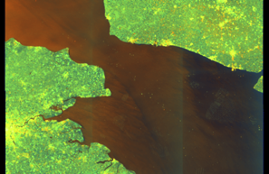
Satellite imagery available but requires review
Preview available for manual review
Show Raw Evidence JSON
{
    "vessel_a": {
        "mmsi": 269057738,
        "name": "CRATOS",
        "flag": "SWITZERLAND"
    },
    "vessel_b": {
        "mmsi": 632001149,
        "imo": 9387279,
        "name": "ETHERA",
        "flag": "GUINEA"
    },
    "min_distance_m": 131.80000000000001136868377216160297393798828125,
    "avg_distance_m": 136.69999999999998863131622783839702606201171875,
    "distance_consistency_m": 2.70000000000000017763568394002504646778106689453125,
    "duration_minutes": 374.80000000000001136868377216160297393798828125,
    "overlap_duration_s": 22488,
    "speed_a_avg": 0,
    "speed_a_std": 0,
    "speed_b_avg": 0,
    "speed_b_std": 0,
    "speed_summary": {
        "vessel_a": {
            "avg_sog": 0,
            "max_sog": 0
        },
        "vessel_b": {
            "avg_sog": 0,
            "max_sog": 0
        }
    },
    "time_window": {
        "start": "2026-06-04T05:09:27+00:00",
        "end": "2026-06-04T11:24:15+00:00"
    },
    "points_count": {
        "vessel_a": 22,
        "vessel_b": 22
    },
    "zone_id": "discovered_002",
    "zone_name": "Archipelago Sea Sanction Zone",
    "score": {
        "value": 90,
        "components": {
            "distance_tightness": {
                "score": 20,
                "max": 25,
                "detail": "Min distance 132m, avg 137m"
            },
            "duration": {
                "score": 25,
                "max": 25,
                "detail": "Duration 375 minutes"
            },
            "speed_stability": {
                "score": 20,
                "max": 20,
                "detail": "both nearly stationary; very stable speeds"
            },
            "distance_consistency": {
                "score": 15,
                "max": 15,
                "detail": "Distance variance \u00b13m"
            },
            "isolation": {
                "score": 5,
                "max": 10,
                "detail": "Isolation data not available"
            },
            "context": {
                "score": 5,
                "max": 5,
                "detail": "In monitored zone: Archipelago Sea Sanction Zone"
            }
        },
        "summary": "High-confidence STS candidate. Two tankers (CRATOS and ETHERA) maintained close proximity (min 132m, avg 137m) for 375 minutes. Both vessels were slow-moving (avg speeds 0.0 and 0.0 knots). The stable separation distance suggests deliberate parallel positioning typical of cargo transfer. Event occurred in Archipelago Sea Sanction Zone, a known STS activity area."
    },
    "sar": {
        "status": "inconclusive",
        "centroid": {
            "lat": 51.33952409999999844103513169102370738983154296875,
            "lon": 3.19526619999999983434690875583328306674957275390625
        },
        "time_window": {
            "start_ts": "2026-06-04T05:09:27+00:00",
            "end_ts": "2026-06-04T11:24:15+00:00"
        },
        "searched_at": "2026-06-04T13:45:01.806847+00:00",
        "scene_id": "S1D_IW_GRDH_1SDV_20260603T174037_20260603T174102_003075_00550A_5A2A_COG",
        "scene_datetime": "2026-06-03T17:40:37.292366Z",
        "platform": "sentinel-1d",
        "bbox": {
            "min_lon": -0.307396999999999975816677988404990173876285552978515625,
            "min_lat": 50.39084600000000335739969159476459026336669921875,
            "max_lon": 3.845746999999999804487060828250832855701446533203125,
            "max_lat": 52.29554699999999911597114987671375274658203125
        },
        "assets": {
            "preview_url": "https:\/\/fleetleaks.com\/wp-content\/uploads\/fleetleaks-evidence\/sar-imagery\/2026\/06\/event_671102_thumbnail_20260604134506.png",
            "stored_path": "\/home\/fleetleaks\/public_html\/wp-content\/uploads\/fleetleaks-evidence\/sar-imagery\/2026\/06\/event_671102_thumbnail_20260604134506.png",
            "source": "copernicus_dataspace"
        },
        "notes": "Preview available for manual review"
    }
}- Zone: Archipelago Sea Sanction Zone
- Duration: 6h 26m
- Data Points: 21 AIS positions
- Period: 2026-06-04T05:39:26+00:00 to 2026-06-04T12:06:16+00:00
Show Raw Evidence JSON
{
    "zone_id": "discovered_002",
    "zone_name": "Archipelago Sea Sanction Zone",
    "dwell_minutes": 386.80000000000001136868377216160297393798828125,
    "points_in_zone": 21,
    "first_point": {
        "ts": "2026-06-04T05:39:26+00:00",
        "lat": 51.3400917000000021062078303657472133636474609375,
        "lon": 3.194891699999999890025037529994733631610870361328125
    },
    "last_point": {
        "ts": "2026-06-04T12:06:16+00:00",
        "lat": 51.3400917000000021062078303657472133636474609375,
        "lon": 3.194891699999999890025037529994733631610870361328125
    }
}- Duration: 6h 26m
- Radius: 0 meters
- Data Points: 21 AIS positions
- Centroid: 51.3401, 3.1949
- Zone: Archipelago Sea Sanction Zone
Show Raw Evidence JSON
{
    "radius_m": 0,
    "duration_minutes": 386.80000000000001136868377216160297393798828125,
    "points": 21,
    "centroid": {
        "lat": 51.3400917000000021062078303657472133636474609375,
        "lon": 3.19489170000000033411424738005734980106353759765625
    },
    "bbox": {
        "min_lat": 51.3400917000000021062078303657472133636474609375,
        "min_lon": 3.194891699999999890025037529994733631610870361328125,
        "max_lat": 51.3400917000000021062078303657472133636474609375,
        "max_lon": 3.194891699999999890025037529994733631610870361328125
    },
    "zone_id": "discovered_002"
}- Minimum Distance: 132 meters
- Average Distance: 137 meters
- Duration: 6h 30m
- Period: 2026-06-04T04:54:14+00:00 to 2026-06-04T11:24:15+00:00
- Vessel A Avg Speed: 0.0 knots
- Vessel B Avg Speed: 0.0 knots
- Zone: Archipelago Sea Sanction Zone
Confidence Analysis
High-confidence STS candidate. Two tankers (CRATOS and ETHERA) maintained close proximity (min 132m, avg 137m) for 390 minutes. Both vessels were slow-moving (avg speeds 0.0 and 0.0 knots). The stable separation distance suggests deliberate parallel positioning typical of cargo transfer. Event occurred in Archipelago Sea Sanction Zone, a known STS activity area.
View scoring breakdown
| Factor | Score | Detail |
|---|---|---|
| Distance Tightness | 20/25 | Min distance 132m, avg 137m |
| Duration | 25/25 | Duration 390 minutes |
| Speed Stability | 20/20 | both nearly stationary; very stable speeds |
| Distance Consistency | 15/15 | Distance variance ±3m |
| Isolation | 5/10 | Isolation data not available |
| Context | 5/5 | In monitored zone: Archipelago Sea Sanction Zone |
🛰️ Satellite Corroboration
Satellite imagery available but requires review
Preview available for manual review

Show Raw Evidence JSON
{
    "vessel_a": {
        "mmsi": 269057738,
        "name": "CRATOS",
        "flag": "SWITZERLAND"
    },
    "vessel_b": {
        "mmsi": 632001149,
        "imo": 9387279,
        "name": "ETHERA",
        "flag": "GUINEA"
    },
    "min_distance_m": 131.80000000000001136868377216160297393798828125,
    "avg_distance_m": 136.80000000000001136868377216160297393798828125,
    "distance_consistency_m": 2.600000000000000088817841970012523233890533447265625,
    "duration_minutes": 390,
    "overlap_duration_s": 23401,
    "speed_a_avg": 0,
    "speed_a_std": 0,
    "speed_b_avg": 0,
    "speed_b_std": 0,
    "speed_summary": {
        "vessel_a": {
            "avg_sog": 0,
            "max_sog": 0
        },
        "vessel_b": {
            "avg_sog": 0,
            "max_sog": 0
        }
    },
    "time_window": {
        "start": "2026-06-04T04:54:14+00:00",
        "end": "2026-06-04T11:24:15+00:00"
    },
    "points_count": {
        "vessel_a": 24,
        "vessel_b": 24
    },
    "zone_id": "discovered_002",
    "zone_name": "Archipelago Sea Sanction Zone",
    "score": {
        "value": 90,
        "components": {
            "distance_tightness": {
                "score": 20,
                "max": 25,
                "detail": "Min distance 132m, avg 137m"
            },
            "duration": {
                "score": 25,
                "max": 25,
                "detail": "Duration 390 minutes"
            },
            "speed_stability": {
                "score": 20,
                "max": 20,
                "detail": "both nearly stationary; very stable speeds"
            },
            "distance_consistency": {
                "score": 15,
                "max": 15,
                "detail": "Distance variance \u00b13m"
            },
            "isolation": {
                "score": 5,
                "max": 10,
                "detail": "Isolation data not available"
            },
            "context": {
                "score": 5,
                "max": 5,
                "detail": "In monitored zone: Archipelago Sea Sanction Zone"
            }
        },
        "summary": "High-confidence STS candidate. Two tankers (CRATOS and ETHERA) maintained close proximity (min 132m, avg 137m) for 390 minutes. Both vessels were slow-moving (avg speeds 0.0 and 0.0 knots). The stable separation distance suggests deliberate parallel positioning typical of cargo transfer. Event occurred in Archipelago Sea Sanction Zone, a known STS activity area."
    },
    "sar": {
        "status": "inconclusive",
        "centroid": {
            "lat": 51.33953000000000344016370945610105991363525390625,
            "lon": 3.19526820000000011390284271328710019588470458984375
        },
        "time_window": {
            "start_ts": "2026-06-04T04:04:25+00:00",
            "end_ts": "2026-06-04T11:24:15+00:00"
        },
        "searched_at": "2026-06-04T13:00:18.518000+00:00",
        "scene_id": "S1D_IW_GRDH_1SDV_20260603T174037_20260603T174102_003075_00550A_5A2A_COG",
        "scene_datetime": "2026-06-03T17:40:37.292366Z",
        "platform": "sentinel-1d",
        "bbox": {
            "min_lon": -0.307396999999999975816677988404990173876285552978515625,
            "min_lat": 50.39084600000000335739969159476459026336669921875,
            "max_lon": 3.845746999999999804487060828250832855701446533203125,
            "max_lat": 52.29554699999999911597114987671375274658203125
        },
        "assets": {
            "preview_url": "https:\/\/fleetleaks.com\/wp-content\/uploads\/fleetleaks-evidence\/sar-imagery\/2026\/06\/event_670688_thumbnail_20260604130022.png",
            "stored_path": "\/home\/fleetleaks\/public_html\/wp-content\/uploads\/fleetleaks-evidence\/sar-imagery\/2026\/06\/event_670688_thumbnail_20260604130022.png",
            "source": "copernicus_dataspace"
        },
        "notes": "Preview available for manual review"
    }
}- Zone: Archipelago Sea Sanction Zone
- Duration: 6h 32m
- Data Points: 25 AIS positions
- Period: 2026-06-04T04:51:25+00:00 to 2026-06-04T11:24:15+00:00
Show Raw Evidence JSON
{
    "zone_id": "discovered_002",
    "zone_name": "Archipelago Sea Sanction Zone",
    "dwell_minutes": 392.80000000000001136868377216160297393798828125,
    "points_in_zone": 25,
    "first_point": {
        "ts": "2026-06-04T04:51:25+00:00",
        "lat": 51.3400917000000021062078303657472133636474609375,
        "lon": 3.194891699999999890025037529994733631610870361328125
    },
    "last_point": {
        "ts": "2026-06-04T11:24:15+00:00",
        "lat": 51.3400917000000021062078303657472133636474609375,
        "lon": 3.194891699999999890025037529994733631610870361328125
    }
}- Duration: 6h 32m
- Radius: 0 meters
- Data Points: 25 AIS positions
- Centroid: 51.3401, 3.1949
- Zone: Archipelago Sea Sanction Zone
Show Raw Evidence JSON
{
    "radius_m": 0,
    "duration_minutes": 392.80000000000001136868377216160297393798828125,
    "points": 25,
    "centroid": {
        "lat": 51.340091699999987895353115163743495941162109375,
        "lon": 3.194891699999999890025037529994733631610870361328125
    },
    "bbox": {
        "min_lat": 51.3400917000000021062078303657472133636474609375,
        "min_lon": 3.194891699999999890025037529994733631610870361328125,
        "max_lat": 51.3400917000000021062078303657472133636474609375,
        "max_lon": 3.194891699999999890025037529994733631610870361328125
    },
    "zone_id": "discovered_002"
}- Minimum Distance: 131 meters
- Average Distance: 137 meters
- Duration: 6h 24m
- Period: 2026-06-04T03:15:28+00:00 to 2026-06-04T09:39:26+00:00
- Vessel A Avg Speed: 0.0 knots
- Vessel B Avg Speed: 0.0 knots
- Zone: Archipelago Sea Sanction Zone
Confidence Analysis
High-confidence STS candidate. Two tankers (CRATOS and ETHERA) maintained close proximity (min 131m, avg 137m) for 384 minutes. Both vessels were slow-moving (avg speeds 0.0 and 0.0 knots). The stable separation distance suggests deliberate parallel positioning typical of cargo transfer. Event occurred in Archipelago Sea Sanction Zone, a known STS activity area.
View scoring breakdown
| Factor | Score | Detail |
|---|---|---|
| Distance Tightness | 20/25 | Min distance 131m, avg 137m |
| Duration | 25/25 | Duration 384 minutes |
| Speed Stability | 20/20 | both nearly stationary; very stable speeds |
| Distance Consistency | 15/15 | Distance variance ±3m |
| Isolation | 5/10 | Isolation data not available |
| Context | 5/5 | In monitored zone: Archipelago Sea Sanction Zone |
🛰️ Satellite Corroboration
Satellite imagery available but requires review
Preview available for manual review

Show Raw Evidence JSON
{
    "vessel_a": {
        "mmsi": 269057738,
        "name": "CRATOS",
        "flag": "SWITZERLAND"
    },
    "vessel_b": {
        "mmsi": 632001149,
        "imo": 9387279,
        "name": "ETHERA",
        "flag": "GUINEA"
    },
    "min_distance_m": 131.19999999999998863131622783839702606201171875,
    "avg_distance_m": 136.80000000000001136868377216160297393798828125,
    "distance_consistency_m": 3.29999999999999982236431605997495353221893310546875,
    "duration_minutes": 384,
    "overlap_duration_s": 23038,
    "speed_a_avg": 0,
    "speed_a_std": 0,
    "speed_b_avg": 0,
    "speed_b_std": 0,
    "speed_summary": {
        "vessel_a": {
            "avg_sog": 0,
            "max_sog": 0
        },
        "vessel_b": {
            "avg_sog": 0,
            "max_sog": 0
        }
    },
    "time_window": {
        "start": "2026-06-04T03:15:28+00:00",
        "end": "2026-06-04T09:39:26+00:00"
    },
    "points_count": {
        "vessel_a": 35,
        "vessel_b": 35
    },
    "zone_id": "discovered_002",
    "zone_name": "Archipelago Sea Sanction Zone",
    "score": {
        "value": 90,
        "components": {
            "distance_tightness": {
                "score": 20,
                "max": 25,
                "detail": "Min distance 131m, avg 137m"
            },
            "duration": {
                "score": 25,
                "max": 25,
                "detail": "Duration 384 minutes"
            },
            "speed_stability": {
                "score": 20,
                "max": 20,
                "detail": "both nearly stationary; very stable speeds"
            },
            "distance_consistency": {
                "score": 15,
                "max": 15,
                "detail": "Distance variance \u00b13m"
            },
            "isolation": {
                "score": 5,
                "max": 10,
                "detail": "Isolation data not available"
            },
            "context": {
                "score": 5,
                "max": 5,
                "detail": "In monitored zone: Archipelago Sea Sanction Zone"
            }
        },
        "summary": "High-confidence STS candidate. Two tankers (CRATOS and ETHERA) maintained close proximity (min 131m, avg 137m) for 384 minutes. Both vessels were slow-moving (avg speeds 0.0 and 0.0 knots). The stable separation distance suggests deliberate parallel positioning typical of cargo transfer. Event occurred in Archipelago Sea Sanction Zone, a known STS activity area."
    },
    "sar": {
        "status": "inconclusive",
        "centroid": {
            "lat": 51.33952330000000330301190842874348163604736328125,
            "lon": 3.1952695000000002067963578156195580959320068359375
        },
        "time_window": {
            "start_ts": "2026-06-04T03:03:24+00:00",
            "end_ts": "2026-06-04T09:39:26+00:00"
        },
        "searched_at": "2026-06-04T12:30:07.499904+00:00",
        "scene_id": "S1D_IW_GRDH_1SDV_20260603T174037_20260603T174102_003075_00550A_5A2A_COG",
        "scene_datetime": "2026-06-03T17:40:37.292366Z",
        "platform": "sentinel-1d",
        "bbox": {
            "min_lon": -0.307396999999999975816677988404990173876285552978515625,
            "min_lat": 50.39084600000000335739969159476459026336669921875,
            "max_lon": 3.845746999999999804487060828250832855701446533203125,
            "max_lat": 52.29554699999999911597114987671375274658203125
        },
        "assets": {
            "preview_url": "https:\/\/fleetleaks.com\/wp-content\/uploads\/fleetleaks-evidence\/sar-imagery\/2026\/06\/event_670385_thumbnail_20260604123010.png",
            "stored_path": "\/home\/fleetleaks\/public_html\/wp-content\/uploads\/fleetleaks-evidence\/sar-imagery\/2026\/06\/event_670385_thumbnail_20260604123010.png",
            "source": "copernicus_dataspace"
        },
        "notes": "Preview available for manual review"
    }
}- Zone: Archipelago Sea Sanction Zone
- Duration: 6h 36m
- Data Points: 38 AIS positions
- Period: 2026-06-04T03:03:24+00:00 to 2026-06-04T09:39:26+00:00
Show Raw Evidence JSON
{
    "zone_id": "discovered_002",
    "zone_name": "Archipelago Sea Sanction Zone",
    "dwell_minutes": 396,
    "points_in_zone": 38,
    "first_point": {
        "ts": "2026-06-04T03:03:24+00:00",
        "lat": 51.3400917000000021062078303657472133636474609375,
        "lon": 3.194891699999999890025037529994733631610870361328125
    },
    "last_point": {
        "ts": "2026-06-04T09:39:26+00:00",
        "lat": 51.3400917000000021062078303657472133636474609375,
        "lon": 3.194891699999999890025037529994733631610870361328125
    }
}- Duration: 6h 36m
- Radius: 0 meters
- Data Points: 38 AIS positions
- Centroid: 51.3401, 3.1949
- Zone: Archipelago Sea Sanction Zone
Show Raw Evidence JSON
{
    "radius_m": 0.1000000000000000055511151231257827021181583404541015625,
    "duration_minutes": 396,
    "points": 38,
    "centroid": {
        "lat": 51.34009169999995947364368475973606109619140625,
        "lon": 3.194891386842105163168525905348360538482666015625
    },
    "bbox": {
        "min_lat": 51.3400917000000021062078303657472133636474609375,
        "min_lon": 3.19489000000000000767386154620908200740814208984375,
        "max_lat": 51.3400917000000021062078303657472133636474609375,
        "max_lon": 3.194891699999999890025037529994733631610870361328125
    },
    "zone_id": "discovered_002"
}- Zone: Archipelago Sea Sanction Zone
- Duration: 6h 36m
- Data Points: 39 AIS positions
- Period: 2026-06-04T02:42:15+00:00 to 2026-06-04T09:18:18+00:00
Show Raw Evidence JSON
{
    "zone_id": "discovered_002",
    "zone_name": "Archipelago Sea Sanction Zone",
    "dwell_minutes": 396.1000000000000227373675443232059478759765625,
    "points_in_zone": 39,
    "first_point": {
        "ts": "2026-06-04T02:42:15+00:00",
        "lat": 51.3400917000000021062078303657472133636474609375,
        "lon": 3.194891699999999890025037529994733631610870361328125
    },
    "last_point": {
        "ts": "2026-06-04T09:18:18+00:00",
        "lat": 51.3400917000000021062078303657472133636474609375,
        "lon": 3.194891699999999890025037529994733631610870361328125
    }
}- Duration: 6h 36m
- Radius: 0 meters
- Data Points: 39 AIS positions
- Centroid: 51.3401, 3.1949
- Zone: Archipelago Sea Sanction Zone
Show Raw Evidence JSON
{
    "radius_m": 0.1000000000000000055511151231257827021181583404541015625,
    "duration_minutes": 396.1000000000000227373675443232059478759765625,
    "points": 39,
    "centroid": {
        "lat": 51.34009169999995236821632715873420238494873046875,
        "lon": 3.194891394871794521037600134150125086307525634765625
    },
    "bbox": {
        "min_lat": 51.3400917000000021062078303657472133636474609375,
        "min_lon": 3.19489000000000000767386154620908200740814208984375,
        "max_lat": 51.3400917000000021062078303657472133636474609375,
        "max_lon": 3.194891699999999890025037529994733631610870361328125
    },
    "zone_id": "discovered_002"
}- Minimum Distance: 130 meters
- Average Distance: 137 meters
- Duration: 6h 12m
- Period: 2026-06-04T02:39:25+00:00 to 2026-06-04T08:51:25+00:00
- Vessel A Avg Speed: 0.0 knots
- Vessel B Avg Speed: 0.0 knots
- Zone: Archipelago Sea Sanction Zone
Confidence Analysis
High-confidence STS candidate. Two tankers (CRATOS and ETHERA) maintained close proximity (min 130m, avg 137m) for 372 minutes. Both vessels were slow-moving (avg speeds 0.0 and 0.0 knots). The stable separation distance suggests deliberate parallel positioning typical of cargo transfer. Event occurred in Archipelago Sea Sanction Zone, a known STS activity area.
View scoring breakdown
| Factor | Score | Detail |
|---|---|---|
| Distance Tightness | 20/25 | Min distance 130m, avg 137m |
| Duration | 25/25 | Duration 372 minutes |
| Speed Stability | 20/20 | both nearly stationary; very stable speeds |
| Distance Consistency | 15/15 | Distance variance ±3m |
| Isolation | 5/10 | Isolation data not available |
| Context | 5/5 | In monitored zone: Archipelago Sea Sanction Zone |
🛰️ Satellite Corroboration
Satellite imagery available but requires review
Preview available for manual review

Show Raw Evidence JSON
{
    "vessel_a": {
        "mmsi": 269057738,
        "name": "CRATOS",
        "flag": "SWITZERLAND"
    },
    "vessel_b": {
        "mmsi": 632001149,
        "imo": 9387279,
        "name": "ETHERA",
        "flag": "GUINEA"
    },
    "min_distance_m": 130.400000000000005684341886080801486968994140625,
    "avg_distance_m": 136.900000000000005684341886080801486968994140625,
    "distance_consistency_m": 3.399999999999999911182158029987476766109466552734375,
    "duration_minutes": 372,
    "overlap_duration_s": 22320,
    "speed_a_avg": 0,
    "speed_a_std": 0,
    "speed_b_avg": 0,
    "speed_b_std": 0,
    "speed_summary": {
        "vessel_a": {
            "avg_sog": 0,
            "max_sog": 0
        },
        "vessel_b": {
            "avg_sog": 0,
            "max_sog": 0
        }
    },
    "time_window": {
        "start": "2026-06-04T02:39:25+00:00",
        "end": "2026-06-04T08:51:25+00:00"
    },
    "points_count": {
        "vessel_a": 39,
        "vessel_b": 39
    },
    "zone_id": "discovered_002",
    "zone_name": "Archipelago Sea Sanction Zone",
    "score": {
        "value": 90,
        "components": {
            "distance_tightness": {
                "score": 20,
                "max": 25,
                "detail": "Min distance 130m, avg 137m"
            },
            "duration": {
                "score": 25,
                "max": 25,
                "detail": "Duration 372 minutes"
            },
            "speed_stability": {
                "score": 20,
                "max": 20,
                "detail": "both nearly stationary; very stable speeds"
            },
            "distance_consistency": {
                "score": 15,
                "max": 15,
                "detail": "Distance variance \u00b13m"
            },
            "isolation": {
                "score": 5,
                "max": 10,
                "detail": "Isolation data not available"
            },
            "context": {
                "score": 5,
                "max": 5,
                "detail": "In monitored zone: Archipelago Sea Sanction Zone"
            }
        },
        "summary": "High-confidence STS candidate. Two tankers (CRATOS and ETHERA) maintained close proximity (min 130m, avg 137m) for 372 minutes. Both vessels were slow-moving (avg speeds 0.0 and 0.0 knots). The stable separation distance suggests deliberate parallel positioning typical of cargo transfer. Event occurred in Archipelago Sea Sanction Zone, a known STS activity area."
    },
    "sar": {
        "status": "inconclusive",
        "centroid": {
            "lat": 51.339523700000000872023520059883594512939453125,
            "lon": 3.19526969999999987948058333131484687328338623046875
        },
        "time_window": {
            "start_ts": "2026-06-04T02:10:22+00:00",
            "end_ts": "2026-06-04T08:51:25+00:00"
        },
        "searched_at": "2026-06-04T10:15:13.636158+00:00",
        "scene_id": "S1D_IW_GRDH_1SDV_20260603T174037_20260603T174102_003075_00550A_5A2A_COG",
        "scene_datetime": "2026-06-03T17:40:37.292366Z",
        "platform": "sentinel-1d",
        "bbox": {
            "min_lon": -0.307396999999999975816677988404990173876285552978515625,
            "min_lat": 50.39084600000000335739969159476459026336669921875,
            "max_lon": 3.845746999999999804487060828250832855701446533203125,
            "max_lat": 52.29554699999999911597114987671375274658203125
        },
        "assets": {
            "preview_url": "https:\/\/fleetleaks.com\/wp-content\/uploads\/fleetleaks-evidence\/sar-imagery\/2026\/06\/event_668930_thumbnail_20260604101518.png",
            "stored_path": "\/home\/fleetleaks\/public_html\/wp-content\/uploads\/fleetleaks-evidence\/sar-imagery\/2026\/06\/event_668930_thumbnail_20260604101518.png",
            "source": "copernicus_dataspace"
        },
        "notes": "Preview available for manual review"
    }
}- Minimum Distance: 131 meters
- Average Distance: 137 meters
- Duration: 6 hours
- Period: 2026-06-04T01:12:15+00:00 to 2026-06-04T07:12:16+00:00
- Vessel A Avg Speed: 0.0 knots
- Vessel B Avg Speed: 0.0 knots
- Zone: Archipelago Sea Sanction Zone
Confidence Analysis
High-confidence STS candidate. Two tankers (CRATOS and ETHERA) maintained close proximity (min 131m, avg 137m) for 360 minutes. Both vessels were slow-moving (avg speeds 0.0 and 0.0 knots). The stable separation distance suggests deliberate parallel positioning typical of cargo transfer. Event occurred in Archipelago Sea Sanction Zone, a known STS activity area.
View scoring breakdown
| Factor | Score | Detail |
|---|---|---|
| Distance Tightness | 20/25 | Min distance 131m, avg 137m |
| Duration | 25/25 | Duration 360 minutes |
| Speed Stability | 20/20 | both nearly stationary; very stable speeds |
| Distance Consistency | 15/15 | Distance variance ±3m |
| Isolation | 5/10 | Isolation data not available |
| Context | 5/5 | In monitored zone: Archipelago Sea Sanction Zone |
🛰️ Satellite Corroboration
Satellite imagery available but requires review
Preview available for manual review

Show Raw Evidence JSON
{
    "vessel_a": {
        "mmsi": 269057738,
        "name": "CRATOS",
        "flag": "SWITZERLAND"
    },
    "vessel_b": {
        "mmsi": 632001149,
        "imo": 9387279,
        "name": "ETHERA",
        "flag": "GUINEA"
    },
    "min_distance_m": 131.19999999999998863131622783839702606201171875,
    "avg_distance_m": 137.19999999999998863131622783839702606201171875,
    "distance_consistency_m": 3,
    "duration_minutes": 360,
    "overlap_duration_s": 21601,
    "speed_a_avg": 0,
    "speed_a_std": 0,
    "speed_b_avg": 0,
    "speed_b_std": 0,
    "speed_summary": {
        "vessel_a": {
            "avg_sog": 0,
            "max_sog": 0
        },
        "vessel_b": {
            "avg_sog": 0,
            "max_sog": 0
        }
    },
    "time_window": {
        "start": "2026-06-04T01:12:15+00:00",
        "end": "2026-06-04T07:12:16+00:00"
    },
    "points_count": {
        "vessel_a": 40,
        "vessel_b": 40
    },
    "zone_id": "discovered_002",
    "zone_name": "Archipelago Sea Sanction Zone",
    "score": {
        "value": 90,
        "components": {
            "distance_tightness": {
                "score": 20,
                "max": 25,
                "detail": "Min distance 131m, avg 137m"
            },
            "duration": {
                "score": 25,
                "max": 25,
                "detail": "Duration 360 minutes"
            },
            "speed_stability": {
                "score": 20,
                "max": 20,
                "detail": "both nearly stationary; very stable speeds"
            },
            "distance_consistency": {
                "score": 15,
                "max": 15,
                "detail": "Distance variance \u00b13m"
            },
            "isolation": {
                "score": 5,
                "max": 10,
                "detail": "Isolation data not available"
            },
            "context": {
                "score": 5,
                "max": 5,
                "detail": "In monitored zone: Archipelago Sea Sanction Zone"
            }
        },
        "summary": "High-confidence STS candidate. Two tankers (CRATOS and ETHERA) maintained close proximity (min 131m, avg 137m) for 360 minutes. Both vessels were slow-moving (avg speeds 0.0 and 0.0 knots). The stable separation distance suggests deliberate parallel positioning typical of cargo transfer. Event occurred in Archipelago Sea Sanction Zone, a known STS activity area."
    },
    "sar": {
        "status": "inconclusive",
        "centroid": {
            "lat": 51.3395234999999985348040354438126087188720703125,
            "lon": 3.1952701000000001130274540628306567668914794921875
        },
        "time_window": {
            "start_ts": "2026-06-04T01:12:15+00:00",
            "end_ts": "2026-06-04T07:12:16+00:00"
        },
        "searched_at": "2026-06-04T12:15:12.483978+00:00",
        "scene_id": "S1D_IW_GRDH_1SDV_20260603T174037_20260603T174102_003075_00550A_5A2A_COG",
        "scene_datetime": "2026-06-03T17:40:37.292366Z",
        "platform": "sentinel-1d",
        "bbox": {
            "min_lon": -0.307396999999999975816677988404990173876285552978515625,
            "min_lat": 50.39084600000000335739969159476459026336669921875,
            "max_lon": 3.845746999999999804487060828250832855701446533203125,
            "max_lat": 52.29554699999999911597114987671375274658203125
        },
        "assets": {
            "preview_url": "https:\/\/fleetleaks.com\/wp-content\/uploads\/fleetleaks-evidence\/sar-imagery\/2026\/06\/event_670060_thumbnail_20260604121516.png",
            "stored_path": "\/home\/fleetleaks\/public_html\/wp-content\/uploads\/fleetleaks-evidence\/sar-imagery\/2026\/06\/event_670060_thumbnail_20260604121516.png",
            "source": "copernicus_dataspace"
        },
        "notes": "Preview available for manual review"
    }
}- Zone: Archipelago Sea Sanction Zone
- Duration: 6h 33m
- Data Points: 42 AIS positions
- Period: 2026-06-04T01:24:16+00:00 to 2026-06-04T07:57:26+00:00
Show Raw Evidence JSON
{
    "zone_id": "discovered_002",
    "zone_name": "Archipelago Sea Sanction Zone",
    "dwell_minutes": 393.19999999999998863131622783839702606201171875,
    "points_in_zone": 42,
    "first_point": {
        "ts": "2026-06-04T01:24:16+00:00",
        "lat": 51.34011670000000293612174573354423046112060546875,
        "lon": 3.194911700000000021049118004157207906246185302734375
    },
    "last_point": {
        "ts": "2026-06-04T07:57:26+00:00",
        "lat": 51.3400917000000021062078303657472133636474609375,
        "lon": 3.194891699999999890025037529994733631610870361328125
    }
}- Duration: 6h 33m
- Radius: 3 meters
- Data Points: 42 AIS positions
- Centroid: 51.3401, 3.1949
- Zone: Archipelago Sea Sanction Zone
Show Raw Evidence JSON
{
    "radius_m": 3,
    "duration_minutes": 393.19999999999998863131622783839702606201171875,
    "points": 42,
    "centroid": {
        "lat": 51.3400922952380511787850991822779178619384765625,
        "lon": 3.194891852380952190770813103881664574146270751953125
    },
    "bbox": {
        "min_lat": 51.3400917000000021062078303657472133636474609375,
        "min_lon": 3.19489000000000000767386154620908200740814208984375,
        "max_lat": 51.34011670000000293612174573354423046112060546875,
        "max_lon": 3.194911700000000021049118004157207906246185302734375
    },
    "zone_id": "discovered_002"
}- Zone: Archipelago Sea Sanction Zone
- Duration: 6h 26m
- Data Points: 44 AIS positions
- Period: 2026-06-04T00:15:26+00:00 to 2026-06-04T06:42:14+00:00
Show Raw Evidence JSON
{
    "zone_id": "discovered_002",
    "zone_name": "Archipelago Sea Sanction Zone",
    "dwell_minutes": 386.80000000000001136868377216160297393798828125,
    "points_in_zone": 44,
    "first_point": {
        "ts": "2026-06-04T00:15:26+00:00",
        "lat": 51.34019669999999990750438882969319820404052734375,
        "lon": 3.194933300000000198082261704257689416408538818359375
    },
    "last_point": {
        "ts": "2026-06-04T06:42:14+00:00",
        "lat": 51.3400917000000021062078303657472133636474609375,
        "lon": 3.194891699999999890025037529994733631610870361328125
    }
}- Duration: 6h 26m
- Radius: 11 meters
- Data Points: 44 AIS positions
- Centroid: 51.3401, 3.1949
- Zone: Archipelago Sea Sanction Zone
Show Raw Evidence JSON
{
    "radius_m": 10.699999999999999289457264239899814128875732421875,
    "duration_minutes": 386.80000000000001136868377216160297393798828125,
    "points": 44,
    "centroid": {
        "lat": 51.34010302272722725547282607294619083404541015625,
        "lon": 3.194896345454545372177790341083891689777374267578125
    },
    "bbox": {
        "min_lat": 51.3400917000000021062078303657472133636474609375,
        "min_lon": 3.19489000000000000767386154620908200740814208984375,
        "max_lat": 51.34019669999999990750438882969319820404052734375,
        "max_lon": 3.194933300000000198082261704257689416408538818359375
    },
    "zone_id": "discovered_002"
}- Minimum Distance: 131 meters
- Average Distance: 138 meters
- Duration: 6h 8m
- Period: 2026-06-04T00:33:27+00:00 to 2026-06-04T06:42:14+00:00
- Vessel A Avg Speed: 0.0 knots
- Vessel B Avg Speed: 0.0 knots
- Zone: Archipelago Sea Sanction Zone
Confidence Analysis
High-confidence STS candidate. Two tankers (CRATOS and ETHERA) maintained close proximity (min 131m, avg 138m) for 369 minutes. Both vessels were slow-moving (avg speeds 0.0 and 0.0 knots). The stable separation distance suggests deliberate parallel positioning typical of cargo transfer. Event occurred in Archipelago Sea Sanction Zone, a known STS activity area.
View scoring breakdown
| Factor | Score | Detail |
|---|---|---|
| Distance Tightness | 20/25 | Min distance 131m, avg 138m |
| Duration | 25/25 | Duration 369 minutes |
| Speed Stability | 20/20 | both nearly stationary; very stable speeds |
| Distance Consistency | 15/15 | Distance variance ±3m |
| Isolation | 5/10 | Isolation data not available |
| Context | 5/5 | In monitored zone: Archipelago Sea Sanction Zone |
🛰️ Satellite Corroboration
Satellite imagery available but requires review
Preview available for manual review

Show Raw Evidence JSON
{
    "vessel_a": {
        "mmsi": 269057738,
        "name": "CRATOS",
        "flag": "SWITZERLAND"
    },
    "vessel_b": {
        "mmsi": 632001149,
        "imo": 9387279,
        "name": "ETHERA",
        "flag": "GUINEA"
    },
    "min_distance_m": 131.19999999999998863131622783839702606201171875,
    "avg_distance_m": 137.5,
    "distance_consistency_m": 3.100000000000000088817841970012523233890533447265625,
    "duration_minutes": 368.80000000000001136868377216160297393798828125,
    "overlap_duration_s": 22127,
    "speed_a_avg": 0,
    "speed_a_std": 0,
    "speed_b_avg": 0,
    "speed_b_std": 0,
    "speed_summary": {
        "vessel_a": {
            "avg_sog": 0,
            "max_sog": 0
        },
        "vessel_b": {
            "avg_sog": 0,
            "max_sog": 0
        }
    },
    "time_window": {
        "start": "2026-06-04T00:33:27+00:00",
        "end": "2026-06-04T06:42:14+00:00"
    },
    "points_count": {
        "vessel_a": 42,
        "vessel_b": 42
    },
    "zone_id": "discovered_002",
    "zone_name": "Archipelago Sea Sanction Zone",
    "score": {
        "value": 90,
        "components": {
            "distance_tightness": {
                "score": 20,
                "max": 25,
                "detail": "Min distance 131m, avg 138m"
            },
            "duration": {
                "score": 25,
                "max": 25,
                "detail": "Duration 369 minutes"
            },
            "speed_stability": {
                "score": 20,
                "max": 20,
                "detail": "both nearly stationary; very stable speeds"
            },
            "distance_consistency": {
                "score": 15,
                "max": 15,
                "detail": "Distance variance \u00b13m"
            },
            "isolation": {
                "score": 5,
                "max": 10,
                "detail": "Isolation data not available"
            },
            "context": {
                "score": 5,
                "max": 5,
                "detail": "In monitored zone: Archipelago Sea Sanction Zone"
            }
        },
        "summary": "High-confidence STS candidate. Two tankers (CRATOS and ETHERA) maintained close proximity (min 131m, avg 138m) for 369 minutes. Both vessels were slow-moving (avg speeds 0.0 and 0.0 knots). The stable separation distance suggests deliberate parallel positioning typical of cargo transfer. Event occurred in Archipelago Sea Sanction Zone, a known STS activity area."
    },
    "sar": {
        "status": "inconclusive",
        "centroid": {
            "lat": 51.3395895999999964942617225460708141326904296875,
            "lon": 3.195272099999999948494178170221857726573944091796875
        },
        "time_window": {
            "start_ts": "2026-06-04T00:07:23+00:00",
            "end_ts": "2026-06-04T06:42:14+00:00"
        },
        "searched_at": "2026-06-04T09:30:10.176958+00:00",
        "scene_id": "S1D_IW_GRDH_1SDV_20260603T174037_20260603T174102_003075_00550A_5A2A_COG",
        "scene_datetime": "2026-06-03T17:40:37.292366Z",
        "platform": "sentinel-1d",
        "bbox": {
            "min_lon": -0.307396999999999975816677988404990173876285552978515625,
            "min_lat": 50.39084600000000335739969159476459026336669921875,
            "max_lon": 3.845746999999999804487060828250832855701446533203125,
            "max_lat": 52.29554699999999911597114987671375274658203125
        },
        "assets": {
            "preview_url": "https:\/\/fleetleaks.com\/wp-content\/uploads\/fleetleaks-evidence\/sar-imagery\/2026\/06\/event_668347_thumbnail_20260604093014.png",
            "stored_path": "\/home\/fleetleaks\/public_html\/wp-content\/uploads\/fleetleaks-evidence\/sar-imagery\/2026\/06\/event_668347_thumbnail_20260604093014.png",
            "source": "copernicus_dataspace"
        },
        "notes": "Preview available for manual review"
    }
}- Zone: Archipelago Sea Sanction Zone
- Duration: 6h 32m
- Data Points: 21 AIS positions
- Period: 2026-06-03T20:45:28+00:00 to 2026-06-04T03:18:16+00:00
Show Raw Evidence JSON
{
    "zone_id": "discovered_002",
    "zone_name": "Archipelago Sea Sanction Zone",
    "dwell_minutes": 392.80000000000001136868377216160297393798828125,
    "points_in_zone": 21,
    "first_point": {
        "ts": "2026-06-03T20:45:28+00:00",
        "lat": 51.34019669999999990750438882969319820404052734375,
        "lon": 3.194933300000000198082261704257689416408538818359375
    },
    "last_point": {
        "ts": "2026-06-04T03:18:16+00:00",
        "lat": 51.3400917000000021062078303657472133636474609375,
        "lon": 3.19489000000000000767386154620908200740814208984375
    }
}- Duration: 6h 32m
- Radius: 9 meters
- Data Points: 21 AIS positions
- Centroid: 51.3401, 3.1949
- Zone: Archipelago Sea Sanction Zone
Show Raw Evidence JSON
{
    "radius_m": 8.699999999999999289457264239899814128875732421875,
    "duration_minutes": 392.80000000000001136868377216160297393798828125,
    "points": 21,
    "centroid": {
        "lat": 51.34012042380951612585704424418509006500244140625,
        "lon": 3.1949038190476191090283464291132986545562744140625
    },
    "bbox": {
        "min_lat": 51.3400917000000021062078303657472133636474609375,
        "min_lon": 3.19489000000000000767386154620908200740814208984375,
        "max_lat": 51.34019669999999990750438882969319820404052734375,
        "max_lon": 3.194933300000000198082261704257689416408538818359375
    },
    "zone_id": "discovered_002"
}- Zone: Archipelago Sea Sanction Zone
- Duration: 4h 21m
- Data Points: 5 AIS positions
- Period: 2026-06-03T16:24:17+00:00 to 2026-06-03T20:45:28+00:00
Show Raw Evidence JSON
{
    "zone_id": "discovered_002",
    "zone_name": "Archipelago Sea Sanction Zone",
    "dwell_minutes": 261.19999999999998863131622783839702606201171875,
    "points_in_zone": 5,
    "first_point": {
        "ts": "2026-06-03T16:24:17+00:00",
        "lat": 51.3402200000000021873347577638924121856689453125,
        "lon": 3.1949532999999998850171323283575475215911865234375
    },
    "last_point": {
        "ts": "2026-06-03T20:45:28+00:00",
        "lat": 51.34019669999999990750438882969319820404052734375,
        "lon": 3.194933300000000198082261704257689416408538818359375
    }
}- Minimum Distance: 146 meters
- Average Distance: 147 meters
- Duration: 1h 44m
- Period: 2026-06-03T15:09:27+00:00 to 2026-06-03T16:54:15+00:00
- Vessel A Avg Speed: 0.0 knots
- Vessel B Avg Speed: 0.0 knots
- Zone: Archipelago Sea Sanction Zone
Confidence Analysis
High-confidence STS candidate. Two tankers (CRATOS and ETHERA) maintained close proximity (min 146m, avg 147m) for 105 minutes. Both vessels were slow-moving (avg speeds 0.0 and 0.0 knots). The stable separation distance suggests deliberate parallel positioning typical of cargo transfer. Event occurred in Archipelago Sea Sanction Zone, a known STS activity area.
View scoring breakdown
| Factor | Score | Detail |
|---|---|---|
| Distance Tightness | 20/25 | Min distance 146m, avg 147m |
| Duration | 20/25 | Duration 105 minutes |
| Speed Stability | 20/20 | both nearly stationary; very stable speeds |
| Distance Consistency | 15/15 | Distance variance ±2m |
| Isolation | 5/10 | Isolation data not available |
| Context | 5/5 | In monitored zone: Archipelago Sea Sanction Zone |
🛰️ Satellite Corroboration
Satellite imagery available but requires review
Preview available for manual review

Show Raw Evidence JSON
{
    "vessel_a": {
        "mmsi": 269057738,
        "name": "CRATOS",
        "flag": "SWITZERLAND"
    },
    "vessel_b": {
        "mmsi": 632001149,
        "imo": 9387279,
        "name": "ETHERA",
        "flag": "GUINEA"
    },
    "min_distance_m": 145.5,
    "avg_distance_m": 147,
    "distance_consistency_m": 1.600000000000000088817841970012523233890533447265625,
    "duration_minutes": 104.7999999999999971578290569595992565155029296875,
    "overlap_duration_s": 6288,
    "speed_a_avg": 0,
    "speed_a_std": 0,
    "speed_b_avg": 0,
    "speed_b_std": 0,
    "speed_summary": {
        "vessel_a": {
            "avg_sog": 0,
            "max_sog": 0
        },
        "vessel_b": {
            "avg_sog": 0,
            "max_sog": 0
        }
    },
    "time_window": {
        "start": "2026-06-03T15:09:27+00:00",
        "end": "2026-06-03T16:54:15+00:00"
    },
    "points_count": {
        "vessel_a": 6,
        "vessel_b": 6
    },
    "zone_id": "discovered_002",
    "zone_name": "Archipelago Sea Sanction Zone",
    "score": {
        "value": 85,
        "components": {
            "distance_tightness": {
                "score": 20,
                "max": 25,
                "detail": "Min distance 146m, avg 147m"
            },
            "duration": {
                "score": 20,
                "max": 25,
                "detail": "Duration 105 minutes"
            },
            "speed_stability": {
                "score": 20,
                "max": 20,
                "detail": "both nearly stationary; very stable speeds"
            },
            "distance_consistency": {
                "score": 15,
                "max": 15,
                "detail": "Distance variance \u00b12m"
            },
            "isolation": {
                "score": 5,
                "max": 10,
                "detail": "Isolation data not available"
            },
            "context": {
                "score": 5,
                "max": 5,
                "detail": "In monitored zone: Archipelago Sea Sanction Zone"
            }
        },
        "summary": "High-confidence STS candidate. Two tankers (CRATOS and ETHERA) maintained close proximity (min 146m, avg 147m) for 105 minutes. Both vessels were slow-moving (avg speeds 0.0 and 0.0 knots). The stable separation distance suggests deliberate parallel positioning typical of cargo transfer. Event occurred in Archipelago Sea Sanction Zone, a known STS activity area."
    },
    "sar": {
        "status": "inconclusive",
        "centroid": {
            "lat": 51.33959440000000284953785012476146221160888671875,
            "lon": 3.19529279999999982209146764944307506084442138671875
        },
        "time_window": {
            "start_ts": "2026-06-03T15:09:27+00:00",
            "end_ts": "2026-06-03T16:54:15+00:00"
        },
        "searched_at": "2026-06-04T06:30:01.997530+00:00",
        "scene_id": "S1D_IW_GRDH_1SDV_20260603T174037_20260603T174102_003075_00550A_5A2A_COG",
        "scene_datetime": "2026-06-03T17:40:37.292366Z",
        "platform": "sentinel-1d",
        "bbox": {
            "min_lon": -0.307396999999999975816677988404990173876285552978515625,
            "min_lat": 50.39084600000000335739969159476459026336669921875,
            "max_lon": 3.845746999999999804487060828250832855701446533203125,
            "max_lat": 52.29554699999999911597114987671375274658203125
        },
        "assets": {
            "preview_url": "https:\/\/fleetleaks.com\/wp-content\/uploads\/fleetleaks-evidence\/sar-imagery\/2026\/06\/event_666571_thumbnail_20260604063007.png",
            "stored_path": "\/home\/fleetleaks\/public_html\/wp-content\/uploads\/fleetleaks-evidence\/sar-imagery\/2026\/06\/event_666571_thumbnail_20260604063007.png",
            "source": "copernicus_dataspace"
        },
        "notes": "Preview available for manual review"
    }
}- Zone: Archipelago Sea Sanction Zone
- Duration: 5h 36m
- Data Points: 9 AIS positions
- Period: 2026-06-03T15:09:27+00:00 to 2026-06-03T20:45:28+00:00
Show Raw Evidence JSON
{
    "zone_id": "discovered_002",
    "zone_name": "Archipelago Sea Sanction Zone",
    "dwell_minutes": 336,
    "points_in_zone": 9,
    "first_point": {
        "ts": "2026-06-03T15:09:27+00:00",
        "lat": 51.3402200000000021873347577638924121856689453125,
        "lon": 3.1949532999999998850171323283575475215911865234375
    },
    "last_point": {
        "ts": "2026-06-03T20:45:28+00:00",
        "lat": 51.34019669999999990750438882969319820404052734375,
        "lon": 3.194933300000000198082261704257689416408538818359375
    }
}- Minimum Distance: 146 meters
- Average Distance: 150 meters
- Duration: 4h 23m
- Period: 2026-06-03T12:30:33+00:00 to 2026-06-03T16:54:15+00:00
- Vessel A Avg Speed: 0.0 knots
- Vessel B Avg Speed: 0.0 knots
- Zone: Archipelago Sea Sanction Zone
Confidence Analysis
High-confidence STS candidate. Two tankers (CRATOS and ETHERA) maintained close proximity (min 146m, avg 150m) for 264 minutes. Both vessels were slow-moving (avg speeds 0.0 and 0.0 knots). The stable separation distance suggests deliberate parallel positioning typical of cargo transfer. Event occurred in Archipelago Sea Sanction Zone, a known STS activity area.
View scoring breakdown
| Factor | Score | Detail |
|---|---|---|
| Distance Tightness | 20/25 | Min distance 146m, avg 150m |
| Duration | 25/25 | Duration 264 minutes |
| Speed Stability | 20/20 | both nearly stationary; very stable speeds |
| Distance Consistency | 15/15 | Distance variance ±4m |
| Isolation | 5/10 | Isolation data not available |
| Context | 5/5 | In monitored zone: Archipelago Sea Sanction Zone |
🛰️ Satellite Corroboration
Satellite imagery available but requires review
Preview available for manual review

Show Raw Evidence JSON
{
    "vessel_a": {
        "mmsi": 269057738,
        "name": "CRATOS",
        "flag": "SWITZERLAND"
    },
    "vessel_b": {
        "mmsi": 632001149,
        "imo": 9387279,
        "name": "ETHERA",
        "flag": "GUINEA"
    },
    "min_distance_m": 145.5,
    "avg_distance_m": 150.099999999999994315658113919198513031005859375,
    "distance_consistency_m": 3.79999999999999982236431605997495353221893310546875,
    "duration_minutes": 263.69999999999998863131622783839702606201171875,
    "overlap_duration_s": 15822,
    "speed_a_avg": 0,
    "speed_a_std": 0,
    "speed_b_avg": 0,
    "speed_b_std": 0,
    "speed_summary": {
        "vessel_a": {
            "avg_sog": 0,
            "max_sog": 0
        },
        "vessel_b": {
            "avg_sog": 0,
            "max_sog": 0
        }
    },
    "time_window": {
        "start": "2026-06-03T12:30:33+00:00",
        "end": "2026-06-03T16:54:15+00:00"
    },
    "points_count": {
        "vessel_a": 12,
        "vessel_b": 12
    },
    "zone_id": "discovered_002",
    "zone_name": "Archipelago Sea Sanction Zone",
    "score": {
        "value": 90,
        "components": {
            "distance_tightness": {
                "score": 20,
                "max": 25,
                "detail": "Min distance 146m, avg 150m"
            },
            "duration": {
                "score": 25,
                "max": 25,
                "detail": "Duration 264 minutes"
            },
            "speed_stability": {
                "score": 20,
                "max": 20,
                "detail": "both nearly stationary; very stable speeds"
            },
            "distance_consistency": {
                "score": 15,
                "max": 15,
                "detail": "Distance variance \u00b14m"
            },
            "isolation": {
                "score": 5,
                "max": 10,
                "detail": "Isolation data not available"
            },
            "context": {
                "score": 5,
                "max": 5,
                "detail": "In monitored zone: Archipelago Sea Sanction Zone"
            }
        },
        "summary": "High-confidence STS candidate. Two tankers (CRATOS and ETHERA) maintained close proximity (min 146m, avg 150m) for 264 minutes. Both vessels were slow-moving (avg speeds 0.0 and 0.0 knots). The stable separation distance suggests deliberate parallel positioning typical of cargo transfer. Event occurred in Archipelago Sea Sanction Zone, a known STS activity area."
    },
    "sar": {
        "status": "inconclusive",
        "centroid": {
            "lat": 51.3396120999999965306415106169879436492919921875,
            "lon": 3.19530419999999981683913574670441448688507080078125
        },
        "time_window": {
            "start_ts": "2026-06-03T12:30:33+00:00",
            "end_ts": "2026-06-03T16:54:15+00:00"
        },
        "searched_at": "2026-06-04T05:00:13.580968+00:00",
        "scene_id": "S1D_IW_GRDH_1SDV_20260603T174037_20260603T174102_003075_00550A_5A2A_COG",
        "scene_datetime": "2026-06-03T17:40:37.292366Z",
        "platform": "sentinel-1d",
        "bbox": {
            "min_lon": -0.307396999999999975816677988404990173876285552978515625,
            "min_lat": 50.39084600000000335739969159476459026336669921875,
            "max_lon": 3.845746999999999804487060828250832855701446533203125,
            "max_lat": 52.29554699999999911597114987671375274658203125
        },
        "assets": {
            "preview_url": "https:\/\/fleetleaks.com\/wp-content\/uploads\/fleetleaks-evidence\/sar-imagery\/2026\/06\/event_666219_thumbnail_20260604050017.png",
            "stored_path": "\/home\/fleetleaks\/public_html\/wp-content\/uploads\/fleetleaks-evidence\/sar-imagery\/2026\/06\/event_666219_thumbnail_20260604050017.png",
            "source": "copernicus_dataspace"
        },
        "notes": "Preview available for manual review"
    }
}- Zone: Archipelago Sea Sanction Zone
- Duration: 4h 52m
- Data Points: 22 AIS positions
- Period: 2026-06-03T12:01:48+00:00 to 2026-06-03T16:54:15+00:00
Show Raw Evidence JSON
{
    "zone_id": "discovered_002",
    "zone_name": "Archipelago Sea Sanction Zone",
    "dwell_minutes": 292.3999999999999772626324556767940521240234375,
    "points_in_zone": 22,
    "first_point": {
        "ts": "2026-06-03T12:01:48+00:00",
        "lat": 51.34098329999999776873664814047515392303466796875,
        "lon": 3.19197329999999990235437508090399205684661865234375
    },
    "last_point": {
        "ts": "2026-06-03T16:54:15+00:00",
        "lat": 51.3402200000000021873347577638924121856689453125,
        "lon": 3.1949532999999998850171323283575475215911865234375
    }
}- Duration: 4h 52m
- Radius: 133 meters
- Data Points: 22 AIS positions
- Centroid: 51.3406, 3.1938
- Zone: Archipelago Sea Sanction Zone
Show Raw Evidence JSON
{
    "radius_m": 133,
    "duration_minutes": 292.3999999999999772626324556767940521240234375,
    "points": 22,
    "centroid": {
        "lat": 51.3405646090909186796125140972435474395751953125,
        "lon": 3.1937611227272721947656464180909097194671630859375
    },
    "bbox": {
        "min_lat": 51.3402200000000021873347577638924121856689453125,
        "min_lon": 3.19197329999999990235437508090399205684661865234375,
        "max_lat": 51.34101170000000280424501397646963596343994140625,
        "max_lon": 3.1949766999999997807435647700913250446319580078125
    },
    "zone_id": "discovered_002"
}- Zone: Archipelago Sea Sanction Zone
- Duration: 5 hours
- Data Points: 25 AIS positions
- Period: 2026-06-03T11:54:08+00:00 to 2026-06-03T16:54:15+00:00
Show Raw Evidence JSON
{
    "zone_id": "discovered_002",
    "zone_name": "Archipelago Sea Sanction Zone",
    "dwell_minutes": 300.1000000000000227373675443232059478759765625,
    "points_in_zone": 25,
    "first_point": {
        "ts": "2026-06-03T11:54:08+00:00",
        "lat": 51.34081330000000065183485276065766811370849609375,
        "lon": 3.19405170000000016017338566598482429981231689453125
    },
    "last_point": {
        "ts": "2026-06-03T16:54:15+00:00",
        "lat": 51.3402200000000021873347577638924121856689453125,
        "lon": 3.1949532999999998850171323283575475215911865234375
    }
}- Duration: 5 hours
- Radius: 125 meters
- Data Points: 25 AIS positions
- Centroid: 51.3406, 3.1937
- Zone: Archipelago Sea Sanction Zone
Show Raw Evidence JSON
{
    "radius_m": 124.5,
    "duration_minutes": 300.1000000000000227373675443232059478759765625,
    "points": 25,
    "centroid": {
        "lat": 51.34062398800000437404378317296504974365234375,
        "lon": 3.1936650559999986143111527781002223491668701171875
    },
    "bbox": {
        "min_lat": 51.3402200000000021873347577638924121856689453125,
        "min_lon": 3.19197329999999990235437508090399205684661865234375,
        "max_lat": 51.34130329999999986512193572707474231719970703125,
        "max_lon": 3.1949766999999997807435647700913250446319580078125
    },
    "zone_id": "discovered_002"
}- Minimum Distance: 136 meters
- Average Distance: 311 meters
- Duration: 45 minutes
- Period: 2026-06-03T04:23:14+00:00 to 2026-06-03T05:08:16+00:00
- Vessel A Avg Speed: 0.2 knots
- Vessel B Avg Speed: 0.0 knots
- Zone: Archipelago Sea Sanction Zone
Confidence Analysis
Moderate-confidence STS candidate. Two tankers (CRATOS and ETHERA) maintained close proximity (min 136m, avg 311m) for 45 minutes. Both vessels were slow-moving (avg speeds 0.2 and 0.0 knots). Moderate distance variation observed during the encounter. Event occurred in Archipelago Sea Sanction Zone, a known STS activity area.
View scoring breakdown
| Factor | Score | Detail |
|---|---|---|
| Distance Tightness | 20/25 | Min distance 136m, avg 311m |
| Duration | 10/25 | Duration 45 minutes |
| Speed Stability | 17/20 | both nearly stationary; stable speeds |
| Distance Consistency | 8/15 | Distance variance ±62m |
| Isolation | 5/10 | Isolation data not available |
| Context | 5/5 | In monitored zone: Archipelago Sea Sanction Zone |
Show Raw Evidence JSON
{
    "vessel_a": {
        "mmsi": 269057738,
        "name": "CRATOS",
        "flag": "SWITZERLAND"
    },
    "vessel_b": {
        "mmsi": 632001149,
        "imo": 9387279,
        "name": "ETHERA",
        "flag": "GUINEA"
    },
    "min_distance_m": 136.400000000000005684341886080801486968994140625,
    "avg_distance_m": 311.19999999999998863131622783839702606201171875,
    "distance_consistency_m": 62.10000000000000142108547152020037174224853515625,
    "duration_minutes": 45,
    "overlap_duration_s": 2702,
    "speed_a_avg": 0.1700000000000000122124532708767219446599483489990234375,
    "speed_a_std": 0.36999999999999999555910790149937383830547332763671875,
    "speed_b_avg": 0,
    "speed_b_std": 0,
    "speed_summary": {
        "vessel_a": {
            "avg_sog": 0.1700000000000000122124532708767219446599483489990234375,
            "max_sog": 1.1999999999999999555910790149937383830547332763671875
        },
        "vessel_b": {
            "avg_sog": 0,
            "max_sog": 0
        }
    },
    "time_window": {
        "start": "2026-06-03T04:23:14+00:00",
        "end": "2026-06-03T05:08:16+00:00"
    },
    "points_count": {
        "vessel_a": 13,
        "vessel_b": 13
    },
    "zone_id": "discovered_002",
    "zone_name": "Archipelago Sea Sanction Zone",
    "score": {
        "value": 65,
        "components": {
            "distance_tightness": {
                "score": 20,
                "max": 25,
                "detail": "Min distance 136m, avg 311m"
            },
            "duration": {
                "score": 10,
                "max": 25,
                "detail": "Duration 45 minutes"
            },
            "speed_stability": {
                "score": 17,
                "max": 20,
                "detail": "both nearly stationary; stable speeds"
            },
            "distance_consistency": {
                "score": 8,
                "max": 15,
                "detail": "Distance variance \u00b162m"
            },
            "isolation": {
                "score": 5,
                "max": 10,
                "detail": "Isolation data not available"
            },
            "context": {
                "score": 5,
                "max": 5,
                "detail": "In monitored zone: Archipelago Sea Sanction Zone"
            }
        },
        "summary": "Moderate-confidence STS candidate. Two tankers (CRATOS and ETHERA) maintained close proximity (min 136m, avg 311m) for 45 minutes. Both vessels were slow-moving (avg speeds 0.2 and 0.0 knots). Moderate distance variation observed during the encounter. Event occurred in Archipelago Sea Sanction Zone, a known STS activity area."
    }
}- Minimum Distance: 131 meters
- Average Distance: 268 meters
- Duration: 1h 41m
- Period: 2026-06-03T03:26:45+00:00 to 2026-06-03T05:08:16+00:00
- Vessel A Avg Speed: 0.3 knots
- Vessel B Avg Speed: 0.0 knots
- Zone: Archipelago Sea Sanction Zone
Confidence Analysis
Moderate-confidence STS candidate. Two tankers (CRATOS and ETHERA) maintained close proximity (min 130m, avg 268m) for 102 minutes. Both vessels were slow-moving (avg speeds 0.3 and 0.0 knots). Moderate distance variation observed during the encounter. Event occurred in Archipelago Sea Sanction Zone, a known STS activity area.
View scoring breakdown
| Factor | Score | Detail |
|---|---|---|
| Distance Tightness | 20/25 | Min distance 130m, avg 268m |
| Duration | 20/25 | Duration 102 minutes |
| Speed Stability | 14/20 | both nearly stationary; somewhat variable speeds |
| Distance Consistency | 8/15 | Distance variance ±90m |
| Isolation | 5/10 | Isolation data not available |
| Context | 5/5 | In monitored zone: Archipelago Sea Sanction Zone |
🛰️ Satellite Corroboration
Satellite imagery available but requires review
Preview available for manual review
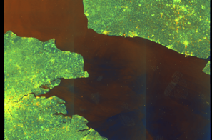
Show Raw Evidence JSON
{
    "vessel_a": {
        "mmsi": 269057738,
        "name": "CRATOS",
        "flag": "SWITZERLAND"
    },
    "vessel_b": {
        "mmsi": 632001149,
        "imo": 9387279,
        "name": "ETHERA",
        "flag": "GUINEA"
    },
    "min_distance_m": 130.5,
    "avg_distance_m": 268.3999999999999772626324556767940521240234375,
    "distance_consistency_m": 89.5,
    "duration_minutes": 101.5,
    "overlap_duration_s": 6091,
    "speed_a_avg": 0.2600000000000000088817841970012523233890533447265625,
    "speed_a_std": 0.5300000000000000266453525910037569701671600341796875,
    "speed_b_avg": 0,
    "speed_b_std": 0,
    "speed_summary": {
        "vessel_a": {
            "avg_sog": 0.2600000000000000088817841970012523233890533447265625,
            "max_sog": 1.899999999999999911182158029987476766109466552734375
        },
        "vessel_b": {
            "avg_sog": 0,
            "max_sog": 0
        }
    },
    "time_window": {
        "start": "2026-06-03T03:26:45+00:00",
        "end": "2026-06-03T05:08:16+00:00"
    },
    "points_count": {
        "vessel_a": 19,
        "vessel_b": 19
    },
    "zone_id": "discovered_002",
    "zone_name": "Archipelago Sea Sanction Zone",
    "score": {
        "value": 72,
        "components": {
            "distance_tightness": {
                "score": 20,
                "max": 25,
                "detail": "Min distance 130m, avg 268m"
            },
            "duration": {
                "score": 20,
                "max": 25,
                "detail": "Duration 102 minutes"
            },
            "speed_stability": {
                "score": 14,
                "max": 20,
                "detail": "both nearly stationary; somewhat variable speeds"
            },
            "distance_consistency": {
                "score": 8,
                "max": 15,
                "detail": "Distance variance \u00b190m"
            },
            "isolation": {
                "score": 5,
                "max": 10,
                "detail": "Isolation data not available"
            },
            "context": {
                "score": 5,
                "max": 5,
                "detail": "In monitored zone: Archipelago Sea Sanction Zone"
            }
        },
        "summary": "Moderate-confidence STS candidate. Two tankers (CRATOS and ETHERA) maintained close proximity (min 130m, avg 268m) for 102 minutes. Both vessels were slow-moving (avg speeds 0.3 and 0.0 knots). Moderate distance variation observed during the encounter. Event occurred in Archipelago Sea Sanction Zone, a known STS activity area."
    },
    "sar": {
        "status": "inconclusive",
        "centroid": {
            "lat": 51.33993770000000012032614904455840587615966796875,
            "lon": 3.194539400000000028967406251467764377593994140625
        },
        "time_window": {
            "start_ts": "2026-06-03T03:26:45+00:00",
            "end_ts": "2026-06-03T05:08:16+00:00"
        },
        "searched_at": "2026-06-03T10:00:13.409797+00:00",
        "scene_id": "S1C_IW_GRDH_1SDV_20260602T174027_20260602T174052_007930_0101FB_E62C_COG",
        "scene_datetime": "2026-06-02T17:40:27.270970Z",
        "platform": "sentinel-1c",
        "bbox": {
            "min_lon": -0.30640400000000000968469748841016553342342376708984375,
            "min_lat": 50.39082700000000158979673869907855987548828125,
            "max_lon": 3.792171000000000180563120011356659233570098876953125,
            "max_lat": 52.2904089999999968085830914787948131561279296875
        },
        "assets": {
            "preview_url": "https:\/\/fleetleaks.com\/wp-content\/uploads\/fleetleaks-evidence\/sar-imagery\/2026\/06\/event_663255_thumbnail_20260603100017.png",
            "stored_path": "\/home\/fleetleaks\/public_html\/wp-content\/uploads\/fleetleaks-evidence\/sar-imagery\/2026\/06\/event_663255_thumbnail_20260603100017.png",
            "source": "copernicus_dataspace"
        },
        "notes": "Preview available for manual review"
    }
}- Zone: Archipelago Sea Sanction Zone
- Duration: 2h 5m
- Data Points: 20 AIS positions
- Period: 2026-06-03T03:02:45+00:00 to 2026-06-03T05:08:16+00:00
Show Raw Evidence JSON
{
    "zone_id": "discovered_002",
    "zone_name": "Archipelago Sea Sanction Zone",
    "dwell_minutes": 125.5,
    "points_in_zone": 20,
    "first_point": {
        "ts": "2026-06-03T03:02:45+00:00",
        "lat": 51.34010330000000266181814367882907390594482421875,
        "lon": 3.19489499999999981838527673971839249134063720703125
    },
    "last_point": {
        "ts": "2026-06-03T05:08:16+00:00",
        "lat": 51.3401817000000022517269826494157314300537109375,
        "lon": 3.195434999999999803321770741604268550872802734375
    }
}- Duration: 2h 5m
- Radius: 155 meters
- Data Points: 20 AIS positions
- Centroid: 51.3409, 3.1935
- Zone: Archipelago Sea Sanction Zone
Show Raw Evidence JSON
{
    "radius_m": 154.69999999999998863131622783839702606201171875,
    "duration_minutes": 125.5,
    "points": 20,
    "centroid": {
        "lat": 51.3408670749999913596184342168271541595458984375,
        "lon": 3.193502674999999957350382828735746443271636962890625
    },
    "bbox": {
        "min_lat": 51.34010330000000266181814367882907390594482421875,
        "min_lon": 3.192349999999999798916405779891647398471832275390625,
        "max_lat": 51.3414666999999980134816723875701427459716796875,
        "max_lon": 3.195434999999999803321770741604268550872802734375
    },
    "zone_id": "discovered_002"
}- Zone: Archipelago Sea Sanction Zone
- Duration: 3h 59m
- Data Points: 24 AIS positions
- Period: 2026-06-03T01:08:44+00:00 to 2026-06-03T05:08:16+00:00
Show Raw Evidence JSON
{
    "zone_id": "discovered_002",
    "zone_name": "Archipelago Sea Sanction Zone",
    "dwell_minutes": 239.5,
    "points_in_zone": 24,
    "first_point": {
        "ts": "2026-06-03T01:08:44+00:00",
        "lat": 51.34010169999999817491698195226490497589111328125,
        "lon": 3.194916699999999831760533197666518390178680419921875
    },
    "last_point": {
        "ts": "2026-06-03T05:08:16+00:00",
        "lat": 51.3401817000000022517269826494157314300537109375,
        "lon": 3.195434999999999803321770741604268550872802734375
    }
}- Duration: 3h 59m
- Radius: 134 meters
- Data Points: 24 AIS positions
- Centroid: 51.3407, 3.1937
- Zone: Archipelago Sea Sanction Zone
Show Raw Evidence JSON
{
    "radius_m": 133.599999999999994315658113919198513031005859375,
    "duration_minutes": 239.5,
    "points": 24,
    "centroid": {
        "lat": 51.34073999583333858254263759590685367584228515625,
        "lon": 3.1937372291666665802267743856646120548248291015625
    },
    "bbox": {
        "min_lat": 51.34010169999999817491698195226490497589111328125,
        "min_lon": 3.192349999999999798916405779891647398471832275390625,
        "max_lat": 51.3414666999999980134816723875701427459716796875,
        "max_lon": 3.195434999999999803321770741604268550872802734375
    },
    "zone_id": "discovered_002"
}- Minimum Distance: 131 meters
- Average Distance: 222 meters
- Duration: 4h 53m
- Period: 2026-06-03T00:14:44+00:00 to 2026-06-03T05:08:16+00:00
- Vessel A Avg Speed: 0.2 knots
- Vessel B Avg Speed: 0.0 knots
- Zone: Archipelago Sea Sanction Zone
Confidence Analysis
High-confidence STS candidate. Two tankers (CRATOS and ETHERA) maintained close proximity (min 130m, avg 222m) for 294 minutes. Both vessels were slow-moving (avg speeds 0.2 and 0.0 knots). Moderate distance variation observed during the encounter. Event occurred in Archipelago Sea Sanction Zone, a known STS activity area.
View scoring breakdown
| Factor | Score | Detail |
|---|---|---|
| Distance Tightness | 20/25 | Min distance 130m, avg 222m |
| Duration | 25/25 | Duration 294 minutes |
| Speed Stability | 17/20 | both nearly stationary; stable speeds |
| Distance Consistency | 8/15 | Distance variance ±96m |
| Isolation | 5/10 | Isolation data not available |
| Context | 5/5 | In monitored zone: Archipelago Sea Sanction Zone |
🛰️ Satellite Corroboration
Satellite imagery available but requires review
Preview available for manual review

Show Raw Evidence JSON
{
    "vessel_a": {
        "mmsi": 269057738,
        "name": "CRATOS",
        "flag": "SWITZERLAND"
    },
    "vessel_b": {
        "mmsi": 632001149,
        "imo": 9387279,
        "name": "ETHERA",
        "flag": "GUINEA"
    },
    "min_distance_m": 130.5,
    "avg_distance_m": 222.400000000000005684341886080801486968994140625,
    "distance_consistency_m": 96.400000000000005684341886080801486968994140625,
    "duration_minutes": 293.5,
    "overlap_duration_s": 17612,
    "speed_a_avg": 0.1700000000000000122124532708767219446599483489990234375,
    "speed_a_std": 0.450000000000000011102230246251565404236316680908203125,
    "speed_b_avg": 0,
    "speed_b_std": 0,
    "speed_summary": {
        "vessel_a": {
            "avg_sog": 0.1700000000000000122124532708767219446599483489990234375,
            "max_sog": 1.899999999999999911182158029987476766109466552734375
        },
        "vessel_b": {
            "avg_sog": 0,
            "max_sog": 0
        }
    },
    "time_window": {
        "start": "2026-06-03T00:14:44+00:00",
        "end": "2026-06-03T05:08:16+00:00"
    },
    "points_count": {
        "vessel_a": 29,
        "vessel_b": 29
    },
    "zone_id": "discovered_002",
    "zone_name": "Archipelago Sea Sanction Zone",
    "score": {
        "value": 80,
        "components": {
            "distance_tightness": {
                "score": 20,
                "max": 25,
                "detail": "Min distance 130m, avg 222m"
            },
            "duration": {
                "score": 25,
                "max": 25,
                "detail": "Duration 294 minutes"
            },
            "speed_stability": {
                "score": 17,
                "max": 20,
                "detail": "both nearly stationary; stable speeds"
            },
            "distance_consistency": {
                "score": 8,
                "max": 15,
                "detail": "Distance variance \u00b196m"
            },
            "isolation": {
                "score": 5,
                "max": 10,
                "detail": "Isolation data not available"
            },
            "context": {
                "score": 5,
                "max": 5,
                "detail": "In monitored zone: Archipelago Sea Sanction Zone"
            }
        },
        "summary": "High-confidence STS candidate. Two tankers (CRATOS and ETHERA) maintained close proximity (min 130m, avg 222m) for 294 minutes. Both vessels were slow-moving (avg speeds 0.2 and 0.0 knots). Moderate distance variation observed during the encounter. Event occurred in Archipelago Sea Sanction Zone, a known STS activity area."
    },
    "sar": {
        "status": "inconclusive",
        "centroid": {
            "lat": 51.33980009999999793990355101414024829864501953125,
            "lon": 3.194792899999999935545247353729791939258575439453125
        },
        "time_window": {
            "start_ts": "2026-06-03T00:14:44+00:00",
            "end_ts": "2026-06-03T05:08:16+00:00"
        },
        "searched_at": "2026-06-03T07:00:11.064189+00:00",
        "scene_id": "S1C_IW_GRDH_1SDV_20260602T174027_20260602T174052_007930_0101FB_E62C_COG",
        "scene_datetime": "2026-06-02T17:40:27.270970Z",
        "platform": "sentinel-1c",
        "bbox": {
            "min_lon": -0.30640400000000000968469748841016553342342376708984375,
            "min_lat": 50.39082700000000158979673869907855987548828125,
            "max_lon": 3.792171000000000180563120011356659233570098876953125,
            "max_lat": 52.2904089999999968085830914787948131561279296875
        },
        "assets": {
            "preview_url": "https:\/\/fleetleaks.com\/wp-content\/uploads\/fleetleaks-evidence\/sar-imagery\/2026\/06\/event_662157_thumbnail_20260603070016.png",
            "stored_path": "\/home\/fleetleaks\/public_html\/wp-content\/uploads\/fleetleaks-evidence\/sar-imagery\/2026\/06\/event_662157_thumbnail_20260603070016.png",
            "source": "copernicus_dataspace"
        },
        "notes": "Preview available for manual review"
    }
}- Zone: Archipelago Sea Sanction Zone
- Duration: 4h 53m
- Data Points: 29 AIS positions
- Period: 2026-06-03T00:14:44+00:00 to 2026-06-03T05:08:16+00:00
Show Raw Evidence JSON
{
    "zone_id": "discovered_002",
    "zone_name": "Archipelago Sea Sanction Zone",
    "dwell_minutes": 293.5,
    "points_in_zone": 29,
    "first_point": {
        "ts": "2026-06-03T00:14:44+00:00",
        "lat": 51.34011170000000134905349113978445529937744140625,
        "lon": 3.19496830000000020532979760901071131229400634765625
    },
    "last_point": {
        "ts": "2026-06-03T05:08:16+00:00",
        "lat": 51.3401817000000022517269826494157314300537109375,
        "lon": 3.195434999999999803321770741604268550872802734375
    }
}- Duration: 4h 53m
- Radius: 131 meters
- Data Points: 29 AIS positions
- Centroid: 51.3406, 3.1939
- Zone: Archipelago Sea Sanction Zone
Show Raw Evidence JSON
{
    "radius_m": 131.400000000000005684341886080801486968994140625,
    "duration_minutes": 293.5,
    "points": 29,
    "centroid": {
        "lat": 51.34063039655171678532497026026248931884765625,
        "lon": 3.19394403103448265568431452265940606594085693359375
    },
    "bbox": {
        "min_lat": 51.34009999999999962483343551866710186004638671875,
        "min_lon": 3.192349999999999798916405779891647398471832275390625,
        "max_lat": 51.3414666999999980134816723875701427459716796875,
        "max_lon": 3.195434999999999803321770741604268550872802734375
    },
    "zone_id": "discovered_002"
}- Zone: Archipelago Sea Sanction Zone
- Duration: 5h 38m
- Data Points: 34 AIS positions
- Period: 2026-06-02T23:29:33+00:00 to 2026-06-03T05:08:16+00:00
Show Raw Evidence JSON
{
    "zone_id": "discovered_002",
    "zone_name": "Archipelago Sea Sanction Zone",
    "dwell_minutes": 338.69999999999998863131622783839702606201171875,
    "points_in_zone": 34,
    "first_point": {
        "ts": "2026-06-02T23:29:33+00:00",
        "lat": 51.340118300000000317595549859106540679931640625,
        "lon": 3.194986699999999846255605007172562181949615478515625
    },
    "last_point": {
        "ts": "2026-06-03T05:08:16+00:00",
        "lat": 51.3401817000000022517269826494157314300537109375,
        "lon": 3.195434999999999803321770741604268550872802734375
    }
}- Duration: 5h 38m
- Radius: 145 meters
- Data Points: 34 AIS positions
- Centroid: 51.3406, 3.1941
- Zone: Archipelago Sea Sanction Zone
Show Raw Evidence JSON
{
    "radius_m": 144.900000000000005684341886080801486968994140625,
    "duration_minutes": 338.69999999999998863131622783839702606201171875,
    "points": 34,
    "centroid": {
        "lat": 51.3405550882352912367423414252698421478271484375,
        "lon": 3.194097364705883901336846975027583539485931396484375
    },
    "bbox": {
        "min_lat": 51.34009999999999962483343551866710186004638671875,
        "min_lon": 3.192349999999999798916405779891647398471832275390625,
        "max_lat": 51.3414666999999980134816723875701427459716796875,
        "max_lon": 3.195434999999999803321770741604268550872802734375
    },
    "zone_id": "discovered_002"
}- Minimum Distance: 131 meters
- Average Distance: 217 meters
- Duration: 5h 17m
- Period: 2026-06-02T23:50:44+00:00 to 2026-06-03T05:08:16+00:00
- Vessel A Avg Speed: 0.2 knots
- Vessel B Avg Speed: 0.0 knots
- Zone: Archipelago Sea Sanction Zone
Confidence Analysis
High-confidence STS candidate. Two tankers (CRATOS and ETHERA) maintained close proximity (min 130m, avg 217m) for 318 minutes. Both vessels were slow-moving (avg speeds 0.2 and 0.0 knots). Moderate distance variation observed during the encounter. Event occurred in Archipelago Sea Sanction Zone, a known STS activity area.
View scoring breakdown
| Factor | Score | Detail |
|---|---|---|
| Distance Tightness | 20/25 | Min distance 130m, avg 217m |
| Duration | 25/25 | Duration 318 minutes |
| Speed Stability | 17/20 | both nearly stationary; stable speeds |
| Distance Consistency | 8/15 | Distance variance ±96m |
| Isolation | 5/10 | Isolation data not available |
| Context | 5/5 | In monitored zone: Archipelago Sea Sanction Zone |
Show Raw Evidence JSON
{
    "vessel_a": {
        "mmsi": 269057738,
        "name": "CRATOS",
        "flag": "SWITZERLAND"
    },
    "vessel_b": {
        "mmsi": 632001149,
        "imo": 9387279,
        "name": "ETHERA",
        "flag": "GUINEA"
    },
    "min_distance_m": 130.5,
    "avg_distance_m": 216.900000000000005684341886080801486968994140625,
    "distance_consistency_m": 95.599999999999994315658113919198513031005859375,
    "duration_minutes": 317.5,
    "overlap_duration_s": 19052,
    "speed_a_avg": 0.1600000000000000033306690738754696212708950042724609375,
    "speed_a_std": 0.429999999999999993338661852249060757458209991455078125,
    "speed_b_avg": 0,
    "speed_b_std": 0,
    "speed_summary": {
        "vessel_a": {
            "avg_sog": 0.1600000000000000033306690738754696212708950042724609375,
            "max_sog": 1.899999999999999911182158029987476766109466552734375
        },
        "vessel_b": {
            "avg_sog": 0,
            "max_sog": 0
        }
    },
    "time_window": {
        "start": "2026-06-02T23:50:44+00:00",
        "end": "2026-06-03T05:08:16+00:00"
    },
    "points_count": {
        "vessel_a": 31,
        "vessel_b": 31
    },
    "zone_id": "discovered_002",
    "zone_name": "Archipelago Sea Sanction Zone",
    "score": {
        "value": 80,
        "components": {
            "distance_tightness": {
                "score": 20,
                "max": 25,
                "detail": "Min distance 130m, avg 217m"
            },
            "duration": {
                "score": 25,
                "max": 25,
                "detail": "Duration 318 minutes"
            },
            "speed_stability": {
                "score": 17,
                "max": 20,
                "detail": "both nearly stationary; stable speeds"
            },
            "distance_consistency": {
                "score": 8,
                "max": 15,
                "detail": "Distance variance \u00b196m"
            },
            "isolation": {
                "score": 5,
                "max": 10,
                "detail": "Isolation data not available"
            },
            "context": {
                "score": 5,
                "max": 5,
                "detail": "In monitored zone: Archipelago Sea Sanction Zone"
            }
        },
        "summary": "High-confidence STS candidate. Two tankers (CRATOS and ETHERA) maintained close proximity (min 130m, avg 217m) for 318 minutes. Both vessels were slow-moving (avg speeds 0.2 and 0.0 knots). Moderate distance variation observed during the encounter. Event occurred in Archipelago Sea Sanction Zone, a known STS activity area."
    }
}- Zone: Archipelago Sea Sanction Zone
- Duration: 6h 36m
- Data Points: 30 AIS positions
- Period: 2026-06-02T22:11:12+00:00 to 2026-06-03T04:47:26+00:00
Show Raw Evidence JSON
{
    "zone_id": "discovered_002",
    "zone_name": "Archipelago Sea Sanction Zone",
    "dwell_minutes": 396.19999999999998863131622783839702606201171875,
    "points_in_zone": 30,
    "first_point": {
        "ts": "2026-06-02T22:11:12+00:00",
        "lat": 51.340118300000000317595549859106540679931640625,
        "lon": 3.194986699999999846255605007172562181949615478515625
    },
    "last_point": {
        "ts": "2026-06-03T04:47:26+00:00",
        "lat": 51.3414666999999980134816723875701427459716796875,
        "lon": 3.192814999999999958646412778762169182300567626953125
    }
}- Duration: 6h 36m
- Radius: 157 meters
- Data Points: 30 AIS positions
- Centroid: 51.3405, 3.1942
- Zone: Archipelago Sea Sanction Zone
Show Raw Evidence JSON
{
    "radius_m": 156.900000000000005684341886080801486968994140625,
    "duration_minutes": 396.19999999999998863131622783839702606201171875,
    "points": 30,
    "centroid": {
        "lat": 51.34045642999999614630723954178392887115478515625,
        "lon": 3.19419873666666820355430900235660374164581298828125
    },
    "bbox": {
        "min_lat": 51.34009999999999962483343551866710186004638671875,
        "min_lon": 3.192349999999999798916405779891647398471832275390625,
        "max_lat": 51.3414666999999980134816723875701427459716796875,
        "max_lon": 3.194986699999999846255605007172562181949615478515625
    },
    "zone_id": "discovered_002"
}- Minimum Distance: 131 meters
- Average Distance: 157 meters
- Duration: 6h 31m
- Period: 2026-06-02T21:54:42+00:00 to 2026-06-03T04:26:05+00:00
- Vessel A Avg Speed: 0.1 knots
- Vessel B Avg Speed: 0.0 knots
- Zone: Archipelago Sea Sanction Zone
Confidence Analysis
High-confidence STS candidate. Two tankers (CRATOS and ETHERA) maintained close proximity (min 130m, avg 157m) for 391 minutes. Both vessels were slow-moving (avg speeds 0.1 and 0.0 knots). Moderate distance variation observed during the encounter. Event occurred in Archipelago Sea Sanction Zone, a known STS activity area.
View scoring breakdown
| Factor | Score | Detail |
|---|---|---|
| Distance Tightness | 20/25 | Min distance 130m, avg 157m |
| Duration | 25/25 | Duration 391 minutes |
| Speed Stability | 17/20 | both nearly stationary; stable speeds |
| Distance Consistency | 8/15 | Distance variance ±56m |
| Isolation | 5/10 | Isolation data not available |
| Context | 5/5 | In monitored zone: Archipelago Sea Sanction Zone |
Show Raw Evidence JSON
{
    "vessel_a": {
        "mmsi": 269057738,
        "name": "CRATOS",
        "flag": "SWITZERLAND"
    },
    "vessel_b": {
        "mmsi": 632001149,
        "imo": 9387279,
        "name": "ETHERA",
        "flag": "GUINEA"
    },
    "min_distance_m": 130.5,
    "avg_distance_m": 157.099999999999994315658113919198513031005859375,
    "distance_consistency_m": 56.10000000000000142108547152020037174224853515625,
    "duration_minutes": 391.3999999999999772626324556767940521240234375,
    "overlap_duration_s": 23483,
    "speed_a_avg": 0.1000000000000000055511151231257827021181583404541015625,
    "speed_a_std": 0.38000000000000000444089209850062616169452667236328125,
    "speed_b_avg": 0,
    "speed_b_std": 0,
    "speed_summary": {
        "vessel_a": {
            "avg_sog": 0.1000000000000000055511151231257827021181583404541015625,
            "max_sog": 1.899999999999999911182158029987476766109466552734375
        },
        "vessel_b": {
            "avg_sog": 0,
            "max_sog": 0
        }
    },
    "time_window": {
        "start": "2026-06-02T21:54:42+00:00",
        "end": "2026-06-03T04:26:05+00:00"
    },
    "points_count": {
        "vessel_a": 29,
        "vessel_b": 29
    },
    "zone_id": "discovered_002",
    "zone_name": "Archipelago Sea Sanction Zone",
    "score": {
        "value": 80,
        "components": {
            "distance_tightness": {
                "score": 20,
                "max": 25,
                "detail": "Min distance 130m, avg 157m"
            },
            "duration": {
                "score": 25,
                "max": 25,
                "detail": "Duration 391 minutes"
            },
            "speed_stability": {
                "score": 17,
                "max": 20,
                "detail": "both nearly stationary; stable speeds"
            },
            "distance_consistency": {
                "score": 8,
                "max": 15,
                "detail": "Distance variance \u00b156m"
            },
            "isolation": {
                "score": 5,
                "max": 10,
                "detail": "Isolation data not available"
            },
            "context": {
                "score": 5,
                "max": 5,
                "detail": "In monitored zone: Archipelago Sea Sanction Zone"
            }
        },
        "summary": "High-confidence STS candidate. Two tankers (CRATOS and ETHERA) maintained close proximity (min 130m, avg 157m) for 391 minutes. Both vessels were slow-moving (avg speeds 0.1 and 0.0 knots). Moderate distance variation observed during the encounter. Event occurred in Archipelago Sea Sanction Zone, a known STS activity area."
    }
}- Duration: 6h 37m
- Radius: 176 meters
- Data Points: 31 AIS positions
- Centroid: 51.3403, 3.1946
- Zone: Archipelago Sea Sanction Zone
Show Raw Evidence JSON
{
    "radius_m": 176.30000000000001136868377216160297393798828125,
    "duration_minutes": 397.3999999999999772626324556767940521240234375,
    "points": 31,
    "centroid": {
        "lat": 51.34025212903225821037267451174557209014892578125,
        "lon": 3.19462125483871073328145939740352332592010498046875
    },
    "bbox": {
        "min_lat": 51.34009999999999962483343551866710186004638671875,
        "min_lon": 3.192406699999999819539198142592795193195343017578125,
        "max_lat": 51.34104330000000260270098806358873844146728515625,
        "max_lon": 3.195328299999999899227987043559551239013671875
    },
    "zone_id": "discovered_002"
}- Zone: Archipelago Sea Sanction Zone
- Duration: 6h 37m
- Data Points: 31 AIS positions
- Period: 2026-06-02T21:51:32+00:00 to 2026-06-03T04:28:54+00:00
Show Raw Evidence JSON
{
    "zone_id": "discovered_002",
    "zone_name": "Archipelago Sea Sanction Zone",
    "dwell_minutes": 397.3999999999999772626324556767940521240234375,
    "points_in_zone": 31,
    "first_point": {
        "ts": "2026-06-02T21:51:32+00:00",
        "lat": 51.3403066999999992958692018873989582061767578125,
        "lon": 3.195328299999999899227987043559551239013671875
    },
    "last_point": {
        "ts": "2026-06-03T04:28:54+00:00",
        "lat": 51.341018300000001772787072695791721343994140625,
        "lon": 3.192406699999999819539198142592795193195343017578125
    }
}- Duration: 6h 27m
- Radius: 1,291 meters
- Data Points: 30 AIS positions
- Centroid: 51.3394, 3.1992
- Zone: Archipelago Sea Sanction Zone
Show Raw Evidence JSON
{
    "radius_m": 1291.09999999999990905052982270717620849609375,
    "duration_minutes": 387.8999999999999772626324556767940521240234375,
    "points": 30,
    "centroid": {
        "lat": 51.3393520466666615220674430020153522491455078125,
        "lon": 3.199175073333333063629879688960500061511993408203125
    },
    "bbox": {
        "min_lat": 51.3347049999999995861799106933176517486572265625,
        "min_lon": 3.19489499999999981838527673971839249134063720703125,
        "max_lat": 51.3416567000000014786564861424267292022705078125,
        "max_lon": 3.21615170000000016869989849510602653026580810546875
    },
    "zone_id": "discovered_002"
}- Zone: Archipelago Sea Sanction Zone
- Duration: 6h 27m
- Data Points: 30 AIS positions
- Period: 2026-06-02T20:34:52+00:00 to 2026-06-03T03:02:45+00:00
Show Raw Evidence JSON
{
    "zone_id": "discovered_002",
    "zone_name": "Archipelago Sea Sanction Zone",
    "dwell_minutes": 387.8999999999999772626324556767940521240234375,
    "points_in_zone": 30,
    "first_point": {
        "ts": "2026-06-02T20:34:52+00:00",
        "lat": 51.3347049999999995861799106933176517486572265625,
        "lon": 3.21615170000000016869989849510602653026580810546875
    },
    "last_point": {
        "ts": "2026-06-03T03:02:45+00:00",
        "lat": 51.34010330000000266181814367882907390594482421875,
        "lon": 3.19489499999999981838527673971839249134063720703125
    }
}- Duration: 2h 29m
- Radius: 1,167 meters
- Data Points: 21 AIS positions
- Centroid: 51.3340, 3.2165
- Zone: Archipelago Sea Sanction Zone
Show Raw Evidence JSON
{
    "radius_m": 1166.59999999999990905052982270717620849609375,
    "duration_minutes": 149.80000000000001136868377216160297393798828125,
    "points": 21,
    "centroid": {
        "lat": 51.33395515714284584873894345946609973907470703125,
        "lon": 3.216484785714284644342342289746738970279693603515625
    },
    "bbox": {
        "min_lat": 51.32420499999999918827597866766154766082763671875,
        "min_lon": 3.206248299999999940013140076189301908016204833984375,
        "max_lat": 51.34156500000000278305378742516040802001953125,
        "max_lon": 3.222641700000000053449866754817776381969451904296875
    },
    "zone_id": "discovered_002"
}- Zone: Archipelago Sea Sanction Zone
- Duration: 6h 34m
- Data Points: 41 AIS positions
- Period: 2026-06-02T19:22:41+00:00 to 2026-06-03T01:56:46+00:00
Show Raw Evidence JSON
{
    "zone_id": "discovered_002",
    "zone_name": "Archipelago Sea Sanction Zone",
    "dwell_minutes": 394.1000000000000227373675443232059478759765625,
    "points_in_zone": 41,
    "first_point": {
        "ts": "2026-06-02T19:22:41+00:00",
        "lat": 51.33436830000000128393367049284279346466064453125,
        "lon": 3.216506700000000051886672736145555973052978515625
    },
    "last_point": {
        "ts": "2026-06-03T01:56:46+00:00",
        "lat": 51.34010669999999976198523654602468013763427734375,
        "lon": 3.1949082999999998122575561865232884883880615234375
    }
}- Zone: Archipelago Sea Sanction Zone
- Duration: 6h 33m
- Data Points: 46 AIS positions
- Period: 2026-06-02T18:56:23+00:00 to 2026-06-03T01:29:36+00:00
Show Raw Evidence JSON
{
    "zone_id": "discovered_002",
    "zone_name": "Archipelago Sea Sanction Zone",
    "dwell_minutes": 393.19999999999998863131622783839702606201171875,
    "points_in_zone": 46,
    "first_point": {
        "ts": "2026-06-02T18:56:23+00:00",
        "lat": 51.31260999999999938836481305770576000213623046875,
        "lon": 3.215514999999999901092451182194054126739501953125
    },
    "last_point": {
        "ts": "2026-06-03T01:29:36+00:00",
        "lat": 51.34010669999999976198523654602468013763427734375,
        "lon": 3.1949082999999998122575561865232884883880615234375
    }
}- Zone: Archipelago Sea Sanction Zone
- Duration: 6h 33m
- Data Points: 43 AIS positions
- Period: 2026-06-02T17:41:10+00:00 to 2026-06-03T00:14:44+00:00
Show Raw Evidence JSON
{
    "zone_id": "discovered_002",
    "zone_name": "Archipelago Sea Sanction Zone",
    "dwell_minutes": 393.6000000000000227373675443232059478759765625,
    "points_in_zone": 43,
    "first_point": {
        "ts": "2026-06-02T17:41:10+00:00",
        "lat": 51.31261169999999793844835949130356311798095703125,
        "lon": 3.215514999999999901092451182194054126739501953125
    },
    "last_point": {
        "ts": "2026-06-03T00:14:44+00:00",
        "lat": 51.34011170000000134905349113978445529937744140625,
        "lon": 3.19496830000000020532979760901071131229400634765625
    }
}- Duration: 1h 38m
- Radius: 934 meters
- Data Points: 10 AIS positions
- Centroid: 51.3135, 3.2163
- Zone: Archipelago Sea Sanction Zone
Show Raw Evidence JSON
{
    "radius_m": 934.200000000000045474735088646411895751953125,
    "duration_minutes": 98.2999999999999971578290569595992565155029296875,
    "points": 10,
    "centroid": {
        "lat": 51.3134631799999993972960510291159152984619140625,
        "lon": 3.216275500000000509004394189105369150638580322265625
    },
    "bbox": {
        "min_lat": 51.31260999999999938836481305770576000213623046875,
        "min_lon": 3.215514999999999901092451182194054126739501953125,
        "max_lat": 51.3208316999999993868186720646917819976806640625,
        "max_lon": 3.222700000000000120081722343456931412220001220703125
    },
    "zone_id": "discovered_002"
}- Zone: Archipelago Sea Sanction Zone
- Duration: 6h 7m
- Data Points: 53 AIS positions
- Period: 2026-06-02T16:03:37+00:00 to 2026-06-02T22:11:12+00:00
Show Raw Evidence JSON
{
    "zone_id": "discovered_002",
    "zone_name": "Archipelago Sea Sanction Zone",
    "dwell_minutes": 367.6000000000000227373675443232059478759765625,
    "points_in_zone": 53,
    "first_point": {
        "ts": "2026-06-02T16:03:37+00:00",
        "lat": 51.3128099999999989222487783990800380706787109375,
        "lon": 3.2175799999999998846078597125597298145294189453125
    },
    "last_point": {
        "ts": "2026-06-02T22:11:12+00:00",
        "lat": 51.340118300000000317595549859106540679931640625,
        "lon": 3.194986699999999846255605007172562181949615478515625
    }
}- Duration: 3h 7m
- Radius: 949 meters
- Data Points: 23 AIS positions
- Centroid: 51.3132, 3.2167
- Zone: Archipelago Sea Sanction Zone
Show Raw Evidence JSON
{
    "radius_m": 948.5,
    "duration_minutes": 187.099999999999994315658113919198513031005859375,
    "points": 23,
    "centroid": {
        "lat": 51.313178995652179992248420603573322296142578125,
        "lon": 3.216704339130433965010524843819439411163330078125
    },
    "bbox": {
        "min_lat": 51.31260999999999938836481305770576000213623046875,
        "min_lon": 3.215514999999999901092451182194054126739501953125,
        "max_lat": 51.3208316999999993868186720646917819976806640625,
        "max_lon": 3.222700000000000120081722343456931412220001220703125
    },
    "zone_id": "discovered_002"
}- Zone: Archipelago Sea Sanction Zone
- Duration: 6h 28m
- Data Points: 55 AIS positions
- Period: 2026-06-02T15:42:47+00:00 to 2026-06-02T22:11:12+00:00
Show Raw Evidence JSON
{
    "zone_id": "discovered_002",
    "zone_name": "Archipelago Sea Sanction Zone",
    "dwell_minutes": 388.3999999999999772626324556767940521240234375,
    "points_in_zone": 55,
    "first_point": {
        "ts": "2026-06-02T15:42:47+00:00",
        "lat": 51.31277829999999795518306200392544269561767578125,
        "lon": 3.21764500000000008839151632855646312236785888671875
    },
    "last_point": {
        "ts": "2026-06-02T22:11:12+00:00",
        "lat": 51.340118300000000317595549859106540679931640625,
        "lon": 3.194986699999999846255605007172562181949615478515625
    }
}- Duration: 4h 9m
- Radius: 952 meters
- Data Points: 33 AIS positions
- Centroid: 51.3131, 3.2170
- Zone: Archipelago Sea Sanction Zone
Show Raw Evidence JSON
{
    "radius_m": 952.1000000000000227373675443232059478759765625,
    "duration_minutes": 249.900000000000005684341886080801486968994140625,
    "points": 33,
    "centroid": {
        "lat": 51.31305757272724576978362165391445159912109375,
        "lon": 3.216989387878786743613090948201715946197509765625
    },
    "bbox": {
        "min_lat": 51.31260999999999938836481305770576000213623046875,
        "min_lon": 3.215514999999999901092451182194054126739501953125,
        "max_lat": 51.3208316999999993868186720646917819976806640625,
        "max_lon": 3.222700000000000120081722343456931412220001220703125
    },
    "zone_id": "discovered_002"
}- Zone: Archipelago Sea Sanction Zone
- Duration: 6h 34m
- Data Points: 59 AIS positions
- Period: 2026-06-02T14:15:39+00:00 to 2026-06-02T20:49:43+00:00
Show Raw Evidence JSON
{
    "zone_id": "discovered_002",
    "zone_name": "Archipelago Sea Sanction Zone",
    "dwell_minutes": 394.1000000000000227373675443232059478759765625,
    "points_in_zone": 59,
    "first_point": {
        "ts": "2026-06-02T14:15:39+00:00",
        "lat": 51.31277829999999795518306200392544269561767578125,
        "lon": 3.21764500000000008839151632855646312236785888671875
    },
    "last_point": {
        "ts": "2026-06-02T20:49:43+00:00",
        "lat": 51.3347049999999995861799106933176517486572265625,
        "lon": 3.21615170000000016869989849510602653026580810546875
    }
}- Duration: 5h 7m
- Radius: 954 meters
- Data Points: 42 AIS positions
- Centroid: 51.3130, 3.2171
- Zone: Archipelago Sea Sanction Zone
Show Raw Evidence JSON
{
    "radius_m": 954.200000000000045474735088646411895751953125,
    "duration_minutes": 307,
    "points": 42,
    "centroid": {
        "lat": 51.312997728571417610510252416133880615234375,
        "lon": 3.2171298761904747465223408653400838375091552734375
    },
    "bbox": {
        "min_lat": 51.31260999999999938836481305770576000213623046875,
        "min_lon": 3.215514999999999901092451182194054126739501953125,
        "max_lat": 51.3208316999999993868186720646917819976806640625,
        "max_lon": 3.222700000000000120081722343456931412220001220703125
    },
    "zone_id": "discovered_002"
}- Zone: Archipelago Sea Sanction Zone
- Duration: 6h 31m
- Data Points: 57 AIS positions
- Period: 2026-06-02T13:45:39+00:00 to 2026-06-02T20:16:54+00:00
Show Raw Evidence JSON
{
    "zone_id": "discovered_002",
    "zone_name": "Archipelago Sea Sanction Zone",
    "dwell_minutes": 391.19999999999998863131622783839702606201171875,
    "points_in_zone": 57,
    "first_point": {
        "ts": "2026-06-02T13:45:39+00:00",
        "lat": 51.31277829999999795518306200392544269561767578125,
        "lon": 3.21764500000000008839151632855646312236785888671875
    },
    "last_point": {
        "ts": "2026-06-02T20:16:54+00:00",
        "lat": 51.3347049999999995861799106933176517486572265625,
        "lon": 3.21615170000000016869989849510602653026580810546875
    }
}- Duration: 6h 1m
- Radius: 955 meters
- Data Points: 45 AIS positions
- Centroid: 51.3130, 3.2172
- Zone: Archipelago Sea Sanction Zone
Show Raw Evidence JSON
{
    "radius_m": 954.700000000000045474735088646411895751953125,
    "duration_minutes": 361,
    "points": 45,
    "centroid": {
        "lat": 51.31298309999998963348843972198665142059326171875,
        "lon": 3.21716421777777750179438953637145459651947021484375
    },
    "bbox": {
        "min_lat": 51.31260999999999938836481305770576000213623046875,
        "min_lon": 3.215514999999999901092451182194054126739501953125,
        "max_lat": 51.3208316999999993868186720646917819976806640625,
        "max_lon": 3.222700000000000120081722343456931412220001220703125
    },
    "zone_id": "discovered_002"
}- Zone: Archipelago Sea Sanction Zone
- Duration: 6h 33m
- Data Points: 53 AIS positions
- Period: 2026-06-02T12:54:48+00:00 to 2026-06-02T19:28:02+00:00
Show Raw Evidence JSON
{
    "zone_id": "discovered_002",
    "zone_name": "Archipelago Sea Sanction Zone",
    "dwell_minutes": 393.19999999999998863131622783839702606201171875,
    "points_in_zone": 53,
    "first_point": {
        "ts": "2026-06-02T12:54:48+00:00",
        "lat": 51.31277829999999795518306200392544269561767578125,
        "lon": 3.21764500000000008839151632855646312236785888671875
    },
    "last_point": {
        "ts": "2026-06-02T19:28:02+00:00",
        "lat": 51.3347049999999995861799106933176517486572265625,
        "lon": 3.21615170000000016869989849510602653026580810546875
    }
}- Duration: 6h 15m
- Radius: 955 meters
- Data Points: 47 AIS positions
- Centroid: 51.3130, 3.2172
- Zone: Archipelago Sea Sanction Zone
Show Raw Evidence JSON
{
    "radius_m": 955,
    "duration_minutes": 375.8999999999999772626324556767940521240234375,
    "points": 47,
    "centroid": {
        "lat": 51.31297438510637931585733895190060138702392578125,
        "lon": 3.21718467659574525185917082126252353191375732421875
    },
    "bbox": {
        "min_lat": 51.31260999999999938836481305770576000213623046875,
        "min_lon": 3.215514999999999901092451182194054126739501953125,
        "max_lat": 51.3208316999999993868186720646917819976806640625,
        "max_lon": 3.222700000000000120081722343456931412220001220703125
    },
    "zone_id": "discovered_002"
}- Zone: Archipelago Sea Sanction Zone
- Duration: 6h 37m
- Data Points: 51 AIS positions
- Period: 2026-06-02T11:51:39+00:00 to 2026-06-02T18:29:12+00:00
Show Raw Evidence JSON
{
    "zone_id": "discovered_002",
    "zone_name": "Archipelago Sea Sanction Zone",
    "dwell_minutes": 397.6000000000000227373675443232059478759765625,
    "points_in_zone": 51,
    "first_point": {
        "ts": "2026-06-02T11:51:39+00:00",
        "lat": 51.31277829999999795518306200392544269561767578125,
        "lon": 3.21764500000000008839151632855646312236785888671875
    },
    "last_point": {
        "ts": "2026-06-02T18:29:12+00:00",
        "lat": 51.31260999999999938836481305770576000213623046875,
        "lon": 3.215514999999999901092451182194054126739501953125
    }
}- Duration: 6h 37m
- Radius: 218 meters
- Data Points: 51 AIS positions
- Centroid: 51.3128, 3.2172
- Zone: Archipelago Sea Sanction Zone
Show Raw Evidence JSON
{
    "radius_m": 217.5,
    "duration_minutes": 397.6000000000000227373675443232059478759765625,
    "points": 51,
    "centroid": {
        "lat": 51.3128017490196128846946521662175655364990234375,
        "lon": 3.21719725098039344146627627196721732616424560546875
    },
    "bbox": {
        "min_lat": 51.31260999999999938836481305770576000213623046875,
        "min_lon": 3.215514999999999901092451182194054126739501953125,
        "max_lat": 51.31367829999999941037458484061062335968017578125,
        "max_lon": 3.219984999999999875086587053374387323856353759765625
    },
    "zone_id": "discovered_002"
}- Zone: Archipelago Sea Sanction Zone
- Duration: 6h 16m
- Data Points: 55 AIS positions
- Period: 2026-06-02T10:27:36+00:00 to 2026-06-02T16:44:00+00:00
Show Raw Evidence JSON
{
    "zone_id": "discovered_002",
    "zone_name": "Archipelago Sea Sanction Zone",
    "dwell_minutes": 376.3999999999999772626324556767940521240234375,
    "points_in_zone": 55,
    "first_point": {
        "ts": "2026-06-02T10:27:36+00:00",
        "lat": 51.31277829999999795518306200392544269561767578125,
        "lon": 3.21764500000000008839151632855646312236785888671875
    },
    "last_point": {
        "ts": "2026-06-02T16:44:00+00:00",
        "lat": 51.3126299999999986312104738317430019378662109375,
        "lon": 3.215556700000000045491788114304654300212860107421875
    }
}- Duration: 6h 16m
- Radius: 198 meters
- Data Points: 55 AIS positions
- Centroid: 51.3128, 3.2175
- Zone: Archipelago Sea Sanction Zone
Show Raw Evidence JSON
{
    "radius_m": 197.69999999999998863131622783839702606201171875,
    "duration_minutes": 376.3999999999999772626324556767940521240234375,
    "points": 55,
    "centroid": {
        "lat": 51.31282134000000638707206235267221927642822265625,
        "lon": 3.217500632727273934818867928697727620601654052734375
    },
    "bbox": {
        "min_lat": 51.3126299999999986312104738317430019378662109375,
        "min_lon": 3.215556700000000045491788114304654300212860107421875,
        "max_lat": 51.31367829999999941037458484061062335968017578125,
        "max_lon": 3.219984999999999875086587053374387323856353759765625
    },
    "zone_id": "discovered_002"
}- Zone: Archipelago Sea Sanction Zone
- Duration: 6h 30m
- Data Points: 42 AIS positions
- Period: 2026-06-02T09:09:38+00:00 to 2026-06-02T15:39:39+00:00
Show Raw Evidence JSON
{
    "zone_id": "discovered_002",
    "zone_name": "Archipelago Sea Sanction Zone",
    "dwell_minutes": 390,
    "points_in_zone": 42,
    "first_point": {
        "ts": "2026-06-02T09:09:38+00:00",
        "lat": 51.31277829999999795518306200392544269561767578125,
        "lon": 3.21764500000000008839151632855646312236785888671875
    },
    "last_point": {
        "ts": "2026-06-02T15:39:39+00:00",
        "lat": 51.31277829999999795518306200392544269561767578125,
        "lon": 3.21764500000000008839151632855646312236785888671875
    }
}- Duration: 6h 30m
- Radius: 0 meters
- Data Points: 42 AIS positions
- Centroid: 51.3128, 3.2176
- Zone: Archipelago Sea Sanction Zone
Show Raw Evidence JSON
{
    "radius_m": 0,
    "duration_minutes": 390,
    "points": 42,
    "centroid": {
        "lat": 51.3127783000000050606104196049273014068603515625,
        "lon": 3.21764500000000186474835572880692780017852783203125
    },
    "bbox": {
        "min_lat": 51.31277829999999795518306200392544269561767578125,
        "min_lon": 3.21764500000000008839151632855646312236785888671875,
        "max_lat": 51.31277829999999795518306200392544269561767578125,
        "max_lon": 3.21764500000000008839151632855646312236785888671875
    },
    "zone_id": "discovered_002"
}- Zone: Archipelago Sea Sanction Zone
- Duration: 6h 36m
- Data Points: 41 AIS positions
- Period: 2026-06-02T08:51:37+00:00 to 2026-06-02T15:27:39+00:00
Show Raw Evidence JSON
{
    "zone_id": "discovered_002",
    "zone_name": "Archipelago Sea Sanction Zone",
    "dwell_minutes": 396,
    "points_in_zone": 41,
    "first_point": {
        "ts": "2026-06-02T08:51:37+00:00",
        "lat": 51.31277829999999795518306200392544269561767578125,
        "lon": 3.21764500000000008839151632855646312236785888671875
    },
    "last_point": {
        "ts": "2026-06-02T15:27:39+00:00",
        "lat": 51.31277829999999795518306200392544269561767578125,
        "lon": 3.21764500000000008839151632855646312236785888671875
    }
}- Duration: 6h 36m
- Radius: 0 meters
- Data Points: 41 AIS positions
- Centroid: 51.3128, 3.2176
- Zone: Archipelago Sea Sanction Zone
Show Raw Evidence JSON
{
    "radius_m": 0,
    "duration_minutes": 396,
    "points": 41,
    "centroid": {
        "lat": 51.3127783000000050606104196049273014068603515625,
        "lon": 3.21764500000000186474835572880692780017852783203125
    },
    "bbox": {
        "min_lat": 51.31277829999999795518306200392544269561767578125,
        "min_lon": 3.21764500000000008839151632855646312236785888671875,
        "max_lat": 51.31277829999999795518306200392544269561767578125,
        "max_lon": 3.21764500000000008839151632855646312236785888671875
    },
    "zone_id": "discovered_002"
}- Zone: Archipelago Sea Sanction Zone
- Duration: 6h 32m
- Data Points: 35 AIS positions
- Period: 2026-06-02T07:42:50+00:00 to 2026-06-02T14:15:39+00:00
Show Raw Evidence JSON
{
    "zone_id": "discovered_002",
    "zone_name": "Archipelago Sea Sanction Zone",
    "dwell_minutes": 392.80000000000001136868377216160297393798828125,
    "points_in_zone": 35,
    "first_point": {
        "ts": "2026-06-02T07:42:50+00:00",
        "lat": 51.31277829999999795518306200392544269561767578125,
        "lon": 3.21764500000000008839151632855646312236785888671875
    },
    "last_point": {
        "ts": "2026-06-02T14:15:39+00:00",
        "lat": 51.31277829999999795518306200392544269561767578125,
        "lon": 3.21764500000000008839151632855646312236785888671875
    }
}- Duration: 6h 32m
- Radius: 0 meters
- Data Points: 35 AIS positions
- Centroid: 51.3128, 3.2176
- Zone: Archipelago Sea Sanction Zone
Show Raw Evidence JSON
{
    "radius_m": 0,
    "duration_minutes": 392.80000000000001136868377216160297393798828125,
    "points": 35,
    "centroid": {
        "lat": 51.31277829999999795518306200392544269561767578125,
        "lon": 3.217645000000001420659145878744311630725860595703125
    },
    "bbox": {
        "min_lat": 51.31277829999999795518306200392544269561767578125,
        "min_lon": 3.21764500000000008839151632855646312236785888671875,
        "max_lat": 51.31277829999999795518306200392544269561767578125,
        "max_lon": 3.21764500000000008839151632855646312236785888671875
    },
    "zone_id": "discovered_002"
}- Zone: Archipelago Sea Sanction Zone
- Duration: 6h 32m
- Data Points: 38 AIS positions
- Period: 2026-06-02T06:42:50+00:00 to 2026-06-02T13:15:37+00:00
Show Raw Evidence JSON
{
    "zone_id": "discovered_002",
    "zone_name": "Archipelago Sea Sanction Zone",
    "dwell_minutes": 392.80000000000001136868377216160297393798828125,
    "points_in_zone": 38,
    "first_point": {
        "ts": "2026-06-02T06:42:50+00:00",
        "lat": 51.31277829999999795518306200392544269561767578125,
        "lon": 3.21764500000000008839151632855646312236785888671875
    },
    "last_point": {
        "ts": "2026-06-02T13:15:37+00:00",
        "lat": 51.31277829999999795518306200392544269561767578125,
        "lon": 3.21764500000000008839151632855646312236785888671875
    }
}- Duration: 6h 32m
- Radius: 0 meters
- Data Points: 38 AIS positions
- Centroid: 51.3128, 3.2176
- Zone: Archipelago Sea Sanction Zone
Show Raw Evidence JSON
{
    "radius_m": 0,
    "duration_minutes": 392.80000000000001136868377216160297393798828125,
    "points": 38,
    "centroid": {
        "lat": 51.31277829999999795518306200392544269561767578125,
        "lon": 3.217645000000001420659145878744311630725860595703125
    },
    "bbox": {
        "min_lat": 51.31277829999999795518306200392544269561767578125,
        "min_lon": 3.21764500000000008839151632855646312236785888671875,
        "max_lat": 51.31277829999999795518306200392544269561767578125,
        "max_lon": 3.21764500000000008839151632855646312236785888671875
    },
    "zone_id": "discovered_002"
}- Zone: Archipelago Sea Sanction Zone
- Duration: 6h 27m
- Data Points: 37 AIS positions
- Period: 2026-06-02T05:51:39+00:00 to 2026-06-02T12:18:49+00:00
Show Raw Evidence JSON
{
    "zone_id": "discovered_002",
    "zone_name": "Archipelago Sea Sanction Zone",
    "dwell_minutes": 387.19999999999998863131622783839702606201171875,
    "points_in_zone": 37,
    "first_point": {
        "ts": "2026-06-02T05:51:39+00:00",
        "lat": 51.31277829999999795518306200392544269561767578125,
        "lon": 3.21764500000000008839151632855646312236785888671875
    },
    "last_point": {
        "ts": "2026-06-02T12:18:49+00:00",
        "lat": 51.31277829999999795518306200392544269561767578125,
        "lon": 3.21764500000000008839151632855646312236785888671875
    }
}- Duration: 6h 27m
- Radius: 0 meters
- Data Points: 37 AIS positions
- Centroid: 51.3128, 3.2176
- Zone: Archipelago Sea Sanction Zone
Show Raw Evidence JSON
{
    "radius_m": 0,
    "duration_minutes": 387.19999999999998863131622783839702606201171875,
    "points": 37,
    "centroid": {
        "lat": 51.31277829999999795518306200392544269561767578125,
        "lon": 3.217645000000001420659145878744311630725860595703125
    },
    "bbox": {
        "min_lat": 51.31277829999999795518306200392544269561767578125,
        "min_lon": 3.21764500000000008839151632855646312236785888671875,
        "max_lat": 51.31277829999999795518306200392544269561767578125,
        "max_lon": 3.21764500000000008839151632855646312236785888671875
    },
    "zone_id": "discovered_002"
}- Zone: Archipelago Sea Sanction Zone
- Duration: 6h 32m
- Data Points: 38 AIS positions
- Period: 2026-06-02T04:54:49+00:00 to 2026-06-02T11:27:39+00:00
Show Raw Evidence JSON
{
    "zone_id": "discovered_002",
    "zone_name": "Archipelago Sea Sanction Zone",
    "dwell_minutes": 392.80000000000001136868377216160297393798828125,
    "points_in_zone": 38,
    "first_point": {
        "ts": "2026-06-02T04:54:49+00:00",
        "lat": 51.31277829999999795518306200392544269561767578125,
        "lon": 3.21764500000000008839151632855646312236785888671875
    },
    "last_point": {
        "ts": "2026-06-02T11:27:39+00:00",
        "lat": 51.31277829999999795518306200392544269561767578125,
        "lon": 3.21764500000000008839151632855646312236785888671875
    }
}- Duration: 6h 32m
- Radius: 0 meters
- Data Points: 38 AIS positions
- Centroid: 51.3128, 3.2176
- Zone: Archipelago Sea Sanction Zone
Show Raw Evidence JSON
{
    "radius_m": 0,
    "duration_minutes": 392.80000000000001136868377216160297393798828125,
    "points": 38,
    "centroid": {
        "lat": 51.31277829999999795518306200392544269561767578125,
        "lon": 3.217645000000001420659145878744311630725860595703125
    },
    "bbox": {
        "min_lat": 51.31277829999999795518306200392544269561767578125,
        "min_lon": 3.21764500000000008839151632855646312236785888671875,
        "max_lat": 51.31277829999999795518306200392544269561767578125,
        "max_lon": 3.21764500000000008839151632855646312236785888671875
    },
    "zone_id": "discovered_002"
}- Zone: Archipelago Sea Sanction Zone
- Duration: 6h 32m
- Data Points: 40 AIS positions
- Period: 2026-06-02T03:54:48+00:00 to 2026-06-02T10:27:36+00:00
Show Raw Evidence JSON
{
    "zone_id": "discovered_002",
    "zone_name": "Archipelago Sea Sanction Zone",
    "dwell_minutes": 392.80000000000001136868377216160297393798828125,
    "points_in_zone": 40,
    "first_point": {
        "ts": "2026-06-02T03:54:48+00:00",
        "lat": 51.31277829999999795518306200392544269561767578125,
        "lon": 3.21764500000000008839151632855646312236785888671875
    },
    "last_point": {
        "ts": "2026-06-02T10:27:36+00:00",
        "lat": 51.31277829999999795518306200392544269561767578125,
        "lon": 3.21764500000000008839151632855646312236785888671875
    }
}- Duration: 6h 32m
- Radius: 0 meters
- Data Points: 40 AIS positions
- Centroid: 51.3128, 3.2176
- Zone: Archipelago Sea Sanction Zone
Show Raw Evidence JSON
{
    "radius_m": 0,
    "duration_minutes": 392.80000000000001136868377216160297393798828125,
    "points": 40,
    "centroid": {
        "lat": 51.3127783000000050606104196049273014068603515625,
        "lon": 3.21764500000000186474835572880692780017852783203125
    },
    "bbox": {
        "min_lat": 51.31277829999999795518306200392544269561767578125,
        "min_lon": 3.21764500000000008839151632855646312236785888671875,
        "max_lat": 51.31277829999999795518306200392544269561767578125,
        "max_lon": 3.21764500000000008839151632855646312236785888671875
    },
    "zone_id": "discovered_002"
}- Zone: Archipelago Sea Sanction Zone
- Duration: 6h 20m
- Data Points: 44 AIS positions
- Period: 2026-06-02T02:48:50+00:00 to 2026-06-02T09:09:38+00:00
Show Raw Evidence JSON
{
    "zone_id": "discovered_002",
    "zone_name": "Archipelago Sea Sanction Zone",
    "dwell_minutes": 380.80000000000001136868377216160297393798828125,
    "points_in_zone": 44,
    "first_point": {
        "ts": "2026-06-02T02:48:50+00:00",
        "lat": 51.31277829999999795518306200392544269561767578125,
        "lon": 3.21764500000000008839151632855646312236785888671875
    },
    "last_point": {
        "ts": "2026-06-02T09:09:38+00:00",
        "lat": 51.31277829999999795518306200392544269561767578125,
        "lon": 3.21764500000000008839151632855646312236785888671875
    }
}Recent Position Data
| Time (UTC) | Lat | Lon | Speed | Course | Zone |
|---|---|---|---|---|---|
| Jun 4 17:46 | 51.3454 | 3.1985 | 0.0 kn | 266.6° | Archipelago Sea Sanction Zone |
| Jun 4 17:31 | 51.3454 | 3.1985 | 0.0 kn | 266.6° | Archipelago Sea Sanction Zone |
| Jun 4 17:25 | 51.3454 | 3.1985 | 0.0 kn | 266.6° | Archipelago Sea Sanction Zone |
| Jun 4 16:55 | 51.3454 | 3.1985 | 0.0 kn | 266.6° | Archipelago Sea Sanction Zone |
| Jun 4 16:52 | 51.3454 | 3.1985 | 0.0 kn | 266.6° | Archipelago Sea Sanction Zone |
| Jun 4 16:37 | 51.3454 | 3.1985 | 0.0 kn | 266.6° | Archipelago Sea Sanction Zone |
| Jun 4 16:34 | 51.3454 | 3.1985 | 0.0 kn | 266.6° | Archipelago Sea Sanction Zone |
| Jun 4 16:19 | 51.3454 | 3.1985 | 0.0 kn | 266.6° | Archipelago Sea Sanction Zone |
| Jun 4 16:16 | 51.3454 | 3.1985 | 0.0 kn | 266.6° | Archipelago Sea Sanction Zone |
| Jun 4 16:13 | 51.3454 | 3.1985 | 0.0 kn | 266.6° | Archipelago Sea Sanction Zone |
| Jun 4 16:10 | 51.3454 | 3.1985 | 0.0 kn | 266.6° | Archipelago Sea Sanction Zone |
| Jun 4 16:01 | 51.3454 | 3.1985 | 0.0 kn | 266.6° | Archipelago Sea Sanction Zone |
| Jun 4 15:55 | 51.3454 | 3.1985 | 0.0 kn | 266.6° | Archipelago Sea Sanction Zone |
| Jun 4 15:52 | 51.3454 | 3.1985 | 0.0 kn | 266.6° | Archipelago Sea Sanction Zone |
| Jun 4 15:16 | 51.3454 | 3.1985 | 0.0 kn | 266.6° | Archipelago Sea Sanction Zone |
| Jun 4 15:07 | 51.3454 | 3.1985 | 0.0 kn | 266.6° | Archipelago Sea Sanction Zone |
| Jun 4 14:49 | 51.3454 | 3.1985 | 0.0 kn | 266.6° | Archipelago Sea Sanction Zone |
| Jun 4 14:43 | 51.3454 | 3.1985 | 0.0 kn | 266.6° | Archipelago Sea Sanction Zone |
| Jun 4 14:25 | 51.3454 | 3.1986 | 0.0 kn | 266.6° | Archipelago Sea Sanction Zone |
| Jun 4 14:16 | 51.3454 | 3.1986 | 0.0 kn | 266.6° | Archipelago Sea Sanction Zone |
Showing 20 of 100 recent positions.
Data Source
Vessel observed through FleetLeaks' AIS monitoring system in zones of interest. Identity and position data derived from AIS broadcasts and public maritime databases.
Disclaimer: AIS data can be spoofed or falsified. Vessel identities should be independently verified before making compliance decisions.