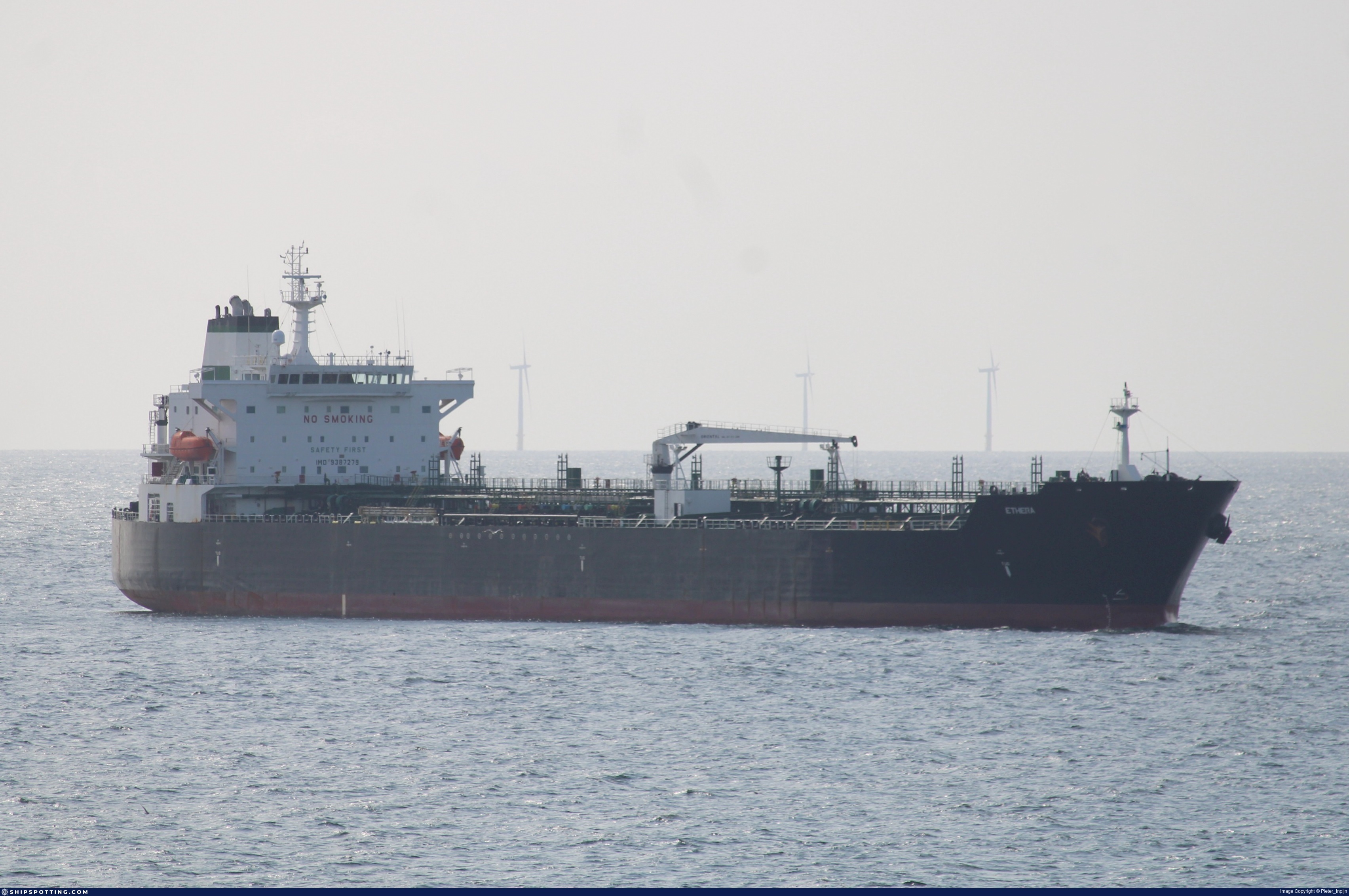
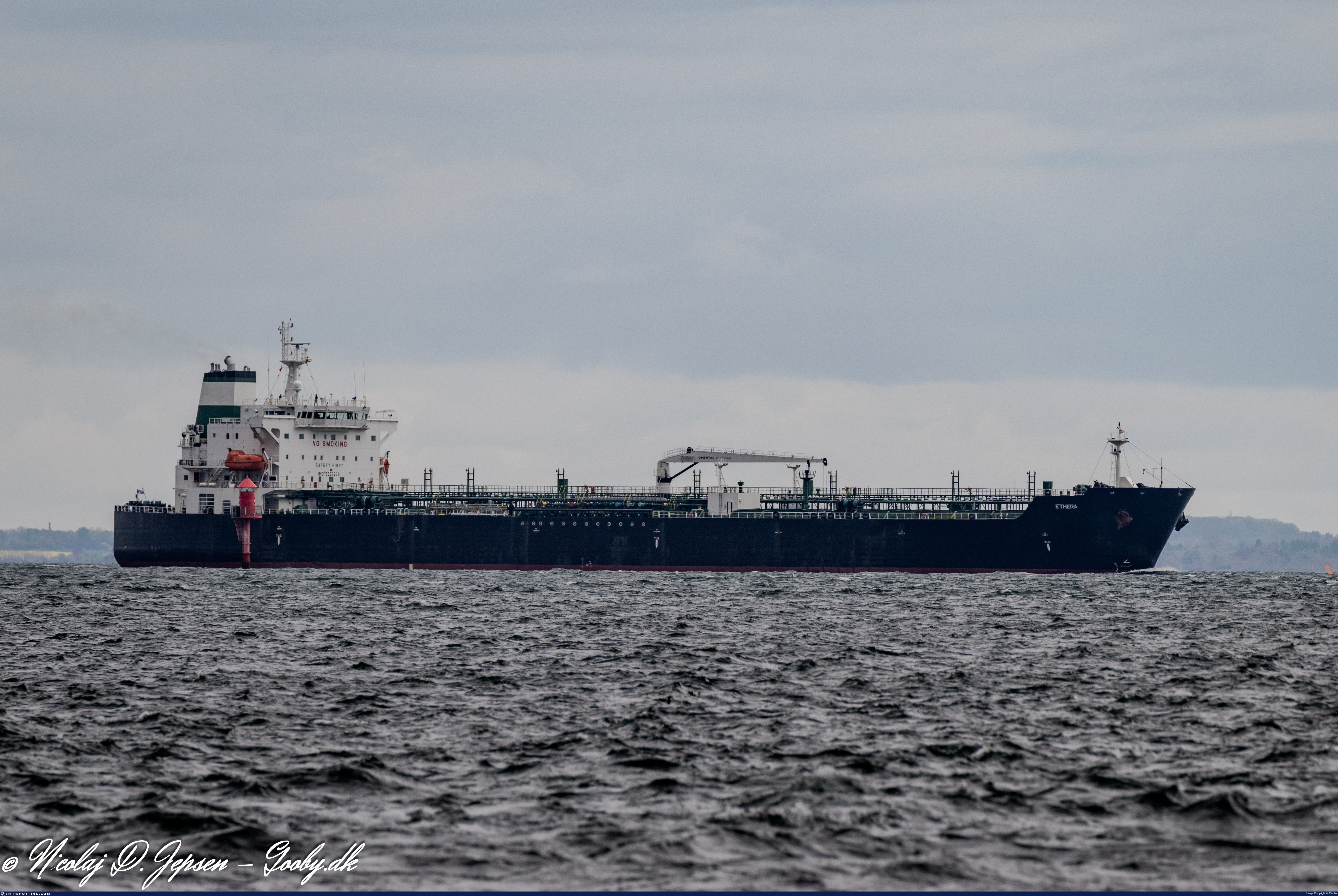
IMO 9387279
Vessel information
Vessel Name
Ethera View name history 📜
IMO Number
9387279
MMSI
632001149
Vessel Type
Chemical/Oil Products Tanker | Navire-citerne pour produits pétroliers/ transporteur de produits chimiques
Flag
🇬🇳 Guinea View flag history 📜
Call Sign
3X2122
Gross Tonnage
29,605 GT
Year Built
2008
Sanctioned by
Company & Ownership
Lago International SA
IMO Company: 6505779
Address
C/O: The Zulu Ships Management & Operation – Sole Proprietorship LLC Office 105, Madinat Zayed Tower, Muroor Road, Abu Dhabi, United Arab Emirates.
Status
Active
Fleet
1.0 owner, 0.0 operator, 0.0 manager, 0.0 beneficial
Management & Operations
ISM Manager
UNKNOWN
Unknown
Commercial Manager
FLEET ARMADA PVT LTD
Classification & Safety
Current Classification
Alfa Register of Shipping
Delivered
Port State Control (PSC) Inspections
Risk Level
LOW
Last 36 Months
4
Inspections
Last Inspection
📍 Istanbul
📅 2025-12-04
Survey Renewal & Certificates
| Code | Type | Issuer | Issued | Expires |
|---|---|---|---|---|
| 511 | International Ship Security | Panama | 09/12/2023 | 16/08/2028 |
| 533 | Maritime Labour Certificate | BV | 01/10/2024 | 16/08/2028 |
Programs & Notes
EU Russia Sanctions – Shadow Fleet | SEMA (Canada) — vessel designations | The Russia (Sanctions) (EU Exit) Regulations 2019
Vessel Changes
 🔄 Owner
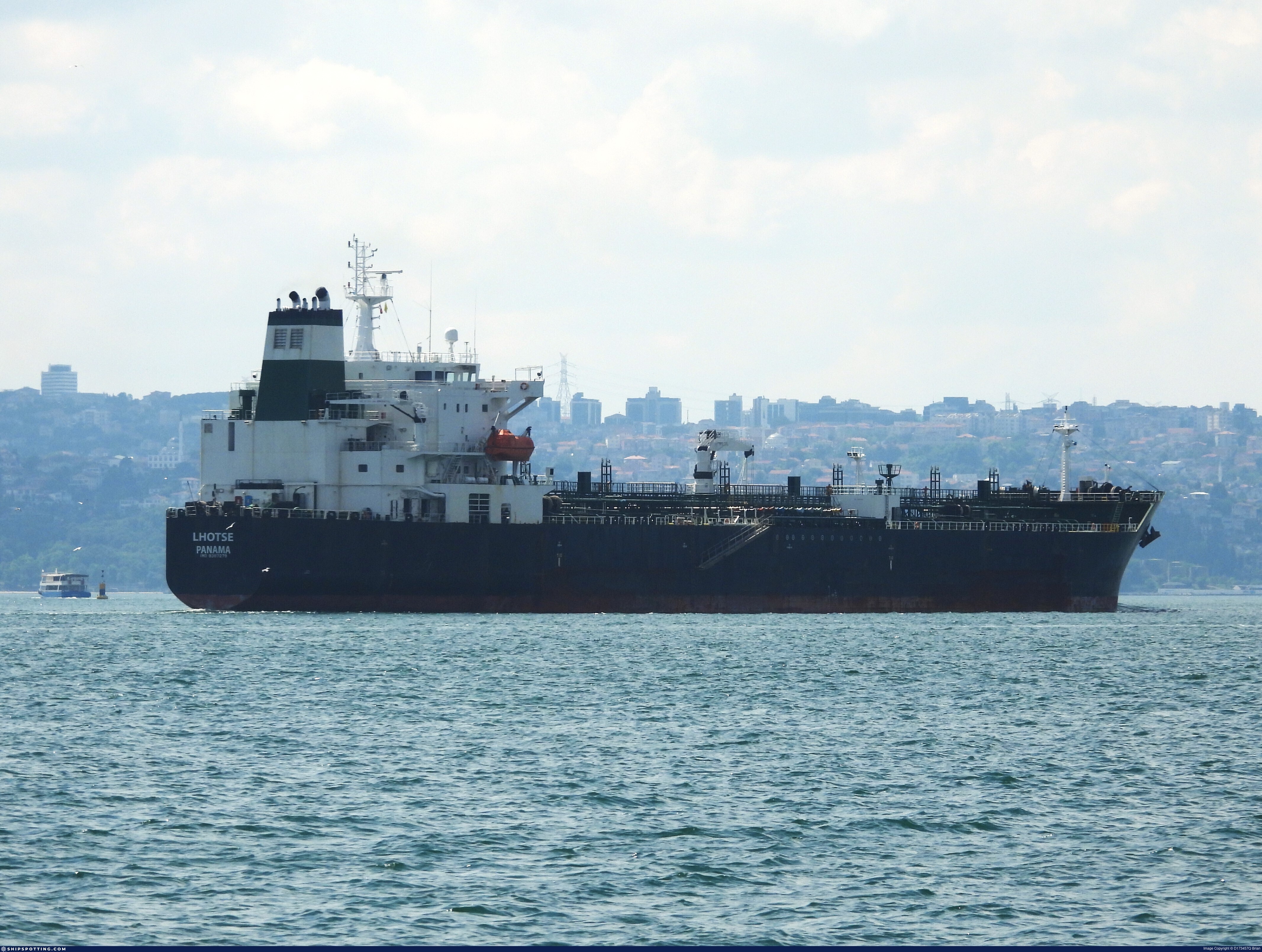
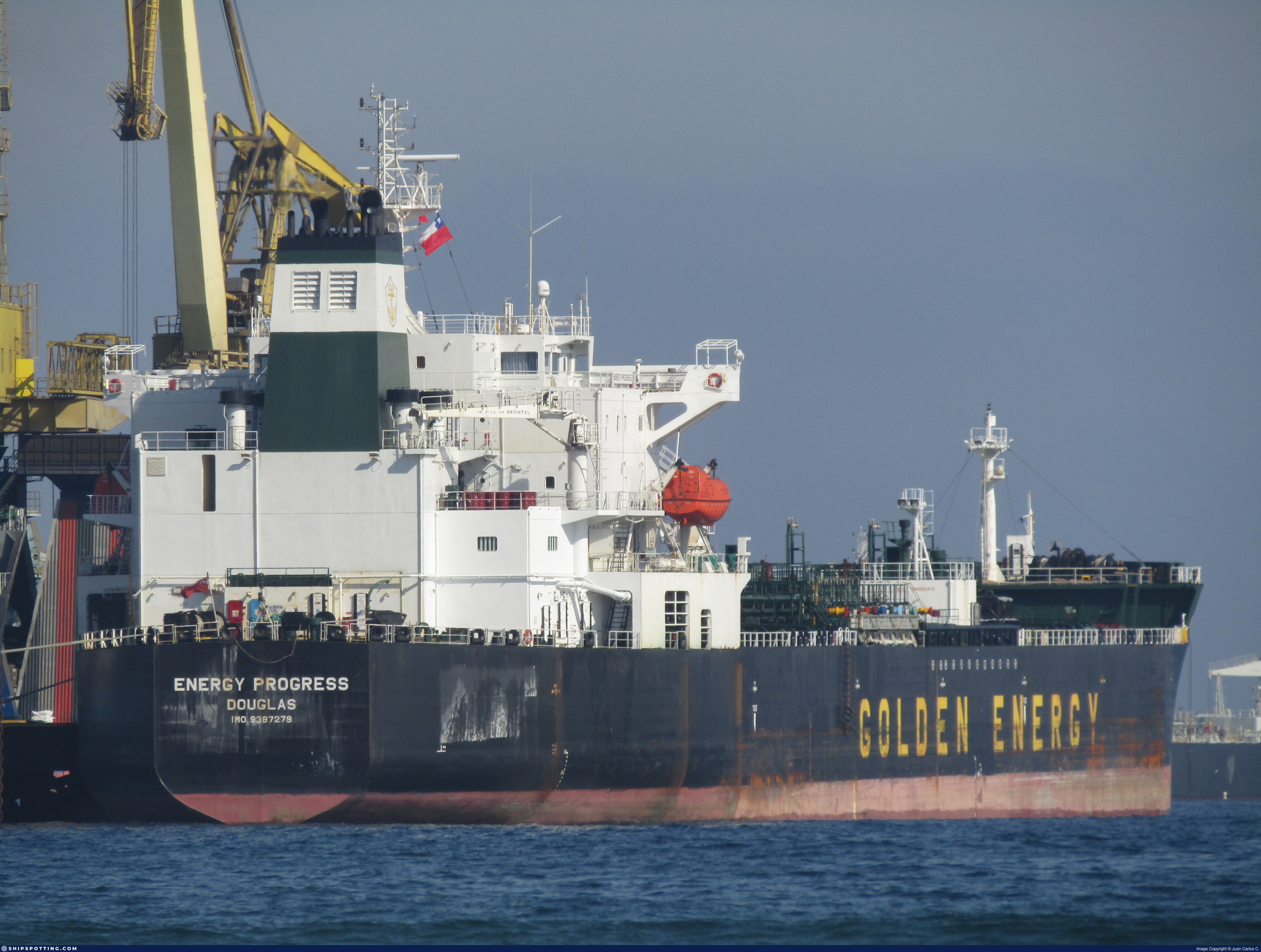
ENERGY PROGRESS (now ETHERA)
IMO 9387279
RIVERSTONE MARINE LTD
→
OCEAN TONE SHIPPING LTD
Oct 9, 2019
AIS Events
50 events detected • 1 zone • Last: Jul 22, 2026
Loiter
English Channel Surveillance Zone
Jul 22, 2026 18:55 UTC
75.0%
- Duration: 2h 57m
- Radius: 6 meters
- Data Points: 21 AIS positions
- Centroid: 51.3390, 3.1956
- Zone: English Channel Surveillance Zone
Show Raw Evidence JSON
{
    "radius_m": 6.20000000000000017763568394002504646778106689453125,
    "duration_minutes": 177,
    "points": 21,
    "centroid": {
        "lat": 51.33895166666667364552267827093601226806640625,
        "lon": 3.19561928571428577328106257482431828975677490234375
    },
    "bbox": {
        "min_lat": 51.3389250000000032514435588382184505462646484375,
        "min_lon": 3.1955749999999998323119143606163561344146728515625,
        "max_lat": 51.339006699999998772909748367965221405029296875,
        "max_lon": 3.19567330000000016099193089758045971393585205078125
    },
    "zone_id": "discovered_004"
}
Zone Dwell
English Channel Surveillance Zone
Jul 22, 2026 18:55 UTC
80.0%
- Zone: English Channel Surveillance Zone
- Duration: 2h 57m
- Data Points: 21 AIS positions
- Period: 2026-07-22T18:55:22+00:00 to 2026-07-22T21:52:23+00:00
Show Raw Evidence JSON
{
    "zone_id": "discovered_004",
    "zone_name": "English Channel Surveillance Zone",
    "dwell_minutes": 177,
    "points_in_zone": 21,
    "first_point": {
        "ts": "2026-07-22T18:55:22+00:00",
        "lat": 51.33893830000000235713741858489811420440673828125,
        "lon": 3.1956483000000002192564352299086749553680419921875
    },
    "last_point": {
        "ts": "2026-07-22T21:52:23+00:00",
        "lat": 51.33894500000000249428921961225569248199462890625,
        "lon": 3.19564000000000003609557097661308944225311279296875
    }
}
Loiter
English Channel Surveillance Zone
Jul 22, 2026 07:04 UTC
75.0%
- Duration: 1h 33m
- Radius: 8 meters
- Data Points: 30 AIS positions
- Centroid: 51.3389, 3.1956
- Zone: English Channel Surveillance Zone
Show Raw Evidence JSON
{
    "radius_m": 8,
    "duration_minutes": 93,
    "points": 30,
    "centroid": {
        "lat": 51.33893567333334573277170420624315738677978515625,
        "lon": 3.19562895000000057876832215697504580020904541015625
    },
    "bbox": {
        "min_lat": 51.33889500000000083446138887666165828704833984375,
        "min_lon": 3.195571699999999903951675150892697274684906005859375,
        "max_lat": 51.339006699999998772909748367965221405029296875,
        "max_lon": 3.195679999999999854054522074875421822071075439453125
    },
    "zone_id": "discovered_004"
}
Zone Dwell
English Channel Surveillance Zone
Jul 22, 2026 07:04 UTC
80.0%
- Zone: English Channel Surveillance Zone
- Duration: 1h 33m
- Data Points: 30 AIS positions
- Period: 2026-07-22T07:04:24+00:00 to 2026-07-22T08:37:23+00:00
Show Raw Evidence JSON
{
    "zone_id": "discovered_004",
    "zone_name": "English Channel Surveillance Zone",
    "dwell_minutes": 93,
    "points_in_zone": 30,
    "first_point": {
        "ts": "2026-07-22T07:04:24+00:00",
        "lat": 51.3389499999999969759301166050136089324951171875,
        "lon": 3.195629999999999970583530739531852304935455322265625
    },
    "last_point": {
        "ts": "2026-07-22T08:37:23+00:00",
        "lat": 51.3389533000000000129148247651755809783935546875,
        "lon": 3.1956199999999999050714905024506151676177978515625
    }
}
Loiter
English Channel Surveillance Zone
Jul 22, 2026 06:04 UTC
75.0%
- Duration: 2h 33m
- Radius: 8 meters
- Data Points: 49 AIS positions
- Centroid: 51.3389, 3.1956
- Zone: English Channel Surveillance Zone
Show Raw Evidence JSON
{
    "radius_m": 8.300000000000000710542735760100185871124267578125,
    "duration_minutes": 153,
    "points": 49,
    "centroid": {
        "lat": 51.33893455714286346847075037658214569091796875,
        "lon": 3.19562926122448942578557762317359447479248046875
    },
    "bbox": {
        "min_lat": 51.33886830000000145446392707526683807373046875,
        "min_lon": 3.195571699999999903951675150892697274684906005859375,
        "max_lat": 51.339006699999998772909748367965221405029296875,
        "max_lon": 3.19570169999999986742977853282354772090911865234375
    },
    "zone_id": "discovered_004"
}
Zone Dwell
English Channel Surveillance Zone
Jul 22, 2026 06:04 UTC
80.0%
- Zone: English Channel Surveillance Zone
- Duration: 2h 33m
- Data Points: 49 AIS positions
- Period: 2026-07-22T06:04:23+00:00 to 2026-07-22T08:37:23+00:00
Show Raw Evidence JSON
{
    "zone_id": "discovered_004",
    "zone_name": "English Channel Surveillance Zone",
    "dwell_minutes": 153,
    "points_in_zone": 49,
    "first_point": {
        "ts": "2026-07-22T06:04:23+00:00",
        "lat": 51.33897329999999925576048553921282291412353515625,
        "lon": 3.195573299999999949960738376830704510211944580078125
    },
    "last_point": {
        "ts": "2026-07-22T08:37:23+00:00",
        "lat": 51.3389533000000000129148247651755809783935546875,
        "lon": 3.1956199999999999050714905024506151676177978515625
    }
}
Loiter
English Channel Surveillance Zone
Jul 22, 2026 05:01 UTC
75.0%
- Duration: 3h 36m
- Radius: 9 meters
- Data Points: 66 AIS positions
- Centroid: 51.3389, 3.1956
- Zone: English Channel Surveillance Zone
Show Raw Evidence JSON
{
    "radius_m": 9.0999999999999996447286321199499070644378662109375,
    "duration_minutes": 216,
    "points": 66,
    "centroid": {
        "lat": 51.33894204393939020292236818931996822357177734375,
        "lon": 3.195627910606061217180240419111214578151702880859375
    },
    "bbox": {
        "min_lat": 51.33886830000000145446392707526683807373046875,
        "min_lon": 3.195571699999999903951675150892697274684906005859375,
        "max_lat": 51.339006699999998772909748367965221405029296875,
        "max_lon": 3.19570169999999986742977853282354772090911865234375
    },
    "zone_id": "discovered_004"
}
Zone Dwell
English Channel Surveillance Zone
Jul 22, 2026 05:01 UTC
80.0%
- Zone: English Channel Surveillance Zone
- Duration: 3h 36m
- Data Points: 66 AIS positions
- Period: 2026-07-22T05:01:25+00:00 to 2026-07-22T08:37:23+00:00
Show Raw Evidence JSON
{
    "zone_id": "discovered_004",
    "zone_name": "English Channel Surveillance Zone",
    "dwell_minutes": 216,
    "points_in_zone": 66,
    "first_point": {
        "ts": "2026-07-22T05:01:25+00:00",
        "lat": 51.3389600000000001500666257925331592559814453125,
        "lon": 3.195625000000000159872115546022541821002960205078125
    },
    "last_point": {
        "ts": "2026-07-22T08:37:23+00:00",
        "lat": 51.3389533000000000129148247651755809783935546875,
        "lon": 3.1956199999999999050714905024506151676177978515625
    }
}
Loiter
English Channel Surveillance Zone
Jul 22, 2026 04:52 UTC
75.0%
- Duration: 3h 45m
- Radius: 9 meters
- Data Points: 67 AIS positions
- Centroid: 51.3389, 3.1956
- Zone: English Channel Surveillance Zone
Show Raw Evidence JSON
{
    "radius_m": 9.0999999999999996447286321199499070644378662109375,
    "duration_minutes": 225,
    "points": 67,
    "centroid": {
        "lat": 51.33894213731343114659466664306819438934326171875,
        "lon": 3.195627867164180013759278153884224593639373779296875
    },
    "bbox": {
        "min_lat": 51.33886830000000145446392707526683807373046875,
        "min_lon": 3.195571699999999903951675150892697274684906005859375,
        "max_lat": 51.339006699999998772909748367965221405029296875,
        "max_lon": 3.19570169999999986742977853282354772090911865234375
    },
    "zone_id": "discovered_004"
}
Zone Dwell
English Channel Surveillance Zone
Jul 22, 2026 04:52 UTC
80.0%
- Zone: English Channel Surveillance Zone
- Duration: 3h 45m
- Data Points: 67 AIS positions
- Period: 2026-07-22T04:52:24+00:00 to 2026-07-22T08:37:23+00:00
Show Raw Evidence JSON
{
    "zone_id": "discovered_004",
    "zone_name": "English Channel Surveillance Zone",
    "dwell_minutes": 225,
    "points_in_zone": 67,
    "first_point": {
        "ts": "2026-07-22T04:52:24+00:00",
        "lat": 51.338948299999998425846570171415805816650390625,
        "lon": 3.195625000000000159872115546022541821002960205078125
    },
    "last_point": {
        "ts": "2026-07-22T08:37:23+00:00",
        "lat": 51.3389533000000000129148247651755809783935546875,
        "lon": 3.1956199999999999050714905024506151676177978515625
    }
}
Loiter
English Channel Surveillance Zone
Jul 19, 2026 22:16 UTC
75.0%
- Duration: 1h 42m
- Radius: 6 meters
- Data Points: 15 AIS positions
- Centroid: 51.3389, 3.1957
- Zone: English Channel Surveillance Zone
Show Raw Evidence JSON
{
    "radius_m": 5.79999999999999982236431605997495353221893310546875,
    "duration_minutes": 102,
    "points": 15,
    "centroid": {
        "lat": 51.338926106666662008137791417539119720458984375,
        "lon": 3.195650326666666263264460212667472660541534423828125
    },
    "bbox": {
        "min_lat": 51.338875000000001591615728102624416351318359375,
        "min_lon": 3.195629999999999970583530739531852304935455322265625,
        "max_lat": 51.33897329999999925576048553921282291412353515625,
        "max_lon": 3.195698300000000102727426565252244472503662109375
    },
    "zone_id": "discovered_004"
}
Zone Dwell
English Channel Surveillance Zone
Jul 19, 2026 22:16 UTC
80.0%
- Zone: English Channel Surveillance Zone
- Duration: 1h 42m
- Data Points: 15 AIS positions
- Period: 2026-07-19T22:16:23+00:00 to 2026-07-19T23:58:23+00:00
Show Raw Evidence JSON
{
    "zone_id": "discovered_004",
    "zone_name": "English Channel Surveillance Zone",
    "dwell_minutes": 102,
    "points_in_zone": 15,
    "first_point": {
        "ts": "2026-07-19T22:16:23+00:00",
        "lat": 51.3389116999999970403223414905369281768798828125,
        "lon": 3.195698300000000102727426565252244472503662109375
    },
    "last_point": {
        "ts": "2026-07-19T23:58:23+00:00",
        "lat": 51.33893499999999932015271042473614215850830078125,
        "lon": 3.19563329999999989894376994925551116466522216796875
    }
}
Loiter
English Channel Surveillance Zone
Jul 19, 2026 21:01 UTC
75.0%
- Duration: 2h 57m
- Radius: 9 meters
- Data Points: 23 AIS positions
- Centroid: 51.3389, 3.1956
- Zone: English Channel Surveillance Zone
Show Raw Evidence JSON
{
    "radius_m": 8.9000000000000003552713678800500929355621337890625,
    "duration_minutes": 177,
    "points": 23,
    "centroid": {
        "lat": 51.3389431869565129318289109505712985992431640625,
        "lon": 3.19564405652173899596846240456216037273406982421875
    },
    "bbox": {
        "min_lat": 51.338875000000001591615728102624416351318359375,
        "min_lon": 3.195600000000000218136619878350757062435150146484375,
        "max_lat": 51.33902330000000091558831627480685710906982421875,
        "max_lon": 3.195698300000000102727426565252244472503662109375
    },
    "zone_id": "discovered_004"
}
Zone Dwell
English Channel Surveillance Zone
Jul 19, 2026 21:01 UTC
80.0%
- Zone: English Channel Surveillance Zone
- Duration: 2h 57m
- Data Points: 23 AIS positions
- Period: 2026-07-19T21:01:23+00:00 to 2026-07-19T23:58:23+00:00
Show Raw Evidence JSON
{
    "zone_id": "discovered_004",
    "zone_name": "English Channel Surveillance Zone",
    "dwell_minutes": 177,
    "points_in_zone": 23,
    "first_point": {
        "ts": "2026-07-19T21:01:23+00:00",
        "lat": 51.33893499999999932015271042473614215850830078125,
        "lon": 3.195600000000000218136619878350757062435150146484375
    },
    "last_point": {
        "ts": "2026-07-19T23:58:23+00:00",
        "lat": 51.33893499999999932015271042473614215850830078125,
        "lon": 3.19563329999999989894376994925551116466522216796875
    }
}
Loiter
English Channel Surveillance Zone
Jul 19, 2026 20:07 UTC
75.0%
- Duration: 3h 51m
- Radius: 9 meters
- Data Points: 28 AIS positions
- Centroid: 51.3389, 3.1956
- Zone: English Channel Surveillance Zone
Show Raw Evidence JSON
{
    "radius_m": 8.9000000000000003552713678800500929355621337890625,
    "duration_minutes": 231,
    "points": 28,
    "centroid": {
        "lat": 51.33894333214285410349475569091737270355224609375,
        "lon": 3.19564047857142785602491130703128874301910400390625
    },
    "bbox": {
        "min_lat": 51.338875000000001591615728102624416351318359375,
        "min_lon": 3.195600000000000218136619878350757062435150146484375,
        "max_lat": 51.33902330000000091558831627480685710906982421875,
        "max_lon": 3.195698300000000102727426565252244472503662109375
    },
    "zone_id": "discovered_004"
}
Zone Dwell
English Channel Surveillance Zone
Jul 19, 2026 20:07 UTC
80.0%
- Zone: English Channel Surveillance Zone
- Duration: 3h 51m
- Data Points: 28 AIS positions
- Period: 2026-07-19T20:07:22+00:00 to 2026-07-19T23:58:23+00:00
Show Raw Evidence JSON
{
    "zone_id": "discovered_004",
    "zone_name": "English Channel Surveillance Zone",
    "dwell_minutes": 231,
    "points_in_zone": 28,
    "first_point": {
        "ts": "2026-07-19T20:07:22+00:00",
        "lat": 51.3389317000000033885953598655760288238525390625,
        "lon": 3.1956267000000000422232915298081934452056884765625
    },
    "last_point": {
        "ts": "2026-07-19T23:58:23+00:00",
        "lat": 51.33893499999999932015271042473614215850830078125,
        "lon": 3.19563329999999989894376994925551116466522216796875
    }
}
Loiter
English Channel Surveillance Zone
Jul 19, 2026 19:19 UTC
75.0%
- Duration: 4h 39m
- Radius: 9 meters
- Data Points: 34 AIS positions
- Centroid: 51.3389, 3.1956
- Zone: English Channel Surveillance Zone
Show Raw Evidence JSON
{
    "radius_m": 9.199999999999999289457264239899814128875732421875,
    "duration_minutes": 279,
    "points": 34,
    "centroid": {
        "lat": 51.33894112647059415621697553433477878570556640625,
        "lon": 3.1956394147058819754647629451937973499298095703125
    },
    "bbox": {
        "min_lat": 51.338875000000001591615728102624416351318359375,
        "min_lon": 3.195600000000000218136619878350757062435150146484375,
        "max_lat": 51.33902330000000091558831627480685710906982421875,
        "max_lon": 3.195698300000000102727426565252244472503662109375
    },
    "zone_id": "discovered_004"
}
Zone Dwell
English Channel Surveillance Zone
Jul 19, 2026 19:19 UTC
80.0%
- Zone: English Channel Surveillance Zone
- Duration: 4h 39m
- Data Points: 34 AIS positions
- Period: 2026-07-19T19:19:24+00:00 to 2026-07-19T23:58:23+00:00
Show Raw Evidence JSON
{
    "zone_id": "discovered_004",
    "zone_name": "English Channel Surveillance Zone",
    "dwell_minutes": 279,
    "points_in_zone": 34,
    "first_point": {
        "ts": "2026-07-19T19:19:24+00:00",
        "lat": 51.3389432999999968387783155776560306549072265625,
        "lon": 3.19564000000000003609557097661308944225311279296875
    },
    "last_point": {
        "ts": "2026-07-19T23:58:23+00:00",
        "lat": 51.33893499999999932015271042473614215850830078125,
        "lon": 3.19563329999999989894376994925551116466522216796875
    }
}
Loiter
English Channel Surveillance Zone
Jul 19, 2026 18:28 UTC
75.0%
- Duration: 5h 30m
- Radius: 9 meters
- Data Points: 36 AIS positions
- Centroid: 51.3389, 3.1956
- Zone: English Channel Surveillance Zone
Show Raw Evidence JSON
{
    "radius_m": 9.199999999999999289457264239899814128875732421875,
    "duration_minutes": 330,
    "points": 36,
    "centroid": {
        "lat": 51.33894046388889620402551372535526752471923828125,
        "lon": 3.195640741666666340137226143269799649715423583984375
    },
    "bbox": {
        "min_lat": 51.338875000000001591615728102624416351318359375,
        "min_lon": 3.195600000000000218136619878350757062435150146484375,
        "max_lat": 51.33902330000000091558831627480685710906982421875,
        "max_lon": 3.195698300000000102727426565252244472503662109375
    },
    "zone_id": "discovered_004"
}
Zone Dwell
English Channel Surveillance Zone
Jul 19, 2026 18:28 UTC
80.0%
- Zone: English Channel Surveillance Zone
- Duration: 5h 30m
- Data Points: 36 AIS positions
- Period: 2026-07-19T18:28:24+00:00 to 2026-07-19T23:58:23+00:00
Show Raw Evidence JSON
{
    "zone_id": "discovered_004",
    "zone_name": "English Channel Surveillance Zone",
    "dwell_minutes": 330,
    "points_in_zone": 36,
    "first_point": {
        "ts": "2026-07-19T18:28:24+00:00",
        "lat": 51.338916699999998627390596084296703338623046875,
        "lon": 3.19568329999999978241476128459908068180084228515625
    },
    "last_point": {
        "ts": "2026-07-19T23:58:23+00:00",
        "lat": 51.33893499999999932015271042473614215850830078125,
        "lon": 3.19563329999999989894376994925551116466522216796875
    }
}
Loiter
English Channel Surveillance Zone
Jul 19, 2026 17:01 UTC
75.0%
- Duration: 6h 33m
- Radius: 9 meters
- Data Points: 37 AIS positions
- Centroid: 51.3389, 3.1956
- Zone: English Channel Surveillance Zone
Show Raw Evidence JSON
{
    "radius_m": 9.0999999999999996447286321199499070644378662109375,
    "duration_minutes": 393,
    "points": 37,
    "centroid": {
        "lat": 51.3389412621621659127413295209407806396484375,
        "lon": 3.195640135135134674015944256098009645938873291015625
    },
    "bbox": {
        "min_lat": 51.338875000000001591615728102624416351318359375,
        "min_lon": 3.195600000000000218136619878350757062435150146484375,
        "max_lat": 51.33902330000000091558831627480685710906982421875,
        "max_lon": 3.195698300000000102727426565252244472503662109375
    },
    "zone_id": "discovered_004"
}
Zone Dwell
English Channel Surveillance Zone
Jul 19, 2026 17:01 UTC
80.0%
- Zone: English Channel Surveillance Zone
- Duration: 6h 33m
- Data Points: 37 AIS positions
- Period: 2026-07-19T17:25:22+00:00 to 2026-07-19T23:58:23+00:00
Show Raw Evidence JSON
{
    "zone_id": "discovered_004",
    "zone_name": "English Channel Surveillance Zone",
    "dwell_minutes": 393,
    "points_in_zone": 37,
    "first_point": {
        "ts": "2026-07-19T17:25:22+00:00",
        "lat": 51.3389700000000033242031349800527095794677734375,
        "lon": 3.195618300000000022720314518664963543415069580078125
    },
    "last_point": {
        "ts": "2026-07-19T23:58:23+00:00",
        "lat": 51.33893499999999932015271042473614215850830078125,
        "lon": 3.19563329999999989894376994925551116466522216796875
    }
}
Loiter
English Channel Surveillance Zone
Jul 19, 2026 16:01 UTC
75.0%
- Duration: 6h 33m
- Radius: 9 meters
- Data Points: 34 AIS positions
- Centroid: 51.3389, 3.1956
- Zone: English Channel Surveillance Zone
Show Raw Evidence JSON
{
    "radius_m": 8.699999999999999289457264239899814128875732421875,
    "duration_minutes": 393,
    "points": 34,
    "centroid": {
        "lat": 51.33894519999999062065398902632296085357666015625,
        "lon": 3.195634758823528986937390072853304445743560791015625
    },
    "bbox": {
        "min_lat": 51.338875000000001591615728102624416351318359375,
        "min_lon": 3.195600000000000218136619878350757062435150146484375,
        "max_lat": 51.33902330000000091558831627480685710906982421875,
        "max_lon": 3.195698300000000102727426565252244472503662109375
    },
    "zone_id": "discovered_004"
}
Zone Dwell
English Channel Surveillance Zone
Jul 19, 2026 16:01 UTC
80.0%
- Zone: English Channel Surveillance Zone
- Duration: 6h 33m
- Data Points: 34 AIS positions
- Period: 2026-07-19T16:46:26+00:00 to 2026-07-19T23:19:24+00:00
Show Raw Evidence JSON
{
    "zone_id": "discovered_004",
    "zone_name": "English Channel Surveillance Zone",
    "dwell_minutes": 393,
    "points_in_zone": 34,
    "first_point": {
        "ts": "2026-07-19T16:46:26+00:00",
        "lat": 51.33892829999999918300090939737856388092041015625,
        "lon": 3.195608299999999957208274281583726406097412109375
    },
    "last_point": {
        "ts": "2026-07-19T23:19:24+00:00",
        "lat": 51.338875000000001591615728102624416351318359375,
        "lon": 3.19563329999999989894376994925551116466522216796875
    }
}
Loiter
English Channel Surveillance Zone
Jul 19, 2026 15:01 UTC
75.0%
- Duration: 6h 33m
- Radius: 8 meters
- Data Points: 32 AIS positions
- Centroid: 51.3389, 3.1956
- Zone: English Channel Surveillance Zone
Show Raw Evidence JSON
{
    "radius_m": 8.199999999999999289457264239899814128875732421875,
    "duration_minutes": 393,
    "points": 32,
    "centroid": {
        "lat": 51.3389497968749850542735657654702663421630859375,
        "lon": 3.19563531874999995352482073940336704254150390625
    },
    "bbox": {
        "min_lat": 51.3389116999999970403223414905369281768798828125,
        "min_lon": 3.195600000000000218136619878350757062435150146484375,
        "max_lat": 51.33902330000000091558831627480685710906982421875,
        "max_lon": 3.195698300000000102727426565252244472503662109375
    },
    "zone_id": "discovered_004"
}
Zone Dwell
English Channel Surveillance Zone
Jul 19, 2026 15:01 UTC
80.0%
- Zone: English Channel Surveillance Zone
- Duration: 6h 33m
- Data Points: 32 AIS positions
- Period: 2026-07-19T15:52:23+00:00 to 2026-07-19T22:25:23+00:00
Show Raw Evidence JSON
{
    "zone_id": "discovered_004",
    "zone_name": "English Channel Surveillance Zone",
    "dwell_minutes": 393,
    "points_in_zone": 32,
    "first_point": {
        "ts": "2026-07-19T15:52:23+00:00",
        "lat": 51.33893330000000077006916399113833904266357421875,
        "lon": 3.19565169999999998395878719747997820377349853515625
    },
    "last_point": {
        "ts": "2026-07-19T22:25:23+00:00",
        "lat": 51.338916699999998627390596084296703338623046875,
        "lon": 3.19564670000000017324737200397066771984100341796875
    }
}
Loiter
English Channel Surveillance Zone
Jul 19, 2026 14:07 UTC
75.0%
- Duration: 6h 21m
- Radius: 5 meters
- Data Points: 31 AIS positions
- Centroid: 51.3389, 3.1956
- Zone: English Channel Surveillance Zone
Show Raw Evidence JSON
{
    "radius_m": 4.70000000000000017763568394002504646778106689453125,
    "duration_minutes": 381,
    "points": 31,
    "centroid": {
        "lat": 51.3389435516128997960549895651638507843017578125,
        "lon": 3.1956309193548388947192506748251616954803466796875
    },
    "bbox": {
        "min_lat": 51.3389116999999970403223414905369281768798828125,
        "min_lon": 3.195600000000000218136619878350757062435150146484375,
        "max_lat": 51.33898169999999794299583300016820430755615234375,
        "max_lon": 3.19568329999999978241476128459908068180084228515625
    },
    "zone_id": "discovered_004"
}
Zone Dwell
English Channel Surveillance Zone
Jul 19, 2026 14:07 UTC
80.0%
- Zone: English Channel Surveillance Zone
- Duration: 6h 21m
- Data Points: 31 AIS positions
- Period: 2026-07-19T14:55:24+00:00 to 2026-07-19T21:16:22+00:00
Show Raw Evidence JSON
{
    "zone_id": "discovered_004",
    "zone_name": "English Channel Surveillance Zone",
    "dwell_minutes": 381,
    "points_in_zone": 31,
    "first_point": {
        "ts": "2026-07-19T14:55:24+00:00",
        "lat": 51.3389317000000033885953598655760288238525390625,
        "lon": 3.195643299999999964455810186336748301982879638671875
    },
    "last_point": {
        "ts": "2026-07-19T21:16:22+00:00",
        "lat": 51.3389633000000031870513339526951313018798828125,
        "lon": 3.1956483000000002192564352299086749553680419921875
    }
}
Loiter
English Channel Surveillance Zone
Jul 19, 2026 13:01 UTC
75.0%
- Duration: 6h 36m
- Radius: 5 meters
- Data Points: 27 AIS positions
- Centroid: 51.3389, 3.1956
- Zone: English Channel Surveillance Zone
Show Raw Evidence JSON
{
    "radius_m": 4.5999999999999996447286321199499070644378662109375,
    "duration_minutes": 396,
    "points": 27,
    "centroid": {
        "lat": 51.338944200000014461693353950977325439453125,
        "lon": 3.19563376666666609793310271925292909145355224609375
    },
    "bbox": {
        "min_lat": 51.3389116999999970403223414905369281768798828125,
        "min_lon": 3.195600000000000218136619878350757062435150146484375,
        "max_lat": 51.33898169999999794299583300016820430755615234375,
        "max_lon": 3.19568329999999978241476128459908068180084228515625
    },
    "zone_id": "discovered_004"
}
Zone Dwell
English Channel Surveillance Zone
Jul 19, 2026 13:01 UTC
80.0%
- Zone: English Channel Surveillance Zone
- Duration: 6h 36m
- Data Points: 27 AIS positions
- Period: 2026-07-19T13:31:22+00:00 to 2026-07-19T20:07:22+00:00
Show Raw Evidence JSON
{
    "zone_id": "discovered_004",
    "zone_name": "English Channel Surveillance Zone",
    "dwell_minutes": 396,
    "points_in_zone": 27,
    "first_point": {
        "ts": "2026-07-19T13:31:22+00:00",
        "lat": 51.3389700000000033242031349800527095794677734375,
        "lon": 3.19564670000000017324737200397066771984100341796875
    },
    "last_point": {
        "ts": "2026-07-19T20:07:22+00:00",
        "lat": 51.3389317000000033885953598655760288238525390625,
        "lon": 3.1956267000000000422232915298081934452056884765625
    }
}
Loiter
English Channel Surveillance Zone
Jul 19, 2026 12:01 UTC
75.0%
- Duration: 6h 24m
- Radius: 5 meters
- Data Points: 27 AIS positions
- Centroid: 51.3389, 3.1956
- Zone: English Channel Surveillance Zone
Show Raw Evidence JSON
{
    "radius_m": 4.9000000000000003552713678800500929355621337890625,
    "duration_minutes": 384,
    "points": 27,
    "centroid": {
        "lat": 51.3389493814814983352334820665419101715087890625,
        "lon": 3.19563691481481537692843630793504416942596435546875
    },
    "bbox": {
        "min_lat": 51.338916699999998627390596084296703338623046875,
        "min_lon": 3.195600000000000218136619878350757062435150146484375,
        "max_lat": 51.33898169999999794299583300016820430755615234375,
        "max_lon": 3.19568329999999978241476128459908068180084228515625
    },
    "zone_id": "discovered_004"
}
Zone Dwell
English Channel Surveillance Zone
Jul 19, 2026 12:01 UTC
80.0%
- Zone: English Channel Surveillance Zone
- Duration: 6h 24m
- Data Points: 27 AIS positions
- Period: 2026-07-19T12:55:23+00:00 to 2026-07-19T19:19:24+00:00
Show Raw Evidence JSON
{
    "zone_id": "discovered_004",
    "zone_name": "English Channel Surveillance Zone",
    "dwell_minutes": 384,
    "points_in_zone": 27,
    "first_point": {
        "ts": "2026-07-19T12:55:23+00:00",
        "lat": 51.3389667000000002872184268198907375335693359375,
        "lon": 3.1956199999999999050714905024506151676177978515625
    },
    "last_point": {
        "ts": "2026-07-19T19:19:24+00:00",
        "lat": 51.3389432999999968387783155776560306549072265625,
        "lon": 3.19564000000000003609557097661308944225311279296875
    }
}
Loiter
English Channel Surveillance Zone
Jul 19, 2026 11:04 UTC
75.0%
- Duration: 6h 21m
- Radius: 11 meters
- Data Points: 34 AIS positions
- Centroid: 51.3390, 3.1956
- Zone: English Channel Surveillance Zone
Show Raw Evidence JSON
{
    "radius_m": 11.4000000000000003552713678800500929355621337890625,
    "duration_minutes": 381,
    "points": 34,
    "centroid": {
        "lat": 51.3389524500000078433004091493785381317138671875,
        "lon": 3.195628923529410858606070178211666643619537353515625
    },
    "bbox": {
        "min_lat": 51.3389150000000000773070496506989002227783203125,
        "min_lon": 3.195518299999999811689121997915208339691162109375,
        "max_lat": 51.33902830000000250265657086856663227081298828125,
        "max_lon": 3.195675000000000043343106881366111338138580322265625
    },
    "zone_id": "discovered_004"
}
Zone Dwell
English Channel Surveillance Zone
Jul 19, 2026 11:04 UTC
80.0%
- Zone: English Channel Surveillance Zone
- Duration: 6h 21m
- Data Points: 34 AIS positions
- Period: 2026-07-19T11:04:22+00:00 to 2026-07-19T17:25:22+00:00
Show Raw Evidence JSON
{
    "zone_id": "discovered_004",
    "zone_name": "English Channel Surveillance Zone",
    "dwell_minutes": 381,
    "points_in_zone": 34,
    "first_point": {
        "ts": "2026-07-19T11:04:22+00:00",
        "lat": 51.3389150000000000773070496506989002227783203125,
        "lon": 3.1956483000000002192564352299086749553680419921875
    },
    "last_point": {
        "ts": "2026-07-19T17:25:22+00:00",
        "lat": 51.3389700000000033242031349800527095794677734375,
        "lon": 3.195618300000000022720314518664963543415069580078125
    }
}
Loiter
English Channel Surveillance Zone
Jul 19, 2026 10:16 UTC
75.0%
- Duration: 6h 33m
- Radius: 12 meters
- Data Points: 36 AIS positions
- Centroid: 51.3390, 3.1956
- Zone: English Channel Surveillance Zone
Show Raw Evidence JSON
{
    "radius_m": 11.5,
    "duration_minutes": 393,
    "points": 36,
    "centroid": {
        "lat": 51.33895240555556682693350012414157390594482421875,
        "lon": 3.195630049999999666709982193424366414546966552734375
    },
    "bbox": {
        "min_lat": 51.3389150000000000773070496506989002227783203125,
        "min_lon": 3.195518299999999811689121997915208339691162109375,
        "max_lat": 51.33902830000000250265657086856663227081298828125,
        "max_lon": 3.195675000000000043343106881366111338138580322265625
    },
    "zone_id": "discovered_004"
}
Zone Dwell
English Channel Surveillance Zone
Jul 19, 2026 10:16 UTC
80.0%
- Zone: English Channel Surveillance Zone
- Duration: 6h 33m
- Data Points: 36 AIS positions
- Period: 2026-07-19T10:52:22+00:00 to 2026-07-19T17:25:22+00:00
Show Raw Evidence JSON
{
    "zone_id": "discovered_004",
    "zone_name": "English Channel Surveillance Zone",
    "dwell_minutes": 393,
    "points_in_zone": 36,
    "first_point": {
        "ts": "2026-07-19T10:52:22+00:00",
        "lat": 51.33897329999999925576048553921282291412353515625,
        "lon": 3.1956717000000001149828676716424524784088134765625
    },
    "last_point": {
        "ts": "2026-07-19T17:25:22+00:00",
        "lat": 51.3389700000000033242031349800527095794677734375,
        "lon": 3.195618300000000022720314518664963543415069580078125
    }
}
Loiter
English Channel Surveillance Zone
Jul 19, 2026 09:19 UTC
75.0%
- Duration: 6h 30m
- Radius: 12 meters
- Data Points: 34 AIS positions
- Centroid: 51.3390, 3.1956
- Zone: English Channel Surveillance Zone
Show Raw Evidence JSON
{
    "radius_m": 11.699999999999999289457264239899814128875732421875,
    "duration_minutes": 390,
    "points": 34,
    "centroid": {
        "lat": 51.33895191176471684002535766921937465667724609375,
        "lon": 3.1956337794117644079960882663726806640625
    },
    "bbox": {
        "min_lat": 51.3389150000000000773070496506989002227783203125,
        "min_lon": 3.195518299999999811689121997915208339691162109375,
        "max_lat": 51.33902830000000250265657086856663227081298828125,
        "max_lon": 3.195675000000000043343106881366111338138580322265625
    },
    "zone_id": "discovered_004"
}
Zone Dwell
English Channel Surveillance Zone
Jul 19, 2026 09:19 UTC
80.0%
- Zone: English Channel Surveillance Zone
- Duration: 6h 30m
- Data Points: 34 AIS positions
- Period: 2026-07-19T09:28:24+00:00 to 2026-07-19T15:58:25+00:00
Show Raw Evidence JSON
{
    "zone_id": "discovered_004",
    "zone_name": "English Channel Surveillance Zone",
    "dwell_minutes": 390,
    "points_in_zone": 34,
    "first_point": {
        "ts": "2026-07-19T09:28:24+00:00",
        "lat": 51.3389667000000002872184268198907375335693359375,
        "lon": 3.195636700000000107735331766889430582523345947265625
    },
    "last_point": {
        "ts": "2026-07-19T15:58:25+00:00",
        "lat": 51.3389600000000001500666257925331592559814453125,
        "lon": 3.195675000000000043343106881366111338138580322265625
    }
}
Loiter
English Channel Surveillance Zone
Jul 19, 2026 08:10 UTC
75.0%
- Duration: 6h 27m
- Radius: 12 meters
- Data Points: 33 AIS positions
- Centroid: 51.3390, 3.1956
- Zone: English Channel Surveillance Zone
Show Raw Evidence JSON
{
    "radius_m": 11.5999999999999996447286321199499070644378662109375,
    "duration_minutes": 387,
    "points": 33,
    "centroid": {
        "lat": 51.3389515666666653714855783618986606597900390625,
        "lon": 3.195631318181817892565277361427433788776397705078125
    },
    "bbox": {
        "min_lat": 51.3389150000000000773070496506989002227783203125,
        "min_lon": 3.195518299999999811689121997915208339691162109375,
        "max_lat": 51.33902830000000250265657086856663227081298828125,
        "max_lon": 3.195675000000000043343106881366111338138580322265625
    },
    "zone_id": "discovered_004"
}
Zone Dwell
English Channel Surveillance Zone
Jul 19, 2026 08:10 UTC
80.0%
- Zone: English Channel Surveillance Zone
- Duration: 6h 27m
- Data Points: 33 AIS positions
- Period: 2026-07-19T08:43:24+00:00 to 2026-07-19T15:10:22+00:00
Show Raw Evidence JSON
{
    "zone_id": "discovered_004",
    "zone_name": "English Channel Surveillance Zone",
    "dwell_minutes": 387,
    "points_in_zone": 33,
    "first_point": {
        "ts": "2026-07-19T08:43:24+00:00",
        "lat": 51.338948299999998425846570171415805816650390625,
        "lon": 3.195580000000000087112539404188282787799835205078125
    },
    "last_point": {
        "ts": "2026-07-19T15:10:22+00:00",
        "lat": 51.33895170000000263144102063961327075958251953125,
        "lon": 3.195641699999999918446746960398741066455841064453125
    }
}
Loiter
English Channel Surveillance Zone
Jul 19, 2026 07:07 UTC
75.0%
- Duration: 6h 36m
- Radius: 12 meters
- Data Points: 33 AIS positions
- Centroid: 51.3389, 3.1956
- Zone: English Channel Surveillance Zone
Show Raw Evidence JSON
{
    "radius_m": 11.699999999999999289457264239899814128875732421875,
    "duration_minutes": 396,
    "points": 33,
    "centroid": {
        "lat": 51.33894954242425257007198524661362171173095703125,
        "lon": 3.195630157575757746002409476204775273799896240234375
    },
    "bbox": {
        "min_lat": 51.33890000000000242152964347042143344879150390625,
        "min_lon": 3.195518299999999811689121997915208339691162109375,
        "max_lat": 51.33902830000000250265657086856663227081298828125,
        "max_lon": 3.195675000000000043343106881366111338138580322265625
    },
    "zone_id": "discovered_004"
}
Zone Dwell
English Channel Surveillance Zone
Jul 19, 2026 07:07 UTC
80.0%
- Zone: English Channel Surveillance Zone
- Duration: 6h 36m
- Data Points: 33 AIS positions
- Period: 2026-07-19T07:31:25+00:00 to 2026-07-19T14:07:23+00:00
Show Raw Evidence JSON
{
    "zone_id": "discovered_004",
    "zone_name": "English Channel Surveillance Zone",
    "dwell_minutes": 396,
    "points_in_zone": 33,
    "first_point": {
        "ts": "2026-07-19T07:31:25+00:00",
        "lat": 51.33890000000000242152964347042143344879150390625,
        "lon": 3.1956267000000000422232915298081934452056884765625
    },
    "last_point": {
        "ts": "2026-07-19T14:07:23+00:00",
        "lat": 51.338948299999998425846570171415805816650390625,
        "lon": 3.19564000000000003609557097661308944225311279296875
    }
}
Loiter
English Channel Surveillance Zone
Jul 19, 2026 06:01 UTC
75.0%
- Duration: 6h 36m
- Radius: 12 meters
- Data Points: 35 AIS positions
- Centroid: 51.3389, 3.1956
- Zone: English Channel Surveillance Zone
Show Raw Evidence JSON
{
    "radius_m": 12.0999999999999996447286321199499070644378662109375,
    "duration_minutes": 396,
    "points": 35,
    "centroid": {
        "lat": 51.33894618571429191433708183467388153076171875,
        "lon": 3.195631245714286361447875606245361268520355224609375
    },
    "bbox": {
        "min_lat": 51.33890000000000242152964347042143344879150390625,
        "min_lon": 3.195518299999999811689121997915208339691162109375,
        "max_lat": 51.33902830000000250265657086856663227081298828125,
        "max_lon": 3.195675000000000043343106881366111338138580322265625
    },
    "zone_id": "discovered_004"
}
Zone Dwell
English Channel Surveillance Zone
Jul 19, 2026 06:01 UTC
80.0%
- Zone: English Channel Surveillance Zone
- Duration: 6h 36m
- Data Points: 35 AIS positions
- Period: 2026-07-19T06:52:24+00:00 to 2026-07-19T13:28:26+00:00
Show Raw Evidence JSON
{
    "zone_id": "discovered_004",
    "zone_name": "English Channel Surveillance Zone",
    "dwell_minutes": 396,
    "points_in_zone": 35,
    "first_point": {
        "ts": "2026-07-19T06:52:24+00:00",
        "lat": 51.33893830000000235713741858489811420440673828125,
        "lon": 3.195636700000000107735331766889430582523345947265625
    },
    "last_point": {
        "ts": "2026-07-19T13:28:26+00:00",
        "lat": 51.3389633000000031870513339526951313018798828125,
        "lon": 3.19565169999999998395878719747997820377349853515625
    }
}
Loiter
English Channel Surveillance Zone
Jul 19, 2026 05:01 UTC
75.0%
- Duration: 6h 30m
- Radius: 12 meters
- Data Points: 37 AIS positions
- Centroid: 51.3390, 3.1956
- Zone: English Channel Surveillance Zone
Show Raw Evidence JSON
{
    "radius_m": 11.699999999999999289457264239899814128875732421875,
    "duration_minutes": 390,
    "points": 37,
    "centroid": {
        "lat": 51.3389504000000016503690858371555805206298828125,
        "lon": 3.195630500000000484561724078957922756671905517578125
    },
    "bbox": {
        "min_lat": 51.33890000000000242152964347042143344879150390625,
        "min_lon": 3.195518299999999811689121997915208339691162109375,
        "max_lat": 51.33902830000000250265657086856663227081298828125,
        "max_lon": 3.19568329999999978241476128459908068180084228515625
    },
    "zone_id": "discovered_004"
}
Zone Dwell
English Channel Surveillance Zone
Jul 19, 2026 05:01 UTC
80.0%
- Zone: English Channel Surveillance Zone
- Duration: 6h 30m
- Data Points: 37 AIS positions
- Period: 2026-07-19T05:43:25+00:00 to 2026-07-19T12:13:25+00:00
Show Raw Evidence JSON
{
    "zone_id": "discovered_004",
    "zone_name": "English Channel Surveillance Zone",
    "dwell_minutes": 390,
    "points_in_zone": 37,
    "first_point": {
        "ts": "2026-07-19T05:43:25+00:00",
        "lat": 51.3389949999999970486896927468478679656982421875,
        "lon": 3.19560170000000010048779586213640868663787841796875
    },
    "last_point": {
        "ts": "2026-07-19T12:13:25+00:00",
        "lat": 51.33894000000000090722096501849591732025146484375,
        "lon": 3.195596699999999845687170818564482033252716064453125
    }
}
Loiter
English Channel Surveillance Zone
Jul 19, 2026 04:07 UTC
75.0%
- Duration: 6h 36m
- Radius: 7 meters
- Data Points: 38 AIS positions
- Centroid: 51.3389, 3.1956
- Zone: English Channel Surveillance Zone
Show Raw Evidence JSON
{
    "radius_m": 7.29999999999999982236431605997495353221893310546875,
    "duration_minutes": 396,
    "points": 38,
    "centroid": {
        "lat": 51.33894854736841040221406728960573673248291015625,
        "lon": 3.19563250526315822952483358676545321941375732421875
    },
    "bbox": {
        "min_lat": 51.33890000000000242152964347042143344879150390625,
        "min_lon": 3.195580000000000087112539404188282787799835205078125,
        "max_lat": 51.33901329999999774145180708728730678558349609375,
        "max_lon": 3.19568329999999978241476128459908068180084228515625
    },
    "zone_id": "discovered_004"
}
Zone Dwell
English Channel Surveillance Zone
Jul 19, 2026 04:07 UTC
80.0%
- Zone: English Channel Surveillance Zone
- Duration: 6h 36m
- Data Points: 38 AIS positions
- Period: 2026-07-19T04:52:24+00:00 to 2026-07-19T11:28:25+00:00
Show Raw Evidence JSON
{
    "zone_id": "discovered_004",
    "zone_name": "English Channel Surveillance Zone",
    "dwell_minutes": 396,
    "points_in_zone": 38,
    "first_point": {
        "ts": "2026-07-19T04:52:24+00:00",
        "lat": 51.33898500000000097998054116033017635345458984375,
        "lon": 3.1956267000000000422232915298081934452056884765625
    },
    "last_point": {
        "ts": "2026-07-19T11:28:25+00:00",
        "lat": 51.3389600000000001500666257925331592559814453125,
        "lon": 3.195660000000000167119651450775563716888427734375
    }
}
Loiter
English Channel Surveillance Zone
Jul 19, 2026 03:04 UTC
75.0%
- Duration: 6h 36m
- Radius: 8 meters
- Data Points: 41 AIS positions
- Centroid: 51.3389, 3.1956
- Zone: English Channel Surveillance Zone
Show Raw Evidence JSON
{
    "radius_m": 7.5999999999999996447286321199499070644378662109375,
    "duration_minutes": 396,
    "points": 41,
    "centroid": {
        "lat": 51.33894589024391308385020238347351551055908203125,
        "lon": 3.195632485365853536762870135135017335414886474609375
    },
    "bbox": {
        "min_lat": 51.33890000000000242152964347042143344879150390625,
        "min_lon": 3.195580000000000087112539404188282787799835205078125,
        "max_lat": 51.33901329999999774145180708728730678558349609375,
        "max_lon": 3.19568329999999978241476128459908068180084228515625
    },
    "zone_id": "discovered_004"
}
Zone Dwell
English Channel Surveillance Zone
Jul 19, 2026 03:04 UTC
80.0%
- Zone: English Channel Surveillance Zone
- Duration: 6h 36m
- Data Points: 41 AIS positions
- Period: 2026-07-19T03:52:22+00:00 to 2026-07-19T10:28:24+00:00
Show Raw Evidence JSON
{
    "zone_id": "discovered_004",
    "zone_name": "English Channel Surveillance Zone",
    "dwell_minutes": 396,
    "points_in_zone": 41,
    "first_point": {
        "ts": "2026-07-19T03:52:22+00:00",
        "lat": 51.3389217000000002144588506780564785003662109375,
        "lon": 3.19565169999999998395878719747997820377349853515625
    },
    "last_point": {
        "ts": "2026-07-19T10:28:24+00:00",
        "lat": 51.33893669999999787023625685833394527435302734375,
        "lon": 3.195654999999999912319026407203637063503265380859375
    }
}Sanctioned on the same day
- Aditya · IMO 9323314 🇨🇦 CA🇪🇺 EU🇬🇧 UK
- Aleksey Savrasov · IMO 9645061 🇨🇦 CA🇪🇺 EU
- ALTURA · IMO 9292199 🇨🇦 CA🇪🇺 EU🇬🇧 UK
- Anabar · IMO 9194012 🇨🇦 CA
- Apate · IMO 9433016 🇨🇦 CA🇪🇺 EU🇬🇧 UK
- Armada Leader · IMO 9260483 🇨🇦 CA🇪🇺 EU
- Aura 1 · IMO 9472634 🇨🇦 CA🇪🇺 EU🇬🇧 UK
- Bergen T · IMO 8918540 🇨🇦 CA🇪🇺 EU