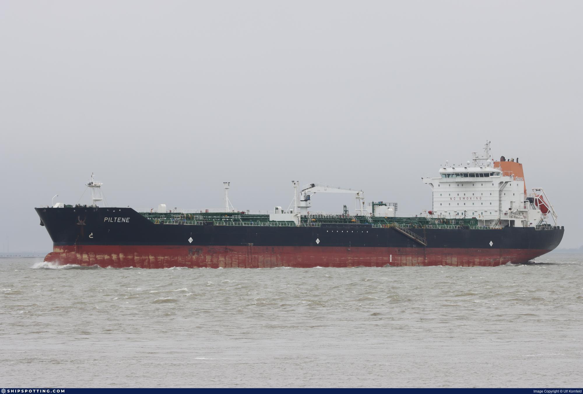
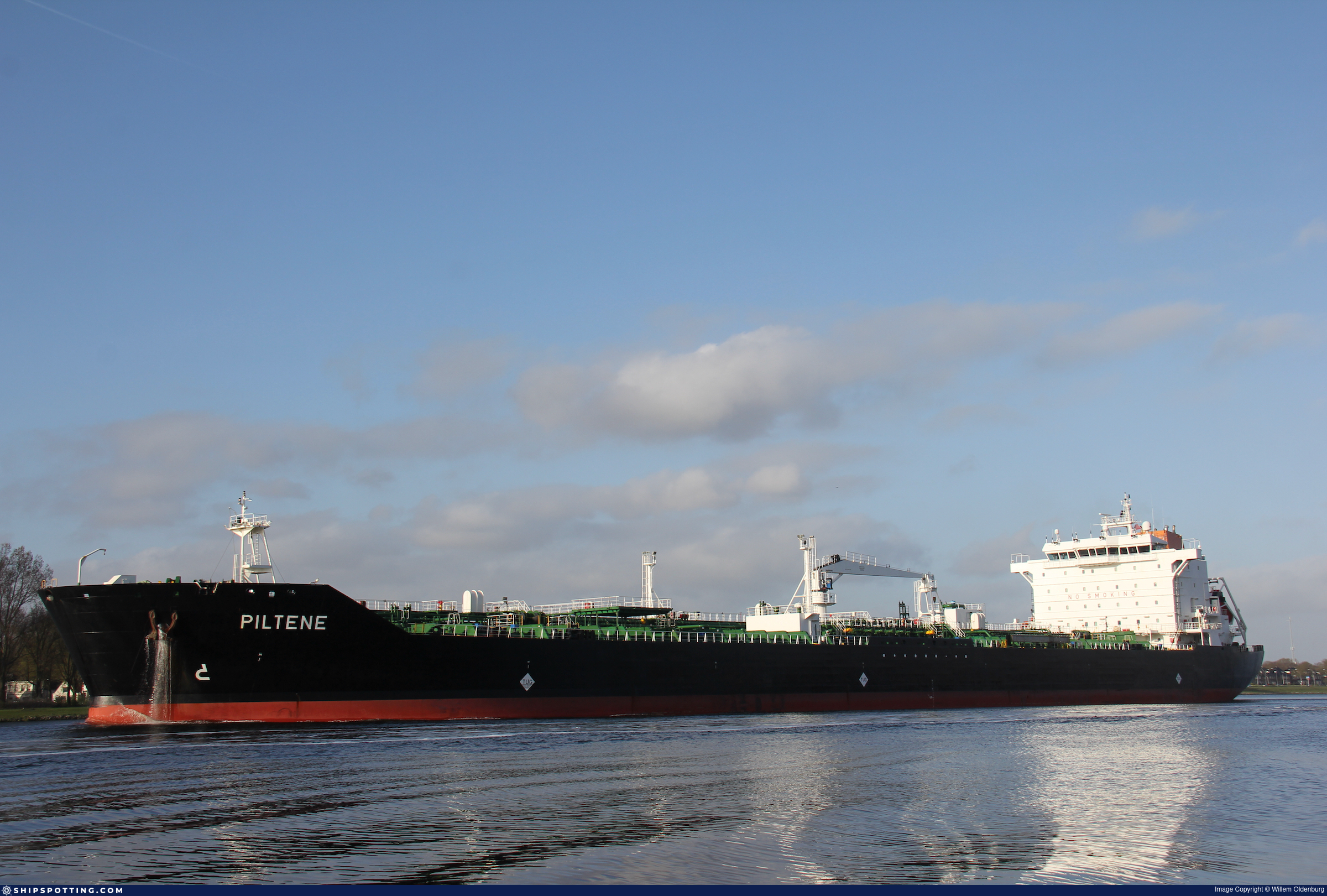
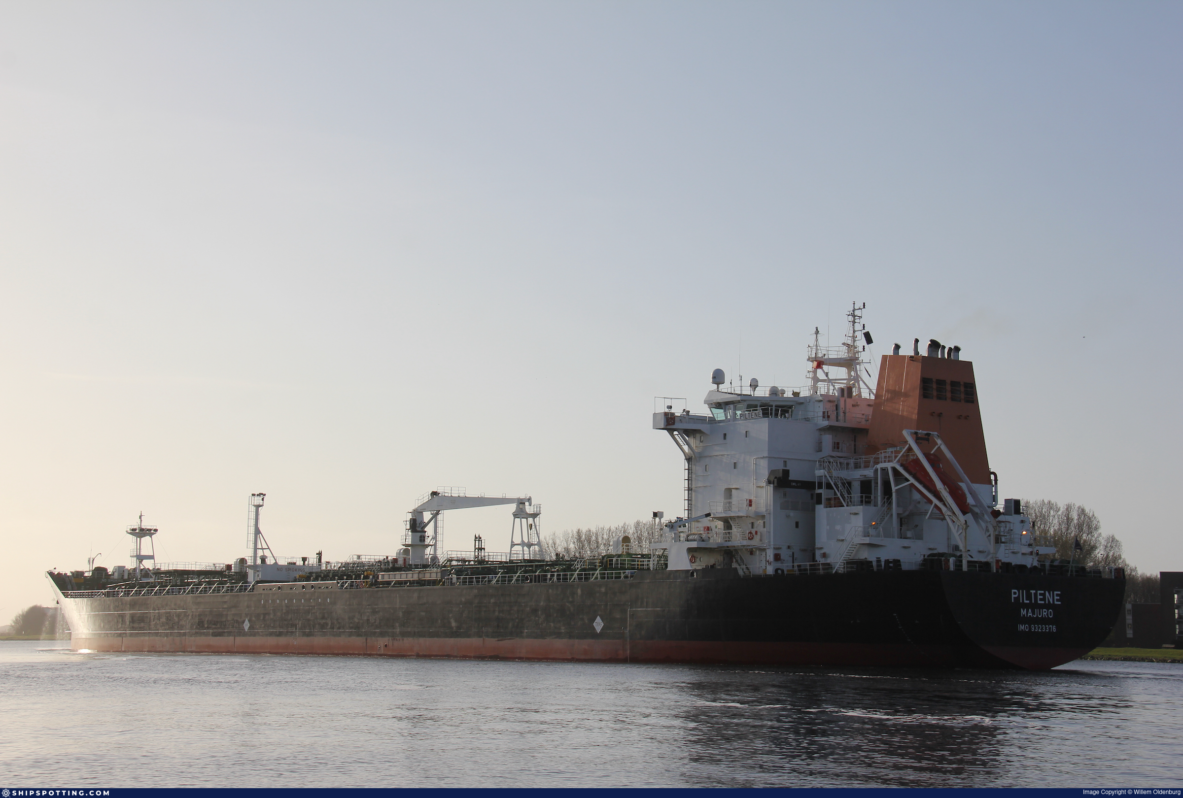
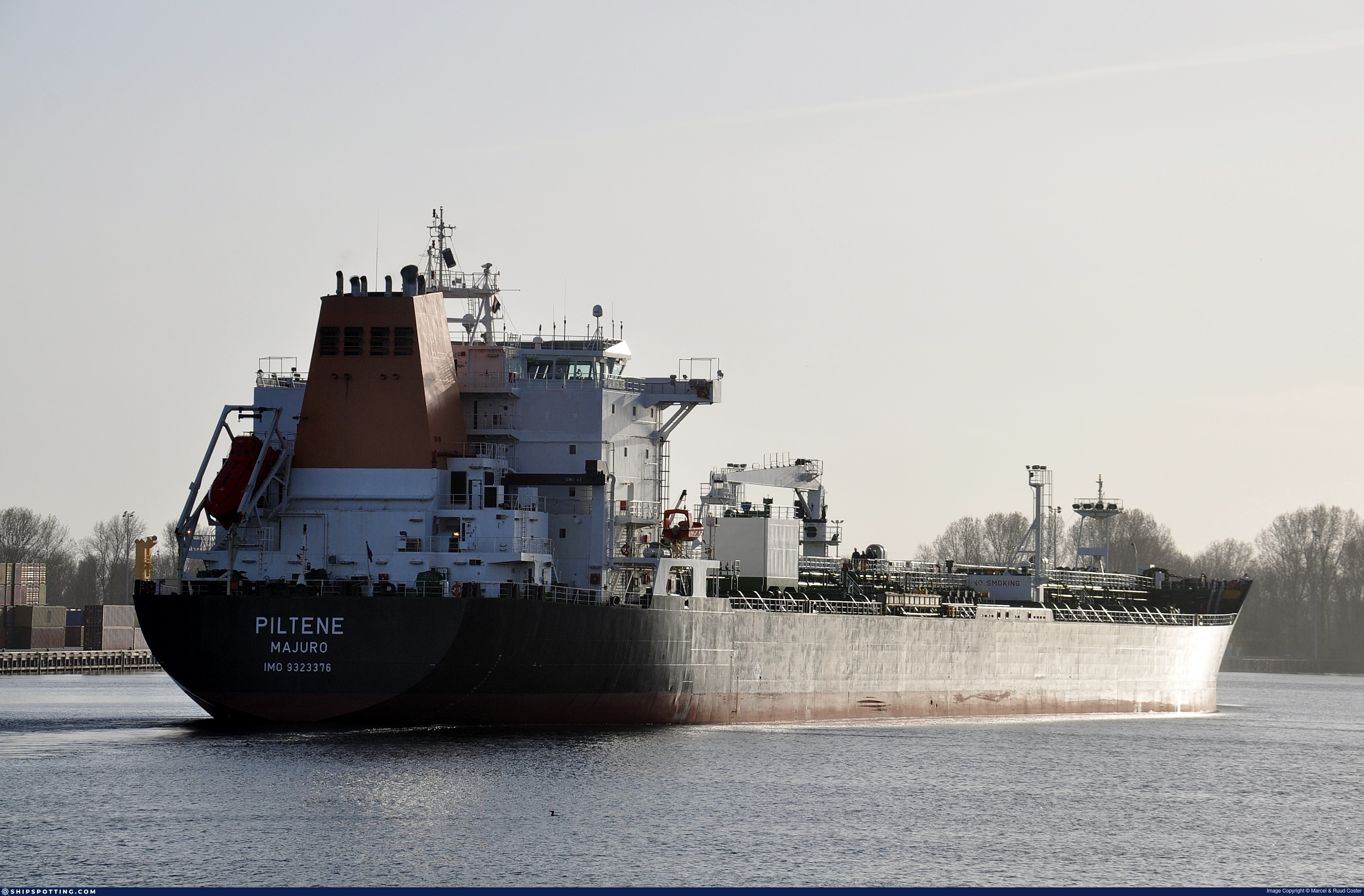
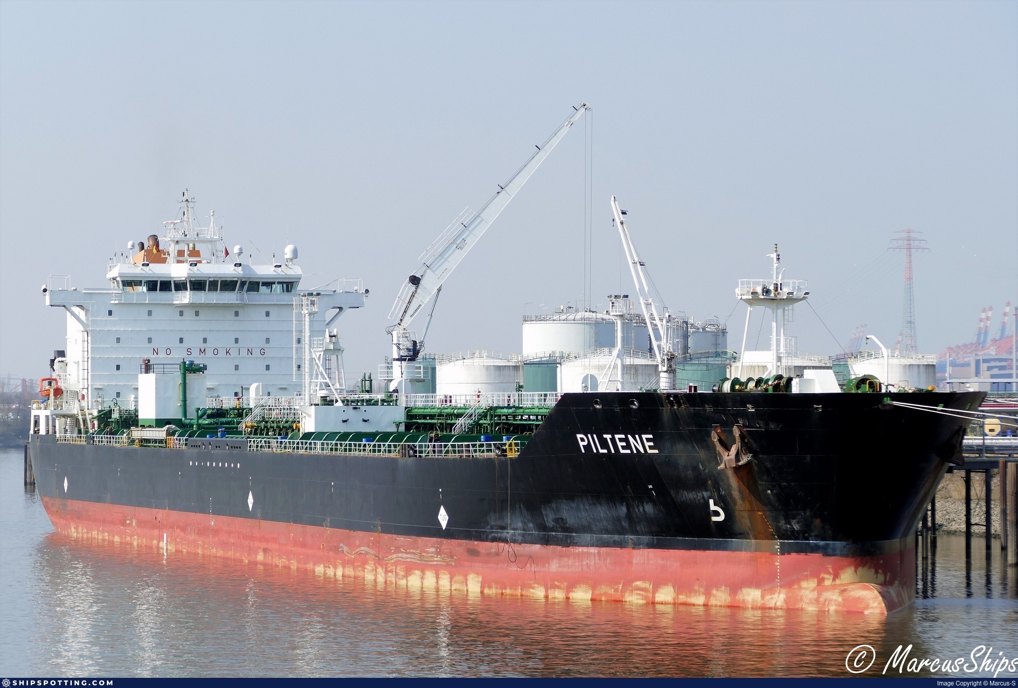
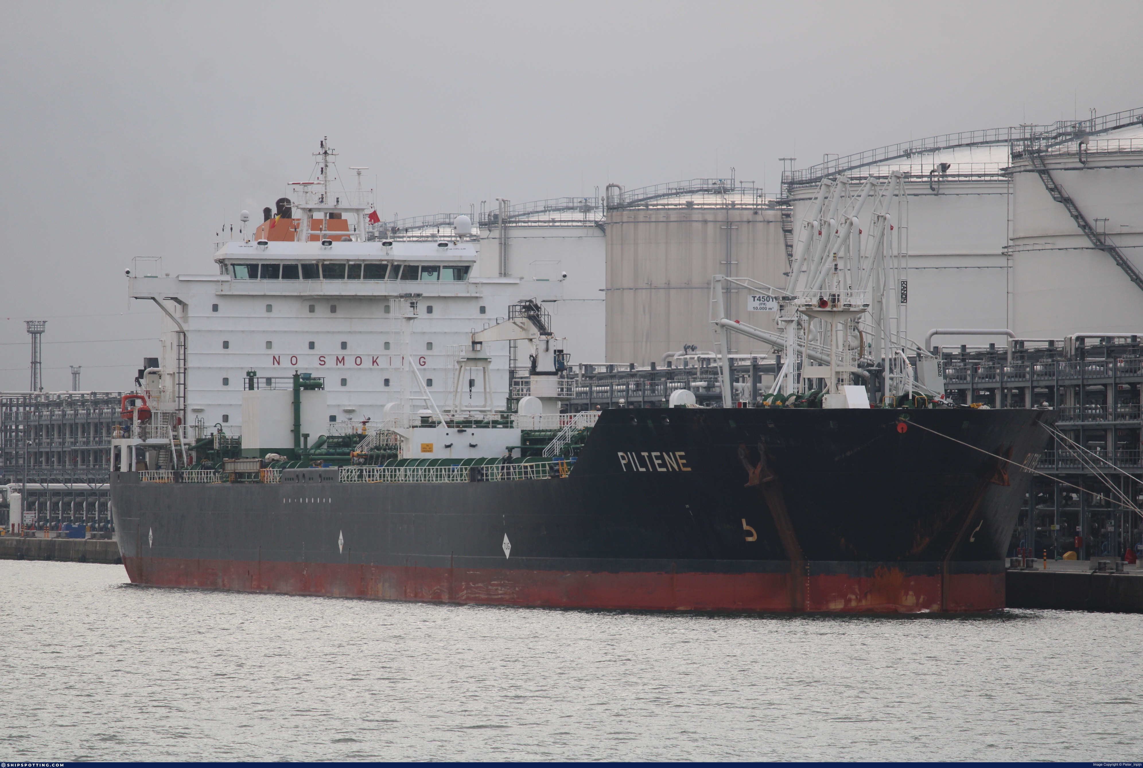
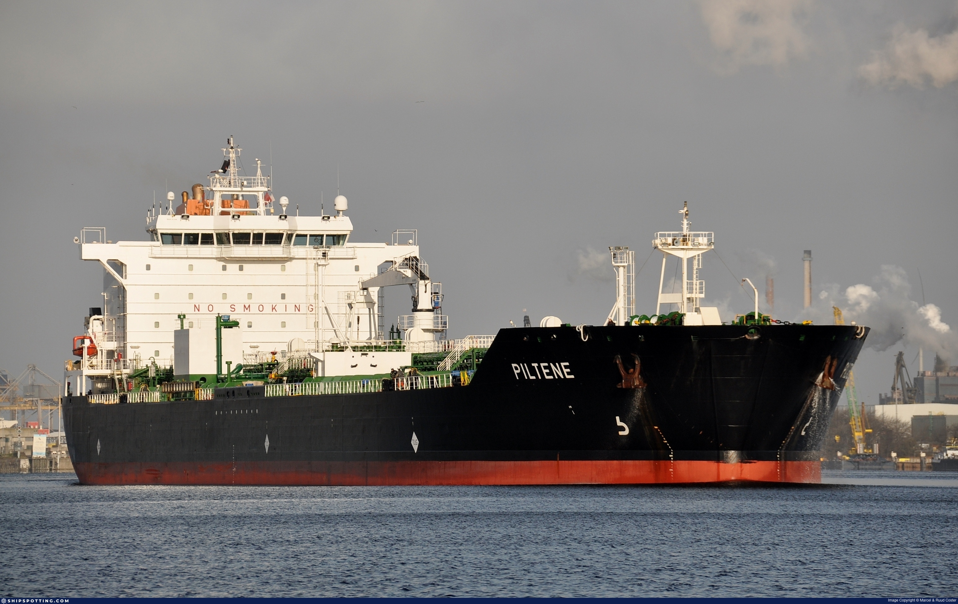
IMO 9323376
Vessel information
Sanctioned by
Company & Ownership
Management & Operations
Classification & Safety
Port State Control (PSC) Inspections
Survey Renewal & Certificates
| Code | Type | Issuer | Issued | Expires |
|---|---|---|---|---|
| 509 | Document of Compliance | Indian Register of Shipping (150) | 15/02/2024 | 30/01/2029 |
| 510 | Safety Management Certificate | Lloyd`s Register (160) | 05/02/2024 | 09/12/2028 |
Programs & Notes
EU Russia Sanctions – Shadow Fleet | AU vessel designations (DFAT) | SEMA (Canada) — vessel designations | The Russia (Sanctions) (EU Exit) Regulations 2019
DateOfListing: 2024-12-17 || DateDesignated: 2025-05-09 | Shipping sanctions: (see “Other information”) | Shipping sanctions: a specified ship is prohibited from being provided with access to or having its master or pilot cause it to enter a port in the UK, may have its registration on the UK Ship Register terminated, and a master or pilot of a specified ship may be given a port barring direction, a detention direction, and a port entry direction or a movement direction. | IMO 9323376 (“MARABELLA SUN”) is involved in activity whose object or effect is to destabilise Ukraine or undermine or threaten the territorial integrity, sovereignty or independence of Ukraine or to obtain a benefit from or support the Government of Russia. Namely, MARABELLA SUN is involved in carrying oil or oil products that originated in Russia from Russia to a third country.
Vessel Changes
 🔄 Owner
 🔄 Owner
 🏴 Flag
AIS Events
50 events detected • 2 zones • Last: Jul 18, 2026
- Zone: Eastern Mediterranean Surveillance Zone
- Duration: 3h 25m
- Data Points: 3 AIS positions
- Period: 2026-07-18T14:07:52+00:00 to 2026-07-18T17:33:29+00:00
Show Raw Evidence JSON
{
    "zone_id": "discovered_054",
    "zone_name": "Eastern Mediterranean Surveillance Zone",
    "dwell_minutes": 205.599999999999994315658113919198513031005859375,
    "points_in_zone": 3,
    "first_point": {
        "ts": "2026-07-18T14:07:52+00:00",
        "lat": 31.20224830000000082463884609751403331756591796875,
        "lon": 29.766553300000001769376467564143240451812744140625
    },
    "last_point": {
        "ts": "2026-07-18T17:33:29+00:00",
        "lat": 31.20216500000000081627149484120309352874755859375,
        "lon": 29.76630829999999861001924728043377399444580078125
    }
}- Zone: Eastern Mediterranean Surveillance Zone
- Duration: 1h 53m
- Data Points: 2 AIS positions
- Period: 2026-07-17T20:59:50+00:00 to 2026-07-17T22:53:03+00:00
Show Raw Evidence JSON
{
    "zone_id": "discovered_054",
    "zone_name": "Eastern Mediterranean Surveillance Zone",
    "dwell_minutes": 113.2000000000000028421709430404007434844970703125,
    "points_in_zone": 2,
    "first_point": {
        "ts": "2026-07-17T20:59:50+00:00",
        "lat": 31.20212169999999929359546513296663761138916015625,
        "lon": 29.766311699999999262900018948130309581756591796875
    },
    "last_point": {
        "ts": "2026-07-17T22:53:03+00:00",
        "lat": 31.202271700000000720365278539247810840606689453125,
        "lon": 29.766528300000000939462552196346223354339599609375
    }
}- Zone: Eastern Mediterranean Surveillance Zone
- Duration: 4h 46m
- Data Points: 2 AIS positions
- Period: 2026-07-11T18:17:32+00:00 to 2026-07-11T23:03:35+00:00
Show Raw Evidence JSON
{
    "zone_id": "discovered_054",
    "zone_name": "Eastern Mediterranean Surveillance Zone",
    "dwell_minutes": 286.1000000000000227373675443232059478759765625,
    "points_in_zone": 2,
    "first_point": {
        "ts": "2026-07-11T18:17:32+00:00",
        "lat": 31.202625000000001165290086646564304828643798828125,
        "lon": 29.76673170000000112622728920541703701019287109375
    },
    "last_point": {
        "ts": "2026-07-11T23:03:35+00:00",
        "lat": 31.20287330000000025620465748943388462066650390625,
        "lon": 29.7668867000000005873516784049570560455322265625
    }
}- Zone: Eastern Mediterranean Surveillance Zone
- Duration: 5h 3m
- Data Points: 3 AIS positions
- Period: 2026-07-11T17:59:40+00:00 to 2026-07-11T23:03:35+00:00
Show Raw Evidence JSON
{
    "zone_id": "discovered_054",
    "zone_name": "Eastern Mediterranean Surveillance Zone",
    "dwell_minutes": 303.8999999999999772626324556767940521240234375,
    "points_in_zone": 3,
    "first_point": {
        "ts": "2026-07-11T17:59:40+00:00",
        "lat": 31.202766700000001520720616099424660205841064453125,
        "lon": 29.766838299999999861711330595426261425018310546875
    },
    "last_point": {
        "ts": "2026-07-11T23:03:35+00:00",
        "lat": 31.20287330000000025620465748943388462066650390625,
        "lon": 29.7668867000000005873516784049570560455322265625
    }
}- Zone: Eastern Mediterranean Surveillance Zone
- Duration: 1h 59m
- Data Points: 3 AIS positions
- Period: 2026-07-11T16:18:20+00:00 to 2026-07-11T18:17:32+00:00
Show Raw Evidence JSON
{
    "zone_id": "discovered_054",
    "zone_name": "Eastern Mediterranean Surveillance Zone",
    "dwell_minutes": 119.2000000000000028421709430404007434844970703125,
    "points_in_zone": 3,
    "first_point": {
        "ts": "2026-07-11T16:18:20+00:00",
        "lat": 31.202726699999999482315615750849246978759765625,
        "lon": 29.766838299999999861711330595426261425018310546875
    },
    "last_point": {
        "ts": "2026-07-11T18:17:32+00:00",
        "lat": 31.202625000000001165290086646564304828643798828125,
        "lon": 29.76673170000000112622728920541703701019287109375
    }
}- Zone: Eastern Mediterranean Surveillance Zone
- Duration: 3h 46m
- Data Points: 4 AIS positions
- Period: 2026-07-11T14:31:03+00:00 to 2026-07-11T18:17:32+00:00
Show Raw Evidence JSON
{
    "zone_id": "discovered_054",
    "zone_name": "Eastern Mediterranean Surveillance Zone",
    "dwell_minutes": 226.5,
    "points_in_zone": 4,
    "first_point": {
        "ts": "2026-07-11T14:31:03+00:00",
        "lat": 31.202941700000000224690666073001921176910400390625,
        "lon": 29.7669716999999991458025760948657989501953125
    },
    "last_point": {
        "ts": "2026-07-11T18:17:32+00:00",
        "lat": 31.202625000000001165290086646564304828643798828125,
        "lon": 29.76673170000000112622728920541703701019287109375
    }
}- Zone: Eastern Mediterranean Surveillance Zone
- Duration: 2h 17m
- Data Points: 2 AIS positions
- Period: 2026-07-01T20:32:25+00:00 to 2026-07-01T22:49:31+00:00
Show Raw Evidence JSON
{
    "zone_id": "discovered_054",
    "zone_name": "Eastern Mediterranean Surveillance Zone",
    "dwell_minutes": 137.099999999999994315658113919198513031005859375,
    "points_in_zone": 2,
    "first_point": {
        "ts": "2026-07-01T20:32:25+00:00",
        "lat": 31.22868330000000014479155652225017547607421875,
        "lon": 29.74419329999999916935848887078464031219482421875
    },
    "last_point": {
        "ts": "2026-07-01T22:49:31+00:00",
        "lat": 31.2298483000000004494722816161811351776123046875,
        "lon": 29.744478300000000814407030702568590641021728515625
    }
}- Zone: Eastern Mediterranean Surveillance Zone
- Duration: 1h 23m
- Data Points: 2 AIS positions
- Period: 2026-07-01T11:03:18+00:00 to 2026-07-01T12:26:43+00:00
Show Raw Evidence JSON
{
    "zone_id": "discovered_054",
    "zone_name": "Eastern Mediterranean Surveillance Zone",
    "dwell_minutes": 83.400000000000005684341886080801486968994140625,
    "points_in_zone": 2,
    "first_point": {
        "ts": "2026-07-01T11:03:18+00:00",
        "lat": 31.228943300000000959926182986237108707427978515625,
        "lon": 29.744426700000001773105395841412246227264404296875
    },
    "last_point": {
        "ts": "2026-07-01T12:26:43+00:00",
        "lat": 31.228286700000001729904397507198154926300048828125,
        "lon": 29.743958299999999184137777774594724178314208984375
    }
}- Zone: Eastern Mediterranean Surveillance Zone
- Duration: 1h 41m
- Data Points: 3 AIS positions
- Period: 2026-07-01T10:45:26+00:00 to 2026-07-01T12:26:43+00:00
Show Raw Evidence JSON
{
    "zone_id": "discovered_054",
    "zone_name": "Eastern Mediterranean Surveillance Zone",
    "dwell_minutes": 101.2999999999999971578290569595992565155029296875,
    "points_in_zone": 3,
    "first_point": {
        "ts": "2026-07-01T10:45:26+00:00",
        "lat": 31.22906830000000155678208102472126483917236328125,
        "lon": 29.74452169999999995297912391833961009979248046875
    },
    "last_point": {
        "ts": "2026-07-01T12:26:43+00:00",
        "lat": 31.228286700000001729904397507198154926300048828125,
        "lon": 29.743958299999999184137777774594724178314208984375
    }
}- Zone: Eastern Mediterranean Surveillance Zone
- Duration: 5h 3m
- Data Points: 4 AIS positions
- Period: 2026-07-01T07:22:47+00:00 to 2026-07-01T12:26:43+00:00
Show Raw Evidence JSON
{
    "zone_id": "discovered_054",
    "zone_name": "Eastern Mediterranean Surveillance Zone",
    "dwell_minutes": 303.8999999999999772626324556767940521240234375,
    "points_in_zone": 4,
    "first_point": {
        "ts": "2026-07-01T07:22:47+00:00",
        "lat": 31.230058299999999604779077344574034214019775390625,
        "lon": 29.744495000000000572981662116944789886474609375
    },
    "last_point": {
        "ts": "2026-07-01T12:26:43+00:00",
        "lat": 31.228286700000001729904397507198154926300048828125,
        "lon": 29.743958299999999184137777774594724178314208984375
    }
}- Zone: Northwest Iberian Sea Surveillance Zone
- Duration: 1h 53m
- Data Points: 2 AIS positions
- Period: 2026-06-16T18:32:43+00:00 to 2026-06-16T20:25:56+00:00
Show Raw Evidence JSON
{
    "zone_id": "discovered_047",
    "zone_name": "Northwest Iberian Sea Surveillance Zone",
    "dwell_minutes": 113.2000000000000028421709430404007434844970703125,
    "points_in_zone": 2,
    "first_point": {
        "ts": "2026-06-16T18:32:43+00:00",
        "lat": 31.22982830000000120662662084214389324188232421875,
        "lon": 29.744273299999999693454810767434537410736083984375
    },
    "last_point": {
        "ts": "2026-06-16T20:25:56+00:00",
        "lat": 31.230868300000000914451447897590696811676025390625,
        "lon": 29.74317669999999935726009425707161426544189453125
    }
}- Zone: Northwest Iberian Sea Surveillance Zone
- Duration: 2h 15m
- Data Points: 6 AIS positions
- Period: 2026-06-11T18:00:20+00:00 to 2026-06-11T20:15:48+00:00
Show Raw Evidence JSON
{
    "zone_id": "discovered_047",
    "zone_name": "Northwest Iberian Sea Surveillance Zone",
    "dwell_minutes": 135.5,
    "points_in_zone": 6,
    "first_point": {
        "ts": "2026-06-11T18:00:20+00:00",
        "lat": 31.23708669999999898436726653017103672027587890625,
        "lon": 29.775163299999999111378201632760465145111083984375
    },
    "last_point": {
        "ts": "2026-06-11T20:15:48+00:00",
        "lat": 31.1983733000000000856744009070098400115966796875,
        "lon": 29.79635830000000140671545523218810558319091796875
    }
}- Zone: Northwest Iberian Sea Surveillance Zone
- Duration: 6h 21m
- Data Points: 7 AIS positions
- Period: 2026-06-11T13:54:13+00:00 to 2026-06-11T20:15:48+00:00
Show Raw Evidence JSON
{
    "zone_id": "discovered_047",
    "zone_name": "Northwest Iberian Sea Surveillance Zone",
    "dwell_minutes": 381.6000000000000227373675443232059478759765625,
    "points_in_zone": 7,
    "first_point": {
        "ts": "2026-06-11T13:54:13+00:00",
        "lat": 31.22867670000000117624949780292809009552001953125,
        "lon": 29.6704383000000007086782716214656829833984375
    },
    "last_point": {
        "ts": "2026-06-11T20:15:48+00:00",
        "lat": 31.1983733000000000856744009070098400115966796875,
        "lon": 29.79635830000000140671545523218810558319091796875
    }
}- Zone: Northwest Iberian Sea Surveillance Zone
- Duration: 1h 53m
- Data Points: 4 AIS positions
- Period: 2026-06-09T08:27:58+00:00 to 2026-06-09T10:21:12+00:00
Show Raw Evidence JSON
{
    "zone_id": "discovered_047",
    "zone_name": "Northwest Iberian Sea Surveillance Zone",
    "dwell_minutes": 113.2000000000000028421709430404007434844970703125,
    "points_in_zone": 4,
    "first_point": {
        "ts": "2026-06-09T08:27:58+00:00",
        "lat": 31.2295400000000000773070496506989002227783203125,
        "lon": 29.67064500000000037971403799019753932952880859375
    },
    "last_point": {
        "ts": "2026-06-09T10:21:12+00:00",
        "lat": 31.229531699999999005967765697278082370758056640625,
        "lon": 29.670688299999998349676388897933065891265869140625
    }
}- Zone: Northwest Iberian Sea Surveillance Zone
- Duration: 3h 52m
- Data Points: 5 AIS positions
- Period: 2026-06-09T06:28:46+00:00 to 2026-06-09T10:21:12+00:00
Show Raw Evidence JSON
{
    "zone_id": "discovered_047",
    "zone_name": "Northwest Iberian Sea Surveillance Zone",
    "dwell_minutes": 232.400000000000005684341886080801486968994140625,
    "points_in_zone": 5,
    "first_point": {
        "ts": "2026-06-09T06:28:46+00:00",
        "lat": 31.230508300000000332374838762916624546051025390625,
        "lon": 29.670448300000000330101102008484303951263427734375
    },
    "last_point": {
        "ts": "2026-06-09T10:21:12+00:00",
        "lat": 31.229531699999999005967765697278082370758056640625,
        "lon": 29.670688299999998349676388897933065891265869140625
    }
}- Zone: Northwest Iberian Sea Surveillance Zone
- Duration: 4h 49m
- Data Points: 6 AIS positions
- Period: 2026-06-09T05:32:09+00:00 to 2026-06-09T10:21:12+00:00
Show Raw Evidence JSON
{
    "zone_id": "discovered_047",
    "zone_name": "Northwest Iberian Sea Surveillance Zone",
    "dwell_minutes": 289.1000000000000227373675443232059478759765625,
    "points_in_zone": 6,
    "first_point": {
        "ts": "2026-06-09T05:32:09+00:00",
        "lat": 31.230968300000000681393430568277835845947265625,
        "lon": 29.670093300000001335092747467570006847381591796875
    },
    "last_point": {
        "ts": "2026-06-09T10:21:12+00:00",
        "lat": 31.229531699999999005967765697278082370758056640625,
        "lon": 29.670688299999998349676388897933065891265869140625
    }
}- Zone: Northwest Iberian Sea Surveillance Zone
- Duration: 6h 15m
- Data Points: 7 AIS positions
- Period: 2026-06-09T04:05:42+00:00 to 2026-06-09T10:21:12+00:00
Show Raw Evidence JSON
{
    "zone_id": "discovered_047",
    "zone_name": "Northwest Iberian Sea Surveillance Zone",
    "dwell_minutes": 375.5,
    "points_in_zone": 7,
    "first_point": {
        "ts": "2026-06-09T04:05:42+00:00",
        "lat": 31.231365000000000264890331891365349292755126953125,
        "lon": 29.669554999999999012061380199156701564788818359375
    },
    "last_point": {
        "ts": "2026-06-09T10:21:12+00:00",
        "lat": 31.229531699999999005967765697278082370758056640625,
        "lon": 29.670688299999998349676388897933065891265869140625
    }
}- Zone: Northwest Iberian Sea Surveillance Zone
- Duration: 5h 57m
- Data Points: 7 AIS positions
- Period: 2026-06-09T02:39:20+00:00 to 2026-06-09T08:36:53+00:00
Show Raw Evidence JSON
{
    "zone_id": "discovered_047",
    "zone_name": "Northwest Iberian Sea Surveillance Zone",
    "dwell_minutes": 357.6000000000000227373675443232059478759765625,
    "points_in_zone": 7,
    "first_point": {
        "ts": "2026-06-09T02:39:20+00:00",
        "lat": 31.23136170000000078061930253170430660247802734375,
        "lon": 29.6693767000000008238203008659183979034423828125
    },
    "last_point": {
        "ts": "2026-06-09T08:36:53+00:00",
        "lat": 31.229665000000000674162947689183056354522705078125,
        "lon": 29.67060169999999885703800828196108341217041015625
    }
}- Zone: Northwest Iberian Sea Surveillance Zone
- Duration: 1h 26m
- Data Points: 3 AIS positions
- Period: 2026-06-08T17:04:13+00:00 to 2026-06-08T18:30:42+00:00
Show Raw Evidence JSON
{
    "zone_id": "discovered_047",
    "zone_name": "Northwest Iberian Sea Surveillance Zone",
    "dwell_minutes": 86.5,
    "points_in_zone": 3,
    "first_point": {
        "ts": "2026-06-08T17:04:13+00:00",
        "lat": 31.2279300000000006320988177321851253509521484375,
        "lon": 29.66912500000000108002495835535228252410888671875
    },
    "last_point": {
        "ts": "2026-06-08T18:30:42+00:00",
        "lat": 31.22794499999999828787622391246259212493896484375,
        "lon": 29.668375000000001051603248924948275089263916015625
    }
}- Zone: Northwest Iberian Sea Surveillance Zone
- Duration: 2h 29m
- Data Points: 8 AIS positions
- Period: 2026-06-08T16:01:39+00:00 to 2026-06-08T18:30:42+00:00
Show Raw Evidence JSON
{
    "zone_id": "discovered_047",
    "zone_name": "Northwest Iberian Sea Surveillance Zone",
    "dwell_minutes": 149.099999999999994315658113919198513031005859375,
    "points_in_zone": 8,
    "first_point": {
        "ts": "2026-06-08T16:01:39+00:00",
        "lat": 31.22809000000000168029146152548491954803466796875,
        "lon": 29.6696333000000009860741556622087955474853515625
    },
    "last_point": {
        "ts": "2026-06-08T18:30:42+00:00",
        "lat": 31.22794499999999828787622391246259212493896484375,
        "lon": 29.668375000000001051603248924948275089263916015625
    }
}- Duration: 2h 41m
- Radius: 91 meters
- Data Points: 10 AIS positions
- Centroid: 31.2280, 29.6693
- Zone: Northwest Iberian Sea Surveillance Zone
Show Raw Evidence JSON
{
    "radius_m": 90.7999999999999971578290569595992565155029296875,
    "duration_minutes": 161,
    "points": 10,
    "centroid": {
        "lat": 31.22801865999999648693119524978101253509521484375,
        "lon": 29.66932399000000231126250582747161388397216796875
    },
    "bbox": {
        "min_lat": 31.22791000000000138925315695814788341522216796875,
        "min_lon": 29.668375000000001051603248924948275089263916015625,
        "max_lat": 31.228211699999999240162651403807103633880615234375,
        "max_lon": 29.66975000000000051159076974727213382720947265625
    },
    "zone_id": "discovered_047"
}- Zone: Northwest Iberian Sea Surveillance Zone
- Duration: 2h 41m
- Data Points: 10 AIS positions
- Period: 2026-06-08T15:49:42+00:00 to 2026-06-08T18:30:42+00:00
Show Raw Evidence JSON
{
    "zone_id": "discovered_047",
    "zone_name": "Northwest Iberian Sea Surveillance Zone",
    "dwell_minutes": 161,
    "points_in_zone": 10,
    "first_point": {
        "ts": "2026-06-08T15:49:42+00:00",
        "lat": 31.228211699999999240162651403807103633880615234375,
        "lon": 29.66975000000000051159076974727213382720947265625
    },
    "last_point": {
        "ts": "2026-06-08T18:30:42+00:00",
        "lat": 31.22794499999999828787622391246259212493896484375,
        "lon": 29.668375000000001051603248924948275089263916015625
    }
}- Zone: Northwest Iberian Sea Surveillance Zone
- Duration: 1h 17m
- Data Points: 7 AIS positions
- Period: 2026-06-05T15:01:21+00:00 to 2026-06-05T16:18:47+00:00
Show Raw Evidence JSON
{
    "zone_id": "discovered_047",
    "zone_name": "Northwest Iberian Sea Surveillance Zone",
    "dwell_minutes": 77.400000000000005684341886080801486968994140625,
    "points_in_zone": 7,
    "first_point": {
        "ts": "2026-06-05T15:01:21+00:00",
        "lat": 31.22827829999999948995537124574184417724609375,
        "lon": 29.668890000000001094804247259162366390228271484375
    },
    "last_point": {
        "ts": "2026-06-05T16:18:47+00:00",
        "lat": 31.22825999999999879719325690530240535736083984375,
        "lon": 29.668626700000000795398591435514390468597412109375
    }
}- Duration: 2h 14m
- Radius: 29 meters
- Data Points: 13 AIS positions
- Centroid: 31.2283, 29.6689
- Zone: Northwest Iberian Sea Surveillance Zone
Show Raw Evidence JSON
{
    "radius_m": 28.60000000000000142108547152020037174224853515625,
    "duration_minutes": 134.099999999999994315658113919198513031005859375,
    "points": 13,
    "centroid": {
        "lat": 31.2282951230769185713143087923526763916015625,
        "lon": 29.66886692307692641179528436623513698577880859375
    },
    "bbox": {
        "min_lat": 31.22818170000000037589416024275124073028564453125,
        "min_lon": 29.66858500000000020691004465334117412567138671875,
        "max_lat": 31.228381699999999909778125584125518798828125,
        "max_lon": 29.6690933000000001129592419601976871490478515625
    },
    "zone_id": "discovered_047"
}- Zone: Northwest Iberian Sea Surveillance Zone
- Duration: 2h 14m
- Data Points: 13 AIS positions
- Period: 2026-06-05T14:04:43+00:00 to 2026-06-05T16:18:47+00:00
Show Raw Evidence JSON
{
    "zone_id": "discovered_047",
    "zone_name": "Northwest Iberian Sea Surveillance Zone",
    "dwell_minutes": 134.099999999999994315658113919198513031005859375,
    "points_in_zone": 13,
    "first_point": {
        "ts": "2026-06-05T14:04:43+00:00",
        "lat": 31.228381699999999909778125584125518798828125,
        "lon": 29.6690882999999985258909873664379119873046875
    },
    "last_point": {
        "ts": "2026-06-05T16:18:47+00:00",
        "lat": 31.22825999999999879719325690530240535736083984375,
        "lon": 29.668626700000000795398591435514390468597412109375
    }
}- Duration: 3h 13m
- Radius: 36 meters
- Data Points: 19 AIS positions
- Centroid: 31.2283, 29.6689
- Zone: Northwest Iberian Sea Surveillance Zone
Show Raw Evidence JSON
{
    "radius_m": 35.60000000000000142108547152020037174224853515625,
    "duration_minutes": 193.69999999999998863131622783839702606201171875,
    "points": 19,
    "centroid": {
        "lat": 31.2282955210526296241368982009589672088623046875,
        "lon": 29.668944384210522713374302838928997516632080078125
    },
    "bbox": {
        "min_lat": 31.22818170000000037589416024275124073028564453125,
        "min_lon": 29.66858500000000020691004465334117412567138671875,
        "max_lat": 31.22838829999999887832018430344760417938232421875,
        "max_lon": 29.66923669999999901847331784665584564208984375
    },
    "zone_id": "discovered_047"
}- Zone: Northwest Iberian Sea Surveillance Zone
- Duration: 3h 13m
- Data Points: 19 AIS positions
- Period: 2026-06-05T13:05:08+00:00 to 2026-06-05T16:18:47+00:00
Show Raw Evidence JSON
{
    "zone_id": "discovered_047",
    "zone_name": "Northwest Iberian Sea Surveillance Zone",
    "dwell_minutes": 193.69999999999998863131622783839702606201171875,
    "points_in_zone": 19,
    "first_point": {
        "ts": "2026-06-05T13:05:08+00:00",
        "lat": 31.22838829999999887832018430344760417938232421875,
        "lon": 29.66923669999999901847331784665584564208984375
    },
    "last_point": {
        "ts": "2026-06-05T16:18:47+00:00",
        "lat": 31.22825999999999879719325690530240535736083984375,
        "lon": 29.668626700000000795398591435514390468597412109375
    }
}- Duration: 3h 31m
- Radius: 40 meters
- Data Points: 21 AIS positions
- Centroid: 31.2283, 29.6690
- Zone: Northwest Iberian Sea Surveillance Zone
Show Raw Evidence JSON
{
    "radius_m": 39.60000000000000142108547152020037174224853515625,
    "duration_minutes": 211.5,
    "points": 21,
    "centroid": {
        "lat": 31.228309600000006440723154810257256031036376953125,
        "lon": 29.668976190476190168965331395156681537628173828125
    },
    "bbox": {
        "min_lat": 31.22818170000000037589416024275124073028564453125,
        "min_lon": 29.66858500000000020691004465334117412567138671875,
        "max_lat": 31.22849000000000074805939220823347568511962890625,
        "max_lon": 29.669335000000000235331754083745181560516357421875
    },
    "zone_id": "discovered_047"
}- Zone: Northwest Iberian Sea Surveillance Zone
- Duration: 3h 31m
- Data Points: 21 AIS positions
- Period: 2026-06-05T12:47:15+00:00 to 2026-06-05T16:18:47+00:00
Show Raw Evidence JSON
{
    "zone_id": "discovered_047",
    "zone_name": "Northwest Iberian Sea Surveillance Zone",
    "dwell_minutes": 211.5,
    "points_in_zone": 21,
    "first_point": {
        "ts": "2026-06-05T12:47:15+00:00",
        "lat": 31.22849000000000074805939220823347568511962890625,
        "lon": 29.669335000000000235331754083745181560516357421875
    },
    "last_point": {
        "ts": "2026-06-05T16:18:47+00:00",
        "lat": 31.22825999999999879719325690530240535736083984375,
        "lon": 29.668626700000000795398591435514390468597412109375
    }
}- Zone: Northwest Iberian Sea Surveillance Zone
- Duration: 1h 20m
- Data Points: 7 AIS positions
- Period: 2026-06-04T15:05:10+00:00 to 2026-06-04T16:25:30+00:00
Show Raw Evidence JSON
{
    "zone_id": "discovered_047",
    "zone_name": "Northwest Iberian Sea Surveillance Zone",
    "dwell_minutes": 80.2999999999999971578290569595992565155029296875,
    "points_in_zone": 7,
    "first_point": {
        "ts": "2026-06-04T15:05:10+00:00",
        "lat": 31.2278333000000003494278644211590290069580078125,
        "lon": 29.66671170000000046229615691117942333221435546875
    },
    "last_point": {
        "ts": "2026-06-04T16:25:30+00:00",
        "lat": 31.227753299999999825331542524509131908416748046875,
        "lon": 29.66685830000000123618519864976406097412109375
    }
}- Duration: 1h 41m
- Radius: 27 meters
- Data Points: 10 AIS positions
- Centroid: 31.2278, 29.6667
- Zone: Northwest Iberian Sea Surveillance Zone
Show Raw Evidence JSON
{
    "radius_m": 27.300000000000000710542735760100185871124267578125,
    "duration_minutes": 101.2999999999999971578290569595992565155029296875,
    "points": 10,
    "centroid": {
        "lat": 31.22782699000000405931132263503968715667724609375,
        "lon": 29.666657330000003156555976602248847484588623046875
    },
    "bbox": {
        "min_lat": 31.227753299999999825331542524509131908416748046875,
        "min_lon": 29.66638999999999981582732289098203182220458984375,
        "max_lat": 31.227914999999999423607732751406729221343994140625,
        "max_lon": 29.66685830000000123618519864976406097412109375
    },
    "zone_id": "discovered_047"
}- Zone: Northwest Iberian Sea Surveillance Zone
- Duration: 1h 41m
- Data Points: 10 AIS positions
- Period: 2026-06-04T14:44:11+00:00 to 2026-06-04T16:25:30+00:00
Show Raw Evidence JSON
{
    "zone_id": "discovered_047",
    "zone_name": "Northwest Iberian Sea Surveillance Zone",
    "dwell_minutes": 101.2999999999999971578290569595992565155029296875,
    "points_in_zone": 10,
    "first_point": {
        "ts": "2026-06-04T14:44:11+00:00",
        "lat": 31.22785329999999959227352519519627094268798828125,
        "lon": 29.6666282999999992853190633468329906463623046875
    },
    "last_point": {
        "ts": "2026-06-04T16:25:30+00:00",
        "lat": 31.227753299999999825331542524509131908416748046875,
        "lon": 29.66685830000000123618519864976406097412109375
    }
}- Duration: 2h 55m
- Radius: 67 meters
- Data Points: 15 AIS positions
- Centroid: 31.2278, 29.6669
- Zone: Northwest Iberian Sea Surveillance Zone
Show Raw Evidence JSON
{
    "radius_m": 67.2000000000000028421709430404007434844970703125,
    "duration_minutes": 175.80000000000001136868377216160297393798828125,
    "points": 15,
    "centroid": {
        "lat": 31.227841546666670780041386024095118045806884765625,
        "lon": 29.66688666666666307492050691507756710052490234375
    },
    "bbox": {
        "min_lat": 31.227753299999999825331542524509131908416748046875,
        "min_lon": 29.66638999999999981582732289098203182220458984375,
        "max_lat": 31.227914999999999423607732751406729221343994140625,
        "max_lon": 29.667591699999999121928340173326432704925537109375
    },
    "zone_id": "discovered_047"
}- Zone: Northwest Iberian Sea Surveillance Zone
- Duration: 2h 55m
- Data Points: 15 AIS positions
- Period: 2026-06-04T13:29:43+00:00 to 2026-06-04T16:25:30+00:00
Show Raw Evidence JSON
{
    "zone_id": "discovered_047",
    "zone_name": "Northwest Iberian Sea Surveillance Zone",
    "dwell_minutes": 175.80000000000001136868377216160297393798828125,
    "points_in_zone": 15,
    "first_point": {
        "ts": "2026-06-04T13:29:43+00:00",
        "lat": 31.22785329999999959227352519519627094268798828125,
        "lon": 29.667591699999999121928340173326432704925537109375
    },
    "last_point": {
        "ts": "2026-06-04T16:25:30+00:00",
        "lat": 31.227753299999999825331542524509131908416748046875,
        "lon": 29.66685830000000123618519864976406097412109375
    }
}- Zone: Northwest Iberian Sea Surveillance Zone
- Duration: 1h 29m
- Data Points: 8 AIS positions
- Period: 2026-06-03T14:39:00+00:00 to 2026-06-03T16:08:25+00:00
Show Raw Evidence JSON
{
    "zone_id": "discovered_047",
    "zone_name": "Northwest Iberian Sea Surveillance Zone",
    "dwell_minutes": 89.400000000000005684341886080801486968994140625,
    "points_in_zone": 8,
    "first_point": {
        "ts": "2026-06-03T14:39:00+00:00",
        "lat": 31.227664999999998229895936674438416957855224609375,
        "lon": 29.66673829999999867368387640453875064849853515625
    },
    "last_point": {
        "ts": "2026-06-03T16:08:25+00:00",
        "lat": 31.2284149999999982583176461048424243927001953125,
        "lon": 29.66546170000000159916453412733972072601318359375
    }
}- Duration: 2h 58m
- Radius: 134 meters
- Data Points: 12 AIS positions
- Centroid: 31.2279, 29.6667
- Zone: Northwest Iberian Sea Surveillance Zone
Show Raw Evidence JSON
{
    "radius_m": 134.30000000000001136868377216160297393798828125,
    "duration_minutes": 178.80000000000001136868377216160297393798828125,
    "points": 12,
    "centroid": {
        "lat": 31.227913891666663204205178772099316120147705078125,
        "lon": 29.666745408333330402683714055456221103668212890625
    },
    "bbox": {
        "min_lat": 31.227664999999998229895936674438416957855224609375,
        "min_lon": 29.66546170000000159916453412733972072601318359375,
        "max_lat": 31.2284149999999982583176461048424243927001953125,
        "max_lon": 29.66814000000000106638253782875835895538330078125
    },
    "zone_id": "discovered_047"
}- Zone: Northwest Iberian Sea Surveillance Zone
- Duration: 2h 58m
- Data Points: 12 AIS positions
- Period: 2026-06-03T13:09:37+00:00 to 2026-06-03T16:08:25+00:00
Show Raw Evidence JSON
{
    "zone_id": "discovered_047",
    "zone_name": "Northwest Iberian Sea Surveillance Zone",
    "dwell_minutes": 178.80000000000001136868377216160297393798828125,
    "points_in_zone": 12,
    "first_point": {
        "ts": "2026-06-03T13:09:37+00:00",
        "lat": 31.227978300000000189129423233680427074432373046875,
        "lon": 29.66814000000000106638253782875835895538330078125
    },
    "last_point": {
        "ts": "2026-06-03T16:08:25+00:00",
        "lat": 31.2284149999999982583176461048424243927001953125,
        "lon": 29.66546170000000159916453412733972072601318359375
    }
}- Duration: 3h 28m
- Radius: 181 meters
- Data Points: 13 AIS positions
- Centroid: 31.2280, 29.6669
- Zone: Northwest Iberian Sea Surveillance Zone
Show Raw Evidence JSON
{
    "radius_m": 180.599999999999994315658113919198513031005859375,
    "duration_minutes": 208.599999999999994315658113919198513031005859375,
    "points": 13,
    "centroid": {
        "lat": 31.22795051538461308382466086186468601226806640625,
        "lon": 29.666897553846158785972875193692743778228759765625
    },
    "bbox": {
        "min_lat": 31.227664999999998229895936674438416957855224609375,
        "min_lon": 29.66546170000000159916453412733972072601318359375,
        "max_lat": 31.2284149999999982583176461048424243927001953125,
        "max_lon": 29.668723299999999909459802438504993915557861328125
    },
    "zone_id": "discovered_047"
}- Zone: Northwest Iberian Sea Surveillance Zone
- Duration: 3h 28m
- Data Points: 13 AIS positions
- Period: 2026-06-03T12:39:48+00:00 to 2026-06-03T16:08:25+00:00
Show Raw Evidence JSON
{
    "zone_id": "discovered_047",
    "zone_name": "Northwest Iberian Sea Surveillance Zone",
    "dwell_minutes": 208.599999999999994315658113919198513031005859375,
    "points_in_zone": 13,
    "first_point": {
        "ts": "2026-06-03T12:39:48+00:00",
        "lat": 31.228390000000000981117409537546336650848388671875,
        "lon": 29.668723299999999909459802438504993915557861328125
    },
    "last_point": {
        "ts": "2026-06-03T16:08:25+00:00",
        "lat": 31.2284149999999982583176461048424243927001953125,
        "lon": 29.66546170000000159916453412733972072601318359375
    }
}- Zone: Northwest Iberian Sea Surveillance Zone
- Duration: 5h 57m
- Data Points: 6 AIS positions
- Period: 2026-06-03T07:59:43+00:00 to 2026-06-03T13:57:17+00:00
Show Raw Evidence JSON
{
    "zone_id": "discovered_047",
    "zone_name": "Northwest Iberian Sea Surveillance Zone",
    "dwell_minutes": 357.6000000000000227373675443232059478759765625,
    "points_in_zone": 6,
    "first_point": {
        "ts": "2026-06-03T07:59:43+00:00",
        "lat": 31.230743300000000317595549859106540679931640625,
        "lon": 29.66966169999999891615516389720141887664794921875
    },
    "last_point": {
        "ts": "2026-06-03T13:57:17+00:00",
        "lat": 31.2278850000000005593392415903508663177490234375,
        "lon": 29.667500000000000426325641456060111522674560546875
    }
}- Zone: Northwest Iberian Sea Surveillance Zone
- Duration: 2h 14m
- Data Points: 5 AIS positions
- Period: 2026-06-02T17:05:46+00:00 to 2026-06-02T19:19:51+00:00
Show Raw Evidence JSON
{
    "zone_id": "discovered_047",
    "zone_name": "Northwest Iberian Sea Surveillance Zone",
    "dwell_minutes": 134.099999999999994315658113919198513031005859375,
    "points_in_zone": 5,
    "first_point": {
        "ts": "2026-06-02T17:05:46+00:00",
        "lat": 31.2290516999999994141035131178796291351318359375,
        "lon": 29.665041699999999735837263870052993297576904296875
    },
    "last_point": {
        "ts": "2026-06-02T19:19:51+00:00",
        "lat": 31.229856699999999136707629077136516571044921875,
        "lon": 29.664911700000001104626790038309991359710693359375
    }
}- Zone: Northwest Iberian Sea Surveillance Zone
- Duration: 3h 52m
- Data Points: 6 AIS positions
- Period: 2026-06-02T15:27:27+00:00 to 2026-06-02T19:19:51+00:00
Show Raw Evidence JSON
{
    "zone_id": "discovered_047",
    "zone_name": "Northwest Iberian Sea Surveillance Zone",
    "dwell_minutes": 232.400000000000005684341886080801486968994140625,
    "points_in_zone": 6,
    "first_point": {
        "ts": "2026-06-02T15:27:27+00:00",
        "lat": 31.228194999999999481588019989430904388427734375,
        "lon": 29.667403300000000143654688145034015178680419921875
    },
    "last_point": {
        "ts": "2026-06-02T19:19:51+00:00",
        "lat": 31.229856699999999136707629077136516571044921875,
        "lon": 29.664911700000001104626790038309991359710693359375
    }
}- Duration: 5h 9m
- Radius: 251 meters
- Data Points: 12 AIS positions
- Centroid: 31.2294, 29.6674
- Zone: Northwest Iberian Sea Surveillance Zone
Show Raw Evidence JSON
{
    "radius_m": 251,
    "duration_minutes": 309.8999999999999772626324556767940521240234375,
    "points": 12,
    "centroid": {
        "lat": 31.229426674999995583448253455571830272674560546875,
        "lon": 29.66737472500000194486347027122974395751953125
    },
    "bbox": {
        "min_lat": 31.228194999999999481588019989430904388427734375,
        "min_lon": 29.664911700000001104626790038309991359710693359375,
        "max_lat": 31.2301183000000008860297384671866893768310546875,
        "max_lon": 29.669883299999998627072272938676178455352783203125
    },
    "zone_id": "discovered_047"
}- Zone: Northwest Iberian Sea Surveillance Zone
- Duration: 5h 9m
- Data Points: 12 AIS positions
- Period: 2026-06-02T14:09:58+00:00 to 2026-06-02T19:19:51+00:00
Show Raw Evidence JSON
{
    "zone_id": "discovered_047",
    "zone_name": "Northwest Iberian Sea Surveillance Zone",
    "dwell_minutes": 309.8999999999999772626324556767940521240234375,
    "points_in_zone": 12,
    "first_point": {
        "ts": "2026-06-02T14:09:58+00:00",
        "lat": 31.2301183000000008860297384671866893768310546875,
        "lon": 29.669883299999998627072272938676178455352783203125
    },
    "last_point": {
        "ts": "2026-06-02T19:19:51+00:00",
        "lat": 31.229856699999999136707629077136516571044921875,
        "lon": 29.664911700000001104626790038309991359710693359375
    }
}- Duration: 5h 36m
- Radius: 287 meters
- Data Points: 15 AIS positions
- Centroid: 31.2296, 29.6679
- Zone: Northwest Iberian Sea Surveillance Zone
Show Raw Evidence JSON
{
    "radius_m": 287.1000000000000227373675443232059478759765625,
    "duration_minutes": 336.69999999999998863131622783839702606201171875,
    "points": 15,
    "centroid": {
        "lat": 31.22963078666666802973850280977785587310791015625,
        "lon": 29.667913113333330699106227257288992404937744140625
    },
    "bbox": {
        "min_lat": 31.228194999999999481588019989430904388427734375,
        "min_lon": 29.664911700000001104626790038309991359710693359375,
        "max_lat": 31.230621700000000373620423488318920135498046875,
        "max_lon": 29.670210000000000860609361552633345127105712890625
    },
    "zone_id": "discovered_047"
}- Zone: Northwest Iberian Sea Surveillance Zone
- Duration: 5h 36m
- Data Points: 15 AIS positions
- Period: 2026-06-02T13:43:10+00:00 to 2026-06-02T19:19:51+00:00
Show Raw Evidence JSON
{
    "zone_id": "discovered_047",
    "zone_name": "Northwest Iberian Sea Surveillance Zone",
    "dwell_minutes": 336.69999999999998863131622783839702606201171875,
    "points_in_zone": 15,
    "first_point": {
        "ts": "2026-06-02T13:43:10+00:00",
        "lat": 31.230621700000000373620423488318920135498046875,
        "lon": 29.670210000000000860609361552633345127105712890625
    },
    "last_point": {
        "ts": "2026-06-02T19:19:51+00:00",
        "lat": 31.229856699999999136707629077136516571044921875,
        "lon": 29.664911700000001104626790038309991359710693359375
    }
}- Duration: 5h 6m
- Radius: 279 meters
- Data Points: 11 AIS positions
- Centroid: 31.2300, 29.6695
- Zone: Northwest Iberian Sea Surveillance Zone
Show Raw Evidence JSON
{
    "radius_m": 279.3999999999999772626324556767940521240234375,
    "duration_minutes": 306.8999999999999772626324556767940521240234375,
    "points": 11,
    "centroid": {
        "lat": 31.22997758181818284128894447349011898040771484375,
        "lon": 29.669476354545455620836946764029562473297119140625
    },
    "bbox": {
        "min_lat": 31.228194999999999481588019989430904388427734375,
        "min_lon": 29.667403300000000143654688145034015178680419921875,
        "max_lat": 31.231918300000000243699105340056121349334716796875,
        "max_lon": 29.67054329999999850997483008541166782379150390625
    },
    "zone_id": "discovered_047"
}- Zone: Northwest Iberian Sea Surveillance Zone
- Duration: 5h 6m
- Data Points: 11 AIS positions
- Period: 2026-06-02T10:20:31+00:00 to 2026-06-02T15:27:27+00:00
Show Raw Evidence JSON
{
    "zone_id": "discovered_047",
    "zone_name": "Northwest Iberian Sea Surveillance Zone",
    "dwell_minutes": 306.8999999999999772626324556767940521240234375,
    "points_in_zone": 11,
    "first_point": {
        "ts": "2026-06-02T10:20:31+00:00",
        "lat": 31.231918300000000243699105340056121349334716796875,
        "lon": 29.67054329999999850997483008541166782379150390625
    },
    "last_point": {
        "ts": "2026-06-02T15:27:27+00:00",
        "lat": 31.228194999999999481588019989430904388427734375,
        "lon": 29.667403300000000143654688145034015178680419921875
    }
}- Duration: 6h 30m
- Radius: 232 meters
- Data Points: 14 AIS positions
- Centroid: 31.2308, 29.6699
- Zone: Northwest Iberian Sea Surveillance Zone
Show Raw Evidence JSON
{
    "radius_m": 231.599999999999994315658113919198513031005859375,
    "duration_minutes": 390.3999999999999772626324556767940521240234375,
    "points": 14,
    "centroid": {
        "lat": 31.23076071428571509613902890123426914215087890625,
        "lon": 29.669884992857138428234975435771048069000244140625
    },
    "bbox": {
        "min_lat": 31.229181700000001598027665750123560428619384765625,
        "min_lon": 29.668293299999998424709701794199645519256591796875,
        "max_lat": 31.23228329999999886013029026798903942108154296875,
        "max_lon": 29.67054329999999850997483008541166782379150390625
    },
    "zone_id": "discovered_047"
}- Zone: Northwest Iberian Sea Surveillance Zone
- Duration: 6h 30m
- Data Points: 14 AIS positions
- Period: 2026-06-02T08:24:19+00:00 to 2026-06-02T14:54:44+00:00
Show Raw Evidence JSON
{
    "zone_id": "discovered_047",
    "zone_name": "Northwest Iberian Sea Surveillance Zone",
    "dwell_minutes": 390.3999999999999772626324556767940521240234375,
    "points_in_zone": 14,
    "first_point": {
        "ts": "2026-06-02T08:24:19+00:00",
        "lat": 31.23228329999999886013029026798903942108154296875,
        "lon": 29.670339999999999491819835384376347064971923828125
    },
    "last_point": {
        "ts": "2026-06-02T14:54:44+00:00",
        "lat": 31.229181700000001598027665750123560428619384765625,
        "lon": 29.668293299999998424709701794199645519256591796875
    }
}Source snapshot
| Sanctioner | As of | Entity ID |
|---|---|---|
| 🇬🇧 UK | 2025-09-29 | 9323376 |
We mirror official lists; always verify at the source.
Sanctioned on the same day
- ALTIS · IMO 9265756 🇦🇺 AU🇨🇦 CA🇳🇿 NZ🇬🇧 UK
- AMBER 6 · IMO 9235713 🇨🇦 CA🇪🇺 EU🇬🇧 UK🇺🇸 US
- AQUA TITAN · IMO 9332781 🇦🇺 AU🇨🇦 CA🇪🇺 EU🇳🇿 NZ🇬🇧 UK
- Ascendant · IMO 9248801 🇦🇺 AU🇨🇦 CA🇪🇺 EU🇳🇿 NZ🇬🇧 UK
- BENEDICT · IMO 9293155 🇦🇺 AU🇨🇦 CA🇪🇺 EU🇳🇿 NZ🇬🇧 UK
- Christophe de Margerie · IMO 9737187 🇨🇦 CA🇪🇺 EU🇬🇧 UK🇺🇸 US
- DASHAN · IMO 9299666 🇦🇺 AU🇨🇦 CA🇪🇺 EU🇳🇿 NZ🇬🇧 UK
- ECHO · IMO 9276030 🇨🇦 CA🇪🇺 EU🇬🇧 UK