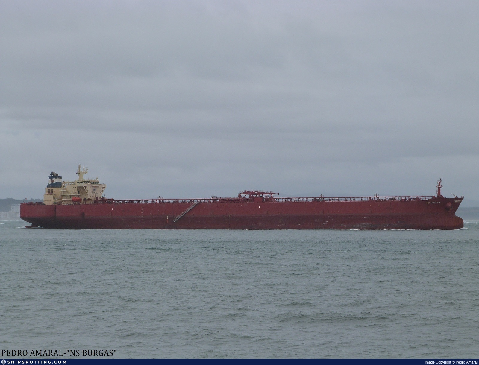
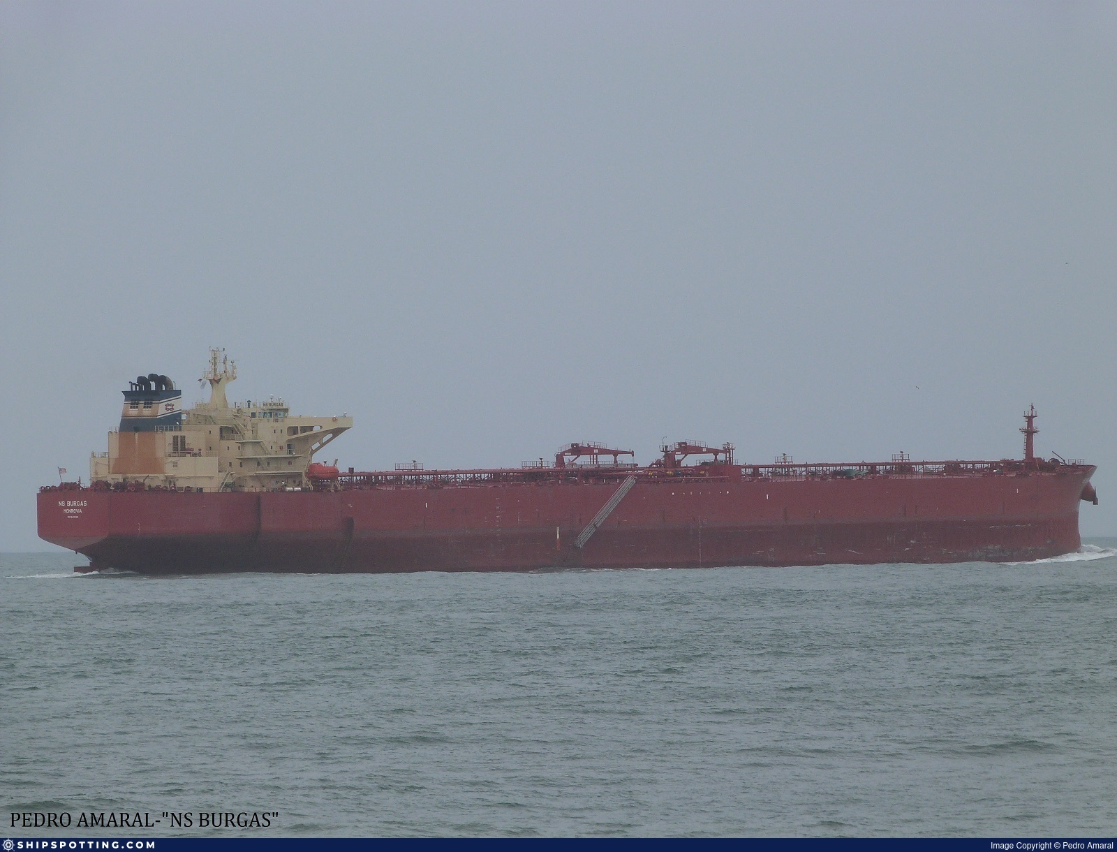
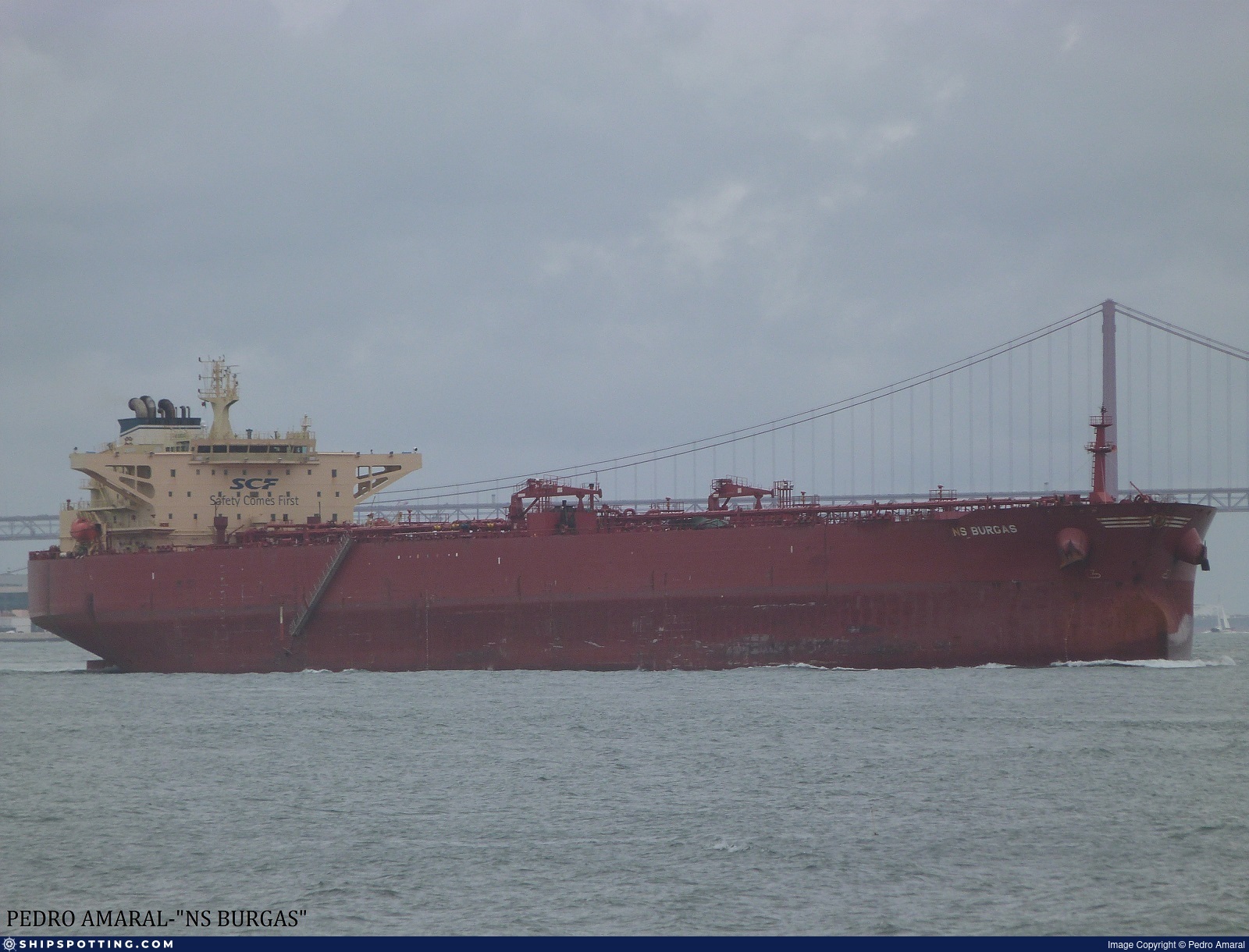
IMO 9411020
Vessel information
Sanctioned by
Company & Ownership
Management & Operations
Classification & Safety
Port State Control (PSC) Inspections
Survey Renewal & Certificates
| Code | Type | Issuer | Issued | Expires |
|---|---|---|---|---|
| 509 | Document of Compliance | Indian Register of Shipping (150) | 25/07/2022 | 28/01/2026 |
Programs & Notes
SEMA (Canada) — vessel designations | RUSSIA-EO14024 | The Russia (Sanctions) (EU Exit) Regulations 2019 | Added in EU Sanctions Package 16 | (Council Decision (CFSP) 2025/394, Annex XVI to Decision 2014/512/CFSP) | Press Release | Official Journal
DateOfListing: 2025-02-25 || Secondary sanctions risk: See Section 11 of Executive Order 14024.; Vessel Registration Identification IMO 9411020; MMSI 626378000; Linked To: JOINT STOCK COMPANY SOVCOMFLOT. || DateDesignated: 2024-11-25 | Shipping sanctions: (see “Other information”) | Shipping sanctions: a specified ship is prohibited from being provided with access to or having its master or pilot cause it to enter a port in the UK, may have its registration on the UK Ship Register terminated, and a master or pilot of a specified ship may be given a port barring direction, a detention direction, and a port entry direction or a movement direction | IMO 9411020 (“BRATSK”) is involved in activity whose object or effect is to destabilise Ukraine or undermine or threaten the territorial integrity, sovereignty or independence of Ukraine and/or to obtain a benefit from or support the Government of Russia. Namely, BRATSK is involved in carrying oil or oil products that originated in Russia from Russia to a third country.
Vessel Changes
AIS Events
50 events detected • 19 zones • Last: Jul 14, 2026
- Zone: Black Sea Sanctioned Vessel Monitoring Zone
- Duration: 1h 31m
- Data Points: 21 AIS positions
- Period: 2026-07-14T07:05:43+00:00 to 2026-07-14T08:36:44+00:00
Show Raw Evidence JSON
{
    "zone_id": "discovered_025",
    "zone_name": "Black Sea Sanctioned Vessel Monitoring Zone",
    "dwell_minutes": 91,
    "points_in_zone": 21,
    "first_point": {
        "ts": "2026-07-14T07:05:43+00:00",
        "lat": 31.14677830000000113841451820917427539825439453125,
        "lon": 32.3219466999999980316715664230287075042724609375
    },
    "last_point": {
        "ts": "2026-07-14T08:36:44+00:00",
        "lat": 30.910128300000000223235474550165235996246337890625,
        "lon": 32.3142466999999982135705067776143550872802734375
    }
}- Zone: Western Black Sea Surveillance Zone
- Duration: 1h 23m
- Data Points: 10 AIS positions
- Period: 2026-07-14T03:15:52+00:00 to 2026-07-14T04:39:24+00:00
Show Raw Evidence JSON
{
    "zone_id": "discovered_156",
    "zone_name": "Western Black Sea Surveillance Zone",
    "dwell_minutes": 83.5,
    "points_in_zone": 10,
    "first_point": {
        "ts": "2026-07-14T03:15:52+00:00",
        "lat": 31.4723417000000011967131285928189754486083984375,
        "lon": 32.28717999999999932470018393360078334808349609375
    },
    "last_point": {
        "ts": "2026-07-14T04:39:24+00:00",
        "lat": 31.436891700000000327008820022456347942352294921875,
        "lon": 32.4064266999999972540535964071750640869140625
    }
}- Zone: Black Sea Sanctioned Vessel Monitoring Zone
- Duration: 6h 9m
- Data Points: 2 AIS positions
- Period: 2026-07-13T13:25:55+00:00 to 2026-07-13T19:34:55+00:00
Show Raw Evidence JSON
{
    "zone_id": "discovered_025",
    "zone_name": "Black Sea Sanctioned Vessel Monitoring Zone",
    "dwell_minutes": 369,
    "points_in_zone": 2,
    "first_point": {
        "ts": "2026-07-13T13:25:55+00:00",
        "lat": 31.47070670000000092159098130650818347930908203125,
        "lon": 32.289531699999997726990841329097747802734375
    },
    "last_point": {
        "ts": "2026-07-13T19:34:55+00:00",
        "lat": 31.47078499999999934289007796905934810638427734375,
        "lon": 32.28955669999999855690475669689476490020751953125
    }
}- Zone: Western Black Sea Surveillance Zone
- Duration: 6h 9m
- Data Points: 2 AIS positions
- Period: 2026-07-13T13:25:55+00:00 to 2026-07-13T19:34:55+00:00
Show Raw Evidence JSON
{
    "zone_id": "discovered_156",
    "zone_name": "Western Black Sea Surveillance Zone",
    "dwell_minutes": 369,
    "points_in_zone": 2,
    "first_point": {
        "ts": "2026-07-13T13:25:55+00:00",
        "lat": 31.47070670000000092159098130650818347930908203125,
        "lon": 32.289531699999997726990841329097747802734375
    },
    "last_point": {
        "ts": "2026-07-13T19:34:55+00:00",
        "lat": 31.47078499999999934289007796905934810638427734375,
        "lon": 32.28955669999999855690475669689476490020751953125
    }
}- Zone: Western Black Sea Surveillance Zone
- Duration: 3h 23m
- Data Points: 13 AIS positions
- Period: 2026-07-13T10:02:41+00:00 to 2026-07-13T13:25:55+00:00
Show Raw Evidence JSON
{
    "zone_id": "discovered_156",
    "zone_name": "Western Black Sea Surveillance Zone",
    "dwell_minutes": 203.19999999999998863131622783839702606201171875,
    "points_in_zone": 13,
    "first_point": {
        "ts": "2026-07-13T10:02:41+00:00",
        "lat": 31.47611330000000151585481944493949413299560546875,
        "lon": 32.2746350000000035151970223523676395416259765625
    },
    "last_point": {
        "ts": "2026-07-13T13:25:55+00:00",
        "lat": 31.47070670000000092159098130650818347930908203125,
        "lon": 32.289531699999997726990841329097747802734375
    }
}- Zone: Black Sea Sanctioned Vessel Monitoring Zone
- Duration: 3h 23m
- Data Points: 13 AIS positions
- Period: 2026-07-13T10:02:41+00:00 to 2026-07-13T13:25:55+00:00
Show Raw Evidence JSON
{
    "zone_id": "discovered_025",
    "zone_name": "Black Sea Sanctioned Vessel Monitoring Zone",
    "dwell_minutes": 203.19999999999998863131622783839702606201171875,
    "points_in_zone": 13,
    "first_point": {
        "ts": "2026-07-13T10:02:41+00:00",
        "lat": 31.47611330000000151585481944493949413299560546875,
        "lon": 32.2746350000000035151970223523676395416259765625
    },
    "last_point": {
        "ts": "2026-07-13T13:25:55+00:00",
        "lat": 31.47070670000000092159098130650818347930908203125,
        "lon": 32.289531699999997726990841329097747802734375
    }
}- Zone: Western Black Sea Surveillance Zone
- Duration: 3h 30m
- Data Points: 15 AIS positions
- Period: 2026-07-13T09:55:20+00:00 to 2026-07-13T13:25:55+00:00
Show Raw Evidence JSON
{
    "zone_id": "discovered_156",
    "zone_name": "Western Black Sea Surveillance Zone",
    "dwell_minutes": 210.599999999999994315658113919198513031005859375,
    "points_in_zone": 15,
    "first_point": {
        "ts": "2026-07-13T09:55:20+00:00",
        "lat": 31.483001699999999090096025611273944377899169921875,
        "lon": 32.26989499999999821966412127949297428131103515625
    },
    "last_point": {
        "ts": "2026-07-13T13:25:55+00:00",
        "lat": 31.47070670000000092159098130650818347930908203125,
        "lon": 32.289531699999997726990841329097747802734375
    }
}- Zone: Black Sea Sanctioned Vessel Monitoring Zone
- Duration: 3h 35m
- Data Points: 17 AIS positions
- Period: 2026-07-13T09:50:03+00:00 to 2026-07-13T13:25:55+00:00
Show Raw Evidence JSON
{
    "zone_id": "discovered_025",
    "zone_name": "Black Sea Sanctioned Vessel Monitoring Zone",
    "dwell_minutes": 215.900000000000005684341886080801486968994140625,
    "points_in_zone": 17,
    "first_point": {
        "ts": "2026-07-13T09:50:03+00:00",
        "lat": 31.486598300000000705267666489817202091217041015625,
        "lon": 32.26234670000000193113010027445852756500244140625
    },
    "last_point": {
        "ts": "2026-07-13T13:25:55+00:00",
        "lat": 31.47070670000000092159098130650818347930908203125,
        "lon": 32.289531699999997726990841329097747802734375
    }
}- Gap Duration: 4h 8m
- Last Seen: 2026-07-13T05:41:41+00:00 at 32.0125, 31.6062 (Zone: Black Sea Sanctioned Vessel Monitoring Zone)
- Next Seen: 2026-07-13T09:50:03+00:00 at 31.4866, 32.2623
🛰️ Gap Corroboration
These are snapshots that may corroborate presence during the gap. They do not reconstruct a continuous route.
SAR Imagery (Sentinel-1)
Status: ✗ No SAR coverage
No Sentinel-1 scenes covering corridor and time window
VIIRS Thermal Anomaly
Status: ✗ No detections
No VIIRS thermal/light detections in corridor
Show Raw Evidence JSON
{
    "gap_minutes": 248.400000000000005684341886080801486968994140625,
    "last_seen": {
        "ts": "2026-07-13T05:41:41+00:00",
        "lat": 32.0125232999999980165739543735980987548828125,
        "lon": 31.606171700000000868158167577348649501800537109375,
        "sog": 12.0999999999999996447286321199499070644378662109375,
        "zone_id": "discovered_025"
    },
    "next_seen": {
        "ts": "2026-07-13T09:50:03+00:00",
        "lat": 31.486598300000000705267666489817202091217041015625,
        "lon": 32.26234670000000193113010027445852756500244140625,
        "zone_ids": [
            "discovered_025"
        ]
    },
    "gap_enrichment": {
        "status": "not_found",
        "corridor": {
            "start": {
                "lat": 32.0125232999999980165739543735980987548828125,
                "lon": 31.606171700000000868158167577348649501800537109375,
                "ts": "2026-07-13T05:41:41+00:00"
            },
            "end": {
                "lat": 31.486598300000000705267666489817202091217041015625,
                "lon": 32.26234670000000193113010027445852756500244140625,
                "ts": "2026-07-13T09:50:03+00:00"
            },
            "bbox": {
                "min_lat": 31.30641800000000074533090810291469097137451171875,
                "min_lon": 31.394283999999998968633008189499378204345703125,
                "max_lat": 32.19270300000000162299329531379044055938720703125,
                "max_lon": 32.47423500000000018417267710901796817779541015625
            },
            "buffer_km": 20
        },
        "sar": {
            "status": "not_found",
            "notes": "No Sentinel-1 scenes covering corridor and time window"
        },
        "viirs": {
            "status": "not_found",
            "notes": "No VIIRS thermal\/light detections in corridor"
        },
        "searched_at": "2026-07-13T10:15:02.121559+00:00"
    }
}- Zone: Black Sea Sanctioned Vessel Monitoring Zone
- Duration: 5h 42m
- Data Points: 20 AIS positions
- Period: 2026-07-13T05:03:10+00:00 to 2026-07-13T10:45:22+00:00
Show Raw Evidence JSON
{
    "zone_id": "discovered_025",
    "zone_name": "Black Sea Sanctioned Vessel Monitoring Zone",
    "dwell_minutes": 342.19999999999998863131622783839702606201171875,
    "points_in_zone": 20,
    "first_point": {
        "ts": "2026-07-13T05:03:10+00:00",
        "lat": 32.10371669999999966194081935100257396697998046875,
        "lon": 31.502321699999999538022166234441101551055908203125
    },
    "last_point": {
        "ts": "2026-07-13T10:45:22+00:00",
        "lat": 31.47023829999999833262336323969066143035888671875,
        "lon": 32.2894050000000021327650756575167179107666015625
    }
}- Zone: Black Sea Sanctioned Vessel Monitoring Zone
- Duration: 6h 33m
- Data Points: 34 AIS positions
- Period: 2026-07-13T04:11:32+00:00 to 2026-07-13T10:45:22+00:00
Show Raw Evidence JSON
{
    "zone_id": "discovered_025",
    "zone_name": "Black Sea Sanctioned Vessel Monitoring Zone",
    "dwell_minutes": 393.80000000000001136868377216160297393798828125,
    "points_in_zone": 34,
    "first_point": {
        "ts": "2026-07-13T04:11:32+00:00",
        "lat": 32.2225083000000012134478311054408550262451171875,
        "lon": 31.365946699999998514840626739896833896636962890625
    },
    "last_point": {
        "ts": "2026-07-13T10:45:22+00:00",
        "lat": 31.47023829999999833262336323969066143035888671875,
        "lon": 32.2894050000000021327650756575167179107666015625
    }
}- Zone: Black Sea Sanctioned Vessel Monitoring Zone
- Duration: 6h 37m
- Data Points: 39 AIS positions
- Period: 2026-07-13T03:50:44+00:00 to 2026-07-13T10:28:41+00:00
Show Raw Evidence JSON
{
    "zone_id": "discovered_025",
    "zone_name": "Black Sea Sanctioned Vessel Monitoring Zone",
    "dwell_minutes": 397.8999999999999772626324556767940521240234375,
    "points_in_zone": 39,
    "first_point": {
        "ts": "2026-07-13T03:50:44+00:00",
        "lat": 32.26690500000000128011379274539649486541748046875,
        "lon": 31.30933329999999870096871745772659778594970703125
    },
    "last_point": {
        "ts": "2026-07-13T10:28:41+00:00",
        "lat": 31.460653300000000598402039031498134136199951171875,
        "lon": 32.2869467000000014422766980715095996856689453125
    }
}- Zone: Black Sea Sanctioned Vessel Monitoring Zone
- Duration: 3h 33m
- Data Points: 38 AIS positions
- Period: 2026-07-13T02:08:28+00:00 to 2026-07-13T05:41:41+00:00
Show Raw Evidence JSON
{
    "zone_id": "discovered_025",
    "zone_name": "Black Sea Sanctioned Vessel Monitoring Zone",
    "dwell_minutes": 213.19999999999998863131622783839702606201171875,
    "points_in_zone": 38,
    "first_point": {
        "ts": "2026-07-13T02:08:28+00:00",
        "lat": 32.51345169999999740184648544527590274810791015625,
        "lon": 31.05902999999999991587174008600413799285888671875
    },
    "last_point": {
        "ts": "2026-07-13T05:41:41+00:00",
        "lat": 32.0125232999999980165739543735980987548828125,
        "lon": 31.606171700000000868158167577348649501800537109375
    }
}- Zone: Cape Peninsula Surveillance Zone
- Duration: 2h 47m
- Data Points: 4 AIS positions
- Period: 2026-07-13T00:16:50+00:00 to 2026-07-13T03:04:09+00:00
Show Raw Evidence JSON
{
    "zone_id": "discovered_071",
    "zone_name": "Cape Peninsula Surveillance Zone",
    "dwell_minutes": 167.30000000000001136868377216160297393798828125,
    "points_in_zone": 4,
    "first_point": {
        "ts": "2026-07-13T00:16:50+00:00",
        "lat": 32.64428500000000354930307366885244846343994140625,
        "lon": 30.665240000000000719637682777829468250274658203125
    },
    "last_point": {
        "ts": "2026-07-13T03:04:09+00:00",
        "lat": 32.382378299999999171632225625216960906982421875,
        "lon": 31.203611699999999729016053606756031513214111328125
    }
}- Zone: Southeast Aegean Monitoring Zone
- Duration: 1h 6m
- Data Points: 20 AIS positions
- Period: 2026-07-12T23:19:49+00:00 to 2026-07-13T00:26:39+00:00
Show Raw Evidence JSON
{
    "zone_id": "discovered_075",
    "zone_name": "Southeast Aegean Monitoring Zone",
    "dwell_minutes": 66.7999999999999971578290569595992565155029296875,
    "points_in_zone": 20,
    "first_point": {
        "ts": "2026-07-12T23:19:49+00:00",
        "lat": 32.6969433000000009315044735558331012725830078125,
        "lon": 30.4550066999999984318492352031171321868896484375
    },
    "last_point": {
        "ts": "2026-07-13T00:26:39+00:00",
        "lat": 32.63544499999999715100784669630229473114013671875,
        "lon": 30.70139999999999957935870043002068996429443359375
    }
}- Zone: Southeast Aegean Monitoring Zone
- Duration: 2h 15m
- Data Points: 25 AIS positions
- Period: 2026-07-12T22:11:09+00:00 to 2026-07-13T00:26:39+00:00
Show Raw Evidence JSON
{
    "zone_id": "discovered_075",
    "zone_name": "Southeast Aegean Monitoring Zone",
    "dwell_minutes": 135.5,
    "points_in_zone": 25,
    "first_point": {
        "ts": "2026-07-12T22:11:09+00:00",
        "lat": 32.75976829999999750953065813519060611724853515625,
        "lon": 30.2039366999999998597559169866144657135009765625
    },
    "last_point": {
        "ts": "2026-07-13T00:26:39+00:00",
        "lat": 32.63544499999999715100784669630229473114013671875,
        "lon": 30.70139999999999957935870043002068996429443359375
    }
}- Zone: Northern Baltic Sea Surveillance Zone
- Duration: 1h 11m
- Data Points: 12 AIS positions
- Period: 2026-07-10T05:04:39+00:00 to 2026-07-10T06:16:19+00:00
Show Raw Evidence JSON
{
    "zone_id": "discovered_039",
    "zone_name": "Northern Baltic Sea Surveillance Zone",
    "dwell_minutes": 71.7000000000000028421709430404007434844970703125,
    "points_in_zone": 12,
    "first_point": {
        "ts": "2026-07-10T05:04:39+00:00",
        "lat": 36.2824566999999973404555930756032466888427734375,
        "lon": 15.157541699999999451620169566012918949127197265625
    },
    "last_point": {
        "ts": "2026-07-10T06:16:19+00:00",
        "lat": 36.21430170000000003938112058676779270172119140625,
        "lon": 15.452916699999999394776750705204904079437255859375
    }
}- Zone: Gulf of Oman Sanctioned Vessel Monitoring Zone
- Duration: 1h 13m
- Data Points: 13 AIS positions
- Period: 2026-07-10T05:02:39+00:00 to 2026-07-10T06:16:19+00:00
Show Raw Evidence JSON
{
    "zone_id": "discovered_032",
    "zone_name": "Gulf of Oman Sanctioned Vessel Monitoring Zone",
    "dwell_minutes": 73.7000000000000028421709430404007434844970703125,
    "points_in_zone": 13,
    "first_point": {
        "ts": "2026-07-10T05:02:39+00:00",
        "lat": 36.28432500000000260342858382500708103179931640625,
        "lon": 15.14933500000000066165739553980529308319091796875
    },
    "last_point": {
        "ts": "2026-07-10T06:16:19+00:00",
        "lat": 36.21430170000000003938112058676779270172119140625,
        "lon": 15.452916699999999394776750705204904079437255859375
    }
}- Zone: Gulf of Oman Sanctioned Vessel Monitoring Zone
- Duration: 1h 42m
- Data Points: 22 AIS positions
- Period: 2026-07-10T04:33:59+00:00 to 2026-07-10T06:16:19+00:00
Show Raw Evidence JSON
{
    "zone_id": "discovered_032",
    "zone_name": "Gulf of Oman Sanctioned Vessel Monitoring Zone",
    "dwell_minutes": 102.2999999999999971578290569595992565155029296875,
    "points_in_zone": 22,
    "first_point": {
        "ts": "2026-07-10T04:33:59+00:00",
        "lat": 36.3112883000000010724761523306369781494140625,
        "lon": 15.03296830000000028348949854262173175811767578125
    },
    "last_point": {
        "ts": "2026-07-10T06:16:19+00:00",
        "lat": 36.21430170000000003938112058676779270172119140625,
        "lon": 15.452916699999999394776750705204904079437255859375
    }
}- Zone: Central Mediterranean Sanctions Monitoring Zone
- Duration: 3h 21m
- Data Points: 8 AIS positions
- Period: 2026-07-09T12:00:40+00:00 to 2026-07-09T15:22:29+00:00
Show Raw Evidence JSON
{
    "zone_id": "discovered_016",
    "zone_name": "Central Mediterranean Sanctions Monitoring Zone",
    "dwell_minutes": 201.80000000000001136868377216160297393798828125,
    "points_in_zone": 8,
    "first_point": {
        "ts": "2026-07-09T12:00:40+00:00",
        "lat": 37.39514669999999796345946379005908966064453125,
        "lon": 11.02726499999999987267074175179004669189453125
    },
    "last_point": {
        "ts": "2026-07-09T15:22:29+00:00",
        "lat": 37.1621616999999986319380695931613445281982421875,
        "lon": 11.8072032999999994018480720114894211292266845703125
    }
}- Zone: Alboran Sea Surveillance Zone
- Duration: 1h 17m
- Data Points: 34 AIS positions
- Period: 2026-07-09T01:00:11+00:00 to 2026-07-09T02:17:31+00:00
Show Raw Evidence JSON
{
    "zone_id": "discovered_103",
    "zone_name": "Alboran Sea Surveillance Zone",
    "dwell_minutes": 77.2999999999999971578290569595992565155029296875,
    "points_in_zone": 34,
    "first_point": {
        "ts": "2026-07-09T01:00:11+00:00",
        "lat": 37.6968566999999978861524141393601894378662109375,
        "lon": 8.21841500000000024783730623312294483184814453125
    },
    "last_point": {
        "ts": "2026-07-09T02:17:31+00:00",
        "lat": 37.72343169999999901165210758335888385772705078125,
        "lon": 8.5433383000000002738261173362843692302703857421875
    }
}- Zone: Alboran Sea Surveillance Zone
- Duration: 2h 15m
- Data Points: 50 AIS positions
- Period: 2026-07-09T00:01:40+00:00 to 2026-07-09T02:17:31+00:00
Show Raw Evidence JSON
{
    "zone_id": "discovered_103",
    "zone_name": "Alboran Sea Surveillance Zone",
    "dwell_minutes": 135.80000000000001136868377216160297393798828125,
    "points_in_zone": 50,
    "first_point": {
        "ts": "2026-07-09T00:01:40+00:00",
        "lat": 37.68569500000000260797605733387172222137451171875,
        "lon": 7.98173170000000009594032235327176749706268310546875
    },
    "last_point": {
        "ts": "2026-07-09T02:17:31+00:00",
        "lat": 37.72343169999999901165210758335888385772705078125,
        "lon": 8.5433383000000002738261173362843692302703857421875
    }
}- Zone: Central Iberian Sea Monitoring Zone
- Duration: 1h 51m
- Data Points: 15 AIS positions
- Period: 2026-07-08T11:11:59+00:00 to 2026-07-08T13:02:59+00:00
Show Raw Evidence JSON
{
    "zone_id": "discovered_204",
    "zone_name": "Central Iberian Sea Monitoring Zone",
    "dwell_minutes": 111,
    "points_in_zone": 15,
    "first_point": {
        "ts": "2026-07-08T11:11:59+00:00",
        "lat": 37.40987830000000258223735727369785308837890625,
        "lon": 4.84739170000000019200570022803731262683868408203125
    },
    "last_point": {
        "ts": "2026-07-08T13:02:59+00:00",
        "lat": 37.44789670000000114669091999530792236328125,
        "lon": 5.27950669999999977477500578970648348331451416015625
    }
}- Zone: English Channel Surveillance Zone
- Duration: 2h 24m
- Data Points: 7 AIS positions
- Period: 2026-07-08T09:03:59+00:00 to 2026-07-08T11:28:20+00:00
Show Raw Evidence JSON
{
    "zone_id": "discovered_077",
    "zone_name": "English Channel Surveillance Zone",
    "dwell_minutes": 144.30000000000001136868377216160297393798828125,
    "points_in_zone": 7,
    "first_point": {
        "ts": "2026-07-08T09:03:59+00:00",
        "lat": 37.3650166999999981953806127421557903289794921875,
        "lon": 4.3234750000000001790567694115452468395233154296875
    },
    "last_point": {
        "ts": "2026-07-08T11:28:20+00:00",
        "lat": 37.4167417000000028792783268727362155914306640625,
        "lon": 4.91080830000000023716211217106319963932037353515625
    }
}- Zone: English Channel Surveillance Zone
- Duration: 2h 36m
- Data Points: 10 AIS positions
- Period: 2026-07-08T08:52:19+00:00 to 2026-07-08T11:28:20+00:00
Show Raw Evidence JSON
{
    "zone_id": "discovered_077",
    "zone_name": "English Channel Surveillance Zone",
    "dwell_minutes": 156,
    "points_in_zone": 10,
    "first_point": {
        "ts": "2026-07-08T08:52:19+00:00",
        "lat": 37.361238299999996570477378554642200469970703125,
        "lon": 4.27470329999999965053802952752448618412017822265625
    },
    "last_point": {
        "ts": "2026-07-08T11:28:20+00:00",
        "lat": 37.4167417000000028792783268727362155914306640625,
        "lon": 4.91080830000000023716211217106319963932037353515625
    }
}- Zone: Alboran Sea Monitoring Zone
- Duration: 2h 12m
- Data Points: 12 AIS positions
- Period: 2026-07-08T07:02:51+00:00 to 2026-07-08T09:15:03+00:00
Show Raw Evidence JSON
{
    "zone_id": "discovered_135",
    "zone_name": "Alboran Sea Monitoring Zone",
    "dwell_minutes": 132.19999999999998863131622783839702606201171875,
    "points_in_zone": 12,
    "first_point": {
        "ts": "2026-07-08T07:02:51+00:00",
        "lat": 37.32008170000000291111064143478870391845703125,
        "lon": 3.8208617000000000274440026259981095790863037109375
    },
    "last_point": {
        "ts": "2026-07-08T09:15:03+00:00",
        "lat": 37.36857169999999683795977034606039524078369140625,
        "lon": 4.3695933000000000134832589537836611270904541015625
    }
}- Zone: Eastern Mediterranean Monitoring Zone
- Duration: 1h 54m
- Data Points: 3 AIS positions
- Period: 2026-07-08T03:10:20+00:00 to 2026-07-08T05:04:50+00:00
Show Raw Evidence JSON
{
    "zone_id": "discovered_154",
    "zone_name": "Eastern Mediterranean Monitoring Zone",
    "dwell_minutes": 114.5,
    "points_in_zone": 3,
    "first_point": {
        "ts": "2026-07-08T03:10:20+00:00",
        "lat": 37.20568329999999690471668145619332790374755859375,
        "lon": 2.854911700000000163157665156177245080471038818359375
    },
    "last_point": {
        "ts": "2026-07-08T05:04:50+00:00",
        "lat": 37.26681669999999968467818689532577991485595703125,
        "lon": 3.328668299999999913296733211609534919261932373046875
    }
}- Zone: Black Sea Sanctioned Vessel Monitoring Zone
- Duration: 1h 39m
- Data Points: 4 AIS positions
- Period: 2026-07-08T01:56:19+00:00 to 2026-07-08T03:35:41+00:00
Show Raw Evidence JSON
{
    "zone_id": "discovered_033",
    "zone_name": "Black Sea Sanctioned Vessel Monitoring Zone",
    "dwell_minutes": 99.400000000000005684341886080801486968994140625,
    "points_in_zone": 4,
    "first_point": {
        "ts": "2026-07-08T01:56:19+00:00",
        "lat": 37.11911669999999929814293864183127880096435546875,
        "lon": 2.561321700000000145536205309326760470867156982421875
    },
    "last_point": {
        "ts": "2026-07-08T03:35:41+00:00",
        "lat": 37.23512329999999792562448419630527496337890625,
        "lon": 2.95554670000000019314256860525347292423248291015625
    }
}- Zone: Black Sea Sanctioned Vessel Monitoring Zone
- Duration: 3h 20m
- Data Points: 8 AIS positions
- Period: 2026-07-08T00:14:59+00:00 to 2026-07-08T03:35:41+00:00
Show Raw Evidence JSON
{
    "zone_id": "discovered_033",
    "zone_name": "Black Sea Sanctioned Vessel Monitoring Zone",
    "dwell_minutes": 200.69999999999998863131622783839702606201171875,
    "points_in_zone": 8,
    "first_point": {
        "ts": "2026-07-08T00:14:59+00:00",
        "lat": 37.02624829999999889196260483004152774810791015625,
        "lon": 2.145799999999999929656269159750081598758697509765625
    },
    "last_point": {
        "ts": "2026-07-08T03:35:41+00:00",
        "lat": 37.23512329999999792562448419630527496337890625,
        "lon": 2.95554670000000019314256860525347292423248291015625
    }
}- Zone: Black Sea Sanctioned Vessel Monitoring Zone
- Duration: 4h 34m
- Data Points: 14 AIS positions
- Period: 2026-07-07T23:01:41+00:00 to 2026-07-08T03:35:41+00:00
Show Raw Evidence JSON
{
    "zone_id": "discovered_033",
    "zone_name": "Black Sea Sanctioned Vessel Monitoring Zone",
    "dwell_minutes": 274,
    "points_in_zone": 14,
    "first_point": {
        "ts": "2026-07-07T23:01:41+00:00",
        "lat": 36.98340499999999764213498565368354320526123046875,
        "lon": 1.8395582999999999795903704580268822610378265380859375
    },
    "last_point": {
        "ts": "2026-07-08T03:35:41+00:00",
        "lat": 37.23512329999999792562448419630527496337890625,
        "lon": 2.95554670000000019314256860525347292423248291015625
    }
}- Zone: Black Sea Sanctioned Vessel Monitoring Zone
- Duration: 5h 6m
- Data Points: 22 AIS positions
- Period: 2026-07-07T22:29:40+00:00 to 2026-07-08T03:35:41+00:00
Show Raw Evidence JSON
{
    "zone_id": "discovered_033",
    "zone_name": "Black Sea Sanctioned Vessel Monitoring Zone",
    "dwell_minutes": 306,
    "points_in_zone": 22,
    "first_point": {
        "ts": "2026-07-07T22:29:40+00:00",
        "lat": 36.9537066999999979088897816836833953857421875,
        "lon": 1.7082317000000000195569782590609975159168243408203125
    },
    "last_point": {
        "ts": "2026-07-08T03:35:41+00:00",
        "lat": 37.23512329999999792562448419630527496337890625,
        "lon": 2.95554670000000019314256860525347292423248291015625
    }
}- Zone: Western Approaches Monitoring Zone
- Duration: 1h 26m
- Data Points: 20 AIS positions
- Period: 2026-07-07T22:16:30+00:00 to 2026-07-07T23:42:59+00:00
Show Raw Evidence JSON
{
    "zone_id": "discovered_080",
    "zone_name": "Western Approaches Monitoring Zone",
    "dwell_minutes": 86.5,
    "points_in_zone": 20,
    "first_point": {
        "ts": "2026-07-07T22:16:30+00:00",
        "lat": 36.942436700000001792432158254086971282958984375,
        "lon": 1.6545167000000000623316509518190287053585052490234375
    },
    "last_point": {
        "ts": "2026-07-07T23:42:59+00:00",
        "lat": 37.010508299999997916529537178575992584228515625,
        "lon": 2.013084999999999791242544233682565391063690185546875
    }
}- Zone: Western Approaches Monitoring Zone
- Duration: 2h 50m
- Data Points: 21 AIS positions
- Period: 2026-07-07T20:52:10+00:00 to 2026-07-07T23:42:59+00:00
Show Raw Evidence JSON
{
    "zone_id": "discovered_080",
    "zone_name": "Western Approaches Monitoring Zone",
    "dwell_minutes": 170.80000000000001136868377216160297393798828125,
    "points_in_zone": 21,
    "first_point": {
        "ts": "2026-07-07T20:52:10+00:00",
        "lat": 36.8930517000000008920324034988880157470703125,
        "lon": 1.314516699999999982395593178807757794857025146484375
    },
    "last_point": {
        "ts": "2026-07-07T23:42:59+00:00",
        "lat": 37.010508299999997916529537178575992584228515625,
        "lon": 2.013084999999999791242544233682565391063690185546875
    }
}- Zone: Southern Öresund Surveillance Zone
- Duration: 1h 9m
- Data Points: 20 AIS positions
- Period: 2026-07-07T01:00:10+00:00 to 2026-07-07T02:09:30+00:00
Show Raw Evidence JSON
{
    "zone_id": "discovered_003",
    "zone_name": "Southern \u00d6resund Surveillance Zone",
    "dwell_minutes": 69.2999999999999971578290569595992565155029296875,
    "points_in_zone": 20,
    "first_point": {
        "ts": "2026-07-07T01:00:10+00:00",
        "lat": 36.19134999999999990905052982270717620849609375,
        "lon": -3.492403299999999877201162234996445477008819580078125
    },
    "last_point": {
        "ts": "2026-07-07T02:09:30+00:00",
        "lat": 36.23687499999999772626324556767940521240234375,
        "lon": -3.19969169999999980547045197454281151294708251953125
    }
}- Zone: Southern Öresund Surveillance Zone
- Duration: 2h 7m
- Data Points: 40 AIS positions
- Period: 2026-07-07T00:02:30+00:00 to 2026-07-07T02:09:30+00:00
Show Raw Evidence JSON
{
    "zone_id": "discovered_003",
    "zone_name": "Southern \u00d6resund Surveillance Zone",
    "dwell_minutes": 127,
    "points_in_zone": 40,
    "first_point": {
        "ts": "2026-07-07T00:02:30+00:00",
        "lat": 36.1634949999999975034370436333119869232177734375,
        "lon": -3.73879830000000001888338374556042253971099853515625
    },
    "last_point": {
        "ts": "2026-07-07T02:09:30+00:00",
        "lat": 36.23687499999999772626324556767940521240234375,
        "lon": -3.19969169999999980547045197454281151294708251953125
    }
}- Zone: Southern Öresund Surveillance Zone
- Duration: 3h 9m
- Data Points: 59 AIS positions
- Period: 2026-07-06T23:00:19+00:00 to 2026-07-07T02:09:30+00:00
Show Raw Evidence JSON
{
    "zone_id": "discovered_003",
    "zone_name": "Southern \u00d6resund Surveillance Zone",
    "dwell_minutes": 189.19999999999998863131622783839702606201171875,
    "points_in_zone": 59,
    "first_point": {
        "ts": "2026-07-06T23:00:19+00:00",
        "lat": 36.13236669999999861602191231213510036468505859375,
        "lon": -4.00864330000000013143335308996029198169708251953125
    },
    "last_point": {
        "ts": "2026-07-07T02:09:30+00:00",
        "lat": 36.23687499999999772626324556767940521240234375,
        "lon": -3.19969169999999980547045197454281151294708251953125
    }
}- Zone: Southern Öresund Surveillance Zone
- Duration: 4h 6m
- Data Points: 75 AIS positions
- Period: 2026-07-06T22:02:49+00:00 to 2026-07-07T02:09:30+00:00
Show Raw Evidence JSON
{
    "zone_id": "discovered_003",
    "zone_name": "Southern \u00d6resund Surveillance Zone",
    "dwell_minutes": 246.69999999999998863131622783839702606201171875,
    "points_in_zone": 75,
    "first_point": {
        "ts": "2026-07-06T22:02:49+00:00",
        "lat": 36.107388299999996661426848731935024261474609375,
        "lon": -4.275529999999999830606611794792115688323974609375
    },
    "last_point": {
        "ts": "2026-07-07T02:09:30+00:00",
        "lat": 36.23687499999999772626324556767940521240234375,
        "lon": -3.19969169999999980547045197454281151294708251953125
    }
}- Zone: Southern Öresund Surveillance Zone
- Duration: 5h 6m
- Data Points: 97 AIS positions
- Period: 2026-07-06T21:03:30+00:00 to 2026-07-07T02:09:30+00:00
Show Raw Evidence JSON
{
    "zone_id": "discovered_003",
    "zone_name": "Southern \u00d6resund Surveillance Zone",
    "dwell_minutes": 306,
    "points_in_zone": 97,
    "first_point": {
        "ts": "2026-07-06T21:03:30+00:00",
        "lat": 36.08896829999999766869223094545304775238037109375,
        "lon": -4.55656000000000016569856597925536334514617919921875
    },
    "last_point": {
        "ts": "2026-07-07T02:09:30+00:00",
        "lat": 36.23687499999999772626324556767940521240234375,
        "lon": -3.19969169999999980547045197454281151294708251953125
    }
}- Zone: Southern Öresund Surveillance Zone
- Duration: 6h 8m
- Data Points: 121 AIS positions
- Period: 2026-07-06T20:01:20+00:00 to 2026-07-07T02:09:30+00:00
Show Raw Evidence JSON
{
    "zone_id": "discovered_003",
    "zone_name": "Southern \u00d6resund Surveillance Zone",
    "dwell_minutes": 368.19999999999998863131622783839702606201171875,
    "points_in_zone": 121,
    "first_point": {
        "ts": "2026-07-06T20:01:20+00:00",
        "lat": 36.05644499999999652573023922741413116455078125,
        "lon": -4.83926829999999963405343805789016187191009521484375
    },
    "last_point": {
        "ts": "2026-07-07T02:09:30+00:00",
        "lat": 36.23687499999999772626324556767940521240234375,
        "lon": -3.19969169999999980547045197454281151294708251953125
    }
}- Zone: Southern Öresund Surveillance Zone
- Duration: 6h 37m
- Data Points: 134 AIS positions
- Period: 2026-07-06T19:32:20+00:00 to 2026-07-07T02:09:30+00:00
Show Raw Evidence JSON
{
    "zone_id": "discovered_003",
    "zone_name": "Southern \u00d6resund Surveillance Zone",
    "dwell_minutes": 397.19999999999998863131622783839702606201171875,
    "points_in_zone": 134,
    "first_point": {
        "ts": "2026-07-06T19:32:20+00:00",
        "lat": 36.0399383000000028687281883321702480316162109375,
        "lon": -4.97234670000000011924612408620305359363555908203125
    },
    "last_point": {
        "ts": "2026-07-07T02:09:30+00:00",
        "lat": 36.23687499999999772626324556767940521240234375,
        "lon": -3.19969169999999980547045197454281151294708251953125
    }
}- Zone: Southern Öresund Surveillance Zone
- Duration: 6h 29m
- Data Points: 139 AIS positions
- Period: 2026-07-06T18:57:10+00:00 to 2026-07-07T01:26:49+00:00
Show Raw Evidence JSON
{
    "zone_id": "discovered_003",
    "zone_name": "Southern \u00d6resund Surveillance Zone",
    "dwell_minutes": 389.6000000000000227373675443232059478759765625,
    "points_in_zone": 139,
    "first_point": {
        "ts": "2026-07-06T18:57:10+00:00",
        "lat": 36.020953300000002172964741475880146026611328125,
        "lon": -5.13246830000000020532979760901071131229400634765625
    },
    "last_point": {
        "ts": "2026-07-07T01:26:49+00:00",
        "lat": 36.21226169999999910942278802394866943359375,
        "lon": -3.38022329999999993077608451130799949169158935546875
    }
}- Zone: Ceuta/Gibraltar STS Zone
- Duration: 1h 38m
- Data Points: 37 AIS positions
- Period: 2026-07-06T17:00:19+00:00 to 2026-07-06T18:38:49+00:00
Show Raw Evidence JSON
{
    "zone_id": "osint_ceuta",
    "zone_name": "Ceuta\/Gibraltar STS Zone",
    "dwell_minutes": 98.5,
    "points_in_zone": 37,
    "first_point": {
        "ts": "2026-07-06T17:00:19+00:00",
        "lat": 35.92619169999999684250724385492503643035888671875,
        "lon": -5.61020669999999999077999746077693998813629150390625
    },
    "last_point": {
        "ts": "2026-07-06T18:38:49+00:00",
        "lat": 36.005144999999998844941728748381137847900390625,
        "lon": -5.2101883000000004386720320326276123523712158203125
    }
}- Zone: Ceuta/Gibraltar STS Zone
- Duration: 1h 57m
- Data Points: 44 AIS positions
- Period: 2026-07-06T16:41:29+00:00 to 2026-07-06T18:38:49+00:00
Show Raw Evidence JSON
{
    "zone_id": "osint_ceuta",
    "zone_name": "Ceuta\/Gibraltar STS Zone",
    "dwell_minutes": 117.2999999999999971578290569595992565155029296875,
    "points_in_zone": 44,
    "first_point": {
        "ts": "2026-07-06T16:41:29+00:00",
        "lat": 35.9176082999999977118932292796671390533447265625,
        "lon": -5.67882330000000035141738408128730952739715576171875
    },
    "last_point": {
        "ts": "2026-07-06T18:38:49+00:00",
        "lat": 36.005144999999998844941728748381137847900390625,
        "lon": -5.2101883000000004386720320326276123523712158203125
    }
}- Zone: Western Mediterranean Surveillance Zone
- Duration: 1h 32m
- Data Points: 5 AIS positions
- Period: 2026-07-06T02:01:39+00:00 to 2026-07-06T03:34:00+00:00
Show Raw Evidence JSON
{
    "zone_id": "discovered_013",
    "zone_name": "Western Mediterranean Surveillance Zone",
    "dwell_minutes": 92.2999999999999971578290569595992565155029296875,
    "points_in_zone": 5,
    "first_point": {
        "ts": "2026-07-06T02:01:39+00:00",
        "lat": 36.3685483000000004949470167048275470733642578125,
        "lon": -8.7465150000000004837374945054762065410614013671875
    },
    "last_point": {
        "ts": "2026-07-06T03:34:00+00:00",
        "lat": 36.298783299999996643236954696476459503173828125,
        "lon": -8.382793299999999447891241288743913173675537109375
    }
}- Zone: Western Mediterranean Surveillance Zone
- Duration: 1h 43m
- Data Points: 8 AIS positions
- Period: 2026-07-06T01:50:40+00:00 to 2026-07-06T03:34:00+00:00
Show Raw Evidence JSON
{
    "zone_id": "discovered_013",
    "zone_name": "Western Mediterranean Surveillance Zone",
    "dwell_minutes": 103.2999999999999971578290569595992565155029296875,
    "points_in_zone": 8,
    "first_point": {
        "ts": "2026-07-06T01:50:40+00:00",
        "lat": 36.37647170000000329537215293385088443756103515625,
        "lon": -8.7894532999999999134388417587615549564361572265625
    },
    "last_point": {
        "ts": "2026-07-06T03:34:00+00:00",
        "lat": 36.298783299999996643236954696476459503173828125,
        "lon": -8.382793299999999447891241288743913173675537109375
    }
}- Zone: Western Mediterranean Surveillance Zone
- Duration: 4h 32m
- Data Points: 9 AIS positions
- Period: 2026-07-05T23:01:20+00:00 to 2026-07-06T03:34:00+00:00
Show Raw Evidence JSON
{
    "zone_id": "discovered_013",
    "zone_name": "Western Mediterranean Surveillance Zone",
    "dwell_minutes": 272.69999999999998863131622783839702606201171875,
    "points_in_zone": 9,
    "first_point": {
        "ts": "2026-07-05T23:01:20+00:00",
        "lat": 36.56467669999999969832060742191970348358154296875,
        "lon": -9.41683330000000040627128328196704387664794921875
    },
    "last_point": {
        "ts": "2026-07-06T03:34:00+00:00",
        "lat": 36.298783299999996643236954696476459503173828125,
        "lon": -8.382793299999999447891241288743913173675537109375
    }
}- Zone: Western Mediterranean Surveillance Zone
- Duration: 4h 50m
- Data Points: 10 AIS positions
- Period: 2026-07-05T22:43:19+00:00 to 2026-07-06T03:34:00+00:00
Show Raw Evidence JSON
{
    "zone_id": "discovered_013",
    "zone_name": "Western Mediterranean Surveillance Zone",
    "dwell_minutes": 290.69999999999998863131622783839702606201171875,
    "points_in_zone": 10,
    "first_point": {
        "ts": "2026-07-05T22:43:19+00:00",
        "lat": 36.61046830000000085192368715070188045501708984375,
        "lon": -9.4669016999999993089431882253848016262054443359375
    },
    "last_point": {
        "ts": "2026-07-06T03:34:00+00:00",
        "lat": 36.298783299999996643236954696476459503173828125,
        "lon": -8.382793299999999447891241288743913173675537109375
    }
}- Zone: Strait of Gibraltar Surveillance Zone
- Duration: 2 hours
- Data Points: 19 AIS positions
- Period: 2026-07-05T21:01:19+00:00 to 2026-07-05T23:01:20+00:00
Show Raw Evidence JSON
{
    "zone_id": "discovered_118",
    "zone_name": "Strait of Gibraltar Surveillance Zone",
    "dwell_minutes": 120,
    "points_in_zone": 19,
    "first_point": {
        "ts": "2026-07-05T21:01:19+00:00",
        "lat": 36.89597830000000300287865684367716312408447265625,
        "lon": -9.6737850000000005223910193308256566524505615234375
    },
    "last_point": {
        "ts": "2026-07-05T23:01:20+00:00",
        "lat": 36.56467669999999969832060742191970348358154296875,
        "lon": -9.41683330000000040627128328196704387664794921875
    }
}- Zone: Strait of Gibraltar Surveillance Zone
- Duration: 2h 19m
- Data Points: 23 AIS positions
- Period: 2026-07-05T20:41:50+00:00 to 2026-07-05T23:01:20+00:00
Show Raw Evidence JSON
{
    "zone_id": "discovered_118",
    "zone_name": "Strait of Gibraltar Surveillance Zone",
    "dwell_minutes": 139.5,
    "points_in_zone": 23,
    "first_point": {
        "ts": "2026-07-05T20:41:50+00:00",
        "lat": 36.96161330000000333484422299079596996307373046875,
        "lon": -9.692434999999999689634933019988238811492919921875
    },
    "last_point": {
        "ts": "2026-07-05T23:01:20+00:00",
        "lat": 36.56467669999999969832060742191970348358154296875,
        "lon": -9.41683330000000040627128328196704387664794921875
    }
}- Zone: Brittany Channel Monitoring Zone
- Duration: 1h 32m
- Data Points: 20 AIS positions
- Period: 2026-07-05T20:23:59+00:00 to 2026-07-05T21:55:59+00:00
Show Raw Evidence JSON
{
    "zone_id": "discovered_081",
    "zone_name": "Brittany Channel Monitoring Zone",
    "dwell_minutes": 92,
    "points_in_zone": 20,
    "first_point": {
        "ts": "2026-07-05T20:23:59+00:00",
        "lat": 37.021171699999996462793205864727497100830078125,
        "lon": -9.70924169999999975289028952829539775848388671875
    },
    "last_point": {
        "ts": "2026-07-05T21:55:59+00:00",
        "lat": 36.7270783000000022866515791974961757659912109375,
        "lon": -9.596618299999999379679138655774295330047607421875
    }
}Source snapshot
| Sanctioner | As of | Entity ID |
|---|---|---|
| 🇬🇧 UK | 2025-09-29 | 9411020 |
| 🇺🇸 US | 2025-09-29 | 9411020 |
We mirror official lists; always verify at the source.
Sanctioned on the same day
- AKADEMIK ALEKSANDR KARPINSKIY · IMO 8227238 🇺🇸 US
- AKADEMIK LAZAREV · IMO 8408985 🇺🇸 US
- AKADEMIK PRIMAKOV · IMO 9187514 🇺🇸 US
- ALEKSANDR SOKOLOV · IMO 9889198 🇺🇸 US
- Alireza 1 · IMO 6703769 🇨🇦 CA🇺🇸 US
- Anatoly Kolodkin · IMO 9610808 🇨🇦 CA🇪🇺 EU🇬🇧 UK🇺🇸 US
- Antarktika · IMO 9413559 🇨🇦 CA🇪🇺 EU🇳🇿 NZ🇬🇧 UK🇺🇸 US
- BALTIYSKIY-111 · IMO 7612448 🇨🇦 CA🇬🇧 UK🇺🇸 US