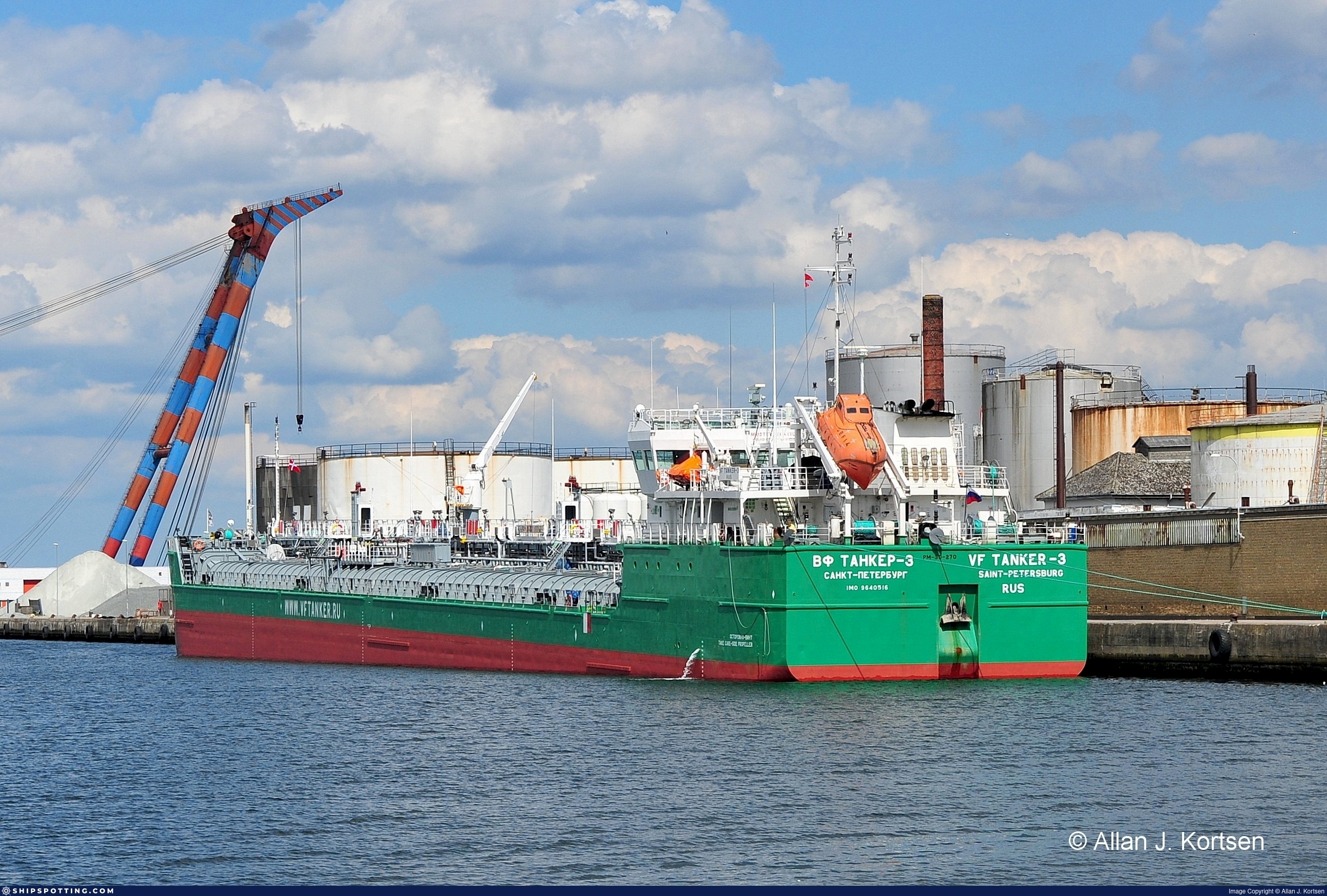
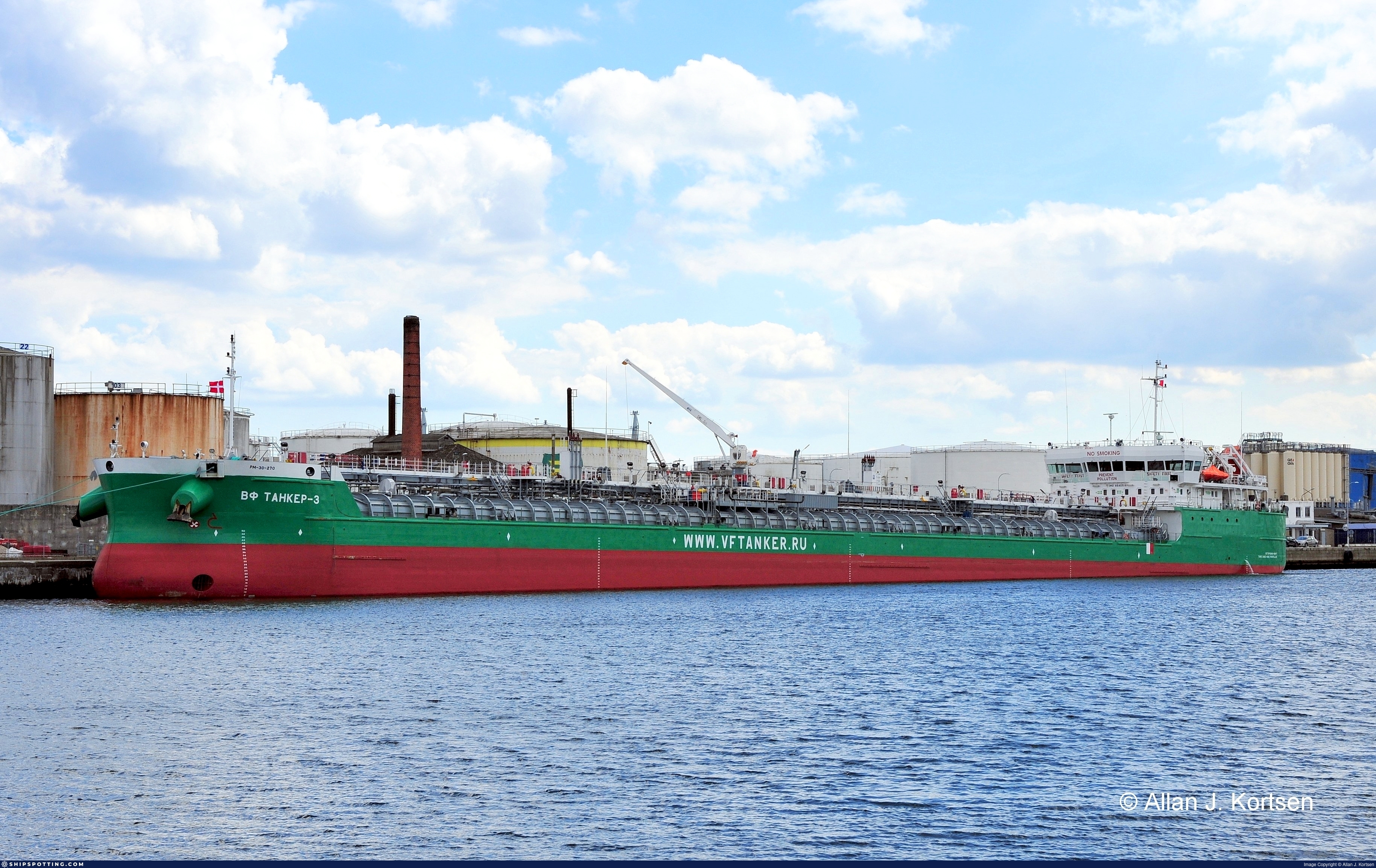
IMO 9640516
Vessel information
Sanctioned by
Company & Ownership
Management & Operations
Classification & Safety
Port State Control (PSC) Inspections
Programs & Notes
EU Russia Sanctions – Shadow Fleet | SEMA (Canada) — vessel designations | The Russia (Sanctions) (EU Exit) Regulations 2019
DateOfListing: 2025-05-21 || DateDesignated: 2025-07-21 | Shipping sanctions: (see “Other information”) | Shipping sanctions: a specified ship is prohibited from being provided with access to or having its master or pilot cause it to enter a port in the UK, may have its registration on the UK Ship Register terminated, and a master or pilot of a specified ship may be given a port barring direction, a detention direction, and a port entry direction or a movement direction. | IMO 9640516 (“Vf Tanker-3”) is, has been or is likely to be involved in activity whose object or effect is to destabilise Ukraine or undermine or threaten the territorial integrity, sovereignty or independence of Ukraine or to obtain a benefit from or support the Government of Russia. Namely, 9640516 is involved in carrying oil or oil products that originated in Russia from Russia to a third country.
Vessel Changes
 🔄 Owner
 🔄 Owner
AIS Events
50 events detected • 1 zone • Last: Jul 8, 2026
- Zone: Bosphorus/Dardanelles Approach
- Duration: 1h 33m
- Data Points: 6 AIS positions
- Period: 2026-07-08T19:19:14+00:00 to 2026-07-08T20:52:32+00:00
Show Raw Evidence JSON
{
    "zone_id": "osint_bosphorus",
    "zone_name": "Bosphorus\/Dardanelles Approach",
    "dwell_minutes": 93.2999999999999971578290569595992565155029296875,
    "points_in_zone": 6,
    "first_point": {
        "ts": "2026-07-08T19:19:14+00:00",
        "lat": 40.9656183000000027050191420130431652069091796875,
        "lon": 28.745323299999999022702468209899961948394775390625
    },
    "last_point": {
        "ts": "2026-07-08T20:52:32+00:00",
        "lat": 40.96030499999999818783180671744048595428466796875,
        "lon": 28.750240000000001572288965689949691295623779296875
    }
}- Duration: 2h 51m
- Radius: 691 meters
- Data Points: 10 AIS positions
- Centroid: 40.9658, 28.7465
- Zone: Bosphorus/Dardanelles Approach
Show Raw Evidence JSON
{
    "radius_m": 691.1000000000000227373675443232059478759765625,
    "duration_minutes": 171.19999999999998863131622783839702606201171875,
    "points": 10,
    "centroid": {
        "lat": 40.9658289999999993824530974961817264556884765625,
        "lon": 28.74646048000000320143954013474285602569580078125
    },
    "bbox": {
        "min_lat": 40.96030499999999818783180671744048595428466796875,
        "min_lon": 28.744403299999998324665284599177539348602294921875,
        "max_lat": 40.9670483000000018591890693642199039459228515625,
        "max_lon": 28.750240000000001572288965689949691295623779296875
    },
    "zone_id": "osint_bosphorus"
}- Zone: Bosphorus/Dardanelles Approach
- Duration: 2h 51m
- Data Points: 10 AIS positions
- Period: 2026-07-08T18:01:18+00:00 to 2026-07-08T20:52:32+00:00
Show Raw Evidence JSON
{
    "zone_id": "osint_bosphorus",
    "zone_name": "Bosphorus\/Dardanelles Approach",
    "dwell_minutes": 171.19999999999998863131622783839702606201171875,
    "points_in_zone": 10,
    "first_point": {
        "ts": "2026-07-08T18:01:18+00:00",
        "lat": 40.9670483000000018591890693642199039459228515625,
        "lon": 28.7473083000000002584783942438662052154541015625
    },
    "last_point": {
        "ts": "2026-07-08T20:52:32+00:00",
        "lat": 40.96030499999999818783180671744048595428466796875,
        "lon": 28.750240000000001572288965689949691295623779296875
    }
}- Duration: 3h 46m
- Radius: 719 meters
- Data Points: 15 AIS positions
- Centroid: 40.9662, 28.7468
- Zone: Bosphorus/Dardanelles Approach
Show Raw Evidence JSON
{
    "radius_m": 719,
    "duration_minutes": 226.19999999999998863131622783839702606201171875,
    "points": 15,
    "centroid": {
        "lat": 40.966215666666670358608826063573360443115234375,
        "lon": 28.746755213333326395286348997615277767181396484375
    },
    "bbox": {
        "min_lat": 40.96030499999999818783180671744048595428466796875,
        "min_lon": 28.744403299999998324665284599177539348602294921875,
        "max_lat": 40.9670483000000018591890693642199039459228515625,
        "max_lon": 28.750240000000001572288965689949691295623779296875
    },
    "zone_id": "osint_bosphorus"
}- Zone: Bosphorus/Dardanelles Approach
- Duration: 3h 46m
- Data Points: 15 AIS positions
- Period: 2026-07-08T17:06:17+00:00 to 2026-07-08T20:52:32+00:00
Show Raw Evidence JSON
{
    "zone_id": "osint_bosphorus",
    "zone_name": "Bosphorus\/Dardanelles Approach",
    "dwell_minutes": 226.19999999999998863131622783839702606201171875,
    "points_in_zone": 15,
    "first_point": {
        "ts": "2026-07-08T17:06:17+00:00",
        "lat": 40.9670066999999988865965860895812511444091796875,
        "lon": 28.747396699999999469810063601471483707427978515625
    },
    "last_point": {
        "ts": "2026-07-08T20:52:32+00:00",
        "lat": 40.96030499999999818783180671744048595428466796875,
        "lon": 28.750240000000001572288965689949691295623779296875
    }
}- Duration: 4h 43m
- Radius: 723 meters
- Data Points: 16 AIS positions
- Centroid: 40.9663, 28.7468
- Zone: Bosphorus/Dardanelles Approach
Show Raw Evidence JSON
{
    "radius_m": 723.200000000000045474735088646411895751953125,
    "duration_minutes": 283.19999999999998863131622783839702606201171875,
    "points": 16,
    "centroid": {
        "lat": 40.96627114374999933943399810232222080230712890625,
        "lon": 28.74679582499999952460711938329041004180908203125
    },
    "bbox": {
        "min_lat": 40.96030499999999818783180671744048595428466796875,
        "min_lon": 28.744403299999998324665284599177539348602294921875,
        "max_lat": 40.96710329999999800065779709257185459136962890625,
        "max_lon": 28.750240000000001572288965689949691295623779296875
    },
    "zone_id": "osint_bosphorus"
}- Zone: Bosphorus/Dardanelles Approach
- Duration: 4h 43m
- Data Points: 16 AIS positions
- Period: 2026-07-08T16:09:18+00:00 to 2026-07-08T20:52:32+00:00
Show Raw Evidence JSON
{
    "zone_id": "osint_bosphorus",
    "zone_name": "Bosphorus\/Dardanelles Approach",
    "dwell_minutes": 283.19999999999998863131622783839702606201171875,
    "points_in_zone": 16,
    "first_point": {
        "ts": "2026-07-08T16:09:18+00:00",
        "lat": 40.96710329999999800065779709257185459136962890625,
        "lon": 28.7474050000000005411493475548923015594482421875
    },
    "last_point": {
        "ts": "2026-07-08T20:52:32+00:00",
        "lat": 40.96030499999999818783180671744048595428466796875,
        "lon": 28.750240000000001572288965689949691295623779296875
    }
}- Duration: 6h 6m
- Radius: 724 meters
- Data Points: 17 AIS positions
- Centroid: 40.9663, 28.7468
- Zone: Bosphorus/Dardanelles Approach
Show Raw Evidence JSON
{
    "radius_m": 724.299999999999954525264911353588104248046875,
    "duration_minutes": 366.19999999999998863131622783839702606201171875,
    "points": 17,
    "centroid": {
        "lat": 40.96629548823528921275283209979534149169921875,
        "lon": 28.7468364647058791661038412712514400482177734375
    },
    "bbox": {
        "min_lat": 40.96030499999999818783180671744048595428466796875,
        "min_lon": 28.744403299999998324665284599177539348602294921875,
        "max_lat": 40.96710329999999800065779709257185459136962890625,
        "max_lon": 28.750240000000001572288965689949691295623779296875
    },
    "zone_id": "osint_bosphorus"
}- Zone: Bosphorus/Dardanelles Approach
- Duration: 6h 6m
- Data Points: 17 AIS positions
- Period: 2026-07-08T14:46:21+00:00 to 2026-07-08T20:52:32+00:00
Show Raw Evidence JSON
{
    "zone_id": "osint_bosphorus",
    "zone_name": "Bosphorus\/Dardanelles Approach",
    "dwell_minutes": 366.19999999999998863131622783839702606201171875,
    "points_in_zone": 17,
    "first_point": {
        "ts": "2026-07-08T14:46:21+00:00",
        "lat": 40.9666849999999982401277520693838596343994140625,
        "lon": 28.747486699999999615329215885140001773834228515625
    },
    "last_point": {
        "ts": "2026-07-08T20:52:32+00:00",
        "lat": 40.96030499999999818783180671744048595428466796875,
        "lon": 28.750240000000001572288965689949691295623779296875
    }
}- Duration: 5h 42m
- Radius: 217 meters
- Data Points: 14 AIS positions
- Centroid: 40.9668, 28.7470
- Zone: Bosphorus/Dardanelles Approach
Show Raw Evidence JSON
{
    "radius_m": 217,
    "duration_minutes": 342,
    "points": 14,
    "centroid": {
        "lat": 40.9667730928571387494230293668806552886962890625,
        "lon": 28.746999878571426023654566961340606212615966796875
    },
    "bbox": {
        "min_lat": 40.9656183000000027050191420130431652069091796875,
        "min_lon": 28.744628299999998688463165308348834514617919921875,
        "max_lat": 40.96710329999999800065779709257185459136962890625,
        "max_lon": 28.747486699999999615329215885140001773834228515625
    },
    "zone_id": "osint_bosphorus"
}- Zone: Bosphorus/Dardanelles Approach
- Duration: 5h 42m
- Data Points: 14 AIS positions
- Period: 2026-07-08T13:54:16+00:00 to 2026-07-08T19:36:16+00:00
Show Raw Evidence JSON
{
    "zone_id": "osint_bosphorus",
    "zone_name": "Bosphorus\/Dardanelles Approach",
    "dwell_minutes": 342,
    "points_in_zone": 14,
    "first_point": {
        "ts": "2026-07-08T13:54:16+00:00",
        "lat": 40.967053300000003446257323957979679107666015625,
        "lon": 28.7472767000000004600224201567471027374267578125
    },
    "last_point": {
        "ts": "2026-07-08T19:36:16+00:00",
        "lat": 40.96600670000000121717675938270986080169677734375,
        "lon": 28.744628299999998688463165308348834514617919921875
    }
}- Duration: 6h 39m
- Radius: 208 meters
- Data Points: 14 AIS positions
- Centroid: 40.9669, 28.7472
- Zone: Bosphorus/Dardanelles Approach
Show Raw Evidence JSON
{
    "radius_m": 208.099999999999994315658113919198513031005859375,
    "duration_minutes": 399,
    "points": 14,
    "centroid": {
        "lat": 40.9668697571428452874897629953920841217041015625,
        "lon": 28.74716405000000207792254514060914516448974609375
    },
    "bbox": {
        "min_lat": 40.9656183000000027050191420130431652069091796875,
        "min_lon": 28.745323299999999022702468209899961948394775390625,
        "max_lat": 40.9673599999999993315213941968977451324462890625,
        "max_lon": 28.747486699999999615329215885140001773834228515625
    },
    "zone_id": "osint_bosphorus"
}- Zone: Bosphorus/Dardanelles Approach
- Duration: 6h 39m
- Data Points: 14 AIS positions
- Period: 2026-07-08T12:40:14+00:00 to 2026-07-08T19:19:14+00:00
Show Raw Evidence JSON
{
    "zone_id": "osint_bosphorus",
    "zone_name": "Bosphorus\/Dardanelles Approach",
    "dwell_minutes": 399,
    "points_in_zone": 14,
    "first_point": {
        "ts": "2026-07-08T12:40:14+00:00",
        "lat": 40.9673599999999993315213941968977451324462890625,
        "lon": 28.746926699999999499368641409091651439666748046875
    },
    "last_point": {
        "ts": "2026-07-08T19:19:14+00:00",
        "lat": 40.9656183000000027050191420130431652069091796875,
        "lon": 28.745323299999999022702468209899961948394775390625
    }
}- Minimum Distance: 476 meters
- Average Distance: 482 meters
- Duration: 36 minutes
- Period: 2026-07-08T12:00:02+00:00 to 2026-07-08T12:36:01+00:00
- Vessel A Avg Speed: 0.0 knots
- Vessel B Avg Speed: 0.0 knots
- Zone: Bosphorus/Dardanelles Approach
Confidence Analysis
Low-confidence STS candidate – may warrant review. Two tankers (CAMINERO and VELES) maintained close proximity (min 476m, avg 482m) for 36 minutes. Both vessels were slow-moving (avg speeds 0.0 and 0.0 knots). The stable separation distance suggests deliberate parallel positioning typical of cargo transfer. Event occurred in Bosphorus/Dardanelles Approach, a known STS activity area.
View scoring breakdown
| Factor | Score | Detail |
|---|---|---|
| Distance Tightness | 5/25 | Min distance 476m, avg 482m |
| Duration | 5/25 | Duration 36 minutes |
| Speed Stability | 20/20 | both nearly stationary; very stable speeds |
| Distance Consistency | 15/15 | Distance variance ±4m |
| Isolation | 5/10 | Isolation data not available |
| Context | 5/5 | In monitored zone: Bosphorus/Dardanelles Approach |
🛰️ Satellite Corroboration
Satellite imagery available but requires review
Preview available for manual review
Show Raw Evidence JSON
{
    "vessel_a": {
        "mmsi": 352002175,
        "imo": 9718923,
        "name": "CAMINERO",
        "flag": "PANAMA"
    },
    "vessel_b": {
        "mmsi": 273353450,
        "imo": 9640516,
        "name": "VELES",
        "flag": "Russia"
    },
    "min_distance_m": 475.5,
    "avg_distance_m": 482.3999999999999772626324556767940521240234375,
    "distance_consistency_m": 3.600000000000000088817841970012523233890533447265625,
    "duration_minutes": 36,
    "overlap_duration_s": 2159,
    "speed_a_avg": 0,
    "speed_a_std": 0,
    "speed_b_avg": 0,
    "speed_b_std": 0,
    "speed_summary": {
        "vessel_a": {
            "avg_sog": 0,
            "max_sog": 0
        },
        "vessel_b": {
            "avg_sog": 0,
            "max_sog": 0
        }
    },
    "time_window": {
        "start": "2026-07-08T12:00:02+00:00",
        "end": "2026-07-08T12:36:01+00:00"
    },
    "points_count": {
        "vessel_a": 6,
        "vessel_b": 6
    },
    "zone_id": "osint_bosphorus",
    "zone_name": "Bosphorus\/Dardanelles Approach",
    "score": {
        "value": 55,
        "components": {
            "distance_tightness": {
                "score": 5,
                "max": 25,
                "detail": "Min distance 476m, avg 482m"
            },
            "duration": {
                "score": 5,
                "max": 25,
                "detail": "Duration 36 minutes"
            },
            "speed_stability": {
                "score": 20,
                "max": 20,
                "detail": "both nearly stationary; very stable speeds"
            },
            "distance_consistency": {
                "score": 15,
                "max": 15,
                "detail": "Distance variance \u00b14m"
            },
            "isolation": {
                "score": 5,
                "max": 10,
                "detail": "Isolation data not available"
            },
            "context": {
                "score": 5,
                "max": 5,
                "detail": "In monitored zone: Bosphorus\/Dardanelles Approach"
            }
        },
        "summary": "Low-confidence STS candidate - may warrant review. Two tankers (CAMINERO and VELES) maintained close proximity (min 476m, avg 482m) for 36 minutes. Both vessels were slow-moving (avg speeds 0.0 and 0.0 knots). The stable separation distance suggests deliberate parallel positioning typical of cargo transfer. Event occurred in Bosphorus\/Dardanelles Approach, a known STS activity area."
    },
    "sar": {
        "status": "inconclusive",
        "centroid": {
            "lat": 40.9676161000000007561538950540125370025634765625,
            "lon": 28.7496881000000001904481905512511730194091796875
        },
        "time_window": {
            "start_ts": "2026-07-08T12:00:02+00:00",
            "end_ts": "2026-07-08T12:36:01+00:00"
        },
        "searched_at": "2026-07-08T13:00:02.062988+00:00",
        "scene_id": "S1D_IW_GRDH_1SDV_20260708T041344_20260708T041409_003577_0065B4_A9ED_COG",
        "scene_datetime": "2026-07-08T04:13:44.787510Z",
        "platform": "sentinel-1d",
        "bbox": {
            "min_lon": 26.11358500000000049112713895738124847412109375,
            "min_lat": 40.40314099999999797319105709902942180633544921875,
            "max_lon": 29.582032999999999134388417587615549564361572265625,
            "max_lat": 42.31228300000000075442585512064397335052490234375
        },
        "assets": {
            "preview_url": "https:\/\/fleetleaks.com\/wp-content\/uploads\/fleetleaks-evidence\/sar-imagery\/2026\/07\/event_872927_thumbnail_20260708130008.png",
            "stored_path": "\/home\/fleetleaks\/public_html\/wp-content\/uploads\/fleetleaks-evidence\/sar-imagery\/2026\/07\/event_872927_thumbnail_20260708130008.png",
            "source": "copernicus_dataspace"
        },
        "notes": "Preview available for manual review"
    }
}- Duration: 6h 36m
- Radius: 93 meters
- Data Points: 15 AIS positions
- Centroid: 40.9671, 28.7471
- Zone: Bosphorus/Dardanelles Approach
Show Raw Evidence JSON
{
    "radius_m": 92.5,
    "duration_minutes": 396,
    "points": 15,
    "centroid": {
        "lat": 40.9671493266666715271639986895024776458740234375,
        "lon": 28.74714989333333647891777218319475650787353515625
    },
    "bbox": {
        "min_lat": 40.9666849999999982401277520693838596343994140625,
        "min_lon": 28.746249999999999857891452847979962825775146484375,
        "max_lat": 40.9676266999999967310941428877413272857666015625,
        "max_lon": 28.747486699999999615329215885140001773834228515625
    },
    "zone_id": "osint_bosphorus"
}- Zone: Bosphorus/Dardanelles Approach
- Duration: 6h 36m
- Data Points: 15 AIS positions
- Period: 2026-07-08T11:32:15+00:00 to 2026-07-08T18:08:17+00:00
Show Raw Evidence JSON
{
    "zone_id": "osint_bosphorus",
    "zone_name": "Bosphorus\/Dardanelles Approach",
    "dwell_minutes": 396,
    "points_in_zone": 15,
    "first_point": {
        "ts": "2026-07-08T11:32:15+00:00",
        "lat": 40.9676266999999967310941428877413272857666015625,
        "lon": 28.746249999999999857891452847979962825775146484375
    },
    "last_point": {
        "ts": "2026-07-08T18:08:17+00:00",
        "lat": 40.96702169999999654237399226985871791839599609375,
        "lon": 28.747383299999999195506461546756327152252197265625
    }
}- Minimum Distance: 466 meters
- Average Distance: 482 meters
- Duration: 40 minutes
- Period: 2026-07-08T10:39:15+00:00 to 2026-07-08T11:19:14+00:00
- Vessel A Avg Speed: 0.0 knots
- Vessel B Avg Speed: 0.0 knots
- Zone: Bosphorus/Dardanelles Approach
Confidence Analysis
Low-confidence STS candidate – may warrant review. Two tankers (VELES and CAMINERO) maintained close proximity (min 466m, avg 482m) for 40 minutes. Both vessels were slow-moving (avg speeds 0.0 and 0.0 knots). The stable separation distance suggests deliberate parallel positioning typical of cargo transfer. Event occurred in Bosphorus/Dardanelles Approach, a known STS activity area.
View scoring breakdown
| Factor | Score | Detail |
|---|---|---|
| Distance Tightness | 5/25 | Min distance 466m, avg 482m |
| Duration | 5/25 | Duration 40 minutes |
| Speed Stability | 20/20 | both nearly stationary; very stable speeds |
| Distance Consistency | 15/15 | Distance variance ±16m |
| Isolation | 5/10 | Isolation data not available |
| Context | 5/5 | In monitored zone: Bosphorus/Dardanelles Approach |
🛰️ Satellite Corroboration
Satellite imagery available but requires review
Preview available for manual review

Show Raw Evidence JSON
{
    "vessel_a": {
        "mmsi": 273353450,
        "imo": 9640516,
        "name": "VELES",
        "flag": "Russia"
    },
    "vessel_b": {
        "mmsi": 352002175,
        "imo": 9718923,
        "name": "CAMINERO",
        "flag": "PANAMA"
    },
    "min_distance_m": 466.30000000000001136868377216160297393798828125,
    "avg_distance_m": 481.69999999999998863131622783839702606201171875,
    "distance_consistency_m": 15.5999999999999996447286321199499070644378662109375,
    "duration_minutes": 40,
    "overlap_duration_s": 2399,
    "speed_a_avg": 0.0299999999999999988897769753748434595763683319091796875,
    "speed_a_std": 0.05000000000000000277555756156289135105907917022705078125,
    "speed_b_avg": 0,
    "speed_b_std": 0,
    "speed_summary": {
        "vessel_a": {
            "avg_sog": 0.0299999999999999988897769753748434595763683319091796875,
            "max_sog": 0.1000000000000000055511151231257827021181583404541015625
        },
        "vessel_b": {
            "avg_sog": 0,
            "max_sog": 0
        }
    },
    "time_window": {
        "start": "2026-07-08T10:39:15+00:00",
        "end": "2026-07-08T11:19:14+00:00"
    },
    "points_count": {
        "vessel_a": 4,
        "vessel_b": 4
    },
    "zone_id": "osint_bosphorus",
    "zone_name": "Bosphorus\/Dardanelles Approach",
    "score": {
        "value": 55,
        "components": {
            "distance_tightness": {
                "score": 5,
                "max": 25,
                "detail": "Min distance 466m, avg 482m"
            },
            "duration": {
                "score": 5,
                "max": 25,
                "detail": "Duration 40 minutes"
            },
            "speed_stability": {
                "score": 20,
                "max": 20,
                "detail": "both nearly stationary; very stable speeds"
            },
            "distance_consistency": {
                "score": 15,
                "max": 15,
                "detail": "Distance variance \u00b116m"
            },
            "isolation": {
                "score": 5,
                "max": 10,
                "detail": "Isolation data not available"
            },
            "context": {
                "score": 5,
                "max": 5,
                "detail": "In monitored zone: Bosphorus\/Dardanelles Approach"
            }
        },
        "summary": "Low-confidence STS candidate - may warrant review. Two tankers (VELES and CAMINERO) maintained close proximity (min 466m, avg 482m) for 40 minutes. Both vessels were slow-moving (avg speeds 0.0 and 0.0 knots). The stable separation distance suggests deliberate parallel positioning typical of cargo transfer. Event occurred in Bosphorus\/Dardanelles Approach, a known STS activity area."
    },
    "sar": {
        "status": "inconclusive",
        "centroid": {
            "lat": 40.96786920000000264963091467507183551788330078125,
            "lon": 28.748499200000001252419679076410830020904541015625
        },
        "time_window": {
            "start_ts": "2026-07-08T10:39:15+00:00",
            "end_ts": "2026-07-08T11:19:14+00:00"
        },
        "searched_at": "2026-07-08T12:30:01.952301+00:00",
        "scene_id": "S1D_IW_GRDH_1SDV_20260708T041344_20260708T041409_003577_0065B4_A9ED_COG",
        "scene_datetime": "2026-07-08T04:13:44.787510Z",
        "platform": "sentinel-1d",
        "bbox": {
            "min_lon": 26.11358500000000049112713895738124847412109375,
            "min_lat": 40.40314099999999797319105709902942180633544921875,
            "max_lon": 29.582032999999999134388417587615549564361572265625,
            "max_lat": 42.31228300000000075442585512064397335052490234375
        },
        "assets": {
            "preview_url": "https:\/\/fleetleaks.com\/wp-content\/uploads\/fleetleaks-evidence\/sar-imagery\/2026\/07\/event_872613_thumbnail_20260708123006.png",
            "stored_path": "\/home\/fleetleaks\/public_html\/wp-content\/uploads\/fleetleaks-evidence\/sar-imagery\/2026\/07\/event_872613_thumbnail_20260708123006.png",
            "source": "copernicus_dataspace"
        },
        "notes": "Preview available for manual review"
    }
}- Duration: 6h 32m
- Radius: 117 meters
- Data Points: 15 AIS positions
- Centroid: 40.9673, 28.7468
- Zone: Bosphorus/Dardanelles Approach
Show Raw Evidence JSON
{
    "radius_m": 116.599999999999994315658113919198513031005859375,
    "duration_minutes": 392,
    "points": 15,
    "centroid": {
        "lat": 40.96734177333333803971981978975236415863037109375,
        "lon": 28.746753900000005188530849409289658069610595703125
    },
    "bbox": {
        "min_lat": 40.9666849999999982401277520693838596343994140625,
        "min_lon": 28.745496700000000345198714057914912700653076171875,
        "max_lat": 40.96778669999999777928678668104112148284912109375,
        "max_lon": 28.747486699999999615329215885140001773834228515625
    },
    "zone_id": "osint_bosphorus"
}- Zone: Bosphorus/Dardanelles Approach
- Duration: 6h 32m
- Data Points: 15 AIS positions
- Period: 2026-07-08T10:45:15+00:00 to 2026-07-08T17:17:14+00:00
Show Raw Evidence JSON
{
    "zone_id": "osint_bosphorus",
    "zone_name": "Bosphorus\/Dardanelles Approach",
    "dwell_minutes": 392,
    "points_in_zone": 15,
    "first_point": {
        "ts": "2026-07-08T10:45:15+00:00",
        "lat": 40.9677817000000032976458896882832050323486328125,
        "lon": 28.745496700000000345198714057914912700653076171875
    },
    "last_point": {
        "ts": "2026-07-08T17:17:14+00:00",
        "lat": 40.96698330000000254358383244834840297698974609375,
        "lon": 28.74733499999999963847585604526102542877197265625
    }
}- Duration: 6h 39m
- Radius: 162 meters
- Data Points: 20 AIS positions
- Centroid: 40.9675, 28.7459
- Zone: Bosphorus/Dardanelles Approach
Show Raw Evidence JSON
{
    "radius_m": 161.5,
    "duration_minutes": 399.1000000000000227373675443232059478759765625,
    "points": 20,
    "centroid": {
        "lat": 40.96752574999999296778696589171886444091796875,
        "lon": 28.74592125999999581154042971320450305938720703125
    },
    "bbox": {
        "min_lat": 40.9666849999999982401277520693838596343994140625,
        "min_lon": 28.744596699999998890007191221229732036590576171875,
        "max_lat": 40.96779670000000095342329586856067180633544921875,
        "max_lon": 28.747486699999999615329215885140001773834228515625
    },
    "zone_id": "osint_bosphorus"
}- Zone: Bosphorus/Dardanelles Approach
- Duration: 6h 39m
- Data Points: 20 AIS positions
- Period: 2026-07-08T09:30:14+00:00 to 2026-07-08T16:09:18+00:00
Show Raw Evidence JSON
{
    "zone_id": "osint_bosphorus",
    "zone_name": "Bosphorus\/Dardanelles Approach",
    "dwell_minutes": 399.1000000000000227373675443232059478759765625,
    "points_in_zone": 20,
    "first_point": {
        "ts": "2026-07-08T09:30:14+00:00",
        "lat": 40.96761670000000066238499130122363567352294921875,
        "lon": 28.744698299999999591136656817980110645294189453125
    },
    "last_point": {
        "ts": "2026-07-08T16:09:18+00:00",
        "lat": 40.96710329999999800065779709257185459136962890625,
        "lon": 28.7474050000000005411493475548923015594482421875
    }
}- Duration: 6h 26m
- Radius: 188 meters
- Data Points: 24 AIS positions
- Centroid: 40.9675, 28.7456
- Zone: Bosphorus/Dardanelles Approach
Show Raw Evidence JSON
{
    "radius_m": 187.80000000000001136868377216160297393798828125,
    "duration_minutes": 386.1000000000000227373675443232059478759765625,
    "points": 24,
    "centroid": {
        "lat": 40.96754361250000187055775313638150691986083984375,
        "lon": 28.745564454166665058210128336213529109954833984375
    },
    "bbox": {
        "min_lat": 40.9666849999999982401277520693838596343994140625,
        "min_lon": 28.744396699999999356123225879855453968048095703125,
        "max_lat": 40.96779670000000095342329586856067180633544921875,
        "max_lon": 28.747486699999999615329215885140001773834228515625
    },
    "zone_id": "osint_bosphorus"
}- Zone: Bosphorus/Dardanelles Approach
- Duration: 6h 26m
- Data Points: 24 AIS positions
- Period: 2026-07-08T08:20:15+00:00 to 2026-07-08T14:46:21+00:00
Show Raw Evidence JSON
{
    "zone_id": "osint_bosphorus",
    "zone_name": "Bosphorus\/Dardanelles Approach",
    "dwell_minutes": 386.1000000000000227373675443232059478759765625,
    "points_in_zone": 24,
    "first_point": {
        "ts": "2026-07-08T08:20:15+00:00",
        "lat": 40.9674432999999993398887454532086849212646484375,
        "lon": 28.744396699999999356123225879855453968048095703125
    },
    "last_point": {
        "ts": "2026-07-08T14:46:21+00:00",
        "lat": 40.9666849999999982401277520693838596343994140625,
        "lon": 28.747486699999999615329215885140001773834228515625
    }
}- Duration: 6h 14m
- Radius: 147 meters
- Data Points: 25 AIS positions
- Centroid: 40.9675, 28.7452
- Zone: Bosphorus/Dardanelles Approach
Show Raw Evidence JSON
{
    "radius_m": 147.400000000000005684341886080801486968994140625,
    "duration_minutes": 374,
    "points": 25,
    "centroid": {
        "lat": 40.96752106800000348130197380669414997100830078125,
        "lon": 28.745226204000001501981387264095246791839599609375
    },
    "bbox": {
        "min_lat": 40.96688999999999936107997200451791286468505859375,
        "min_lon": 28.743938299999999941292117000557482242584228515625,
        "max_lat": 40.96779670000000095342329586856067180633544921875,
        "max_lon": 28.746963300000000884892870089970529079437255859375
    },
    "zone_id": "osint_bosphorus"
}- Zone: Bosphorus/Dardanelles Approach
- Duration: 6h 14m
- Data Points: 25 AIS positions
- Period: 2026-07-08T06:26:15+00:00 to 2026-07-08T12:40:14+00:00
Show Raw Evidence JSON
{
    "zone_id": "osint_bosphorus",
    "zone_name": "Bosphorus\/Dardanelles Approach",
    "dwell_minutes": 374,
    "points_in_zone": 25,
    "first_point": {
        "ts": "2026-07-08T06:26:15+00:00",
        "lat": 40.966918300000003227978595532476902008056640625,
        "lon": 28.743939999999998491375663434155285358428955078125
    },
    "last_point": {
        "ts": "2026-07-08T12:40:14+00:00",
        "lat": 40.9673599999999993315213941968977451324462890625,
        "lon": 28.746926699999999499368641409091651439666748046875
    }
}- Duration: 6h 32m
- Radius: 184 meters
- Data Points: 26 AIS positions
- Centroid: 40.9673, 28.7450
- Zone: Bosphorus/Dardanelles Approach
Show Raw Evidence JSON
{
    "radius_m": 183.900000000000005684341886080801486968994140625,
    "duration_minutes": 392,
    "points": 26,
    "centroid": {
        "lat": 40.9673489769230769752539345063269138336181640625,
        "lon": 28.74496564615384386343066580593585968017578125
    },
    "bbox": {
        "min_lat": 40.9658017000000000962245394475758075714111328125,
        "min_lon": 28.743938299999999941292117000557482242584228515625,
        "max_lat": 40.96779670000000095342329586856067180633544921875,
        "max_lon": 28.746796700000000868158167577348649501800537109375
    },
    "zone_id": "osint_bosphorus"
}- Zone: Bosphorus/Dardanelles Approach
- Duration: 6h 32m
- Data Points: 26 AIS positions
- Period: 2026-07-08T05:42:14+00:00 to 2026-07-08T12:14:16+00:00
Show Raw Evidence JSON
{
    "zone_id": "osint_bosphorus",
    "zone_name": "Bosphorus\/Dardanelles Approach",
    "dwell_minutes": 392,
    "points_in_zone": 26,
    "first_point": {
        "ts": "2026-07-08T05:42:14+00:00",
        "lat": 40.9658017000000000962245394475758075714111328125,
        "lon": 28.744186700000000200816430151462554931640625
    },
    "last_point": {
        "ts": "2026-07-08T12:14:16+00:00",
        "lat": 40.96750829999999865549398236908018589019775390625,
        "lon": 28.746796700000000868158167577348649501800537109375
    }
}- Minimum Distance: 477 meters
- Average Distance: 484 meters
- Duration: 51 minutes
- Period: 2026-07-08T05:09:00+00:00 to 2026-07-08T06:00:01+00:00
- Vessel A Avg Speed: 0.0 knots
- Vessel B Avg Speed: 0.0 knots
- Zone: Bosphorus/Dardanelles Approach
Confidence Analysis
Moderate-confidence STS candidate. Two tankers (CAMINERO and VELES) maintained close proximity (min 477m, avg 484m) for 51 minutes. Both vessels were slow-moving (avg speeds 0.0 and 0.0 knots). The stable separation distance suggests deliberate parallel positioning typical of cargo transfer. Event occurred in Bosphorus/Dardanelles Approach, a known STS activity area.
View scoring breakdown
| Factor | Score | Detail |
|---|---|---|
| Distance Tightness | 5/25 | Min distance 477m, avg 484m |
| Duration | 10/25 | Duration 51 minutes |
| Speed Stability | 20/20 | both nearly stationary; very stable speeds |
| Distance Consistency | 15/15 | Distance variance ±5m |
| Isolation | 5/10 | Isolation data not available |
| Context | 5/5 | In monitored zone: Bosphorus/Dardanelles Approach |
Show Raw Evidence JSON
{
    "vessel_a": {
        "mmsi": 352002175,
        "imo": 9718923,
        "name": "CAMINERO",
        "flag": "PANAMA"
    },
    "vessel_b": {
        "mmsi": 273353450,
        "imo": 9640516,
        "name": "VELES",
        "flag": "Russia"
    },
    "min_distance_m": 476.80000000000001136868377216160297393798828125,
    "avg_distance_m": 483.6000000000000227373675443232059478759765625,
    "distance_consistency_m": 5.29999999999999982236431605997495353221893310546875,
    "duration_minutes": 51,
    "overlap_duration_s": 3061,
    "speed_a_avg": 0.040000000000000000832667268468867405317723751068115234375,
    "speed_a_std": 0.05000000000000000277555756156289135105907917022705078125,
    "speed_b_avg": 0,
    "speed_b_std": 0,
    "speed_summary": {
        "vessel_a": {
            "avg_sog": 0.040000000000000000832667268468867405317723751068115234375,
            "max_sog": 0.1000000000000000055511151231257827021181583404541015625
        },
        "vessel_b": {
            "avg_sog": 0,
            "max_sog": 0
        }
    },
    "time_window": {
        "start": "2026-07-08T05:09:00+00:00",
        "end": "2026-07-08T06:00:01+00:00"
    },
    "points_count": {
        "vessel_a": 10,
        "vessel_b": 10
    },
    "zone_id": "osint_bosphorus",
    "zone_name": "Bosphorus\/Dardanelles Approach",
    "score": {
        "value": 60,
        "components": {
            "distance_tightness": {
                "score": 5,
                "max": 25,
                "detail": "Min distance 477m, avg 484m"
            },
            "duration": {
                "score": 10,
                "max": 25,
                "detail": "Duration 51 minutes"
            },
            "speed_stability": {
                "score": 20,
                "max": 20,
                "detail": "both nearly stationary; very stable speeds"
            },
            "distance_consistency": {
                "score": 15,
                "max": 15,
                "detail": "Distance variance \u00b15m"
            },
            "isolation": {
                "score": 5,
                "max": 10,
                "detail": "Isolation data not available"
            },
            "context": {
                "score": 5,
                "max": 5,
                "detail": "In monitored zone: Bosphorus\/Dardanelles Approach"
            }
        },
        "summary": "Moderate-confidence STS candidate. Two tankers (CAMINERO and VELES) maintained close proximity (min 477m, avg 484m) for 51 minutes. Both vessels were slow-moving (avg speeds 0.0 and 0.0 knots). The stable separation distance suggests deliberate parallel positioning typical of cargo transfer. Event occurred in Bosphorus\/Dardanelles Approach, a known STS activity area."
    }
}- Duration: 6h 39m
- Radius: 192 meters
- Data Points: 25 AIS positions
- Centroid: 40.9671, 28.7447
- Zone: Bosphorus/Dardanelles Approach
Show Raw Evidence JSON
{
    "radius_m": 192.400000000000005684341886080801486968994140625,
    "duration_minutes": 399,
    "points": 25,
    "centroid": {
        "lat": 40.9670800720000016781341400928795337677001953125,
        "lon": 28.74469160400000333766001858748495578765869140625
    },
    "bbox": {
        "min_lat": 40.96535000000000081854523159563541412353515625,
        "min_lon": 28.743938299999999941292117000557482242584228515625,
        "max_lat": 40.96779670000000095342329586856067180633544921875,
        "max_lon": 28.746165000000001299440555158071219921112060546875
    },
    "zone_id": "osint_bosphorus"
}- Zone: Bosphorus/Dardanelles Approach
- Duration: 6h 39m
- Data Points: 25 AIS positions
- Period: 2026-07-08T04:40:15+00:00 to 2026-07-08T11:19:14+00:00
Show Raw Evidence JSON
{
    "zone_id": "osint_bosphorus",
    "zone_name": "Bosphorus\/Dardanelles Approach",
    "dwell_minutes": 399,
    "points_in_zone": 25,
    "first_point": {
        "ts": "2026-07-08T04:40:15+00:00",
        "lat": 40.96537500000000164845914696343243122100830078125,
        "lon": 28.744855000000001155058271251618862152099609375
    },
    "last_point": {
        "ts": "2026-07-08T11:19:14+00:00",
        "lat": 40.967708299999998189377947710454463958740234375,
        "lon": 28.746165000000001299440555158071219921112060546875
    }
}- Minimum Distance: 469 meters
- Average Distance: 476 meters
- Duration: 1h 45m
- Period: 2026-07-08T04:06:14+00:00 to 2026-07-08T05:51:16+00:00
- Vessel A Avg Speed: 0.0 knots
- Vessel B Avg Speed: 0.0 knots
- Zone: Bosphorus/Dardanelles Approach
Confidence Analysis
Moderate-confidence STS candidate. Two tankers (VELES and CAMINERO) maintained close proximity (min 468m, avg 476m) for 105 minutes. Both vessels were slow-moving (avg speeds 0.0 and 0.0 knots). The stable separation distance suggests deliberate parallel positioning typical of cargo transfer. Event occurred in Bosphorus/Dardanelles Approach, a known STS activity area.
View scoring breakdown
| Factor | Score | Detail |
|---|---|---|
| Distance Tightness | 5/25 | Min distance 468m, avg 476m |
| Duration | 20/25 | Duration 105 minutes |
| Speed Stability | 20/20 | both nearly stationary; very stable speeds |
| Distance Consistency | 15/15 | Distance variance ±6m |
| Isolation | 5/10 | Isolation data not available |
| Context | 5/5 | In monitored zone: Bosphorus/Dardanelles Approach |
🛰️ Satellite Corroboration
Satellite imagery available but requires review
Preview available for manual review

Show Raw Evidence JSON
{
    "vessel_a": {
        "mmsi": 273353450,
        "imo": 9640516,
        "name": "VELES",
        "flag": "Russia"
    },
    "vessel_b": {
        "mmsi": 352002175,
        "imo": 9718923,
        "name": "CAMINERO",
        "flag": "PANAMA"
    },
    "min_distance_m": 468.5,
    "avg_distance_m": 475.5,
    "distance_consistency_m": 5.9000000000000003552713678800500929355621337890625,
    "duration_minutes": 105,
    "overlap_duration_s": 6302,
    "speed_a_avg": 0.0299999999999999988897769753748434595763683319091796875,
    "speed_a_std": 0.05000000000000000277555756156289135105907917022705078125,
    "speed_b_avg": 0.040000000000000000832667268468867405317723751068115234375,
    "speed_b_std": 0.05000000000000000277555756156289135105907917022705078125,
    "speed_summary": {
        "vessel_a": {
            "avg_sog": 0.0299999999999999988897769753748434595763683319091796875,
            "max_sog": 0.1000000000000000055511151231257827021181583404541015625
        },
        "vessel_b": {
            "avg_sog": 0.040000000000000000832667268468867405317723751068115234375,
            "max_sog": 0.1000000000000000055511151231257827021181583404541015625
        }
    },
    "time_window": {
        "start": "2026-07-08T04:06:14+00:00",
        "end": "2026-07-08T05:51:16+00:00"
    },
    "points_count": {
        "vessel_a": 11,
        "vessel_b": 11
    },
    "zone_id": "osint_bosphorus",
    "zone_name": "Bosphorus\/Dardanelles Approach",
    "score": {
        "value": 70,
        "components": {
            "distance_tightness": {
                "score": 5,
                "max": 25,
                "detail": "Min distance 468m, avg 476m"
            },
            "duration": {
                "score": 20,
                "max": 25,
                "detail": "Duration 105 minutes"
            },
            "speed_stability": {
                "score": 20,
                "max": 20,
                "detail": "both nearly stationary; very stable speeds"
            },
            "distance_consistency": {
                "score": 15,
                "max": 15,
                "detail": "Distance variance \u00b16m"
            },
            "isolation": {
                "score": 5,
                "max": 10,
                "detail": "Isolation data not available"
            },
            "context": {
                "score": 5,
                "max": 5,
                "detail": "In monitored zone: Bosphorus\/Dardanelles Approach"
            }
        },
        "summary": "Moderate-confidence STS candidate. Two tankers (VELES and CAMINERO) maintained close proximity (min 468m, avg 476m) for 105 minutes. Both vessels were slow-moving (avg speeds 0.0 and 0.0 knots). The stable separation distance suggests deliberate parallel positioning typical of cargo transfer. Event occurred in Bosphorus\/Dardanelles Approach, a known STS activity area."
    },
    "sar": {
        "status": "inconclusive",
        "centroid": {
            "lat": 40.96574389999999965539245749823749065399169921875,
            "lon": 28.747471300000000837826519273221492767333984375
        },
        "time_window": {
            "start_ts": "2026-07-08T04:06:14+00:00",
            "end_ts": "2026-07-08T05:51:16+00:00"
        },
        "searched_at": "2026-07-08T10:30:01.527538+00:00",
        "scene_id": "S1D_IW_GRDH_1SDV_20260708T041344_20260708T041409_003577_0065B4_A9ED_COG",
        "scene_datetime": "2026-07-08T04:13:44.787510Z",
        "platform": "sentinel-1d",
        "bbox": {
            "min_lon": 26.11358500000000049112713895738124847412109375,
            "min_lat": 40.40314099999999797319105709902942180633544921875,
            "max_lon": 29.582032999999999134388417587615549564361572265625,
            "max_lat": 42.31228300000000075442585512064397335052490234375
        },
        "assets": {
            "preview_url": "https:\/\/fleetleaks.com\/wp-content\/uploads\/fleetleaks-evidence\/sar-imagery\/2026\/07\/event_871796_thumbnail_20260708103006.png",
            "stored_path": "\/home\/fleetleaks\/public_html\/wp-content\/uploads\/fleetleaks-evidence\/sar-imagery\/2026\/07\/event_871796_thumbnail_20260708103006.png",
            "source": "copernicus_dataspace"
        },
        "notes": "Preview available for manual review"
    }
}- Duration: 6h 34m
- Radius: 141 meters
- Data Points: 28 AIS positions
- Centroid: 40.9664, 28.7446
- Zone: Bosphorus/Dardanelles Approach
Show Raw Evidence JSON
{
    "radius_m": 140.5,
    "duration_minutes": 394,
    "points": 28,
    "centroid": {
        "lat": 40.96637762857142917027886142022907733917236328125,
        "lon": 28.744593689285718340897801681421697139739990234375
    },
    "bbox": {
        "min_lat": 40.96528169999999846595528651960194110870361328125,
        "min_lon": 28.743938299999999941292117000557482242584228515625,
        "max_lat": 40.9676333000000028050635592080652713775634765625,
        "max_lon": 28.74499829999999889196260483004152774810791015625
    },
    "zone_id": "osint_bosphorus"
}- Zone: Bosphorus/Dardanelles Approach
- Duration: 6h 34m
- Data Points: 28 AIS positions
- Period: 2026-07-08T03:30:17+00:00 to 2026-07-08T10:04:15+00:00
Show Raw Evidence JSON
{
    "zone_id": "osint_bosphorus",
    "zone_name": "Bosphorus\/Dardanelles Approach",
    "dwell_minutes": 394,
    "points_in_zone": 28,
    "first_point": {
        "ts": "2026-07-08T03:30:17+00:00",
        "lat": 40.96543170000000344543877872638404369354248046875,
        "lon": 28.7447082999999992125594872049987316131591796875
    },
    "last_point": {
        "ts": "2026-07-08T10:04:15+00:00",
        "lat": 40.9676333000000028050635592080652713775634765625,
        "lon": 28.744800000000001460875864722765982151031494140625
    }
}- Minimum Distance: 460 meters
- Average Distance: 474 meters
- Duration: 2h 9m
- Period: 2026-07-08T03:42:16+00:00 to 2026-07-08T05:51:16+00:00
- Vessel A Avg Speed: 0.0 knots
- Vessel B Avg Speed: 0.0 knots
- Zone: Bosphorus/Dardanelles Approach
Confidence Analysis
Moderate-confidence STS candidate. Two tankers (VELES and CAMINERO) maintained close proximity (min 460m, avg 474m) for 129 minutes. Both vessels were slow-moving (avg speeds 0.0 and 0.0 knots). The stable separation distance suggests deliberate parallel positioning typical of cargo transfer. Event occurred in Bosphorus/Dardanelles Approach, a known STS activity area.
View scoring breakdown
| Factor | Score | Detail |
|---|---|---|
| Distance Tightness | 5/25 | Min distance 460m, avg 474m |
| Duration | 25/25 | Duration 129 minutes |
| Speed Stability | 20/20 | both nearly stationary; very stable speeds |
| Distance Consistency | 15/15 | Distance variance ±7m |
| Isolation | 5/10 | Isolation data not available |
| Context | 5/5 | In monitored zone: Bosphorus/Dardanelles Approach |
Show Raw Evidence JSON
{
    "vessel_a": {
        "mmsi": 273353450,
        "imo": 9640516,
        "name": "VELES",
        "flag": "Russia"
    },
    "vessel_b": {
        "mmsi": 352002175,
        "imo": 9718923,
        "name": "CAMINERO",
        "flag": "PANAMA"
    },
    "min_distance_m": 459.8999999999999772626324556767940521240234375,
    "avg_distance_m": 474.30000000000001136868377216160297393798828125,
    "distance_consistency_m": 6.70000000000000017763568394002504646778106689453125,
    "duration_minutes": 129,
    "overlap_duration_s": 7740,
    "speed_a_avg": 0.0299999999999999988897769753748434595763683319091796875,
    "speed_a_std": 0.05000000000000000277555756156289135105907917022705078125,
    "speed_b_avg": 0.040000000000000000832667268468867405317723751068115234375,
    "speed_b_std": 0.05000000000000000277555756156289135105907917022705078125,
    "speed_summary": {
        "vessel_a": {
            "avg_sog": 0.0299999999999999988897769753748434595763683319091796875,
            "max_sog": 0.1000000000000000055511151231257827021181583404541015625
        },
        "vessel_b": {
            "avg_sog": 0.040000000000000000832667268468867405317723751068115234375,
            "max_sog": 0.1000000000000000055511151231257827021181583404541015625
        }
    },
    "time_window": {
        "start": "2026-07-08T03:42:16+00:00",
        "end": "2026-07-08T05:51:16+00:00"
    },
    "points_count": {
        "vessel_a": 14,
        "vessel_b": 14
    },
    "zone_id": "osint_bosphorus",
    "zone_name": "Bosphorus\/Dardanelles Approach",
    "score": {
        "value": 75,
        "components": {
            "distance_tightness": {
                "score": 5,
                "max": 25,
                "detail": "Min distance 460m, avg 474m"
            },
            "duration": {
                "score": 25,
                "max": 25,
                "detail": "Duration 129 minutes"
            },
            "speed_stability": {
                "score": 20,
                "max": 20,
                "detail": "both nearly stationary; very stable speeds"
            },
            "distance_consistency": {
                "score": 15,
                "max": 15,
                "detail": "Distance variance \u00b17m"
            },
            "isolation": {
                "score": 5,
                "max": 10,
                "detail": "Isolation data not available"
            },
            "context": {
                "score": 5,
                "max": 5,
                "detail": "In monitored zone: Bosphorus\/Dardanelles Approach"
            }
        },
        "summary": "Moderate-confidence STS candidate. Two tankers (VELES and CAMINERO) maintained close proximity (min 460m, avg 474m) for 129 minutes. Both vessels were slow-moving (avg speeds 0.0 and 0.0 knots). The stable separation distance suggests deliberate parallel positioning typical of cargo transfer. Event occurred in Bosphorus\/Dardanelles Approach, a known STS activity area."
    }
}- Minimum Distance: 456 meters
- Average Distance: 473 meters
- Duration: 3h 46m
- Period: 2026-07-08T02:05:14+00:00 to 2026-07-08T05:51:16+00:00
- Vessel A Avg Speed: 0.0 knots
- Vessel B Avg Speed: 0.1 knots
- Zone: Bosphorus/Dardanelles Approach
Confidence Analysis
Moderate-confidence STS candidate. Two tankers (VELES and CAMINERO) maintained close proximity (min 456m, avg 473m) for 226 minutes. Both vessels were slow-moving (avg speeds 0.0 and 0.1 knots). The stable separation distance suggests deliberate parallel positioning typical of cargo transfer. Event occurred in Bosphorus/Dardanelles Approach, a known STS activity area.
View scoring breakdown
| Factor | Score | Detail |
|---|---|---|
| Distance Tightness | 5/25 | Min distance 456m, avg 473m |
| Duration | 25/25 | Duration 226 minutes |
| Speed Stability | 20/20 | both nearly stationary; very stable speeds |
| Distance Consistency | 15/15 | Distance variance ±8m |
| Isolation | 5/10 | Isolation data not available |
| Context | 5/5 | In monitored zone: Bosphorus/Dardanelles Approach |
🛰️ Satellite Corroboration
Satellite imagery available but requires review
Preview available for manual review

Show Raw Evidence JSON
{
    "vessel_a": {
        "mmsi": 273353450,
        "imo": 9640516,
        "name": "VELES",
        "flag": "Russia"
    },
    "vessel_b": {
        "mmsi": 352002175,
        "imo": 9718923,
        "name": "CAMINERO",
        "flag": "PANAMA"
    },
    "min_distance_m": 456,
    "avg_distance_m": 472.8999999999999772626324556767940521240234375,
    "distance_consistency_m": 8.4000000000000003552713678800500929355621337890625,
    "duration_minutes": 226,
    "overlap_duration_s": 13562,
    "speed_a_avg": 0.040000000000000000832667268468867405317723751068115234375,
    "speed_a_std": 0.059999999999999997779553950749686919152736663818359375,
    "speed_b_avg": 0.08000000000000000166533453693773481063544750213623046875,
    "speed_b_std": 0.070000000000000006661338147750939242541790008544921875,
    "speed_summary": {
        "vessel_a": {
            "avg_sog": 0.040000000000000000832667268468867405317723751068115234375,
            "max_sog": 0.200000000000000011102230246251565404236316680908203125
        },
        "vessel_b": {
            "avg_sog": 0.08000000000000000166533453693773481063544750213623046875,
            "max_sog": 0.200000000000000011102230246251565404236316680908203125
        }
    },
    "time_window": {
        "start": "2026-07-08T02:05:14+00:00",
        "end": "2026-07-08T05:51:16+00:00"
    },
    "points_count": {
        "vessel_a": 26,
        "vessel_b": 26
    },
    "zone_id": "osint_bosphorus",
    "zone_name": "Bosphorus\/Dardanelles Approach",
    "score": {
        "value": 75,
        "components": {
            "distance_tightness": {
                "score": 5,
                "max": 25,
                "detail": "Min distance 456m, avg 473m"
            },
            "duration": {
                "score": 25,
                "max": 25,
                "detail": "Duration 226 minutes"
            },
            "speed_stability": {
                "score": 20,
                "max": 20,
                "detail": "both nearly stationary; very stable speeds"
            },
            "distance_consistency": {
                "score": 15,
                "max": 15,
                "detail": "Distance variance \u00b18m"
            },
            "isolation": {
                "score": 5,
                "max": 10,
                "detail": "Isolation data not available"
            },
            "context": {
                "score": 5,
                "max": 5,
                "detail": "In monitored zone: Bosphorus\/Dardanelles Approach"
            }
        },
        "summary": "Moderate-confidence STS candidate. Two tankers (VELES and CAMINERO) maintained close proximity (min 456m, avg 473m) for 226 minutes. Both vessels were slow-moving (avg speeds 0.0 and 0.1 knots). The stable separation distance suggests deliberate parallel positioning typical of cargo transfer. Event occurred in Bosphorus\/Dardanelles Approach, a known STS activity area."
    },
    "sar": {
        "status": "inconclusive",
        "centroid": {
            "lat": 40.9657150000000029876900953240692615509033203125,
            "lon": 28.747447900000000942100086831487715244293212890625
        },
        "time_window": {
            "start_ts": "2026-07-08T02:05:14+00:00",
            "end_ts": "2026-07-08T05:51:16+00:00"
        },
        "searched_at": "2026-07-08T08:45:07.232147+00:00",
        "scene_id": "S1D_IW_GRDH_1SDV_20260708T041344_20260708T041409_003577_0065B4_A9ED_COG",
        "scene_datetime": "2026-07-08T04:13:44.787510Z",
        "platform": "sentinel-1d",
        "bbox": {
            "min_lon": 26.11358500000000049112713895738124847412109375,
            "min_lat": 40.40314099999999797319105709902942180633544921875,
            "max_lon": 29.582032999999999134388417587615549564361572265625,
            "max_lat": 42.31228300000000075442585512064397335052490234375
        },
        "assets": {
            "preview_url": "https:\/\/fleetleaks.com\/wp-content\/uploads\/fleetleaks-evidence\/sar-imagery\/2026\/07\/event_871040_thumbnail_20260708084512.png",
            "stored_path": "\/home\/fleetleaks\/public_html\/wp-content\/uploads\/fleetleaks-evidence\/sar-imagery\/2026\/07\/event_871040_thumbnail_20260708084512.png",
            "source": "copernicus_dataspace"
        },
        "notes": "Preview available for manual review"
    }
}- Duration: 6h 29m
- Radius: 176 meters
- Data Points: 26 AIS positions
- Centroid: 40.9660, 28.7446
- Zone: Bosphorus/Dardanelles Approach
Show Raw Evidence JSON
{
    "radius_m": 176.30000000000001136868377216160297393798828125,
    "duration_minutes": 389,
    "points": 26,
    "centroid": {
        "lat": 40.9660466115384593877024599350988864898681640625,
        "lon": 28.7445639730769215702821384184062480926513671875
    },
    "bbox": {
        "min_lat": 40.96528169999999846595528651960194110870361328125,
        "min_lon": 28.743938299999999941292117000557482242584228515625,
        "max_lat": 40.967631699999998318162397481501102447509765625,
        "max_lon": 28.74499829999999889196260483004152774810791015625
    },
    "zone_id": "osint_bosphorus"
}- Zone: Bosphorus/Dardanelles Approach
- Duration: 6h 29m
- Data Points: 26 AIS positions
- Period: 2026-07-08T02:58:15+00:00 to 2026-07-08T09:27:14+00:00
Show Raw Evidence JSON
{
    "zone_id": "osint_bosphorus",
    "zone_name": "Bosphorus\/Dardanelles Approach",
    "dwell_minutes": 389,
    "points_in_zone": 26,
    "first_point": {
        "ts": "2026-07-08T02:58:15+00:00",
        "lat": 40.96553999999999717829268774949014186859130859375,
        "lon": 28.74459329999999823712641955353319644927978515625
    },
    "last_point": {
        "ts": "2026-07-08T09:27:14+00:00",
        "lat": 40.967631699999998318162397481501102447509765625,
        "lon": 28.744685000000000485442797071300446987152099609375
    }
}- Duration: 5h 43m
- Radius: 151 meters
- Data Points: 34 AIS positions
- Centroid: 40.9656, 28.7446
- Zone: Bosphorus/Dardanelles Approach
Show Raw Evidence JSON
{
    "radius_m": 151.400000000000005684341886080801486968994140625,
    "duration_minutes": 343.1000000000000227373675443232059478759765625,
    "points": 34,
    "centroid": {
        "lat": 40.96563789411765554859812255017459392547607421875,
        "lon": 28.74455652058824028927119798026978969573974609375
    },
    "bbox": {
        "min_lat": 40.96528169999999846595528651960194110870361328125,
        "min_lon": 28.743938299999999941292117000557482242584228515625,
        "max_lat": 40.966918300000003227978595532476902008056640625,
        "max_lon": 28.74499829999999889196260483004152774810791015625
    },
    "zone_id": "osint_bosphorus"
}- Minimum Distance: 456 meters
- Average Distance: 476 meters
- Duration: 4h 50m
- Period: 2026-07-08T01:01:16+00:00 to 2026-07-08T05:51:16+00:00
- Vessel A Avg Speed: 0.0 knots
- Vessel B Avg Speed: 0.1 knots
- Zone: Bosphorus/Dardanelles Approach
Confidence Analysis
Moderate-confidence STS candidate. Two tankers (VELES and CAMINERO) maintained close proximity (min 456m, avg 476m) for 290 minutes. Both vessels were slow-moving (avg speeds 0.0 and 0.1 knots). The stable separation distance suggests deliberate parallel positioning typical of cargo transfer. Event occurred in Bosphorus/Dardanelles Approach, a known STS activity area.
View scoring breakdown
| Factor | Score | Detail |
|---|---|---|
| Distance Tightness | 5/25 | Min distance 456m, avg 476m |
| Duration | 25/25 | Duration 290 minutes |
| Speed Stability | 20/20 | both nearly stationary; very stable speeds |
| Distance Consistency | 15/15 | Distance variance ±10m |
| Isolation | 5/10 | Isolation data not available |
| Context | 5/5 | In monitored zone: Bosphorus/Dardanelles Approach |
🛰️ Satellite Corroboration
Satellite imagery available but requires review
Preview available for manual review

Show Raw Evidence JSON
{
    "vessel_a": {
        "mmsi": 273353450,
        "imo": 9640516,
        "name": "VELES",
        "flag": "Russia"
    },
    "vessel_b": {
        "mmsi": 352002175,
        "imo": 9718923,
        "name": "CAMINERO",
        "flag": "PANAMA"
    },
    "min_distance_m": 456,
    "avg_distance_m": 476,
    "distance_consistency_m": 10.5,
    "duration_minutes": 290,
    "overlap_duration_s": 17400,
    "speed_a_avg": 0.0299999999999999988897769753748434595763683319091796875,
    "speed_a_std": 0.05000000000000000277555756156289135105907917022705078125,
    "speed_b_avg": 0.059999999999999997779553950749686919152736663818359375,
    "speed_b_std": 0.070000000000000006661338147750939242541790008544921875,
    "speed_summary": {
        "vessel_a": {
            "avg_sog": 0.0299999999999999988897769753748434595763683319091796875,
            "max_sog": 0.200000000000000011102230246251565404236316680908203125
        },
        "vessel_b": {
            "avg_sog": 0.059999999999999997779553950749686919152736663818359375,
            "max_sog": 0.200000000000000011102230246251565404236316680908203125
        }
    },
    "time_window": {
        "start": "2026-07-08T01:01:16+00:00",
        "end": "2026-07-08T05:51:16+00:00"
    },
    "points_count": {
        "vessel_a": 31,
        "vessel_b": 31
    },
    "zone_id": "osint_bosphorus",
    "zone_name": "Bosphorus\/Dardanelles Approach",
    "score": {
        "value": 75,
        "components": {
            "distance_tightness": {
                "score": 5,
                "max": 25,
                "detail": "Min distance 456m, avg 476m"
            },
            "duration": {
                "score": 25,
                "max": 25,
                "detail": "Duration 290 minutes"
            },
            "speed_stability": {
                "score": 20,
                "max": 20,
                "detail": "both nearly stationary; very stable speeds"
            },
            "distance_consistency": {
                "score": 15,
                "max": 15,
                "detail": "Distance variance \u00b110m"
            },
            "isolation": {
                "score": 5,
                "max": 10,
                "detail": "Isolation data not available"
            },
            "context": {
                "score": 5,
                "max": 5,
                "detail": "In monitored zone: Bosphorus\/Dardanelles Approach"
            }
        },
        "summary": "Moderate-confidence STS candidate. Two tankers (VELES and CAMINERO) maintained close proximity (min 456m, avg 476m) for 290 minutes. Both vessels were slow-moving (avg speeds 0.0 and 0.1 knots). The stable separation distance suggests deliberate parallel positioning typical of cargo transfer. Event occurred in Bosphorus\/Dardanelles Approach, a known STS activity area."
    },
    "sar": {
        "status": "inconclusive",
        "centroid": {
            "lat": 40.9657236999999980753273121081292629241943359375,
            "lon": 28.747426499999999549572748946957290172576904296875
        },
        "time_window": {
            "start_ts": "2026-07-08T01:01:16+00:00",
            "end_ts": "2026-07-08T05:51:16+00:00"
        },
        "searched_at": "2026-07-08T07:30:08.176410+00:00",
        "scene_id": "S1D_IW_GRDH_1SDV_20260708T041344_20260708T041409_003577_0065B4_A9ED_COG",
        "scene_datetime": "2026-07-08T04:13:44.787510Z",
        "platform": "sentinel-1d",
        "bbox": {
            "min_lon": 26.11358500000000049112713895738124847412109375,
            "min_lat": 40.40314099999999797319105709902942180633544921875,
            "max_lon": 29.582032999999999134388417587615549564361572265625,
            "max_lat": 42.31228300000000075442585512064397335052490234375
        },
        "assets": {
            "preview_url": "https:\/\/fleetleaks.com\/wp-content\/uploads\/fleetleaks-evidence\/sar-imagery\/2026\/07\/event_870587_thumbnail_20260708073012.png",
            "stored_path": "\/home\/fleetleaks\/public_html\/wp-content\/uploads\/fleetleaks-evidence\/sar-imagery\/2026\/07\/event_870587_thumbnail_20260708073012.png",
            "source": "copernicus_dataspace"
        },
        "notes": "Preview available for manual review"
    }
}- Zone: Bosphorus/Dardanelles Approach
- Duration: 5h 43m
- Data Points: 34 AIS positions
- Period: 2026-07-08T01:01:16+00:00 to 2026-07-08T06:44:19+00:00
Show Raw Evidence JSON
{
    "zone_id": "osint_bosphorus",
    "zone_name": "Bosphorus\/Dardanelles Approach",
    "dwell_minutes": 343.1000000000000227373675443232059478759765625,
    "points_in_zone": 34,
    "first_point": {
        "ts": "2026-07-08T01:01:16+00:00",
        "lat": 40.9656932999999980893335305154323577880859375,
        "lon": 28.7443166999999988320269039832055568695068359375
    },
    "last_point": {
        "ts": "2026-07-08T06:44:19+00:00",
        "lat": 40.96688999999999936107997200451791286468505859375,
        "lon": 28.743938299999999941292117000557482242584228515625
    }
}- Minimum Distance: 456 meters
- Average Distance: 477 meters
- Duration: 5h 46m
- Period: 2026-07-08T00:05:13+00:00 to 2026-07-08T05:51:16+00:00
- Vessel A Avg Speed: 0.0 knots
- Vessel B Avg Speed: 0.1 knots
- Zone: Bosphorus/Dardanelles Approach
Confidence Analysis
Moderate-confidence STS candidate. Two tankers (VELES and CAMINERO) maintained close proximity (min 456m, avg 477m) for 346 minutes. Both vessels were slow-moving (avg speeds 0.0 and 0.1 knots). The stable separation distance suggests deliberate parallel positioning typical of cargo transfer. Event occurred in Bosphorus/Dardanelles Approach, a known STS activity area.
View scoring breakdown
| Factor | Score | Detail |
|---|---|---|
| Distance Tightness | 5/25 | Min distance 456m, avg 477m |
| Duration | 25/25 | Duration 346 minutes |
| Speed Stability | 20/20 | both nearly stationary; very stable speeds |
| Distance Consistency | 15/15 | Distance variance ±10m |
| Isolation | 5/10 | Isolation data not available |
| Context | 5/5 | In monitored zone: Bosphorus/Dardanelles Approach |
Show Raw Evidence JSON
{
    "vessel_a": {
        "mmsi": 273353450,
        "imo": 9640516,
        "name": "VELES",
        "flag": "Russia"
    },
    "vessel_b": {
        "mmsi": 352002175,
        "imo": 9718923,
        "name": "CAMINERO",
        "flag": "PANAMA"
    },
    "min_distance_m": 456,
    "avg_distance_m": 476.80000000000001136868377216160297393798828125,
    "distance_consistency_m": 10.300000000000000710542735760100185871124267578125,
    "duration_minutes": 346.1000000000000227373675443232059478759765625,
    "overlap_duration_s": 20763,
    "speed_a_avg": 0.0299999999999999988897769753748434595763683319091796875,
    "speed_a_std": 0.05000000000000000277555756156289135105907917022705078125,
    "speed_b_avg": 0.059999999999999997779553950749686919152736663818359375,
    "speed_b_std": 0.070000000000000006661338147750939242541790008544921875,
    "speed_summary": {
        "vessel_a": {
            "avg_sog": 0.0299999999999999988897769753748434595763683319091796875,
            "max_sog": 0.200000000000000011102230246251565404236316680908203125
        },
        "vessel_b": {
            "avg_sog": 0.059999999999999997779553950749686919152736663818359375,
            "max_sog": 0.200000000000000011102230246251565404236316680908203125
        }
    },
    "time_window": {
        "start": "2026-07-08T00:05:13+00:00",
        "end": "2026-07-08T05:51:16+00:00"
    },
    "points_count": {
        "vessel_a": 37,
        "vessel_b": 37
    },
    "zone_id": "osint_bosphorus",
    "zone_name": "Bosphorus\/Dardanelles Approach",
    "score": {
        "value": 75,
        "components": {
            "distance_tightness": {
                "score": 5,
                "max": 25,
                "detail": "Min distance 456m, avg 477m"
            },
            "duration": {
                "score": 25,
                "max": 25,
                "detail": "Duration 346 minutes"
            },
            "speed_stability": {
                "score": 20,
                "max": 20,
                "detail": "both nearly stationary; very stable speeds"
            },
            "distance_consistency": {
                "score": 15,
                "max": 15,
                "detail": "Distance variance \u00b110m"
            },
            "isolation": {
                "score": 5,
                "max": 10,
                "detail": "Isolation data not available"
            },
            "context": {
                "score": 5,
                "max": 5,
                "detail": "In monitored zone: Bosphorus\/Dardanelles Approach"
            }
        },
        "summary": "Moderate-confidence STS candidate. Two tankers (VELES and CAMINERO) maintained close proximity (min 456m, avg 477m) for 346 minutes. Both vessels were slow-moving (avg speeds 0.0 and 0.1 knots). The stable separation distance suggests deliberate parallel positioning typical of cargo transfer. Event occurred in Bosphorus\/Dardanelles Approach, a known STS activity area."
    }
}- Duration: 6h 33m
- Radius: 149 meters
- Data Points: 38 AIS positions
- Centroid: 40.9657, 28.7445
- Zone: Bosphorus/Dardanelles Approach
Show Raw Evidence JSON
{
    "radius_m": 149.099999999999994315658113919198513031005859375,
    "duration_minutes": 393.1000000000000227373675443232059478759765625,
    "points": 38,
    "centroid": {
        "lat": 40.965650307894748038961552083492279052734375,
        "lon": 28.744521973684214799504843540489673614501953125
    },
    "bbox": {
        "min_lat": 40.96528169999999846595528651960194110870361328125,
        "min_lon": 28.743933299999998354223862406797707080841064453125,
        "max_lat": 40.966918300000003227978595532476902008056640625,
        "max_lon": 28.74499829999999889196260483004152774810791015625
    },
    "zone_id": "osint_bosphorus"
}- Zone: Bosphorus/Dardanelles Approach
- Duration: 6h 33m
- Data Points: 38 AIS positions
- Period: 2026-07-08T00:11:13+00:00 to 2026-07-08T06:44:19+00:00
Show Raw Evidence JSON
{
    "zone_id": "osint_bosphorus",
    "zone_name": "Bosphorus\/Dardanelles Approach",
    "dwell_minutes": 393.1000000000000227373675443232059478759765625,
    "points_in_zone": 38,
    "first_point": {
        "ts": "2026-07-08T00:11:13+00:00",
        "lat": 40.966018300000001772787072695791721343994140625,
        "lon": 28.743933299999998354223862406797707080841064453125
    },
    "last_point": {
        "ts": "2026-07-08T06:44:19+00:00",
        "lat": 40.96688999999999936107997200451791286468505859375,
        "lon": 28.743938299999999941292117000557482242584228515625
    }
}- Minimum Distance: 456 meters
- Average Distance: 477 meters
- Duration: 6h 1m
- Period: 2026-07-07T23:41:14+00:00 to 2026-07-08T05:42:14+00:00
- Vessel A Avg Speed: 0.0 knots
- Vessel B Avg Speed: 0.1 knots
- Zone: Bosphorus/Dardanelles Approach
Confidence Analysis
Moderate-confidence STS candidate. Two tankers (VELES and CAMINERO) maintained close proximity (min 456m, avg 477m) for 361 minutes. Both vessels were slow-moving (avg speeds 0.0 and 0.1 knots). The stable separation distance suggests deliberate parallel positioning typical of cargo transfer. Event occurred in Bosphorus/Dardanelles Approach, a known STS activity area.
View scoring breakdown
| Factor | Score | Detail |
|---|---|---|
| Distance Tightness | 5/25 | Min distance 456m, avg 477m |
| Duration | 25/25 | Duration 361 minutes |
| Speed Stability | 20/20 | both nearly stationary; very stable speeds |
| Distance Consistency | 15/15 | Distance variance ±11m |
| Isolation | 5/10 | Isolation data not available |
| Context | 5/5 | In monitored zone: Bosphorus/Dardanelles Approach |
Show Raw Evidence JSON
{
    "vessel_a": {
        "mmsi": 273353450,
        "imo": 9640516,
        "name": "VELES",
        "flag": "Russia"
    },
    "vessel_b": {
        "mmsi": 352002175,
        "imo": 9718923,
        "name": "CAMINERO",
        "flag": "PANAMA"
    },
    "min_distance_m": 456,
    "avg_distance_m": 477.3999999999999772626324556767940521240234375,
    "distance_consistency_m": 10.9000000000000003552713678800500929355621337890625,
    "duration_minutes": 361,
    "overlap_duration_s": 21660,
    "speed_a_avg": 0.0200000000000000004163336342344337026588618755340576171875,
    "speed_a_std": 0.05000000000000000277555756156289135105907917022705078125,
    "speed_b_avg": 0.05000000000000000277555756156289135105907917022705078125,
    "speed_b_std": 0.070000000000000006661338147750939242541790008544921875,
    "speed_summary": {
        "vessel_a": {
            "avg_sog": 0.0200000000000000004163336342344337026588618755340576171875,
            "max_sog": 0.200000000000000011102230246251565404236316680908203125
        },
        "vessel_b": {
            "avg_sog": 0.05000000000000000277555756156289135105907917022705078125,
            "max_sog": 0.200000000000000011102230246251565404236316680908203125
        }
    },
    "time_window": {
        "start": "2026-07-07T23:41:14+00:00",
        "end": "2026-07-08T05:42:14+00:00"
    },
    "points_count": {
        "vessel_a": 37,
        "vessel_b": 37
    },
    "zone_id": "osint_bosphorus",
    "zone_name": "Bosphorus\/Dardanelles Approach",
    "score": {
        "value": 75,
        "components": {
            "distance_tightness": {
                "score": 5,
                "max": 25,
                "detail": "Min distance 456m, avg 477m"
            },
            "duration": {
                "score": 25,
                "max": 25,
                "detail": "Duration 361 minutes"
            },
            "speed_stability": {
                "score": 20,
                "max": 20,
                "detail": "both nearly stationary; very stable speeds"
            },
            "distance_consistency": {
                "score": 15,
                "max": 15,
                "detail": "Distance variance \u00b111m"
            },
            "isolation": {
                "score": 5,
                "max": 10,
                "detail": "Isolation data not available"
            },
            "context": {
                "score": 5,
                "max": 5,
                "detail": "In monitored zone: Bosphorus\/Dardanelles Approach"
            }
        },
        "summary": "Moderate-confidence STS candidate. Two tankers (VELES and CAMINERO) maintained close proximity (min 456m, avg 477m) for 361 minutes. Both vessels were slow-moving (avg speeds 0.0 and 0.1 knots). The stable separation distance suggests deliberate parallel positioning typical of cargo transfer. Event occurred in Bosphorus\/Dardanelles Approach, a known STS activity area."
    }
}- Duration: 6h 10m
- Radius: 82 meters
- Data Points: 39 AIS positions
- Centroid: 40.9656, 28.7445
- Zone: Bosphorus/Dardanelles Approach
Show Raw Evidence JSON
{
    "radius_m": 82,
    "duration_minutes": 370,
    "points": 39,
    "centroid": {
        "lat": 40.96559876153848023250247933901846408843994140625,
        "lon": 28.744501284615392222576701897196471691131591796875
    },
    "bbox": {
        "min_lat": 40.96528169999999846595528651960194110870361328125,
        "min_lon": 28.7438317000000012058080756105482578277587890625,
        "max_lat": 40.96613500000000129830368678085505962371826171875,
        "max_lon": 28.74499829999999889196260483004152774810791015625
    },
    "zone_id": "osint_bosphorus"
}- Zone: Bosphorus/Dardanelles Approach
- Duration: 6h 10m
- Data Points: 39 AIS positions
- Period: 2026-07-07T23:41:14+00:00 to 2026-07-08T05:51:16+00:00
Show Raw Evidence JSON
{
    "zone_id": "osint_bosphorus",
    "zone_name": "Bosphorus\/Dardanelles Approach",
    "dwell_minutes": 370,
    "points_in_zone": 39,
    "first_point": {
        "ts": "2026-07-07T23:41:14+00:00",
        "lat": 40.96613500000000129830368678085505962371826171875,
        "lon": 28.7438317000000012058080756105482578277587890625
    },
    "last_point": {
        "ts": "2026-07-08T05:51:16+00:00",
        "lat": 40.966018300000001772787072695791721343994140625,
        "lon": 28.74407670000000081245161709375679492950439453125
    }
}- Duration: 6h 20m
- Radius: 96 meters
- Data Points: 39 AIS positions
- Centroid: 40.9656, 28.7445
- Zone: Bosphorus/Dardanelles Approach
Show Raw Evidence JSON
{
    "radius_m": 95.5,
    "duration_minutes": 380.1000000000000227373675443232059478759765625,
    "points": 39,
    "centroid": {
        "lat": 40.9656332051282134898428921587765216827392578125,
        "lon": 28.7444646589743655340498662553727626800537109375
    },
    "bbox": {
        "min_lat": 40.96528169999999846595528651960194110870361328125,
        "min_lon": 28.743808300000001310081643168814480304718017578125,
        "max_lat": 40.9663350000000008321876521222293376922607421875,
        "max_lon": 28.74499829999999889196260483004152774810791015625
    },
    "zone_id": "osint_bosphorus"
}- Zone: Bosphorus/Dardanelles Approach
- Duration: 6h 20m
- Data Points: 39 AIS positions
- Period: 2026-07-07T22:29:12+00:00 to 2026-07-08T04:49:15+00:00
Show Raw Evidence JSON
{
    "zone_id": "osint_bosphorus",
    "zone_name": "Bosphorus\/Dardanelles Approach",
    "dwell_minutes": 380.1000000000000227373675443232059478759765625,
    "points_in_zone": 39,
    "first_point": {
        "ts": "2026-07-07T22:29:12+00:00",
        "lat": 40.9663350000000008321876521222293376922607421875,
        "lon": 28.743808300000001310081643168814480304718017578125
    },
    "last_point": {
        "ts": "2026-07-08T04:49:15+00:00",
        "lat": 40.96535000000000081854523159563541412353515625,
        "lon": 28.7448049999999994952304405160248279571533203125
    }
}- Minimum Distance: 493 meters
- Average Distance: 495 meters
- Duration: 38 minutes
- Period: 2026-07-07T22:00:04+00:00 to 2026-07-07T22:39:00+00:00
- Vessel A Avg Speed: 0.0 knots
- Vessel B Avg Speed: 0.1 knots
- Zone: Bosphorus/Dardanelles Approach
Confidence Analysis
Low-confidence STS candidate – may warrant review. Two tankers (CAMINERO and VELES) maintained close proximity (min 493m, avg 495m) for 39 minutes. Both vessels were slow-moving (avg speeds 0.0 and 0.1 knots). The stable separation distance suggests deliberate parallel positioning typical of cargo transfer. Event occurred in Bosphorus/Dardanelles Approach, a known STS activity area.
View scoring breakdown
| Factor | Score | Detail |
|---|---|---|
| Distance Tightness | 5/25 | Min distance 493m, avg 495m |
| Duration | 5/25 | Duration 39 minutes |
| Speed Stability | 20/20 | both nearly stationary; very stable speeds |
| Distance Consistency | 15/15 | Distance variance ±3m |
| Isolation | 5/10 | Isolation data not available |
| Context | 5/5 | In monitored zone: Bosphorus/Dardanelles Approach |
🛰️ Satellite Corroboration
No satellite imagery for this time/location
No Sentinel-1 scenes covering AOI and time window
Show Raw Evidence JSON
{
    "vessel_a": {
        "mmsi": 352002175,
        "imo": 9718923,
        "name": "CAMINERO",
        "flag": "PANAMA"
    },
    "vessel_b": {
        "mmsi": 273353450,
        "imo": 9640516,
        "name": "VELES",
        "flag": "Russia"
    },
    "min_distance_m": 492.8999999999999772626324556767940521240234375,
    "avg_distance_m": 495.19999999999998863131622783839702606201171875,
    "distance_consistency_m": 2.79999999999999982236431605997495353221893310546875,
    "duration_minutes": 38.89999999999999857891452847979962825775146484375,
    "overlap_duration_s": 2336,
    "speed_a_avg": 0.0200000000000000004163336342344337026588618755340576171875,
    "speed_a_std": 0.040000000000000000832667268468867405317723751068115234375,
    "speed_b_avg": 0.059999999999999997779553950749686919152736663818359375,
    "speed_b_std": 0.05000000000000000277555756156289135105907917022705078125,
    "speed_summary": {
        "vessel_a": {
            "avg_sog": 0.0200000000000000004163336342344337026588618755340576171875,
            "max_sog": 0.1000000000000000055511151231257827021181583404541015625
        },
        "vessel_b": {
            "avg_sog": 0.059999999999999997779553950749686919152736663818359375,
            "max_sog": 0.1000000000000000055511151231257827021181583404541015625
        }
    },
    "time_window": {
        "start": "2026-07-07T22:00:04+00:00",
        "end": "2026-07-07T22:39:00+00:00"
    },
    "points_count": {
        "vessel_a": 5,
        "vessel_b": 5
    },
    "zone_id": "osint_bosphorus",
    "zone_name": "Bosphorus\/Dardanelles Approach",
    "score": {
        "value": 55,
        "components": {
            "distance_tightness": {
                "score": 5,
                "max": 25,
                "detail": "Min distance 493m, avg 495m"
            },
            "duration": {
                "score": 5,
                "max": 25,
                "detail": "Duration 39 minutes"
            },
            "speed_stability": {
                "score": 20,
                "max": 20,
                "detail": "both nearly stationary; very stable speeds"
            },
            "distance_consistency": {
                "score": 15,
                "max": 15,
                "detail": "Distance variance \u00b13m"
            },
            "isolation": {
                "score": 5,
                "max": 10,
                "detail": "Isolation data not available"
            },
            "context": {
                "score": 5,
                "max": 5,
                "detail": "In monitored zone: Bosphorus\/Dardanelles Approach"
            }
        },
        "summary": "Low-confidence STS candidate - may warrant review. Two tankers (CAMINERO and VELES) maintained close proximity (min 493m, avg 495m) for 39 minutes. Both vessels were slow-moving (avg speeds 0.0 and 0.1 knots). The stable separation distance suggests deliberate parallel positioning typical of cargo transfer. Event occurred in Bosphorus\/Dardanelles Approach, a known STS activity area."
    },
    "sar": {
        "status": "not_found",
        "centroid": {
            "lat": 40.96646150000000119462129077874124050140380859375,
            "lon": 28.746728000000000946556610870175063610076904296875
        },
        "time_window": {
            "start_ts": "2026-07-07T22:00:04+00:00",
            "end_ts": "2026-07-07T22:39:00+00:00"
        },
        "searched_at": "2026-07-07T23:15:02.138472+00:00",
        "notes": "No Sentinel-1 scenes covering AOI and time window"
    }
}- Duration: 6h 29m
- Radius: 104 meters
- Data Points: 38 AIS positions
- Centroid: 40.9657, 28.7444
- Zone: Bosphorus/Dardanelles Approach
Show Raw Evidence JSON
{
    "radius_m": 103.599999999999994315658113919198513031005859375,
    "duration_minutes": 389,
    "points": 38,
    "centroid": {
        "lat": 40.9656973684210612418610253371298313140869140625,
        "lon": 28.744394515789480237799580208957195281982421875
    },
    "bbox": {
        "min_lat": 40.96528169999999846595528651960194110870361328125,
        "min_lon": 28.74370830000000154313966049812734127044677734375,
        "max_lat": 40.96647169999999960054992698132991790771484375,
        "max_lon": 28.74499829999999889196260483004152774810791015625
    },
    "zone_id": "osint_bosphorus"
}Source snapshot
| Sanctioner | As of | Entity ID |
|---|---|---|
| 🇬🇧 UK | 2025-09-29 | 9640516 |
We mirror official lists; always verify at the source.
Sanctioned on the same day
- AGATE · IMO 9310707 🇨🇦 CA🇪🇺 EU🇬🇧 UK
- AKTROS · IMO 9257814 🇨🇦 CA🇪🇺 EU🇬🇧 UK
- AQUA LIVE · IMO 9282792 🇦🇺 AU🇨🇦 CA🇪🇺 EU🇬🇧 UK
- ARABESCA · IMO 9288734 🇦🇺 AU🇨🇦 CA🇪🇺 EU🇬🇧 UK
- ARLAN · IMO 9227443 🇦🇺 AU🇨🇦 CA🇪🇺 EU🇬🇧 UK
- BARENTS · IMO 9384447 🇦🇺 AU🇨🇦 CA🇪🇺 EU🇳🇿 NZ🇬🇧 UK
- BEAST · IMO 9290921 🇦🇺 AU🇨🇦 CA🇪🇺 EU🇬🇧 UK
- Berra · IMO 9308821 🇨🇦 CA🇪🇺 EU🇬🇧 UK