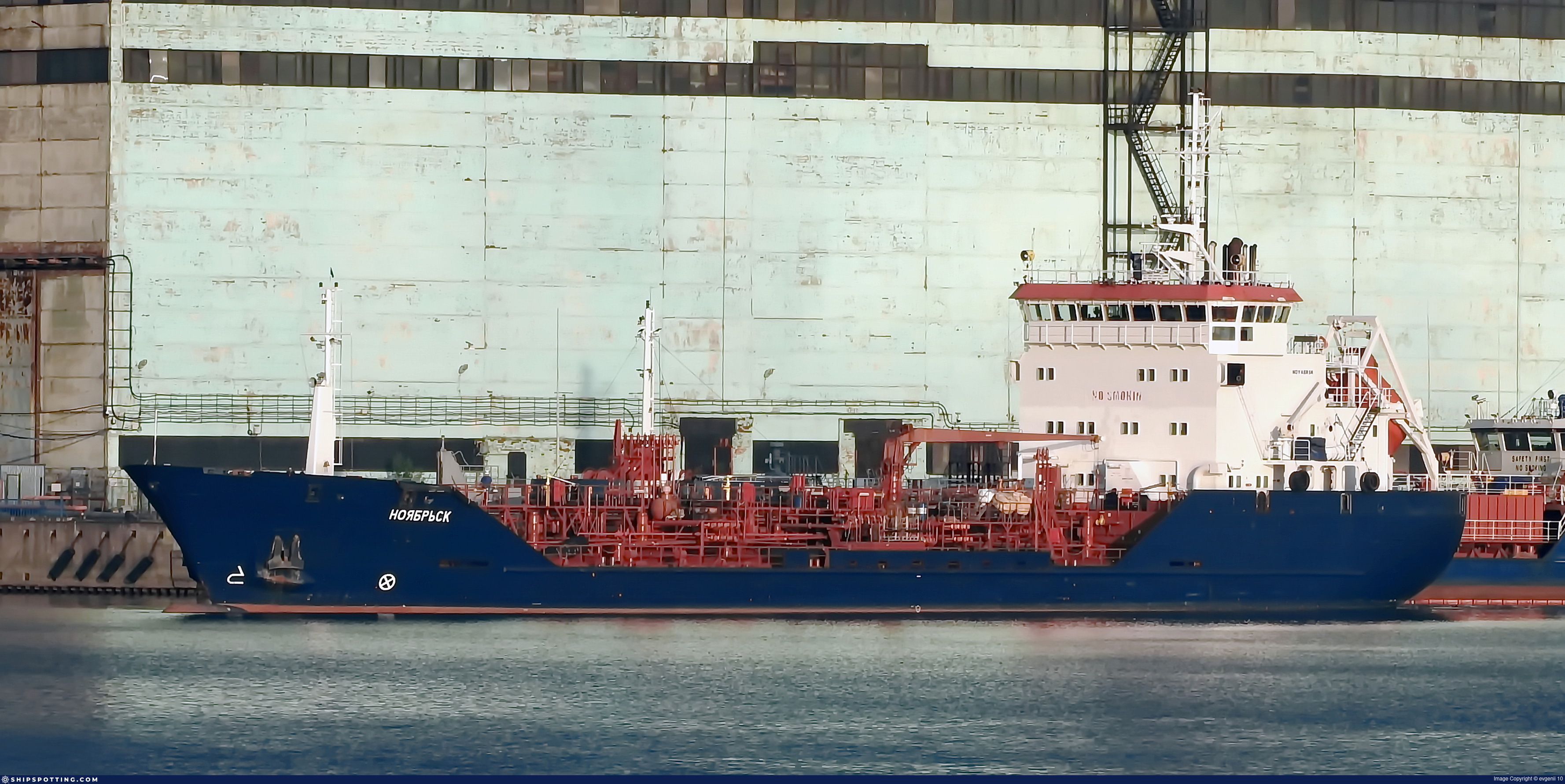
IMO 8915550
Vessel information
Sanctioned by
Company & Ownership
Management & Operations
Classification & Safety
Port State Control (PSC) Inspections
Programs & Notes
EU Russia Sanctions – Shadow Fleet | SEMA (Canada) — vessel designations
Vessel Changes
AIS Events
50 events detected • 16 zones • Last: Jun 10, 2026
- Zone: Kildin Strait LNG STS Zone
- Duration: 1h 46m
- Data Points: 10 AIS positions
- Period: 2026-06-10T10:11:20+00:00 to 2026-06-10T11:57:30+00:00
Show Raw Evidence JSON
{
    "zone_id": "russia_murmansk_sts",
    "zone_name": "Kildin Strait LNG STS Zone",
    "dwell_minutes": 106.2000000000000028421709430404007434844970703125,
    "points_in_zone": 10,
    "first_point": {
        "ts": "2026-06-10T10:11:20+00:00",
        "lat": 69.61687829999999621577444486320018768310546875,
        "lon": 33.5363882999999987077899277210235595703125
    },
    "last_point": {
        "ts": "2026-06-10T11:57:30+00:00",
        "lat": 69.3571400000000011232259566895663738250732421875,
        "lon": 33.5391283000000015590558177791535854339599609375
    }
}- Zone: Murmansk/Kola Bay Terminal
- Duration: 1h 46m
- Data Points: 10 AIS positions
- Period: 2026-06-10T10:11:20+00:00 to 2026-06-10T11:57:30+00:00
Show Raw Evidence JSON
{
    "zone_id": "russia_murmansk",
    "zone_name": "Murmansk\/Kola Bay Terminal",
    "dwell_minutes": 106.2000000000000028421709430404007434844970703125,
    "points_in_zone": 10,
    "first_point": {
        "ts": "2026-06-10T10:11:20+00:00",
        "lat": 69.61687829999999621577444486320018768310546875,
        "lon": 33.5363882999999987077899277210235595703125
    },
    "last_point": {
        "ts": "2026-06-10T11:57:30+00:00",
        "lat": 69.3571400000000011232259566895663738250732421875,
        "lon": 33.5391283000000015590558177791535854339599609375
    }
}- Zone: Kildin Strait LNG STS Zone
- Duration: 2h 39m
- Data Points: 18 AIS positions
- Period: 2026-06-10T09:18:18+00:00 to 2026-06-10T11:57:30+00:00
Show Raw Evidence JSON
{
    "zone_id": "russia_murmansk_sts",
    "zone_name": "Kildin Strait LNG STS Zone",
    "dwell_minutes": 159.19999999999998863131622783839702606201171875,
    "points_in_zone": 18,
    "first_point": {
        "ts": "2026-06-10T09:18:18+00:00",
        "lat": 69.7884317000000038433427107520401477813720703125,
        "lon": 33.53651330000000285735950456000864505767822265625
    },
    "last_point": {
        "ts": "2026-06-10T11:57:30+00:00",
        "lat": 69.3571400000000011232259566895663738250732421875,
        "lon": 33.5391283000000015590558177791535854339599609375
    }
}- Zone: Murmansk/Kola Bay Terminal
- Duration: 2h 56m
- Data Points: 23 AIS positions
- Period: 2026-06-10T09:01:00+00:00 to 2026-06-10T11:57:30+00:00
Show Raw Evidence JSON
{
    "zone_id": "russia_murmansk",
    "zone_name": "Murmansk\/Kola Bay Terminal",
    "dwell_minutes": 176.5,
    "points_in_zone": 23,
    "first_point": {
        "ts": "2026-06-10T09:01:00+00:00",
        "lat": 69.8456900000000047157300286926329135894775390625,
        "lon": 33.54254999999999853343979339115321636199951171875
    },
    "last_point": {
        "ts": "2026-06-10T11:57:30+00:00",
        "lat": 69.3571400000000011232259566895663738250732421875,
        "lon": 33.5391283000000015590558177791535854339599609375
    }
}- Zone: Murmansk/Kola Bay Terminal
- Duration: 3h 51m
- Data Points: 33 AIS positions
- Period: 2026-06-10T08:05:40+00:00 to 2026-06-10T11:57:30+00:00
Show Raw Evidence JSON
{
    "zone_id": "russia_murmansk",
    "zone_name": "Murmansk\/Kola Bay Terminal",
    "dwell_minutes": 231.80000000000001136868377216160297393798828125,
    "points_in_zone": 33,
    "first_point": {
        "ts": "2026-06-10T08:05:40+00:00",
        "lat": 69.9899817000000012967575457878410816192626953125,
        "lon": 33.25521669999999829769876669161021709442138671875
    },
    "last_point": {
        "ts": "2026-06-10T11:57:30+00:00",
        "lat": 69.3571400000000011232259566895663738250732421875,
        "lon": 33.5391283000000015590558177791535854339599609375
    }
}- Zone: Brittany Coast Surveillance Zone
- Duration: 1h 23m
- Data Points: 16 AIS positions
- Period: 2026-06-08T04:02:30+00:00 to 2026-06-08T05:25:38+00:00
Show Raw Evidence JSON
{
    "zone_id": "discovered_070",
    "zone_name": "Brittany Coast Surveillance Zone",
    "dwell_minutes": 83.099999999999994315658113919198513031005859375,
    "points_in_zone": 16,
    "first_point": {
        "ts": "2026-06-08T04:02:30+00:00",
        "lat": 67.5566299999999984038367983885109424591064453125,
        "lon": 9.375331700000000267891664407216012477874755859375
    },
    "last_point": {
        "ts": "2026-06-08T05:25:38+00:00",
        "lat": 67.8102832999999947105607134290039539337158203125,
        "lon": 9.6946150000000006485834092018194496631622314453125
    }
}- Zone: Brittany Coast Surveillance Zone
- Duration: 1h 38m
- Data Points: 18 AIS positions
- Period: 2026-06-08T03:47:29+00:00 to 2026-06-08T05:25:38+00:00
Show Raw Evidence JSON
{
    "zone_id": "discovered_070",
    "zone_name": "Brittany Coast Surveillance Zone",
    "dwell_minutes": 98.2000000000000028421709430404007434844970703125,
    "points_in_zone": 18,
    "first_point": {
        "ts": "2026-06-08T03:47:29+00:00",
        "lat": 67.5104199999999963210939313285052776336669921875,
        "lon": 9.315606700000000017780621419660747051239013671875
    },
    "last_point": {
        "ts": "2026-06-08T05:25:38+00:00",
        "lat": 67.8102832999999947105607134290039539337158203125,
        "lon": 9.6946150000000006485834092018194496631622314453125
    }
}- Zone: Norwegian Sea Sanctions Monitoring Zone
- Duration: 1h 21m
- Data Points: 13 AIS positions
- Period: 2026-06-07T09:12:09+00:00 to 2026-06-07T10:33:21+00:00
Show Raw Evidence JSON
{
    "zone_id": "discovered_129",
    "zone_name": "Norwegian Sea Sanctions Monitoring Zone",
    "dwell_minutes": 81.2000000000000028421709430404007434844970703125,
    "points_in_zone": 13,
    "first_point": {
        "ts": "2026-06-07T09:12:09+00:00",
        "lat": 64.1798450000000002546585164964199066162109375,
        "lon": 5.5134667000000003866944098263047635555267333984375
    },
    "last_point": {
        "ts": "2026-06-07T10:33:21+00:00",
        "lat": 64.4211432999999971116267261095345020294189453125,
        "lon": 5.76916329999999977218294588965363800525665283203125
    }
}- Zone: Norwegian Sea Sanctions Monitoring Zone
- Duration: 2h 31m
- Data Points: 23 AIS positions
- Period: 2026-06-07T08:02:00+00:00 to 2026-06-07T10:33:21+00:00
Show Raw Evidence JSON
{
    "zone_id": "discovered_129",
    "zone_name": "Norwegian Sea Sanctions Monitoring Zone",
    "dwell_minutes": 151.30000000000001136868377216160297393798828125,
    "points_in_zone": 23,
    "first_point": {
        "ts": "2026-06-07T08:02:00+00:00",
        "lat": 63.9617616999999967219991958700120449066162109375,
        "lon": 5.28185669999999962698211675160564482212066650390625
    },
    "last_point": {
        "ts": "2026-06-07T10:33:21+00:00",
        "lat": 64.4211432999999971116267261095345020294189453125,
        "lon": 5.76916329999999977218294588965363800525665283203125
    }
}- Zone: Norwegian Sea Sanctions Monitoring Zone
- Duration: 3h 30m
- Data Points: 38 AIS positions
- Period: 2026-06-07T07:02:59+00:00 to 2026-06-07T10:33:21+00:00
Show Raw Evidence JSON
{
    "zone_id": "discovered_129",
    "zone_name": "Norwegian Sea Sanctions Monitoring Zone",
    "dwell_minutes": 210.400000000000005684341886080801486968994140625,
    "points_in_zone": 38,
    "first_point": {
        "ts": "2026-06-07T07:02:59+00:00",
        "lat": 63.783850000000001045918907038867473602294921875,
        "lon": 5.09670169999999966847781251999549567699432373046875
    },
    "last_point": {
        "ts": "2026-06-07T10:33:21+00:00",
        "lat": 64.4211432999999971116267261095345020294189453125,
        "lon": 5.76916329999999977218294588965363800525665283203125
    }
}- Zone: Southern Baltic Surveillance Zone
- Duration: 1h 19m
- Data Points: 19 AIS positions
- Period: 2026-06-07T07:02:59+00:00 to 2026-06-07T08:22:49+00:00
Show Raw Evidence JSON
{
    "zone_id": "discovered_093",
    "zone_name": "Southern Baltic Surveillance Zone",
    "dwell_minutes": 79.7999999999999971578290569595992565155029296875,
    "points_in_zone": 19,
    "first_point": {
        "ts": "2026-06-07T07:02:59+00:00",
        "lat": 63.783850000000001045918907038867473602294921875,
        "lon": 5.09670169999999966847781251999549567699432373046875
    },
    "last_point": {
        "ts": "2026-06-07T08:22:49+00:00",
        "lat": 64.02674170000000231084413826465606689453125,
        "lon": 5.34859330000000010585381460259668529033660888671875
    }
}- Zone: Norwegian Sea Sanctions Monitoring Zone
- Duration: 4h 11m
- Data Points: 46 AIS positions
- Period: 2026-06-07T06:21:29+00:00 to 2026-06-07T10:33:21+00:00
Show Raw Evidence JSON
{
    "zone_id": "discovered_129",
    "zone_name": "Norwegian Sea Sanctions Monitoring Zone",
    "dwell_minutes": 251.900000000000005684341886080801486968994140625,
    "points_in_zone": 46,
    "first_point": {
        "ts": "2026-06-07T06:21:29+00:00",
        "lat": 63.662343300000003409877535887062549591064453125,
        "lon": 4.97377330000000039689211916993372142314910888671875
    },
    "last_point": {
        "ts": "2026-06-07T10:33:21+00:00",
        "lat": 64.4211432999999971116267261095345020294189453125,
        "lon": 5.76916329999999977218294588965363800525665283203125
    }
}- Zone: Southern Baltic Surveillance Zone
- Duration: 2h 18m
- Data Points: 31 AIS positions
- Period: 2026-06-07T06:04:50+00:00 to 2026-06-07T08:22:49+00:00
Show Raw Evidence JSON
{
    "zone_id": "discovered_093",
    "zone_name": "Southern Baltic Surveillance Zone",
    "dwell_minutes": 138,
    "points_in_zone": 31,
    "first_point": {
        "ts": "2026-06-07T06:04:50+00:00",
        "lat": 63.61257330000000109748725662939250469207763671875,
        "lon": 4.9286417000000000143700162880122661590576171875
    },
    "last_point": {
        "ts": "2026-06-07T08:22:49+00:00",
        "lat": 64.02674170000000231084413826465606689453125,
        "lon": 5.34859330000000010585381460259668529033660888671875
    }
}- Zone: Southern Baltic Surveillance Zone
- Duration: 3h 12m
- Data Points: 41 AIS positions
- Period: 2026-06-07T05:10:29+00:00 to 2026-06-07T08:22:49+00:00
Show Raw Evidence JSON
{
    "zone_id": "discovered_093",
    "zone_name": "Southern Baltic Surveillance Zone",
    "dwell_minutes": 192.30000000000001136868377216160297393798828125,
    "points_in_zone": 41,
    "first_point": {
        "ts": "2026-06-07T05:10:29+00:00",
        "lat": 63.45606500000000238514985539950430393218994140625,
        "lon": 4.74923499999999965126562528894282877445220947265625
    },
    "last_point": {
        "ts": "2026-06-07T08:22:49+00:00",
        "lat": 64.02674170000000231084413826465606689453125,
        "lon": 5.34859330000000010585381460259668529033660888671875
    }
}- Zone: discovered_027
- Duration: 1h 44m
- Data Points: 20 AIS positions
- Period: 2026-06-05T14:03:19+00:00 to 2026-06-05T15:47:29+00:00
Show Raw Evidence JSON
{
    "zone_id": "discovered_027",
    "zone_name": "Baltic Sea Sanctioned Vessel Zone",
    "dwell_minutes": 104.2000000000000028421709430404007434844970703125,
    "points_in_zone": 20,
    "first_point": {
        "ts": "2026-06-05T14:03:19+00:00",
        "lat": 57.86006830000000178415575646795332431793212890625,
        "lon": 9.3697867000000005788251655758358538150787353515625
    },
    "last_point": {
        "ts": "2026-06-05T15:47:29+00:00",
        "lat": 57.86269329999999655456122127361595630645751953125,
        "lon": 8.77236669999999918445610092021524906158447265625
    }
}- Zone: discovered_027
- Duration: 2h 12m
- Data Points: 24 AIS positions
- Period: 2026-06-05T13:34:49+00:00 to 2026-06-05T15:47:29+00:00
Show Raw Evidence JSON
{
    "zone_id": "discovered_027",
    "zone_name": "Baltic Sea Sanctioned Vessel Zone",
    "dwell_minutes": 132.69999999999998863131622783839702606201171875,
    "points_in_zone": 24,
    "first_point": {
        "ts": "2026-06-05T13:34:49+00:00",
        "lat": 57.86093329999999923529685474932193756103515625,
        "lon": 9.5291116999999996295400706003420054912567138671875
    },
    "last_point": {
        "ts": "2026-06-05T15:47:29+00:00",
        "lat": 57.86269329999999655456122127361595630645751953125,
        "lon": 8.77236669999999918445610092021524906158447265625
    }
}- Zone: North Sea Surveillance Zone
- Duration: 1h 23m
- Data Points: 14 AIS positions
- Period: 2026-06-05T13:02:40+00:00 to 2026-06-05T14:26:20+00:00
Show Raw Evidence JSON
{
    "zone_id": "discovered_128",
    "zone_name": "North Sea Surveillance Zone",
    "dwell_minutes": 83.7000000000000028421709430404007434844970703125,
    "points_in_zone": 14,
    "first_point": {
        "ts": "2026-06-05T13:02:40+00:00",
        "lat": 57.86056669999999968467818689532577991485595703125,
        "lon": 9.705826699999999362944436143152415752410888671875
    },
    "last_point": {
        "ts": "2026-06-05T14:26:20+00:00",
        "lat": 57.8609866999999979952917783521115779876708984375,
        "lon": 9.2407850000000006929212759132497012615203857421875
    }
}- Zone: North Sea Surveillance Zone
- Duration: 1h 40m
- Data Points: 16 AIS positions
- Period: 2026-06-05T12:46:09+00:00 to 2026-06-05T14:26:20+00:00
Show Raw Evidence JSON
{
    "zone_id": "discovered_128",
    "zone_name": "North Sea Surveillance Zone",
    "dwell_minutes": 100.2000000000000028421709430404007434844970703125,
    "points_in_zone": 16,
    "first_point": {
        "ts": "2026-06-05T12:46:09+00:00",
        "lat": 57.86209000000000202135197469033300876617431640625,
        "lon": 9.796926700000000209911377169191837310791015625
    },
    "last_point": {
        "ts": "2026-06-05T14:26:20+00:00",
        "lat": 57.8609866999999979952917783521115779876708984375,
        "lon": 9.2407850000000006929212759132497012615203857421875
    }
}- Zone: Danish Straits/Skagerrak
- Duration: 1h 37m
- Data Points: 51 AIS positions
- Period: 2026-06-05T08:01:08+00:00 to 2026-06-05T09:38:48+00:00
Show Raw Evidence JSON
{
    "zone_id": "osint_danish_straits",
    "zone_name": "Danish Straits\/Skagerrak",
    "dwell_minutes": 97.7000000000000028421709430404007434844970703125,
    "points_in_zone": 51,
    "first_point": {
        "ts": "2026-06-05T08:01:08+00:00",
        "lat": 57.62540829999999658639353583566844463348388671875,
        "lon": 11.233566700000000793124854681082069873809814453125
    },
    "last_point": {
        "ts": "2026-06-05T09:38:48+00:00",
        "lat": 57.855424999999996771293808706104755401611328125,
        "lon": 10.8464650000000002449951352900825440883636474609375
    }
}- Zone: Danish Straits/Skagerrak
- Duration: 2h 38m
- Data Points: 90 AIS positions
- Period: 2026-06-05T07:00:09+00:00 to 2026-06-05T09:38:48+00:00
Show Raw Evidence JSON
{
    "zone_id": "osint_danish_straits",
    "zone_name": "Danish Straits\/Skagerrak",
    "dwell_minutes": 158.69999999999998863131622783839702606201171875,
    "points_in_zone": 90,
    "first_point": {
        "ts": "2026-06-05T07:00:09+00:00",
        "lat": 57.47021670000000170830389834009110927581787109375,
        "lon": 11.4722899999999992104449120233766734600067138671875
    },
    "last_point": {
        "ts": "2026-06-05T09:38:48+00:00",
        "lat": 57.855424999999996771293808706104755401611328125,
        "lon": 10.8464650000000002449951352900825440883636474609375
    }
}- Zone: Danish Straits/Skagerrak
- Duration: 3h 34m
- Data Points: 116 AIS positions
- Period: 2026-06-05T06:04:38+00:00 to 2026-06-05T09:38:48+00:00
Show Raw Evidence JSON
{
    "zone_id": "osint_danish_straits",
    "zone_name": "Danish Straits\/Skagerrak",
    "dwell_minutes": 214.19999999999998863131622783839702606201171875,
    "points_in_zone": 116,
    "first_point": {
        "ts": "2026-06-05T06:04:38+00:00",
        "lat": 57.28820329999999927395037957467138767242431640625,
        "lon": 11.566153299999999859437593840993940830230712890625
    },
    "last_point": {
        "ts": "2026-06-05T09:38:48+00:00",
        "lat": 57.855424999999996771293808706104755401611328125,
        "lon": 10.8464650000000002449951352900825440883636474609375
    }
}- Zone: Danish Straits/Skagerrak
- Duration: 4h 36m
- Data Points: 149 AIS positions
- Period: 2026-06-05T05:02:19+00:00 to 2026-06-05T09:38:48+00:00
Show Raw Evidence JSON
{
    "zone_id": "osint_danish_straits",
    "zone_name": "Danish Straits\/Skagerrak",
    "dwell_minutes": 276.5,
    "points_in_zone": 149,
    "first_point": {
        "ts": "2026-06-05T05:02:19+00:00",
        "lat": 57.0970032999999972389559843577444553375244140625,
        "lon": 11.698081699999999472083800355903804302215576171875
    },
    "last_point": {
        "ts": "2026-06-05T09:38:48+00:00",
        "lat": 57.855424999999996771293808706104755401611328125,
        "lon": 10.8464650000000002449951352900825440883636474609375
    }
}- Zone: Danish Straits/Skagerrak
- Duration: 4h 54m
- Data Points: 158 AIS positions
- Period: 2026-06-05T04:44:19+00:00 to 2026-06-05T09:38:48+00:00
Show Raw Evidence JSON
{
    "zone_id": "osint_danish_straits",
    "zone_name": "Danish Straits\/Skagerrak",
    "dwell_minutes": 294.5,
    "points_in_zone": 158,
    "first_point": {
        "ts": "2026-06-05T04:44:19+00:00",
        "lat": 57.042276700000002165324985980987548828125,
        "lon": 11.73780670000000014852048479951918125152587890625
    },
    "last_point": {
        "ts": "2026-06-05T09:38:48+00:00",
        "lat": 57.855424999999996771293808706104755401611328125,
        "lon": 10.8464650000000002449951352900825440883636474609375
    }
}- Zone: Eastern Zealand Monitoring Zone
- Duration: 1h 30m
- Data Points: 42 AIS positions
- Period: 2026-06-04T18:00:59+00:00 to 2026-06-04T19:31:00+00:00
Show Raw Evidence JSON
{
    "zone_id": "discovered_089",
    "zone_name": "Eastern Zealand Monitoring Zone",
    "dwell_minutes": 90,
    "points_in_zone": 42,
    "first_point": {
        "ts": "2026-06-04T18:00:59+00:00",
        "lat": 55.05093000000000103000274975784122943878173828125,
        "lon": 11.03692170000000061236278270371258258819580078125
    },
    "last_point": {
        "ts": "2026-06-04T19:31:00+00:00",
        "lat": 55.36572670000000329082467942498624324798583984375,
        "lon": 11.041128300000000450609149993397295475006103515625
    }
}- Zone: Eastern Zealand Monitoring Zone
- Duration: 1h 47m
- Data Points: 54 AIS positions
- Period: 2026-06-04T17:43:25+00:00 to 2026-06-04T19:31:00+00:00
Show Raw Evidence JSON
{
    "zone_id": "discovered_089",
    "zone_name": "Eastern Zealand Monitoring Zone",
    "dwell_minutes": 107.599999999999994315658113919198513031005859375,
    "points_in_zone": 54,
    "first_point": {
        "ts": "2026-06-04T17:43:25+00:00",
        "lat": 54.988321700000000191721483133733272552490234375,
        "lon": 11.0229750000000006338041202980093657970428466796875
    },
    "last_point": {
        "ts": "2026-06-04T19:31:00+00:00",
        "lat": 55.36572670000000329082467942498624324798583984375,
        "lon": 11.041128300000000450609149993397295475006103515625
    }
}- Zone: Alboran Sea Surveillance Zone
- Duration: 1h 4m
- Data Points: 42 AIS positions
- Period: 2026-06-04T13:00:19+00:00 to 2026-06-04T14:04:39+00:00
Show Raw Evidence JSON
{
    "zone_id": "discovered_103",
    "zone_name": "Alboran Sea Surveillance Zone",
    "dwell_minutes": 64.2999999999999971578290569595992565155029296875,
    "points_in_zone": 42,
    "first_point": {
        "ts": "2026-06-04T13:00:19+00:00",
        "lat": 54.4455549999999988131094141863286495208740234375,
        "lon": 11.9713300000000000267164068645797669887542724609375
    },
    "last_point": {
        "ts": "2026-06-04T14:04:39+00:00",
        "lat": 54.47920669999999887522790231741964817047119140625,
        "lon": 11.6170182999999997974782672827132046222686767578125
    }
}- Zone: Alboran Sea Surveillance Zone
- Duration: 1h 51m
- Data Points: 66 AIS positions
- Period: 2026-06-04T12:13:18+00:00 to 2026-06-04T14:04:39+00:00
Show Raw Evidence JSON
{
    "zone_id": "discovered_103",
    "zone_name": "Alboran Sea Surveillance Zone",
    "dwell_minutes": 111.2999999999999971578290569595992565155029296875,
    "points_in_zone": 66,
    "first_point": {
        "ts": "2026-06-04T12:13:18+00:00",
        "lat": 54.4960267000000015968907973729074001312255859375,
        "lon": 12.1831466999999999956116880639456212520599365234375
    },
    "last_point": {
        "ts": "2026-06-04T14:04:39+00:00",
        "lat": 54.47920669999999887522790231741964817047119140625,
        "lon": 11.6170182999999997974782672827132046222686767578125
    }
}- Zone: discovered_072
- Duration: 2h 10m
- Data Points: 7 AIS positions
- Period: 2026-06-03T09:03:59+00:00 to 2026-06-03T11:14:18+00:00
Show Raw Evidence JSON
{
    "zone_id": "discovered_072",
    "zone_name": "Brittany Channel Surveillance Zone",
    "dwell_minutes": 130.30000000000001136868377216160297393798828125,
    "points_in_zone": 7,
    "first_point": {
        "ts": "2026-06-03T09:03:59+00:00",
        "lat": 57.07501500000000049794834922067821025848388671875,
        "lon": 19.452723299999998829434844083152711391448974609375
    },
    "last_point": {
        "ts": "2026-06-03T11:14:18+00:00",
        "lat": 56.7054499999999990222931955941021442413330078125,
        "lon": 19.080414999999998570956449839286506175994873046875
    }
}- Zone: discovered_072
- Duration: 3h 12m
- Data Points: 21 AIS positions
- Period: 2026-06-03T08:01:58+00:00 to 2026-06-03T11:14:18+00:00
Show Raw Evidence JSON
{
    "zone_id": "discovered_072",
    "zone_name": "Brittany Channel Surveillance Zone",
    "dwell_minutes": 192.30000000000001136868377216160297393798828125,
    "points_in_zone": 21,
    "first_point": {
        "ts": "2026-06-03T08:01:58+00:00",
        "lat": 57.25297830000000232075763051398098468780517578125,
        "lon": 19.625093299999999629790181643329560756683349609375
    },
    "last_point": {
        "ts": "2026-06-03T11:14:18+00:00",
        "lat": 56.7054499999999990222931955941021442413330078125,
        "lon": 19.080414999999998570956449839286506175994873046875
    }
}- Zone: discovered_072
- Duration: 3h 50m
- Data Points: 31 AIS positions
- Period: 2026-06-03T07:23:48+00:00 to 2026-06-03T11:14:18+00:00
Show Raw Evidence JSON
{
    "zone_id": "discovered_072",
    "zone_name": "Brittany Channel Surveillance Zone",
    "dwell_minutes": 230.5,
    "points_in_zone": 31,
    "first_point": {
        "ts": "2026-06-03T07:23:48+00:00",
        "lat": 57.3663099999999985811882652342319488525390625,
        "lon": 19.743369999999998753992258571088314056396484375
    },
    "last_point": {
        "ts": "2026-06-03T11:14:18+00:00",
        "lat": 56.7054499999999990222931955941021442413330078125,
        "lon": 19.080414999999998570956449839286506175994873046875
    }
}- Zone: discovered_072
- Duration: 5h 8m
- Data Points: 40 AIS positions
- Period: 2026-06-03T06:05:40+00:00 to 2026-06-03T11:14:18+00:00
Show Raw Evidence JSON
{
    "zone_id": "discovered_072",
    "zone_name": "Brittany Channel Surveillance Zone",
    "dwell_minutes": 308.6000000000000227373675443232059478759765625,
    "points_in_zone": 40,
    "first_point": {
        "ts": "2026-06-03T06:05:40+00:00",
        "lat": 57.6074432999999999083229340612888336181640625,
        "lon": 19.93927000000000049340087571181356906890869140625
    },
    "last_point": {
        "ts": "2026-06-03T11:14:18+00:00",
        "lat": 56.7054499999999990222931955941021442413330078125,
        "lon": 19.080414999999998570956449839286506175994873046875
    }
}- Zone: discovered_072
- Duration: 6h 9m
- Data Points: 62 AIS positions
- Period: 2026-06-03T05:04:39+00:00 to 2026-06-03T11:14:18+00:00
Show Raw Evidence JSON
{
    "zone_id": "discovered_072",
    "zone_name": "Brittany Channel Surveillance Zone",
    "dwell_minutes": 369.6000000000000227373675443232059478759765625,
    "points_in_zone": 62,
    "first_point": {
        "ts": "2026-06-03T05:04:39+00:00",
        "lat": 57.7958416999999968766132951714098453521728515625,
        "lon": 20.093386699999999933652361505664885044097900390625
    },
    "last_point": {
        "ts": "2026-06-03T11:14:18+00:00",
        "lat": 56.7054499999999990222931955941021442413330078125,
        "lon": 19.080414999999998570956449839286506175994873046875
    }
}- Zone: Eastern Mediterranean Monitoring Zone
- Duration: 1h 20m
- Data Points: 24 AIS positions
- Period: 2026-06-03T04:00:58+00:00 to 2026-06-03T05:21:38+00:00
Show Raw Evidence JSON
{
    "zone_id": "discovered_090",
    "zone_name": "Eastern Mediterranean Monitoring Zone",
    "dwell_minutes": 80.7000000000000028421709430404007434844970703125,
    "points_in_zone": 24,
    "first_point": {
        "ts": "2026-06-03T04:00:58+00:00",
        "lat": 57.992085000000002992237568832933902740478515625,
        "lon": 20.254383300000000645013642497360706329345703125
    },
    "last_point": {
        "ts": "2026-06-03T05:21:38+00:00",
        "lat": 57.7428967000000028519934858195483684539794921875,
        "lon": 20.05338499999999868350641918368637561798095703125
    }
}- Zone: discovered_072
- Duration: 6h 32m
- Data Points: 67 AIS positions
- Period: 2026-06-03T04:41:38+00:00 to 2026-06-03T11:14:18+00:00
Show Raw Evidence JSON
{
    "zone_id": "discovered_072",
    "zone_name": "Brittany Channel Surveillance Zone",
    "dwell_minutes": 392.69999999999998863131622783839702606201171875,
    "points_in_zone": 67,
    "first_point": {
        "ts": "2026-06-03T04:41:38+00:00",
        "lat": 57.866590000000002191882231272757053375244140625,
        "lon": 20.151166700000000986392478807829320430755615234375
    },
    "last_point": {
        "ts": "2026-06-03T11:14:18+00:00",
        "lat": 56.7054499999999990222931955941021442413330078125,
        "lon": 19.080414999999998570956449839286506175994873046875
    }
}- Zone: Eastern Mediterranean Monitoring Zone
- Duration: 1h 30m
- Data Points: 26 AIS positions
- Period: 2026-06-03T03:51:38+00:00 to 2026-06-03T05:21:38+00:00
Show Raw Evidence JSON
{
    "zone_id": "discovered_090",
    "zone_name": "Eastern Mediterranean Monitoring Zone",
    "dwell_minutes": 90,
    "points_in_zone": 26,
    "first_point": {
        "ts": "2026-06-03T03:51:38+00:00",
        "lat": 58.0202416999999996960468706674873828887939453125,
        "lon": 20.2806183000000004312823875807225704193115234375
    },
    "last_point": {
        "ts": "2026-06-03T05:21:38+00:00",
        "lat": 57.7428967000000028519934858195483684539794921875,
        "lon": 20.05338499999999868350641918368637561798095703125
    }
}- Gap Duration: 6h 29m
- Last Seen: 2026-06-02T21:21:59+00:00 at 59.1213, 21.5912 (Zone: Archipelago Sea Surveillance Zone)
- Next Seen: 2026-06-03T03:51:38+00:00 at 58.0202, 20.2806
🛰️ Gap Corroboration
These are snapshots that may corroborate presence during the gap. They do not reconstruct a continuous route.
SAR Imagery (Sentinel-1)
Status: ✓ Snapshot available
SAR snapshot available for review
Scene: S1C_IW_GRDH_1SDV_20260602T160405_20260602T160430_007929_0101F2_1475_COG • Time: 2026-06-02T16:04:05.491584Z
SAR coverage thumbnail
VIIRS Thermal Anomaly
Status: ✗ No detections
No VIIRS thermal/light detections in corridor
Show Raw Evidence JSON
{
    "gap_minutes": 389.6000000000000227373675443232059478759765625,
    "last_seen": {
        "ts": "2026-06-02T21:21:59+00:00",
        "lat": 59.12127670000000279060259344987571239471435546875,
        "lon": 21.591248300000000170939529198221862316131591796875,
        "sog": 12.0999999999999996447286321199499070644378662109375,
        "zone_id": "discovered_006"
    },
    "next_seen": {
        "ts": "2026-06-03T03:51:38+00:00",
        "lat": 58.0202416999999996960468706674873828887939453125,
        "lon": 20.2806183000000004312823875807225704193115234375,
        "zone_ids": [
            "discovered_090"
        ]
    },
    "gap_enrichment": {
        "status": "done",
        "corridor": {
            "start": {
                "lat": 59.12127670000000279060259344987571239471435546875,
                "lon": 21.591248300000000170939529198221862316131591796875,
                "ts": "2026-06-02T21:21:59+00:00"
            },
            "end": {
                "lat": 58.0202416999999996960468706674873828887939453125,
                "lon": 20.2806183000000004312823875807225704193115234375,
                "ts": "2026-06-03T03:51:38+00:00"
            },
            "bbox": {
                "min_lat": 57.8400620000000031950548873282968997955322265625,
                "min_lon": 19.935078000000000741920302971266210079193115234375,
                "max_lat": 59.301456999999999197825673036277294158935546875,
                "max_lon": 21.93678799999999995407051756046712398529052734375
            },
            "buffer_km": 20
        },
        "sar": {
            "status": "snapshot",
            "scene_id": "S1C_IW_GRDH_1SDV_20260602T160405_20260602T160430_007929_0101F2_1475_COG",
            "scene_time": "2026-06-02T16:04:05.491584Z",
            "platform": "sentinel-1c",
            "assets": {
                "preview_url": "https:\/\/fleetleaks.com\/wp-content\/uploads\/fleetleaks-evidence\/sar-imagery\/2026\/06\/event_661457_thumbnail_20260603041506.png",
                "stored_path": "\/home\/fleetleaks\/public_html\/wp-content\/uploads\/fleetleaks-evidence\/sar-imagery\/2026\/06\/event_661457_thumbnail_20260603041506.png",
                "source": "copernicus_dataspace"
            },
            "notes": "SAR snapshot available for review"
        },
        "viirs": {
            "status": "not_found",
            "notes": "No VIIRS thermal\/light detections in corridor"
        },
        "searched_at": "2026-06-03T04:15:01.294628+00:00"
    }
}- Zone: Archipelago Sea Surveillance Zone
- Duration: 1h 21m
- Data Points: 59 AIS positions
- Period: 2026-06-02T20:00:19+00:00 to 2026-06-02T21:21:59+00:00
Show Raw Evidence JSON
{
    "zone_id": "discovered_006",
    "zone_name": "Archipelago Sea Surveillance Zone",
    "dwell_minutes": 81.7000000000000028421709430404007434844970703125,
    "points_in_zone": 59,
    "first_point": {
        "ts": "2026-06-02T20:00:19+00:00",
        "lat": 59.303938299999998662315192632377147674560546875,
        "lon": 21.988951700000001210355549119412899017333984375
    },
    "last_point": {
        "ts": "2026-06-02T21:21:59+00:00",
        "lat": 59.12127670000000279060259344987571239471435546875,
        "lon": 21.591248300000000170939529198221862316131591796875
    }
}- Zone: Archipelago Sea Surveillance Zone
- Duration: 2h 20m
- Data Points: 93 AIS positions
- Period: 2026-06-02T19:01:30+00:00 to 2026-06-02T21:21:59+00:00
Show Raw Evidence JSON
{
    "zone_id": "discovered_006",
    "zone_name": "Archipelago Sea Surveillance Zone",
    "dwell_minutes": 140.5,
    "points_in_zone": 93,
    "first_point": {
        "ts": "2026-06-02T19:01:30+00:00",
        "lat": 59.42572830000000294603523798286914825439453125,
        "lon": 22.294283300000000025420376914553344249725341796875
    },
    "last_point": {
        "ts": "2026-06-02T21:21:59+00:00",
        "lat": 59.12127670000000279060259344987571239471435546875,
        "lon": 21.591248300000000170939529198221862316131591796875
    }
}- Zone: Archipelago Sea Surveillance Zone
- Duration: 3h 21m
- Data Points: 130 AIS positions
- Period: 2026-06-02T18:00:29+00:00 to 2026-06-02T21:21:59+00:00
Show Raw Evidence JSON
{
    "zone_id": "discovered_006",
    "zone_name": "Archipelago Sea Surveillance Zone",
    "dwell_minutes": 201.5,
    "points_in_zone": 130,
    "first_point": {
        "ts": "2026-06-02T18:00:29+00:00",
        "lat": 59.5314783000000034007825888693332672119140625,
        "lon": 22.63043830000000156132955453358590602874755859375
    },
    "last_point": {
        "ts": "2026-06-02T21:21:59+00:00",
        "lat": 59.12127670000000279060259344987571239471435546875,
        "lon": 21.591248300000000170939529198221862316131591796875
    }
}- Zone: Archipelago Sea Surveillance Zone
- Duration: 4h 21m
- Data Points: 160 AIS positions
- Period: 2026-06-02T17:00:29+00:00 to 2026-06-02T21:21:59+00:00
Show Raw Evidence JSON
{
    "zone_id": "discovered_006",
    "zone_name": "Archipelago Sea Surveillance Zone",
    "dwell_minutes": 261.5,
    "points_in_zone": 160,
    "first_point": {
        "ts": "2026-06-02T17:00:29+00:00",
        "lat": 59.58243999999999829242369742132723331451416015625,
        "lon": 23.009595000000000908357833395712077617645263671875
    },
    "last_point": {
        "ts": "2026-06-02T21:21:59+00:00",
        "lat": 59.12127670000000279060259344987571239471435546875,
        "lon": 21.591248300000000170939529198221862316131591796875
    }
}- Zone: Archipelago Sea Surveillance Zone
- Duration: 5h 20m
- Data Points: 191 AIS positions
- Period: 2026-06-02T16:01:08+00:00 to 2026-06-02T21:21:59+00:00
Show Raw Evidence JSON
{
    "zone_id": "discovered_006",
    "zone_name": "Archipelago Sea Surveillance Zone",
    "dwell_minutes": 320.8999999999999772626324556767940521240234375,
    "points_in_zone": 191,
    "first_point": {
        "ts": "2026-06-02T16:01:08+00:00",
        "lat": 59.6344849999999979672793415375053882598876953125,
        "lon": 23.384273300000000261888999375514686107635498046875
    },
    "last_point": {
        "ts": "2026-06-02T21:21:59+00:00",
        "lat": 59.12127670000000279060259344987571239471435546875,
        "lon": 21.591248300000000170939529198221862316131591796875
    }
}- Zone: Archipelago Sea Surveillance Zone
- Duration: 5h 50m
- Data Points: 206 AIS positions
- Period: 2026-06-02T15:31:39+00:00 to 2026-06-02T21:21:59+00:00
Show Raw Evidence JSON
{
    "zone_id": "discovered_006",
    "zone_name": "Archipelago Sea Surveillance Zone",
    "dwell_minutes": 350.30000000000001136868377216160297393798828125,
    "points_in_zone": 206,
    "first_point": {
        "ts": "2026-06-02T15:31:39+00:00",
        "lat": 59.661619999999999208739609457552433013916015625,
        "lon": 23.571728300000000189129423233680427074432373046875
    },
    "last_point": {
        "ts": "2026-06-02T21:21:59+00:00",
        "lat": 59.12127670000000279060259344987571239471435546875,
        "lon": 21.591248300000000170939529198221862316131591796875
    }
}- Zone: Central Mediterranean Surveillance Zone
- Duration: 1h 11m
- Data Points: 44 AIS positions
- Period: 2026-06-02T13:01:29+00:00 to 2026-06-02T14:12:28+00:00
Show Raw Evidence JSON
{
    "zone_id": "discovered_130",
    "zone_name": "Central Mediterranean Surveillance Zone",
    "dwell_minutes": 71,
    "points_in_zone": 44,
    "first_point": {
        "ts": "2026-06-02T13:01:29+00:00",
        "lat": 59.79321999999999803776518092490732669830322265625,
        "lon": 24.528559999999998808561940677464008331298828125
    },
    "last_point": {
        "ts": "2026-06-02T14:12:28+00:00",
        "lat": 59.73200829999999683650457882322371006011962890625,
        "lon": 24.079256699999998403427525772713124752044677734375
    }
}- Zone: Baltic Exit/Tallinn Approach
- Duration: 1h 18m
- Data Points: 46 AIS positions
- Period: 2026-06-02T11:00:20+00:00 to 2026-06-02T12:18:18+00:00
Show Raw Evidence JSON
{
    "zone_id": "russia_baltic_transit",
    "zone_name": "Baltic Exit\/Tallinn Approach",
    "dwell_minutes": 78,
    "points_in_zone": 46,
    "first_point": {
        "ts": "2026-06-02T11:00:20+00:00",
        "lat": 59.8811299999999988585841492749750614166259765625,
        "lon": 25.289301699999999328838384826667606830596923828125
    },
    "last_point": {
        "ts": "2026-06-02T12:18:18+00:00",
        "lat": 59.8264300000000019963408703915774822235107421875,
        "lon": 24.80222499999999996589394868351519107818603515625
    }
}- Zone: Baltic Exit/Tallinn Approach
- Duration: 2h 17m
- Data Points: 78 AIS positions
- Period: 2026-06-02T10:00:29+00:00 to 2026-06-02T12:18:18+00:00
Show Raw Evidence JSON
{
    "zone_id": "russia_baltic_transit",
    "zone_name": "Baltic Exit\/Tallinn Approach",
    "dwell_minutes": 137.80000000000001136868377216160297393798828125,
    "points_in_zone": 78,
    "first_point": {
        "ts": "2026-06-02T10:00:29+00:00",
        "lat": 59.90762500000000301270119962282478809356689453125,
        "lon": 25.679378299999999768488123663701117038726806640625
    },
    "last_point": {
        "ts": "2026-06-02T12:18:18+00:00",
        "lat": 59.8264300000000019963408703915774822235107421875,
        "lon": 24.80222499999999996589394868351519107818603515625
    }
}- Zone: Baltic Exit/Tallinn Approach
- Duration: 3h 18m
- Data Points: 100 AIS positions
- Period: 2026-06-02T09:00:18+00:00 to 2026-06-02T12:18:18+00:00
Show Raw Evidence JSON
{
    "zone_id": "russia_baltic_transit",
    "zone_name": "Baltic Exit\/Tallinn Approach",
    "dwell_minutes": 198,
    "points_in_zone": 100,
    "first_point": {
        "ts": "2026-06-02T09:00:18+00:00",
        "lat": 59.9553216999999989411662681959569454193115234375,
        "lon": 26.062908300000000139107214636169373989105224609375
    },
    "last_point": {
        "ts": "2026-06-02T12:18:18+00:00",
        "lat": 59.8264300000000019963408703915774822235107421875,
        "lon": 24.80222499999999996589394868351519107818603515625
    }
}- Zone: Baltic Exit/Tallinn Approach
- Duration: 4h 17m
- Data Points: 119 AIS positions
- Period: 2026-06-02T08:01:18+00:00 to 2026-06-02T12:18:18+00:00
Show Raw Evidence JSON
{
    "zone_id": "russia_baltic_transit",
    "zone_name": "Baltic Exit\/Tallinn Approach",
    "dwell_minutes": 257,
    "points_in_zone": 119,
    "first_point": {
        "ts": "2026-06-02T08:01:18+00:00",
        "lat": 60.00544500000000169848135556094348430633544921875,
        "lon": 26.436250000000001136868377216160297393798828125
    },
    "last_point": {
        "ts": "2026-06-02T12:18:18+00:00",
        "lat": 59.8264300000000019963408703915774822235107421875,
        "lon": 24.80222499999999996589394868351519107818603515625
    }
}- Zone: Baltic Exit/Tallinn Approach
- Duration: 4h 18m
- Data Points: 120 AIS positions
- Period: 2026-06-02T07:59:28+00:00 to 2026-06-02T12:18:18+00:00
Show Raw Evidence JSON
{
    "zone_id": "russia_baltic_transit",
    "zone_name": "Baltic Exit\/Tallinn Approach",
    "dwell_minutes": 258.80000000000001136868377216160297393798828125,
    "points_in_zone": 120,
    "first_point": {
        "ts": "2026-06-02T07:59:28+00:00",
        "lat": 60.007018299999998589555616490542888641357421875,
        "lon": 26.447671700000000782893039286136627197265625
    },
    "last_point": {
        "ts": "2026-06-02T12:18:18+00:00",
        "lat": 59.8264300000000019963408703915774822235107421875,
        "lon": 24.80222499999999996589394868351519107818603515625
    }
}- Gap Duration: 5h 2m
- Last Seen: 2026-06-02T02:56:58+00:00 at 57.6619, 32.5301 (Zone: Central Baltic Sea Monitoring Zone)
- Next Seen: 2026-06-02T07:59:28+00:00 at 60.0070, 26.4477
🛰️ Gap Corroboration
These are snapshots that may corroborate presence during the gap. They do not reconstruct a continuous route.
SAR Imagery (Sentinel-1)
Status: ✓ Snapshot available
SAR snapshot available for review
Scene: S1D_IW_GRDH_1SDV_20260602T040907_20260602T040932_003052_005451_76C0_COG • Time: 2026-06-02T04:09:07.412506Z
SAR coverage thumbnail
VIIRS Thermal Anomaly
Status: ✗ No detections
No VIIRS thermal/light detections in corridor
Show Raw Evidence JSON
{
    "gap_minutes": 302.5,
    "last_seen": {
        "ts": "2026-06-02T02:56:58+00:00",
        "lat": 57.66187330000000343943611369468271732330322265625,
        "lon": 32.53005499999999727833710494451224803924560546875,
        "sog": 75.599999999999994315658113919198513031005859375,
        "zone_id": "discovered_148"
    },
    "next_seen": {
        "ts": "2026-06-02T07:59:28+00:00",
        "lat": 60.007018299999998589555616490542888641357421875,
        "lon": 26.447671700000000782893039286136627197265625,
        "zone_ids": [
            "russia_baltic_transit"
        ]
    },
    "gap_enrichment": {
        "status": "done",
        "corridor": {
            "start": {
                "lat": 57.66187330000000343943611369468271732330322265625,
                "lon": 32.53005499999999727833710494451224803924560546875,
                "ts": "2026-06-02T02:56:58+00:00"
            },
            "end": {
                "lat": 60.007018299999998589555616490542888641357421875,
                "lon": 26.447671700000000782893039286136627197265625,
                "ts": "2026-06-02T07:59:28+00:00"
            },
            "bbox": {
                "min_lat": 57.48169299999999992678567650727927684783935546875,
                "min_lon": 26.099506000000001648686520638875663280487060546875,
                "max_lat": 60.18719800000000219597495743073523044586181640625,
                "max_lon": 32.87822100000000347108652931638062000274658203125
            },
            "buffer_km": 20
        },
        "sar": {
            "status": "snapshot",
            "scene_id": "S1D_IW_GRDH_1SDV_20260602T040907_20260602T040932_003052_005451_76C0_COG",
            "scene_time": "2026-06-02T04:09:07.412506Z",
            "platform": "sentinel-1d",
            "assets": {
                "preview_url": "https:\/\/fleetleaks.com\/wp-content\/uploads\/fleetleaks-evidence\/sar-imagery\/2026\/06\/event_654145_thumbnail_20260602081510.png",
                "stored_path": "\/home\/fleetleaks\/public_html\/wp-content\/uploads\/fleetleaks-evidence\/sar-imagery\/2026\/06\/event_654145_thumbnail_20260602081510.png",
                "source": "copernicus_dataspace"
            },
            "notes": "SAR snapshot available for review"
        },
        "viirs": {
            "status": "not_found",
            "notes": "No VIIRS thermal\/light detections in corridor"
        },
        "searched_at": "2026-06-02T08:15:07.080426+00:00"
    }
}- Zone: Central Baltic Sea Monitoring Zone
- Duration: 1h 38m
- Data Points: 6 AIS positions
- Period: 2026-06-02T01:18:57+00:00 to 2026-06-02T02:56:58+00:00
Show Raw Evidence JSON
{
    "zone_id": "discovered_148",
    "zone_name": "Central Baltic Sea Monitoring Zone",
    "dwell_minutes": 98,
    "points_in_zone": 6,
    "first_point": {
        "ts": "2026-06-02T01:18:57+00:00",
        "lat": 57.6754267000000027110218070447444915771484375,
        "lon": 32.53248669999999975743776303716003894805908203125
    },
    "last_point": {
        "ts": "2026-06-02T02:56:58+00:00",
        "lat": 57.66187330000000343943611369468271732330322265625,
        "lon": 32.53005499999999727833710494451224803924560546875
    }
}Sanctioned on the same day
- Aditya · IMO 9323314 🇨🇦 CA🇪🇺 EU🇬🇧 UK
- Aleksey Savrasov · IMO 9645061 🇨🇦 CA🇪🇺 EU
- ALTURA · IMO 9292199 🇨🇦 CA🇪🇺 EU🇬🇧 UK
- Anabar · IMO 9194012 🇨🇦 CA
- Apate · IMO 9433016 🇨🇦 CA🇪🇺 EU🇬🇧 UK
- Armada Leader · IMO 9260483 🇨🇦 CA🇪🇺 EU
- Aura 1 · IMO 9472634 🇨🇦 CA🇪🇺 EU🇬🇧 UK
- Bergen T · IMO 8918540 🇨🇦 CA🇪🇺 EU