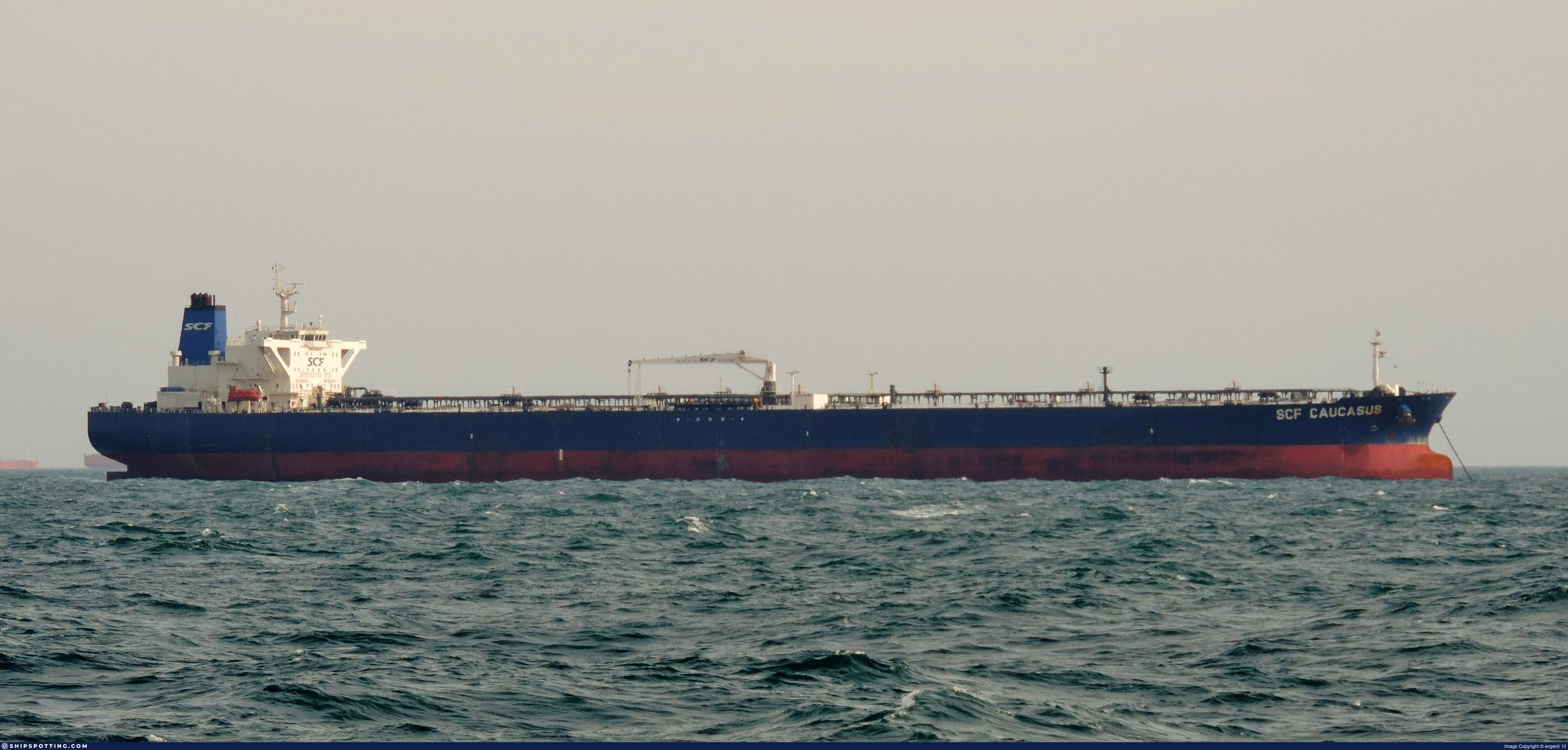
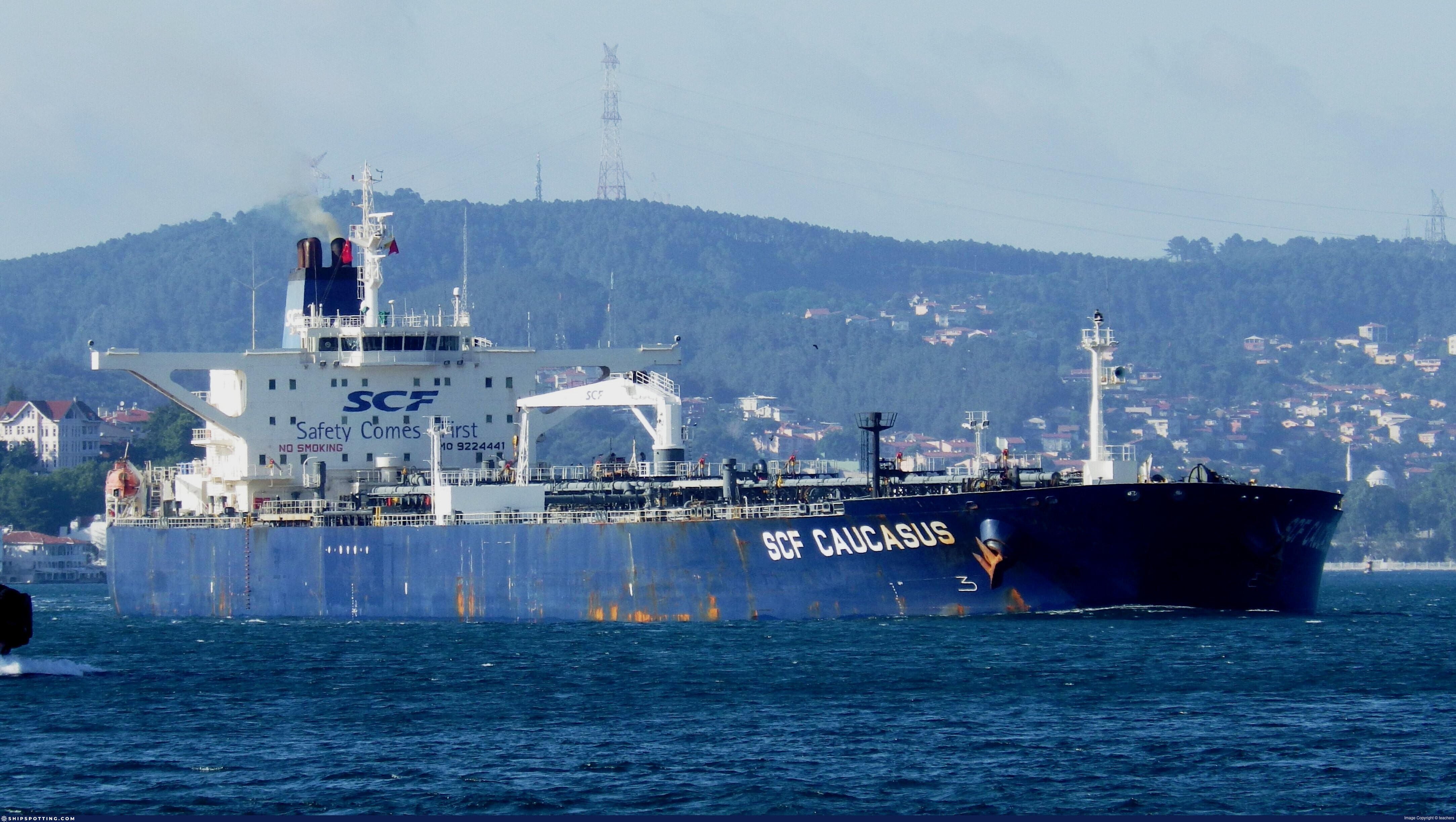
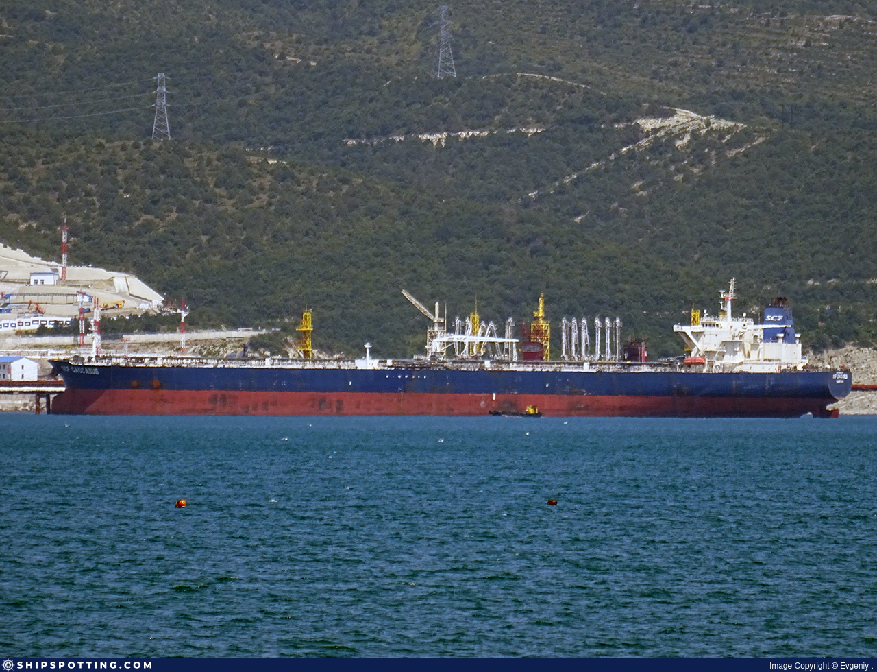
IMO 9224441
Vessel information
Vessel Name
GRUS I View name history 📜
IMO Number
9224441
MMSI
352003221
Vessel Type
Oil Tanker | Navire-citerne pour produits pétroliers
Flag
🇨🇲 Cameroon View flag history 📜
Call Sign
3E6082
Gross Tonnage
81,085 GT
Year Built
2002
Sanctioned by
Company & Ownership
Trident Beauty Ltd
IMO Company: 6443597
Address
C/O: Vigor Marine Services LLP Shop 113, Plot 9, Bhoomi Mall, Sector 15, CBD Belapur, Mumbai, 400614, India.
Status
Active
Fleet
1.0 owner, 0.0 operator, 0.0 manager, 0.0 beneficial
Management & Operations
ISM Manager
SEAPON SHIP MANAGEMENT LLP
Office 65, B Wing, Aggarwal Trade Center, Sector 11, CBD Belapur, Navi Mumbai, Maharashtra, 400614, India.
Commercial Manager
VIGOR MARINE SERVICES LLP
Shop 113, Plot 9, Bhoomi Mall, Sector 15, CBD Belapur, Mumbai, 400614, India.
Registered Owner
TRIDENT BEAUTY LTD
C/O: Vigor Marine Services LLP Shop 113, Plot 9, Bhoomi Mall, Sector 15, CBD Belapur, Mumbai, 400614, India.
Classification & Safety
Current Classification
Russian Maritime Register of Shipping
Delivered
Port State Control (PSC) Inspections
Risk Level
LOW
Last 36 Months
6
Inspections
Last Inspection
📍 Singapore
📅 2026-05-21
Survey Renewal & Certificates
| Code | Type | Issuer | Issued | Expires |
|---|---|---|---|---|
| 509 | Document of Compliance | Lloyd`s Register (160) | 04/08/2023 | 03/08/2028 |
| 507 | International Sewage Pollution Prevention | Lloyd`s Register (160) | 03/11/2022 | 31/03/2027 |
Programs & Notes
EU Russia Sanctions – Shadow Fleet | SEMA (Canada) — vessel designations | Russia Sanctions Act 2022 (NZ) | The Russia (Sanctions) (EU Exit) Regulations 2019
Vessel Changes


AIS Events
50 events detected • 8 zones • Last: Jun 16, 2026
Zone Dwell
Brittany Coast Surveillance Zone
Jun 16, 2026 01:01 UTC
80.0%
- Zone: Brittany Coast Surveillance Zone
- Duration: 1h 5m
- Data Points: 25 AIS positions
- Period: 2026-06-16T01:01:29+00:00 to 2026-06-16T02:06:49+00:00
Show Raw Evidence JSON
{
    "zone_id": "discovered_050",
    "zone_name": "Brittany Coast Surveillance Zone",
    "dwell_minutes": 65.2999999999999971578290569595992565155029296875,
    "points_in_zone": 25,
    "first_point": {
        "ts": "2026-06-16T01:01:29+00:00",
        "lat": 35.03687670000000053960320656187832355499267578125,
        "lon": 129.5034699999999929787009023129940032958984375
    },
    "last_point": {
        "ts": "2026-06-16T02:06:49+00:00",
        "lat": 34.8629983000000009951691026799380779266357421875,
        "lon": 129.360956700000002683736965991556644439697265625
    }
}
Zone Dwell
Brittany Coast Surveillance Zone
Jun 16, 2026 00:40 UTC
80.0%
- Zone: Brittany Coast Surveillance Zone
- Duration: 1h 26m
- Data Points: 32 AIS positions
- Period: 2026-06-16T00:40:49+00:00 to 2026-06-16T02:06:49+00:00
Show Raw Evidence JSON
{
    "zone_id": "discovered_050",
    "zone_name": "Brittany Coast Surveillance Zone",
    "dwell_minutes": 86,
    "points_in_zone": 32,
    "first_point": {
        "ts": "2026-06-16T00:40:49+00:00",
        "lat": 35.0942433000000022502717911265790462493896484375,
        "lon": 129.548914999999993824530974961817264556884765625
    },
    "last_point": {
        "ts": "2026-06-16T02:06:49+00:00",
        "lat": 34.8629983000000009951691026799380779266357421875,
        "lon": 129.360956700000002683736965991556644439697265625
    }
}
Zone Dwell
Brittany Coast Surveillance Zone
Jun 6, 2026 17:01 UTC
80.0%
- Zone: Brittany Coast Surveillance Zone
- Duration: 1h 54m
- Data Points: 57 AIS positions
- Period: 2026-06-06T17:01:28+00:00 to 2026-06-06T18:56:12+00:00
Show Raw Evidence JSON
{
    "zone_id": "discovered_050",
    "zone_name": "Brittany Coast Surveillance Zone",
    "dwell_minutes": 114.7000000000000028421709430404007434844970703125,
    "points_in_zone": 57,
    "first_point": {
        "ts": "2026-06-06T17:01:28+00:00",
        "lat": 34.96416500000000127101884572766721248626708984375,
        "lon": 129.453966699999995171310729347169399261474609375
    },
    "last_point": {
        "ts": "2026-06-06T18:56:12+00:00",
        "lat": 35.30025830000000297559381579048931598663330078125,
        "lon": 129.7251982999999881940311752259731292724609375
    }
}
Zone Dwell
Brittany Coast Surveillance Zone
Jun 6, 2026 16:31 UTC
80.0%
- Zone: Brittany Coast Surveillance Zone
- Duration: 2h 25m
- Data Points: 70 AIS positions
- Period: 2026-06-06T16:31:08+00:00 to 2026-06-06T18:56:12+00:00
Show Raw Evidence JSON
{
    "zone_id": "discovered_050",
    "zone_name": "Brittany Coast Surveillance Zone",
    "dwell_minutes": 145.099999999999994315658113919198513031005859375,
    "points_in_zone": 70,
    "first_point": {
        "ts": "2026-06-06T16:31:08+00:00",
        "lat": 34.8899483000000003585228114388883113861083984375,
        "lon": 129.36241499999999859937815926969051361083984375
    },
    "last_point": {
        "ts": "2026-06-06T18:56:12+00:00",
        "lat": 35.30025830000000297559381579048931598663330078125,
        "lon": 129.7251982999999881940311752259731292724609375
    }
}
Zone Dwell
Central Mediterranean Sanctions Monitoring Zone
Apr 26, 2026 01:47 UTC
80.0%
- Zone: Central Mediterranean Sanctions Monitoring Zone
- Duration: 1h 2m
- Data Points: 7 AIS positions
- Period: 2026-04-26T01:47:31+00:00 to 2026-04-26T02:50:04+00:00
Show Raw Evidence JSON
{
    "zone_id": "discovered_016",
    "zone_name": "Eastern Mediterranean Monitoring Zone",
    "dwell_minutes": 62.5,
    "points_in_zone": 7,
    "first_point": {
        "ts": "2026-04-26T01:47:31+00:00",
        "lat": 31.460384999999998711928128614090383052825927734375,
        "lon": 32.3086382999999983667294145561754703521728515625
    },
    "last_point": {
        "ts": "2026-04-26T02:50:04+00:00",
        "lat": 31.451481699999998653538568760268390178680419921875,
        "lon": 32.4091566999999969311829772777855396270751953125
    }
}
Loiter
Central Mediterranean Sanctions Monitoring Zone
Apr 25, 2026 23:07 UTC
75.0%
- Duration: 2h 47m
- Radius: 1,047 meters
- Data Points: 13 AIS positions
- Centroid: 31.4612, 32.3060
- Zone: Central Mediterranean Sanctions Monitoring Zone
Show Raw Evidence JSON
{
    "radius_m": 1047.200000000000045474735088646411895751953125,
    "duration_minutes": 167.19999999999998863131622783839702606201171875,
    "points": 13,
    "centroid": {
        "lat": 31.46122706153845882681707735173404216766357421875,
        "lon": 32.30601693076922487080082646571099758148193359375
    },
    "bbox": {
        "min_lat": 31.460384999999998711928128614090383052825927734375,
        "min_lon": 32.30473169999999782930899527855217456817626953125,
        "max_lat": 31.46133999999999986130205797962844371795654296875,
        "max_lon": 32.31703499999999706915332353673875331878662109375
    },
    "zone_id": "discovered_016"
}
Zone Dwell
Central Mediterranean Sanctions Monitoring Zone
Apr 25, 2026 23:07 UTC
80.0%
- Zone: Central Mediterranean Sanctions Monitoring Zone
- Duration: 3h 42m
- Data Points: 18 AIS positions
- Period: 2026-04-25T23:07:41+00:00 to 2026-04-26T02:50:04+00:00
Show Raw Evidence JSON
{
    "zone_id": "discovered_016",
    "zone_name": "Eastern Mediterranean Monitoring Zone",
    "dwell_minutes": 222.400000000000005684341886080801486968994140625,
    "points_in_zone": 18,
    "first_point": {
        "ts": "2026-04-25T23:07:41+00:00",
        "lat": 31.46133999999999986130205797962844371795654296875,
        "lon": 32.30477499999999935198502498678863048553466796875
    },
    "last_point": {
        "ts": "2026-04-26T02:50:04+00:00",
        "lat": 31.451481699999998653538568760268390178680419921875,
        "lon": 32.4091566999999969311829772777855396270751953125
    }
}
Loiter
Central Mediterranean Sanctions Monitoring Zone
Apr 25, 2026 22:01 UTC
75.0%
- Duration: 3h 53m
- Radius: 1,094 meters
- Data Points: 21 AIS positions
- Centroid: 31.4613, 32.3055
- Zone: Central Mediterranean Sanctions Monitoring Zone
Show Raw Evidence JSON
{
    "radius_m": 1093.700000000000045474735088646411895751953125,
    "duration_minutes": 233.19999999999998863131622783839702606201171875,
    "points": 21,
    "centroid": {
        "lat": 31.46126112857142942402788321487605571746826171875,
        "lon": 32.3055277857142897346420795656740665435791015625
    },
    "bbox": {
        "min_lat": 31.460384999999998711928128614090383052825927734375,
        "min_lon": 32.30468330000000065638232626952230930328369140625,
        "max_lat": 31.46133999999999986130205797962844371795654296875,
        "max_lon": 32.31703499999999706915332353673875331878662109375
    },
    "zone_id": "discovered_016"
}
Zone Dwell
Central Mediterranean Sanctions Monitoring Zone
Apr 25, 2026 22:01 UTC
80.0%
- Zone: Central Mediterranean Sanctions Monitoring Zone
- Duration: 4h 48m
- Data Points: 26 AIS positions
- Period: 2026-04-25T22:01:40+00:00 to 2026-04-26T02:50:04+00:00
Show Raw Evidence JSON
{
    "zone_id": "discovered_016",
    "zone_name": "Eastern Mediterranean Monitoring Zone",
    "dwell_minutes": 288.3999999999999772626324556767940521240234375,
    "points_in_zone": 26,
    "first_point": {
        "ts": "2026-04-25T22:01:40+00:00",
        "lat": 31.4612750000000005456968210637569427490234375,
        "lon": 32.30468330000000065638232626952230930328369140625
    },
    "last_point": {
        "ts": "2026-04-26T02:50:04+00:00",
        "lat": 31.451481699999998653538568760268390178680419921875,
        "lon": 32.4091566999999969311829772777855396270751953125
    }
}
Loiter
Central Mediterranean Sanctions Monitoring Zone
Apr 25, 2026 21:01 UTC
75.0%
- Duration: 4h 53m
- Radius: 1,119 meters
- Data Points: 31 AIS positions
- Centroid: 31.4613, 32.3053
- Zone: Central Mediterranean Sanctions Monitoring Zone
Show Raw Evidence JSON
{
    "radius_m": 1119.299999999999954525264911353588104248046875,
    "duration_minutes": 293.19999999999998863131622783839702606201171875,
    "points": 31,
    "centroid": {
        "lat": 31.46126259032258332126730238087475299835205078125,
        "lon": 32.3052577483870919650144060142338275909423828125
    },
    "bbox": {
        "min_lat": 31.460384999999998711928128614090383052825927734375,
        "min_lon": 32.3046666999999985137037583626806735992431640625,
        "max_lat": 31.46133999999999986130205797962844371795654296875,
        "max_lon": 32.31703499999999706915332353673875331878662109375
    },
    "zone_id": "discovered_016"
}
Zone Dwell
Central Mediterranean Sanctions Monitoring Zone
Apr 25, 2026 21:01 UTC
80.0%
- Zone: Central Mediterranean Sanctions Monitoring Zone
- Duration: 5h 48m
- Data Points: 36 AIS positions
- Period: 2026-04-25T21:01:40+00:00 to 2026-04-26T02:50:04+00:00
Show Raw Evidence JSON
{
    "zone_id": "discovered_016",
    "zone_name": "Eastern Mediterranean Monitoring Zone",
    "dwell_minutes": 348.3999999999999772626324556767940521240234375,
    "points_in_zone": 36,
    "first_point": {
        "ts": "2026-04-25T21:01:40+00:00",
        "lat": 31.46124999999999971578290569595992565155029296875,
        "lon": 32.304671700000000100772012956440448760986328125
    },
    "last_point": {
        "ts": "2026-04-26T02:50:04+00:00",
        "lat": 31.451481699999998653538568760268390178680419921875,
        "lon": 32.4091566999999969311829772777855396270751953125
    }
}
Loiter
Central Mediterranean Sanctions Monitoring Zone
Apr 25, 2026 20:01 UTC
75.0%
- Duration: 5h 52m
- Radius: 1,134 meters
- Data Points: 45 AIS positions
- Centroid: 31.4611, 32.3051
- Zone: Central Mediterranean Sanctions Monitoring Zone
Show Raw Evidence JSON
{
    "radius_m": 1134.200000000000045474735088646411895751953125,
    "duration_minutes": 352.8999999999999772626324556767940521240234375,
    "points": 45,
    "centroid": {
        "lat": 31.461066375555564178512213402427732944488525390625,
        "lon": 32.30510459111109611285428400151431560516357421875
    },
    "bbox": {
        "min_lat": 31.459783300000001560192686156369745731353759765625,
        "min_lon": 32.30441330000000021982486941851675510406494140625,
        "max_lat": 31.4613650000000006912159733474254608154296875,
        "max_lon": 32.31703499999999706915332353673875331878662109375
    },
    "zone_id": "discovered_016"
}
Zone Dwell
Central Mediterranean Sanctions Monitoring Zone
Apr 25, 2026 20:01 UTC
80.0%
- Zone: Central Mediterranean Sanctions Monitoring Zone
- Duration: 6h 38m
- Data Points: 46 AIS positions
- Period: 2026-04-25T20:11:45+00:00 to 2026-04-26T02:50:04+00:00
Show Raw Evidence JSON
{
    "zone_id": "discovered_016",
    "zone_name": "Eastern Mediterranean Monitoring Zone",
    "dwell_minutes": 398.30000000000001136868377216160297393798828125,
    "points_in_zone": 46,
    "first_point": {
        "ts": "2026-04-25T20:11:45+00:00",
        "lat": 31.45995500000000077989170677028596401214599609375,
        "lon": 32.30455330000000202517185243777930736541748046875
    },
    "last_point": {
        "ts": "2026-04-26T02:50:04+00:00",
        "lat": 31.451481699999998653538568760268390178680419921875,
        "lon": 32.4091566999999969311829772777855396270751953125
    }
}
Loiter
Central Mediterranean Sanctions Monitoring Zone
Apr 25, 2026 19:47 UTC
75.0%
- Duration: 5h 58m
- Radius: 1,138 meters
- Data Points: 46 AIS positions
- Centroid: 31.4610, 32.3051
- Zone: Central Mediterranean Sanctions Monitoring Zone
Show Raw Evidence JSON
{
    "radius_m": 1138.299999999999954525264911353588104248046875,
    "duration_minutes": 358.1000000000000227373675443232059478759765625,
    "points": 46,
    "centroid": {
        "lat": 31.461042904347831239419974735938012599945068359375,
        "lon": 32.30506133913042532412873697467148303985595703125
    },
    "bbox": {
        "min_lat": 31.459783300000001560192686156369745731353759765625,
        "min_lon": 32.30311499999999824694896233268082141876220703125,
        "max_lat": 31.4613650000000006912159733474254608154296875,
        "max_lon": 32.31703499999999706915332353673875331878662109375
    },
    "zone_id": "discovered_016"
}
Zone Dwell
Central Mediterranean Sanctions Monitoring Zone
Apr 25, 2026 19:03 UTC
80.0%
- Zone: Central Mediterranean Sanctions Monitoring Zone
- Duration: 6h 34m
- Data Points: 58 AIS positions
- Period: 2026-04-25T19:20:46+00:00 to 2026-04-26T01:54:52+00:00
Show Raw Evidence JSON
{
    "zone_id": "discovered_016",
    "zone_name": "Eastern Mediterranean Monitoring Zone",
    "dwell_minutes": 394.1000000000000227373675443232059478759765625,
    "points_in_zone": 58,
    "first_point": {
        "ts": "2026-04-25T19:20:46+00:00",
        "lat": 31.4816383000000001857188181020319461822509765625,
        "lon": 32.2740500000000025693225325085222721099853515625
    },
    "last_point": {
        "ts": "2026-04-26T01:54:52+00:00",
        "lat": 31.46129669999999833862602827139198780059814453125,
        "lon": 32.31703499999999706915332353673875331878662109375
    }
}
Zone Dwell
Central Mediterranean Sanctions Monitoring Zone
Apr 25, 2026 18:00 UTC
80.0%
- Zone: Central Mediterranean Sanctions Monitoring Zone
- Duration: 5h 42m
- Data Points: 92 AIS positions
- Period: 2026-04-25T18:00:58+00:00 to 2026-04-25T23:43:42+00:00
Show Raw Evidence JSON
{
    "zone_id": "discovered_016",
    "zone_name": "Eastern Mediterranean Monitoring Zone",
    "dwell_minutes": 342.69999999999998863131622783839702606201171875,
    "points_in_zone": 92,
    "first_point": {
        "ts": "2026-04-25T18:00:58+00:00",
        "lat": 31.625840000000000173940861714072525501251220703125,
        "lon": 32.09159170000000216305124922655522823333740234375
    },
    "last_point": {
        "ts": "2026-04-25T23:43:42+00:00",
        "lat": 31.461330000000000239879227592609822750091552734375,
        "lon": 32.30482669999999956189640215598046779632568359375
    }
}
Zone Dwell
Central Mediterranean Sanctions Monitoring Zone
Apr 25, 2026 17:00 UTC
80.0%
- Zone: Central Mediterranean Sanctions Monitoring Zone
- Duration: 6h 33m
- Data Points: 129 AIS positions
- Period: 2026-04-25T17:10:12+00:00 to 2026-04-25T23:43:42+00:00
Show Raw Evidence JSON
{
    "zone_id": "discovered_016",
    "zone_name": "Eastern Mediterranean Monitoring Zone",
    "dwell_minutes": 393.5,
    "points_in_zone": 129,
    "first_point": {
        "ts": "2026-04-25T17:10:12+00:00",
        "lat": 31.7382233000000013589669833891093730926513671875,
        "lon": 31.95265669999999857964212424121797084808349609375
    },
    "last_point": {
        "ts": "2026-04-25T23:43:42+00:00",
        "lat": 31.461330000000000239879227592609822750091552734375,
        "lon": 32.30482669999999956189640215598046779632568359375
    }
}
Zone Dwell
Central Mediterranean Sanctions Monitoring Zone
Apr 25, 2026 16:00 UTC
80.0%
- Zone: Central Mediterranean Sanctions Monitoring Zone
- Duration: 6h 36m
- Data Points: 140 AIS positions
- Period: 2026-04-25T16:52:13+00:00 to 2026-04-25T23:28:41+00:00
Show Raw Evidence JSON
{
    "zone_id": "discovered_016",
    "zone_name": "Eastern Mediterranean Monitoring Zone",
    "dwell_minutes": 396.5,
    "points_in_zone": 140,
    "first_point": {
        "ts": "2026-04-25T16:52:13+00:00",
        "lat": 31.769555000000000433146851719357073307037353515625,
        "lon": 31.893833300000000718910087016411125659942626953125
    },
    "last_point": {
        "ts": "2026-04-25T23:28:41+00:00",
        "lat": 31.46130000000000137561073643155395984649658203125,
        "lon": 32.304761700000000246291165240108966827392578125
    }
}
Zone Dwell
Central Mediterranean Sanctions Monitoring Zone
Apr 25, 2026 15:00 UTC
80.0%
- Zone: Central Mediterranean Sanctions Monitoring Zone
- Duration: 6h 33m
- Data Points: 159 AIS positions
- Period: 2026-04-25T15:52:24+00:00 to 2026-04-25T22:25:40+00:00
Show Raw Evidence JSON
{
    "zone_id": "discovered_016",
    "zone_name": "Eastern Mediterranean Monitoring Zone",
    "dwell_minutes": 393.30000000000001136868377216160297393798828125,
    "points_in_zone": 159,
    "first_point": {
        "ts": "2026-04-25T15:52:24+00:00",
        "lat": 31.866330000000001376747604808770120143890380859375,
        "lon": 31.69379169999999845686033950187265872955322265625
    },
    "last_point": {
        "ts": "2026-04-25T22:25:40+00:00",
        "lat": 31.461331699999998789962774026207625865936279296875,
        "lon": 32.30473669999999941637724987231194972991943359375
    }
}
Zone Dwell
Central Mediterranean Sanctions Monitoring Zone
Apr 25, 2026 14:02 UTC
80.0%
- Zone: Central Mediterranean Sanctions Monitoring Zone
- Duration: 6h 35m
- Data Points: 183 AIS positions
- Period: 2026-04-25T14:53:02+00:00 to 2026-04-25T21:28:40+00:00
Show Raw Evidence JSON
{
    "zone_id": "discovered_016",
    "zone_name": "Eastern Mediterranean Monitoring Zone",
    "dwell_minutes": 395.6000000000000227373675443232059478759765625,
    "points_in_zone": 183,
    "first_point": {
        "ts": "2026-04-25T14:53:02+00:00",
        "lat": 31.980630000000001444959707441739737987518310546875,
        "lon": 31.51632670000000047139110392890870571136474609375
    },
    "last_point": {
        "ts": "2026-04-25T21:28:40+00:00",
        "lat": 31.4612632999999988214767654426395893096923828125,
        "lon": 32.304716700000000173531589098274707794189453125
    }
}
Zone Dwell
Central Mediterranean Sanctions Monitoring Zone
Apr 25, 2026 13:02 UTC
80.0%
- Zone: Central Mediterranean Sanctions Monitoring Zone
- Duration: 6h 35m
- Data Points: 197 AIS positions
- Period: 2026-04-25T13:51:05+00:00 to 2026-04-25T20:26:17+00:00
Show Raw Evidence JSON
{
    "zone_id": "discovered_016",
    "zone_name": "Eastern Mediterranean Monitoring Zone",
    "dwell_minutes": 395.19999999999998863131622783839702606201171875,
    "points_in_zone": 197,
    "first_point": {
        "ts": "2026-04-25T13:51:05+00:00",
        "lat": 32.133143300000000408545020036399364471435546875,
        "lon": 31.37068000000000012050804798491299152374267578125
    },
    "last_point": {
        "ts": "2026-04-25T20:26:17+00:00",
        "lat": 31.4611732999999986759576131589710712432861328125,
        "lon": 32.304654999999996789483702741563320159912109375
    }
}
Zone Dwell
Central Mediterranean Sanctions Monitoring Zone
Apr 25, 2026 12:01 UTC
80.0%
- Zone: Central Mediterranean Sanctions Monitoring Zone
- Duration: 6h 38m
- Data Points: 215 AIS positions
- Period: 2026-04-25T12:50:16+00:00 to 2026-04-25T19:29:09+00:00
Show Raw Evidence JSON
{
    "zone_id": "discovered_016",
    "zone_name": "Eastern Mediterranean Monitoring Zone",
    "dwell_minutes": 398.8999999999999772626324556767940521240234375,
    "points_in_zone": 215,
    "first_point": {
        "ts": "2026-04-25T12:50:16+00:00",
        "lat": 32.28860499999999689180185669101774692535400390625,
        "lon": 31.2130532999999985577233019284904003143310546875
    },
    "last_point": {
        "ts": "2026-04-25T19:29:09+00:00",
        "lat": 31.475564999999999571400621789507567882537841796875,
        "lon": 32.2821517000000000052750692702829837799072265625
    }
}
Zone Dwell
discovered_048
Apr 25, 2026 12:01 UTC
80.0%
- Zone: discovered_048
- Duration: 1h 3m
- Data Points: 42 AIS positions
- Period: 2026-04-25T12:01:55+00:00 to 2026-04-25T13:05:15+00:00
Show Raw Evidence JSON
{
    "zone_id": "discovered_048",
    "zone_name": "Eastern Zealand Surveillance Zone",
    "dwell_minutes": 63.2999999999999971578290569595992565155029296875,
    "points_in_zone": 42,
    "first_point": {
        "ts": "2026-04-25T12:01:55+00:00",
        "lat": 32.41558330000000154313966049812734127044677734375,
        "lon": 31.092498299999999034071151982061564922332763671875
    },
    "last_point": {
        "ts": "2026-04-25T13:05:15+00:00",
        "lat": 32.25025169999999974379534251056611537933349609375,
        "lon": 31.25135829999999970141288940794765949249267578125
    }
}
Zone Dwell
Central Mediterranean Sanctions Monitoring Zone
Apr 25, 2026 11:43 UTC
80.0%
- Zone: Central Mediterranean Sanctions Monitoring Zone
- Duration: 6h 39m
- Data Points: 229 AIS positions
- Period: 2026-04-25T11:50:55+00:00 to 2026-04-25T18:30:04+00:00
Show Raw Evidence JSON
{
    "zone_id": "discovered_016",
    "zone_name": "Eastern Mediterranean Monitoring Zone",
    "dwell_minutes": 399.1000000000000227373675443232059478759765625,
    "points_in_zone": 229,
    "first_point": {
        "ts": "2026-04-25T11:50:55+00:00",
        "lat": 32.44733500000000248064679908566176891326904296875,
        "lon": 31.0625782999999984212990966625511646270751953125
    },
    "last_point": {
        "ts": "2026-04-25T18:30:04+00:00",
        "lat": 31.56094999999999828332875040359795093536376953125,
        "lon": 32.16897999999999768760972074232995510101318359375
    }
}
Zone Dwell
discovered_048
Apr 25, 2026 11:01 UTC
80.0%
- Zone: discovered_048
- Duration: 2h 4m
- Data Points: 78 AIS positions
- Period: 2026-04-25T11:01:15+00:00 to 2026-04-25T13:05:15+00:00
Show Raw Evidence JSON
{
    "zone_id": "discovered_048",
    "zone_name": "Eastern Zealand Surveillance Zone",
    "dwell_minutes": 124,
    "points_in_zone": 78,
    "first_point": {
        "ts": "2026-04-25T11:01:15+00:00",
        "lat": 32.5895282999999977846528054215013980865478515625,
        "lon": 30.936551699999998987777871661819517612457275390625
    },
    "last_point": {
        "ts": "2026-04-25T13:05:15+00:00",
        "lat": 32.25025169999999974379534251056611537933349609375,
        "lon": 31.25135829999999970141288940794765949249267578125
    }
}
Zone Dwell
discovered_048
Apr 25, 2026 10:36 UTC
80.0%
- Zone: discovered_048
- Duration: 2h 28m
- Data Points: 89 AIS positions
- Period: 2026-04-25T10:36:34+00:00 to 2026-04-25T13:05:15+00:00
Show Raw Evidence JSON
{
    "zone_id": "discovered_048",
    "zone_name": "Eastern Zealand Surveillance Zone",
    "dwell_minutes": 148.69999999999998863131622783839702606201171875,
    "points_in_zone": 89,
    "first_point": {
        "ts": "2026-04-25T10:36:34+00:00",
        "lat": 32.65494000000000340833139489404857158660888671875,
        "lon": 30.87019169999999945730451145209372043609619140625
    },
    "last_point": {
        "ts": "2026-04-25T13:05:15+00:00",
        "lat": 32.25025169999999974379534251056611537933349609375,
        "lon": 31.25135829999999970141288940794765949249267578125
    }
}
Zone Dwell
Eastern Mediterranean Surveillance Zone
Apr 25, 2026 10:05 UTC
80.0%
- Zone: Eastern Mediterranean Surveillance Zone
- Duration: 1h 54m
- Data Points: 57 AIS positions
- Period: 2026-04-25T10:05:15+00:00 to 2026-04-25T11:59:45+00:00
Show Raw Evidence JSON
{
    "zone_id": "discovered_207",
    "zone_name": "Eastern Mediterranean Surveillance Zone",
    "dwell_minutes": 114.5,
    "points_in_zone": 57,
    "first_point": {
        "ts": "2026-04-25T10:05:15+00:00",
        "lat": 32.73461999999999960664354148320853710174560546875,
        "lon": 30.7812483000000014499164535664021968841552734375
    },
    "last_point": {
        "ts": "2026-04-25T11:59:45+00:00",
        "lat": 32.42186000000000234422259381972253322601318359375,
        "lon": 31.08661169999999884794306126423180103302001953125
    }
}
Zone Dwell
Eastern Mediterranean Surveillance Zone
Apr 25, 2026 09:30 UTC
80.0%
- Zone: Eastern Mediterranean Surveillance Zone
- Duration: 2h 29m
- Data Points: 64 AIS positions
- Period: 2026-04-25T09:30:45+00:00 to 2026-04-25T11:59:45+00:00
Show Raw Evidence JSON
{
    "zone_id": "discovered_207",
    "zone_name": "Eastern Mediterranean Surveillance Zone",
    "dwell_minutes": 149,
    "points_in_zone": 64,
    "first_point": {
        "ts": "2026-04-25T09:30:45+00:00",
        "lat": 32.82281329999999996971382643096148967742919921875,
        "lon": 30.684805000000000774207364884205162525177001953125
    },
    "last_point": {
        "ts": "2026-04-25T11:59:45+00:00",
        "lat": 32.42186000000000234422259381972253322601318359375,
        "lon": 31.08661169999999884794306126423180103302001953125
    }
}
Zone Dwell
North Sea Surveillance Zone
Apr 25, 2026 08:12 UTC
80.0%
- Zone: North Sea Surveillance Zone
- Duration: 1h 40m
- Data Points: 20 AIS positions
- Period: 2026-04-25T08:12:54+00:00 to 2026-04-25T09:53:36+00:00
Show Raw Evidence JSON
{
    "zone_id": "discovered_128",
    "zone_name": "Eastern Mediterranean Surveillance Zone",
    "dwell_minutes": 100.7000000000000028421709430404007434844970703125,
    "points_in_zone": 20,
    "first_point": {
        "ts": "2026-04-25T08:12:54+00:00",
        "lat": 33.02215170000000199479472939856350421905517578125,
        "lon": 30.479866699999998758130459464155137538909912109375
    },
    "last_point": {
        "ts": "2026-04-25T09:53:36+00:00",
        "lat": 32.7644149999999996225596987642347812652587890625,
        "lon": 30.748021699999998901375874993391335010528564453125
    }
}
Ais Gap🛰️✗
Southeast Aegean Monitoring Zone
Apr 24, 2026 09:39 UTC
70.0%
- Gap Duration: 4 hours
- Last Seen: 2026-04-24T09:39:04+00:00 at 36.4757, 26.7779 (Zone: Southeast Aegean Monitoring Zone)
- Next Seen: 2026-04-24T13:39:14+00:00 at 35.9414, 27.5165
🛰️ Gap Corroboration
No Imagery
These are snapshots that may corroborate presence during the gap. They do not reconstruct a continuous route.
SAR Imagery (Sentinel-1)
Status: ✗ No SAR coverage
No Sentinel-1 scenes covering corridor and time window
VIIRS Thermal Anomaly
Status: ✗ No detections
No VIIRS thermal/light detections in corridor
Show Raw Evidence JSON
{
    "gap_minutes": 240.19999999999998863131622783839702606201171875,
    "last_seen": {
        "ts": "2026-04-24T09:39:04+00:00",
        "lat": 36.475736699999998791099642403423786163330078125,
        "lon": 26.777930000000001342641553492285311222076416015625,
        "sog": 11.5999999999999996447286321199499070644378662109375,
        "zone_id": "discovered_083"
    },
    "next_seen": {
        "ts": "2026-04-24T13:39:14+00:00",
        "lat": 35.941360000000003083187039010226726531982421875,
        "lon": 27.516504999999998659632183262147009372711181640625,
        "zone_ids": [
            "discovered_067"
        ]
    },
    "gap_enrichment": {
        "status": "not_found",
        "corridor": {
            "start": {
                "lat": 36.475736699999998791099642403423786163330078125,
                "lon": 26.777930000000001342641553492285311222076416015625,
                "ts": "2026-04-24T09:39:04+00:00"
            },
            "end": {
                "lat": 35.941360000000003083187039010226726531982421875,
                "lon": 27.516504999999998659632183262147009372711181640625,
                "ts": "2026-04-24T13:39:14+00:00"
            },
            "bbox": {
                "min_lat": 35.76118000000000307636582874692976474761962890625,
                "min_lon": 26.55462299999999942201611702330410480499267578125,
                "max_lat": 36.6559170000000023037500795908272266387939453125,
                "max_lon": 27.739812000000000580257619731128215789794921875
            },
            "buffer_km": 20
        },
        "sar": {
            "status": "not_found",
            "notes": "No Sentinel-1 scenes covering corridor and time window"
        },
        "viirs": {
            "status": "not_found",
            "notes": "No VIIRS thermal\/light detections in corridor"
        },
        "searched_at": "2026-04-24T13:45:12.285755+00:00"
    }
}
Zone Dwell
Bosphorus/Dardanelles Approach
Apr 21, 2026 14:00 UTC
80.0%
- Zone: Bosphorus/Dardanelles Approach
- Duration: 1h 18m
- Data Points: 33 AIS positions
- Period: 2026-04-21T14:00:25+00:00 to 2026-04-21T15:19:05+00:00
Show Raw Evidence JSON
{
    "zone_id": "osint_bosphorus",
    "zone_name": "Bosphorus\/Dardanelles Approach",
    "dwell_minutes": 78.7000000000000028421709430404007434844970703125,
    "points_in_zone": 33,
    "first_point": {
        "ts": "2026-04-21T14:00:25+00:00",
        "lat": 40.9450700000000011868905858136713504791259765625,
        "lon": 28.914363300000001544276528875343501567840576171875
    },
    "last_point": {
        "ts": "2026-04-21T15:19:05+00:00",
        "lat": 40.91817329999999941492205834947526454925537109375,
        "lon": 28.847878300000001416947270627133548259735107421875
    }
}
Zone Dwell
Bosphorus/Dardanelles Approach
Apr 21, 2026 13:13 UTC
80.0%
- Zone: Bosphorus/Dardanelles Approach
- Duration: 2h 6m
- Data Points: 46 AIS positions
- Period: 2026-04-21T13:13:06+00:00 to 2026-04-21T15:19:05+00:00
Show Raw Evidence JSON
{
    "zone_id": "osint_bosphorus",
    "zone_name": "Bosphorus\/Dardanelles Approach",
    "dwell_minutes": 126,
    "points_in_zone": 46,
    "first_point": {
        "ts": "2026-04-21T13:13:06+00:00",
        "lat": 40.969954999999998790372046642005443572998046875,
        "lon": 28.97576169999999962101355777122080326080322265625
    },
    "last_point": {
        "ts": "2026-04-21T15:19:05+00:00",
        "lat": 40.91817329999999941492205834947526454925537109375,
        "lon": 28.847878300000001416947270627133548259735107421875
    }
}
Zone Dwell
Bosphorus/Dardanelles Approach
Apr 20, 2026 12:08 UTC
80.0%
- Zone: Bosphorus/Dardanelles Approach
- Duration: 1 hours
- Data Points: 6 AIS positions
- Period: 2026-04-20T12:08:51+00:00 to 2026-04-20T13:08:51+00:00
Show Raw Evidence JSON
{
    "zone_id": "osint_bosphorus",
    "zone_name": "Bosphorus\/Dardanelles Approach",
    "dwell_minutes": 60,
    "points_in_zone": 6,
    "first_point": {
        "ts": "2026-04-20T12:08:51+00:00",
        "lat": 41.38372170000000238587745116092264652252197265625,
        "lon": 28.910503299999998461089489865116775035858154296875
    },
    "last_point": {
        "ts": "2026-04-20T13:08:51+00:00",
        "lat": 41.38327000000000310819814330898225307464599609375,
        "lon": 28.90627500000000082991391536779701709747314453125
    }
}
Zone Dwell
discovered_020
Apr 20, 2026 12:08 UTC
80.0%
- Zone: discovered_020
- Duration: 1 hours
- Data Points: 6 AIS positions
- Period: 2026-04-20T12:08:51+00:00 to 2026-04-20T13:08:51+00:00
Show Raw Evidence JSON
{
    "zone_id": "discovered_020",
    "zone_name": "Black Sea Sanctioned Vessel Monitoring Zone",
    "dwell_minutes": 60,
    "points_in_zone": 6,
    "first_point": {
        "ts": "2026-04-20T12:08:51+00:00",
        "lat": 41.38372170000000238587745116092264652252197265625,
        "lon": 28.910503299999998461089489865116775035858154296875
    },
    "last_point": {
        "ts": "2026-04-20T13:08:51+00:00",
        "lat": 41.38327000000000310819814330898225307464599609375,
        "lon": 28.90627500000000082991391536779701709747314453125
    }
}
Zone Dwell
discovered_020
Apr 20, 2026 11:51 UTC
80.0%
- Zone: discovered_020
- Duration: 1h 17m
- Data Points: 9 AIS positions
- Period: 2026-04-20T11:51:10+00:00 to 2026-04-20T13:08:51+00:00
Show Raw Evidence JSON
{
    "zone_id": "discovered_020",
    "zone_name": "Black Sea Sanctioned Vessel Monitoring Zone",
    "dwell_minutes": 77.7000000000000028421709430404007434844970703125,
    "points_in_zone": 9,
    "first_point": {
        "ts": "2026-04-20T11:51:10+00:00",
        "lat": 41.38394329999999854408088140189647674560546875,
        "lon": 28.911138300000001066791810444556176662445068359375
    },
    "last_point": {
        "ts": "2026-04-20T13:08:51+00:00",
        "lat": 41.38327000000000310819814330898225307464599609375,
        "lon": 28.90627500000000082991391536779701709747314453125
    }
}
Zone Dwell
Bosphorus/Dardanelles Approach
Apr 20, 2026 11:51 UTC
80.0%
- Zone: Bosphorus/Dardanelles Approach
- Duration: 1h 17m
- Data Points: 9 AIS positions
- Period: 2026-04-20T11:51:10+00:00 to 2026-04-20T13:08:51+00:00
Show Raw Evidence JSON
{
    "zone_id": "osint_bosphorus",
    "zone_name": "Bosphorus\/Dardanelles Approach",
    "dwell_minutes": 77.7000000000000028421709430404007434844970703125,
    "points_in_zone": 9,
    "first_point": {
        "ts": "2026-04-20T11:51:10+00:00",
        "lat": 41.38394329999999854408088140189647674560546875,
        "lon": 28.911138300000001066791810444556176662445068359375
    },
    "last_point": {
        "ts": "2026-04-20T13:08:51+00:00",
        "lat": 41.38327000000000310819814330898225307464599609375,
        "lon": 28.90627500000000082991391536779701709747314453125
    }
}
Loiter
discovered_020
Apr 20, 2026 10:24 UTC
75.0%
- Duration: 2h 44m
- Radius: 428 meters
- Data Points: 13 AIS positions
- Centroid: 41.3845, 28.9111
- Zone: discovered_020
Show Raw Evidence JSON
{
    "radius_m": 428.1000000000000227373675443232059478759765625,
    "duration_minutes": 164.80000000000001136868377216160297393798828125,
    "points": 13,
    "centroid": {
        "lat": 41.3844578230769144511214108206331729888916015625,
        "lon": 28.91114359230768826591884135268628597259521484375
    },
    "bbox": {
        "min_lat": 41.38327000000000310819814330898225307464599609375,
        "min_lon": 28.90627500000000082991391536779701709747314453125,
        "max_lat": 41.38653500000000207137418328784406185150146484375,
        "max_lon": 28.9140967000000017605998436920344829559326171875
    },
    "zone_id": "discovered_020"
}
Loiter
Bosphorus/Dardanelles Approach
Apr 20, 2026 10:24 UTC
75.0%
- Duration: 2h 44m
- Radius: 428 meters
- Data Points: 13 AIS positions
- Centroid: 41.3845, 28.9111
- Zone: Bosphorus/Dardanelles Approach
Show Raw Evidence JSON
{
    "radius_m": 428.1000000000000227373675443232059478759765625,
    "duration_minutes": 164.80000000000001136868377216160297393798828125,
    "points": 13,
    "centroid": {
        "lat": 41.3844578230769144511214108206331729888916015625,
        "lon": 28.91114359230768826591884135268628597259521484375
    },
    "bbox": {
        "min_lat": 41.38327000000000310819814330898225307464599609375,
        "min_lon": 28.90627500000000082991391536779701709747314453125,
        "max_lat": 41.38653500000000207137418328784406185150146484375,
        "max_lon": 28.9140967000000017605998436920344829559326171875
    },
    "zone_id": "osint_bosphorus"
}
Zone Dwell
discovered_020
Apr 20, 2026 10:24 UTC
80.0%
- Zone: discovered_020
- Duration: 2h 44m
- Data Points: 13 AIS positions
- Period: 2026-04-20T10:24:02+00:00 to 2026-04-20T13:08:51+00:00
Show Raw Evidence JSON
{
    "zone_id": "discovered_020",
    "zone_name": "Black Sea Sanctioned Vessel Monitoring Zone",
    "dwell_minutes": 164.80000000000001136868377216160297393798828125,
    "points_in_zone": 13,
    "first_point": {
        "ts": "2026-04-20T10:24:02+00:00",
        "lat": 41.38653500000000207137418328784406185150146484375,
        "lon": 28.9140967000000017605998436920344829559326171875
    },
    "last_point": {
        "ts": "2026-04-20T13:08:51+00:00",
        "lat": 41.38327000000000310819814330898225307464599609375,
        "lon": 28.90627500000000082991391536779701709747314453125
    }
}
Zone Dwell
Bosphorus/Dardanelles Approach
Apr 20, 2026 10:24 UTC
80.0%
- Zone: Bosphorus/Dardanelles Approach
- Duration: 2h 44m
- Data Points: 13 AIS positions
- Period: 2026-04-20T10:24:02+00:00 to 2026-04-20T13:08:51+00:00
Show Raw Evidence JSON
{
    "zone_id": "osint_bosphorus",
    "zone_name": "Bosphorus\/Dardanelles Approach",
    "dwell_minutes": 164.80000000000001136868377216160297393798828125,
    "points_in_zone": 13,
    "first_point": {
        "ts": "2026-04-20T10:24:02+00:00",
        "lat": 41.38653500000000207137418328784406185150146484375,
        "lon": 28.9140967000000017605998436920344829559326171875
    },
    "last_point": {
        "ts": "2026-04-20T13:08:51+00:00",
        "lat": 41.38327000000000310819814330898225307464599609375,
        "lon": 28.90627500000000082991391536779701709747314453125
    }
}
Loiter
discovered_020
Apr 20, 2026 09:19 UTC
75.0%
- Duration: 3h 49m
- Radius: 589 meters
- Data Points: 22 AIS positions
- Centroid: 41.3857, 28.9125
- Zone: discovered_020
Show Raw Evidence JSON
{
    "radius_m": 589.3999999999999772626324556767940521240234375,
    "duration_minutes": 229.5,
    "points": 22,
    "centroid": {
        "lat": 41.38570099545455605039023794233798980712890625,
        "lon": 28.912539090909096017867341288365423679351806640625
    },
    "bbox": {
        "min_lat": 41.38327000000000310819814330898225307464599609375,
        "min_lon": 28.90627500000000082991391536779701709747314453125,
        "max_lat": 41.3876417000000031976014724932610988616943359375,
        "max_lon": 28.914718300000000539284883416257798671722412109375
    },
    "zone_id": "discovered_020"
}
Loiter
Bosphorus/Dardanelles Approach
Apr 20, 2026 09:19 UTC
75.0%
- Duration: 3h 49m
- Radius: 589 meters
- Data Points: 22 AIS positions
- Centroid: 41.3857, 28.9125
- Zone: Bosphorus/Dardanelles Approach
Show Raw Evidence JSON
{
    "radius_m": 589.3999999999999772626324556767940521240234375,
    "duration_minutes": 229.5,
    "points": 22,
    "centroid": {
        "lat": 41.38570099545455605039023794233798980712890625,
        "lon": 28.912539090909096017867341288365423679351806640625
    },
    "bbox": {
        "min_lat": 41.38327000000000310819814330898225307464599609375,
        "min_lon": 28.90627500000000082991391536779701709747314453125,
        "max_lat": 41.3876417000000031976014724932610988616943359375,
        "max_lon": 28.914718300000000539284883416257798671722412109375
    },
    "zone_id": "osint_bosphorus"
}
Zone Dwell
Bosphorus/Dardanelles Approach
Apr 20, 2026 09:19 UTC
80.0%
- Zone: Bosphorus/Dardanelles Approach
- Duration: 3h 49m
- Data Points: 22 AIS positions
- Period: 2026-04-20T09:19:21+00:00 to 2026-04-20T13:08:51+00:00
Show Raw Evidence JSON
{
    "zone_id": "osint_bosphorus",
    "zone_name": "Bosphorus\/Dardanelles Approach",
    "dwell_minutes": 229.5,
    "points_in_zone": 22,
    "first_point": {
        "ts": "2026-04-20T09:19:21+00:00",
        "lat": 41.3876417000000031976014724932610988616943359375,
        "lon": 28.914718300000000539284883416257798671722412109375
    },
    "last_point": {
        "ts": "2026-04-20T13:08:51+00:00",
        "lat": 41.38327000000000310819814330898225307464599609375,
        "lon": 28.90627500000000082991391536779701709747314453125
    }
}
Zone Dwell
discovered_020
Apr 20, 2026 09:19 UTC
80.0%
- Zone: discovered_020
- Duration: 3h 49m
- Data Points: 22 AIS positions
- Period: 2026-04-20T09:19:21+00:00 to 2026-04-20T13:08:51+00:00
Show Raw Evidence JSON
{
    "zone_id": "discovered_020",
    "zone_name": "Black Sea Sanctioned Vessel Monitoring Zone",
    "dwell_minutes": 229.5,
    "points_in_zone": 22,
    "first_point": {
        "ts": "2026-04-20T09:19:21+00:00",
        "lat": 41.3876417000000031976014724932610988616943359375,
        "lon": 28.914718300000000539284883416257798671722412109375
    },
    "last_point": {
        "ts": "2026-04-20T13:08:51+00:00",
        "lat": 41.38327000000000310819814330898225307464599609375,
        "lon": 28.90627500000000082991391536779701709747314453125
    }
}
Loiter
discovered_020
Apr 20, 2026 08:02 UTC
75.0%
- Duration: 5h 6m
- Radius: 688 meters
- Data Points: 36 AIS positions
- Centroid: 41.3863, 28.9134
- Zone: discovered_020
Show Raw Evidence JSON
{
    "radius_m": 688,
    "duration_minutes": 306.5,
    "points": 36,
    "centroid": {
        "lat": 41.386311955555555641694809310138225555419921875,
        "lon": 28.91343995277777167984822881408035755157470703125
    },
    "bbox": {
        "min_lat": 41.38327000000000310819814330898225307464599609375,
        "min_lon": 28.90627500000000082991391536779701709747314453125,
        "max_lat": 41.3876417000000031976014724932610988616943359375,
        "max_lon": 28.915036700000001701482688076794147491455078125
    },
    "zone_id": "discovered_020"
}
Loiter
Bosphorus/Dardanelles Approach
Apr 20, 2026 08:02 UTC
75.0%
- Duration: 5h 6m
- Radius: 688 meters
- Data Points: 36 AIS positions
- Centroid: 41.3863, 28.9134
- Zone: Bosphorus/Dardanelles Approach
Show Raw Evidence JSON
{
    "radius_m": 688,
    "duration_minutes": 306.5,
    "points": 36,
    "centroid": {
        "lat": 41.386311955555555641694809310138225555419921875,
        "lon": 28.91343995277777167984822881408035755157470703125
    },
    "bbox": {
        "min_lat": 41.38327000000000310819814330898225307464599609375,
        "min_lon": 28.90627500000000082991391536779701709747314453125,
        "max_lat": 41.3876417000000031976014724932610988616943359375,
        "max_lon": 28.915036700000001701482688076794147491455078125
    },
    "zone_id": "osint_bosphorus"
}
Zone Dwell
Bosphorus/Dardanelles Approach
Apr 20, 2026 08:02 UTC
80.0%
- Zone: Bosphorus/Dardanelles Approach
- Duration: 5h 6m
- Data Points: 36 AIS positions
- Period: 2026-04-20T08:02:22+00:00 to 2026-04-20T13:08:51+00:00
Show Raw Evidence JSON
{
    "zone_id": "osint_bosphorus",
    "zone_name": "Bosphorus\/Dardanelles Approach",
    "dwell_minutes": 306.5,
    "points_in_zone": 36,
    "first_point": {
        "ts": "2026-04-20T08:02:22+00:00",
        "lat": 41.38703170000000142181306728161871433258056640625,
        "lon": 28.914611699999998251087163225747644901275634765625
    },
    "last_point": {
        "ts": "2026-04-20T13:08:51+00:00",
        "lat": 41.38327000000000310819814330898225307464599609375,
        "lon": 28.90627500000000082991391536779701709747314453125
    }
}
Zone Dwell
discovered_020
Apr 20, 2026 08:02 UTC
80.0%
- Zone: discovered_020
- Duration: 5h 6m
- Data Points: 36 AIS positions
- Period: 2026-04-20T08:02:22+00:00 to 2026-04-20T13:08:51+00:00
Show Raw Evidence JSON
{
    "zone_id": "discovered_020",
    "zone_name": "Black Sea Sanctioned Vessel Monitoring Zone",
    "dwell_minutes": 306.5,
    "points_in_zone": 36,
    "first_point": {
        "ts": "2026-04-20T08:02:22+00:00",
        "lat": 41.38703170000000142181306728161871433258056640625,
        "lon": 28.914611699999998251087163225747644901275634765625
    },
    "last_point": {
        "ts": "2026-04-20T13:08:51+00:00",
        "lat": 41.38327000000000310819814330898225307464599609375,
        "lon": 28.90627500000000082991391536779701709747314453125
    }
}
Loiter
discovered_020
Apr 20, 2026 07:08 UTC
75.0%
- Duration: 6 hours
- Radius: 690 meters
- Data Points: 38 AIS positions
- Centroid: 41.3863, 28.9135
- Zone: discovered_020
Show Raw Evidence JSON
{
    "radius_m": 690.299999999999954525264911353588104248046875,
    "duration_minutes": 360.3999999999999772626324556767940521240234375,
    "points": 38,
    "centroid": {
        "lat": 41.3863259763157884663087315857410430908203125,
        "lon": 28.913461139473678684908009017817676067352294921875
    },
    "bbox": {
        "min_lat": 41.38327000000000310819814330898225307464599609375,
        "min_lon": 28.90627500000000082991391536779701709747314453125,
        "max_lat": 41.3876417000000031976014724932610988616943359375,
        "max_lon": 28.915036700000001701482688076794147491455078125
    },
    "zone_id": "discovered_020"
}
Loiter
Bosphorus/Dardanelles Approach
Apr 20, 2026 07:08 UTC
75.0%
- Duration: 6 hours
- Radius: 690 meters
- Data Points: 38 AIS positions
- Centroid: 41.3863, 28.9135
- Zone: Bosphorus/Dardanelles Approach
Show Raw Evidence JSON
{
    "radius_m": 690.299999999999954525264911353588104248046875,
    "duration_minutes": 360.3999999999999772626324556767940521240234375,
    "points": 38,
    "centroid": {
        "lat": 41.3863259763157884663087315857410430908203125,
        "lon": 28.913461139473678684908009017817676067352294921875
    },
    "bbox": {
        "min_lat": 41.38327000000000310819814330898225307464599609375,
        "min_lon": 28.90627500000000082991391536779701709747314453125,
        "max_lat": 41.3876417000000031976014724932610988616943359375,
        "max_lon": 28.915036700000001701482688076794147491455078125
    },
    "zone_id": "osint_bosphorus"
}Sanctioned on the same day
- Aditya · IMO 9323314 🇨🇦 CA🇪🇺 EU🇬🇧 UK
- Aleksey Savrasov · IMO 9645061 🇨🇦 CA🇪🇺 EU
- ALTURA · IMO 9292199 🇨🇦 CA🇪🇺 EU🇬🇧 UK
- Anabar · IMO 9194012 🇨🇦 CA
- Apate · IMO 9433016 🇨🇦 CA🇪🇺 EU🇬🇧 UK
- Armada Leader · IMO 9260483 🇨🇦 CA🇪🇺 EU
- Aura 1 · IMO 9472634 🇨🇦 CA🇪🇺 EU🇬🇧 UK
- Bergen T · IMO 8918540 🇨🇦 CA🇪🇺 EU