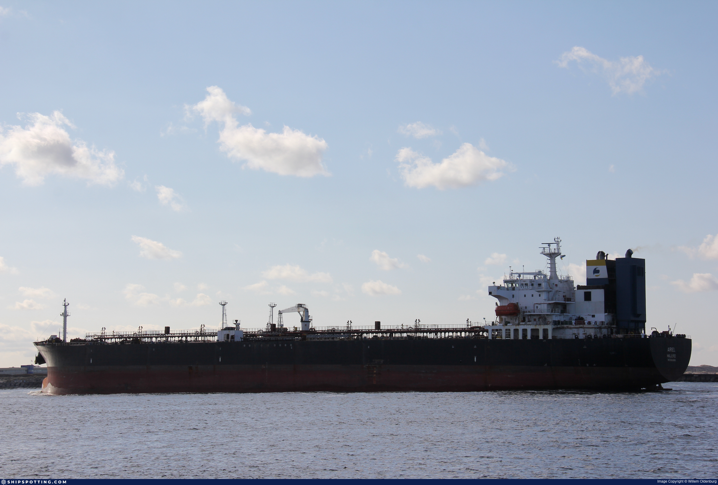
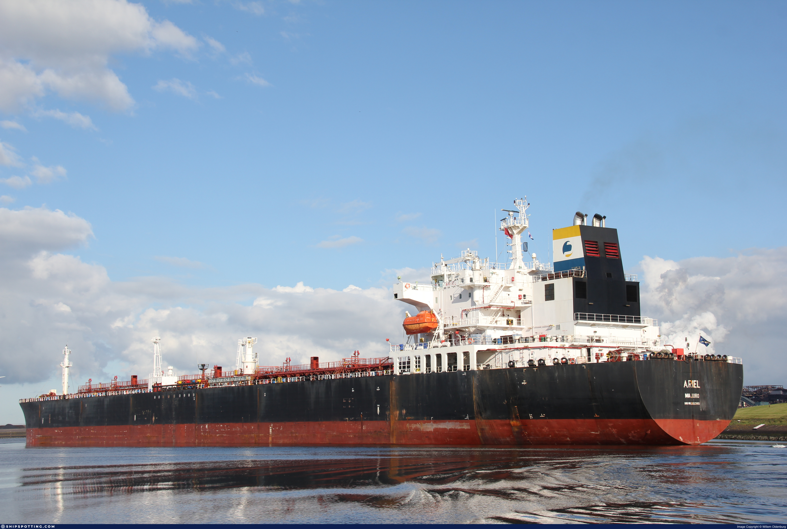
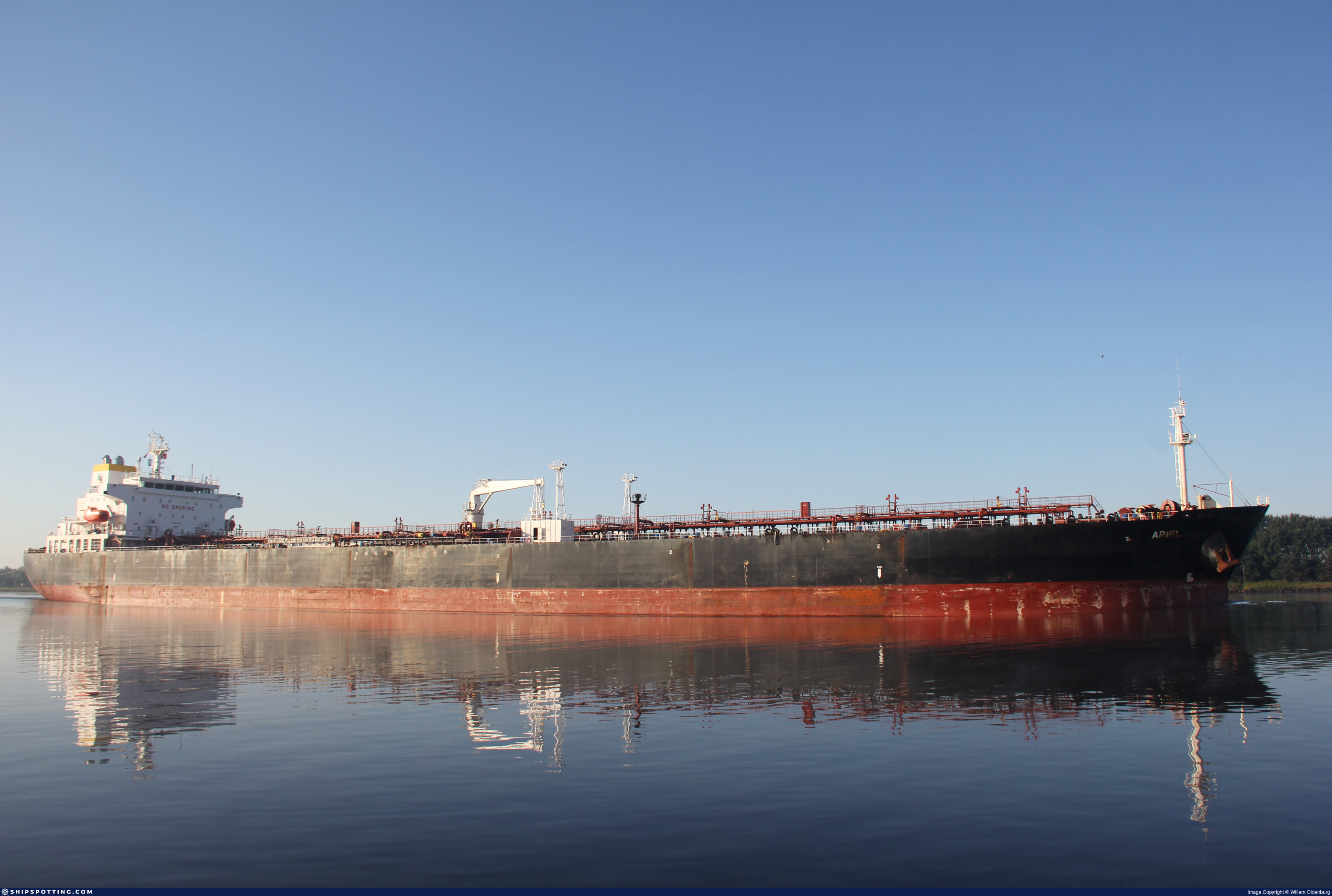
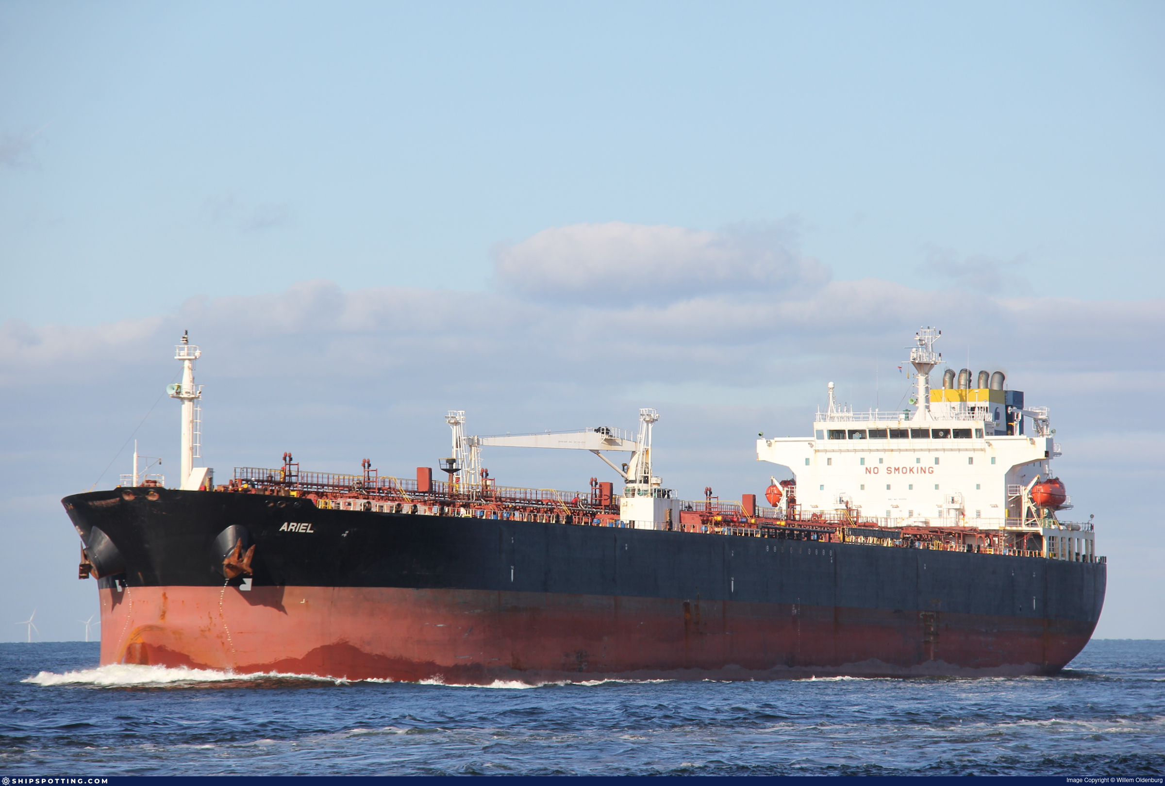
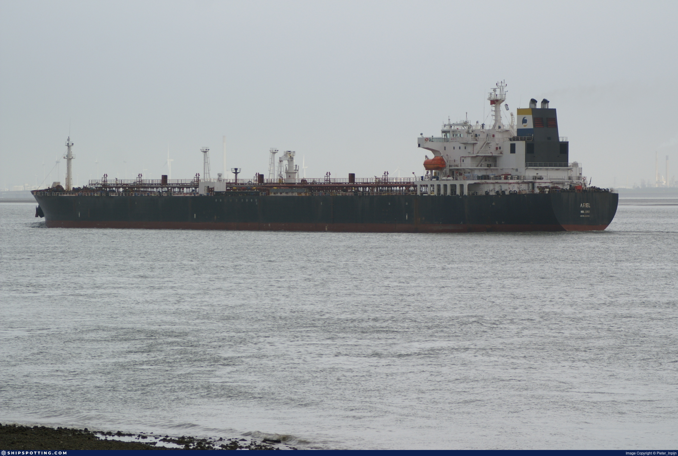
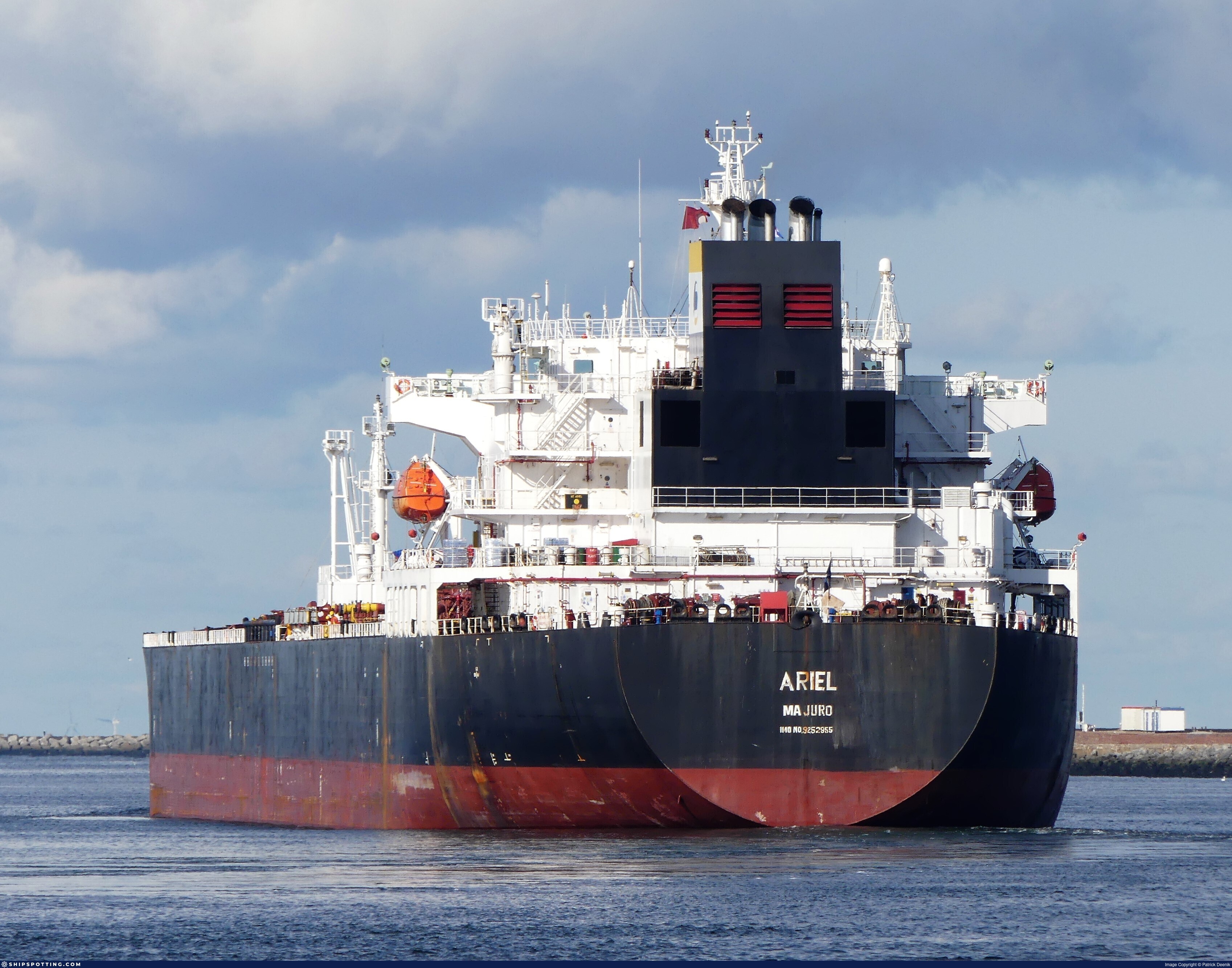
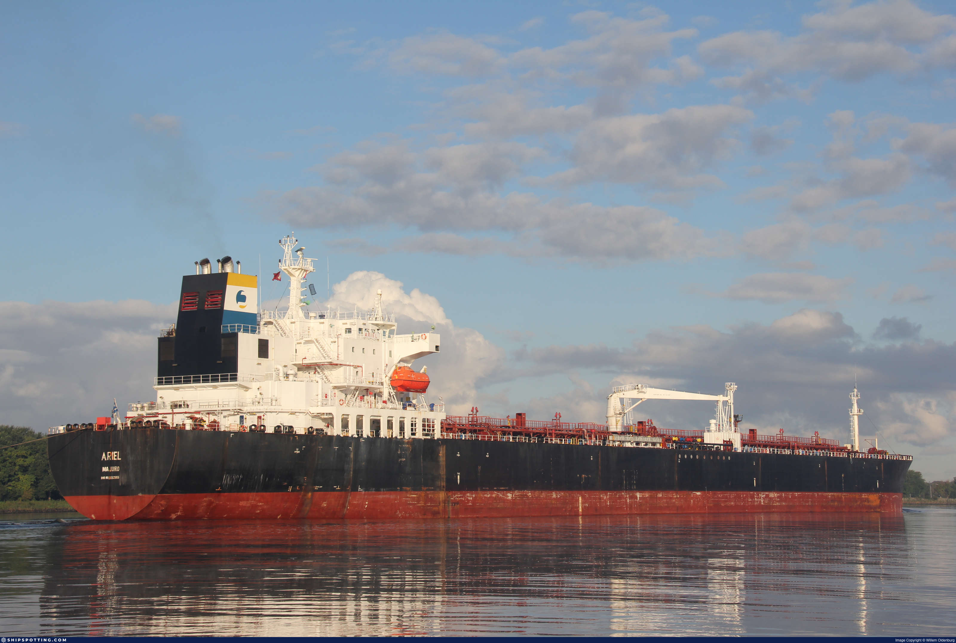
IMO 9252955
Vessel information
Sanctioned by
Company & Ownership
Management & Operations
Classification & Safety
Port State Control (PSC) Inspections
Survey Renewal & Certificates
| Code | Type | Issuer | Issued | Expires |
|---|---|---|---|---|
| 501 | Cargo Ship Safety Construction | Bureau Veritas (BV) (115) | 07/11/2023 | 27/01/2029 |
| 502 | Cargo Ship Safety Equipment | Bureau Veritas (BV) (115) | 07/11/2023 | 27/01/2029 |
Programs & Notes
EU Russia Sanctions – Shadow Fleet | SEMA (Canada) — vessel designations | The Russia (Sanctions) (EU Exit) Regulations 2019
Vessel Changes


AIS Events
50 events detected • 14 zones • Last: Jul 18, 2026
- Zone: Northern Baltic Sea Surveillance Zone
- Duration: 1h 2m
- Data Points: 5 AIS positions
- Period: 2026-07-18T02:52:35+00:00 to 2026-07-18T03:54:35+00:00
Show Raw Evidence JSON
{
    "zone_id": "discovered_031",
    "zone_name": "Northern Baltic Sea Surveillance Zone",
    "dwell_minutes": 62,
    "points_in_zone": 5,
    "first_point": {
        "ts": "2026-07-18T02:52:35+00:00",
        "lat": 41.46846000000000032059688237495720386505126953125,
        "lon": 29.57536830000000094287315732799470424652099609375
    },
    "last_point": {
        "ts": "2026-07-18T03:54:35+00:00",
        "lat": 41.5009117000000031794115784578025341033935546875,
        "lon": 29.551963300000000600675775785930454730987548828125
    }
}- Zone: Bosphorus/Dardanelles Approach
- Duration: 1h 30m
- Data Points: 27 AIS positions
- Period: 2026-06-20T12:12:38+00:00 to 2026-06-20T13:43:28+00:00
Show Raw Evidence JSON
{
    "zone_id": "osint_bosphorus",
    "zone_name": "Bosphorus\/Dardanelles Approach",
    "dwell_minutes": 90.7999999999999971578290569595992565155029296875,
    "points_in_zone": 27,
    "first_point": {
        "ts": "2026-06-20T12:12:38+00:00",
        "lat": 41.12081169999999730180206825025379657745361328125,
        "lon": 29.07603830000000044719854486174881458282470703125
    },
    "last_point": {
        "ts": "2026-06-20T13:43:28+00:00",
        "lat": 41.3465699999999998226485331542789936065673828125,
        "lon": 29.2484816999999992503944667987525463104248046875
    }
}- Zone: Istanbul Black Sea Surveillance Zone
- Duration: 1h 30m
- Data Points: 27 AIS positions
- Period: 2026-06-20T12:12:38+00:00 to 2026-06-20T13:43:28+00:00
Show Raw Evidence JSON
{
    "zone_id": "discovered_024",
    "zone_name": "Istanbul Black Sea Surveillance Zone",
    "dwell_minutes": 90.7999999999999971578290569595992565155029296875,
    "points_in_zone": 27,
    "first_point": {
        "ts": "2026-06-20T12:12:38+00:00",
        "lat": 41.12081169999999730180206825025379657745361328125,
        "lon": 29.07603830000000044719854486174881458282470703125
    },
    "last_point": {
        "ts": "2026-06-20T13:43:28+00:00",
        "lat": 41.3465699999999998226485331542789936065673828125,
        "lon": 29.2484816999999992503944667987525463104248046875
    }
}- Zone: Istanbul Black Sea Surveillance Zone
- Duration: 2h 13m
- Data Points: 28 AIS positions
- Period: 2026-06-20T11:30:29+00:00 to 2026-06-20T13:43:28+00:00
Show Raw Evidence JSON
{
    "zone_id": "discovered_024",
    "zone_name": "Istanbul Black Sea Surveillance Zone",
    "dwell_minutes": 133,
    "points_in_zone": 28,
    "first_point": {
        "ts": "2026-06-20T11:30:29+00:00",
        "lat": 41.0260200000000025966073735617101192474365234375,
        "lon": 29.000955000000001149373929365538060665130615234375
    },
    "last_point": {
        "ts": "2026-06-20T13:43:28+00:00",
        "lat": 41.3465699999999998226485331542789936065673828125,
        "lon": 29.2484816999999992503944667987525463104248046875
    }
}- Zone: Bosphorus/Dardanelles Approach
- Duration: 2h 39m
- Data Points: 33 AIS positions
- Period: 2026-06-20T11:04:28+00:00 to 2026-06-20T13:43:28+00:00
Show Raw Evidence JSON
{
    "zone_id": "osint_bosphorus",
    "zone_name": "Bosphorus\/Dardanelles Approach",
    "dwell_minutes": 159,
    "points_in_zone": 33,
    "first_point": {
        "ts": "2026-06-20T11:04:28+00:00",
        "lat": 40.96667670000000072150214691646397113800048828125,
        "lon": 28.988021700000000890895535121671855449676513671875
    },
    "last_point": {
        "ts": "2026-06-20T13:43:28+00:00",
        "lat": 41.3465699999999998226485331542789936065673828125,
        "lon": 29.2484816999999992503944667987525463104248046875
    }
}- Zone: Bosphorus/Dardanelles Approach
- Duration: 3h 42m
- Data Points: 46 AIS positions
- Period: 2026-06-20T10:01:28+00:00 to 2026-06-20T13:43:28+00:00
Show Raw Evidence JSON
{
    "zone_id": "osint_bosphorus",
    "zone_name": "Bosphorus\/Dardanelles Approach",
    "dwell_minutes": 222,
    "points_in_zone": 46,
    "first_point": {
        "ts": "2026-06-20T10:01:28+00:00",
        "lat": 40.8396766999999982772351359017193317413330078125,
        "lon": 28.840786699999998887733454466797411441802978515625
    },
    "last_point": {
        "ts": "2026-06-20T13:43:28+00:00",
        "lat": 41.3465699999999998226485331542789936065673828125,
        "lon": 29.2484816999999992503944667987525463104248046875
    }
}- Zone: Bosphorus/Dardanelles Approach
- Duration: 4h 22m
- Data Points: 47 AIS positions
- Period: 2026-06-20T09:20:49+00:00 to 2026-06-20T13:43:28+00:00
Show Raw Evidence JSON
{
    "zone_id": "osint_bosphorus",
    "zone_name": "Bosphorus\/Dardanelles Approach",
    "dwell_minutes": 262.6000000000000227373675443232059478759765625,
    "points_in_zone": 47,
    "first_point": {
        "ts": "2026-06-20T09:20:49+00:00",
        "lat": 40.76312169999999923675204627215862274169921875,
        "lon": 28.750608299999999672991179977543652057647705078125
    },
    "last_point": {
        "ts": "2026-06-20T13:43:28+00:00",
        "lat": 41.3465699999999998226485331542789936065673828125,
        "lon": 29.2484816999999992503944667987525463104248046875
    }
}- Zone: Bosphorus/Dardanelles Approach
- Duration: 1h 6m
- Data Points: 9 AIS positions
- Period: 2026-06-19T13:01:31+00:00 to 2026-06-19T14:07:48+00:00
Show Raw Evidence JSON
{
    "zone_id": "osint_bosphorus",
    "zone_name": "Bosphorus\/Dardanelles Approach",
    "dwell_minutes": 66.2999999999999971578290569595992565155029296875,
    "points_in_zone": 9,
    "first_point": {
        "ts": "2026-06-19T13:01:31+00:00",
        "lat": 40.9202082999999987578121363185346126556396484375,
        "lon": 28.695595000000000851514414534904062747955322265625
    },
    "last_point": {
        "ts": "2026-06-19T14:07:48+00:00",
        "lat": 40.786703299999999217106960713863372802734375,
        "lon": 28.7416817000000008874849299900233745574951171875
    }
}- Zone: Bosphorus/Dardanelles Approach
- Duration: 2h 57m
- Data Points: 10 AIS positions
- Period: 2026-06-19T11:10:06+00:00 to 2026-06-19T14:07:48+00:00
Show Raw Evidence JSON
{
    "zone_id": "osint_bosphorus",
    "zone_name": "Bosphorus\/Dardanelles Approach",
    "dwell_minutes": 177.69999999999998863131622783839702606201171875,
    "points_in_zone": 10,
    "first_point": {
        "ts": "2026-06-19T11:10:06+00:00",
        "lat": 40.9558099999999996043698047287762165069580078125,
        "lon": 28.722261700000000672616806696169078350067138671875
    },
    "last_point": {
        "ts": "2026-06-19T14:07:48+00:00",
        "lat": 40.786703299999999217106960713863372802734375,
        "lon": 28.7416817000000008874849299900233745574951171875
    }
}- Zone: Bosphorus/Dardanelles Approach
- Duration: 3h 33m
- Data Points: 12 AIS positions
- Period: 2026-06-19T10:34:05+00:00 to 2026-06-19T14:07:48+00:00
Show Raw Evidence JSON
{
    "zone_id": "osint_bosphorus",
    "zone_name": "Bosphorus\/Dardanelles Approach",
    "dwell_minutes": 213.69999999999998863131622783839702606201171875,
    "points_in_zone": 12,
    "first_point": {
        "ts": "2026-06-19T10:34:05+00:00",
        "lat": 40.95606169999999934816514723934233188629150390625,
        "lon": 28.7218850000000003319655661471188068389892578125
    },
    "last_point": {
        "ts": "2026-06-19T14:07:48+00:00",
        "lat": 40.786703299999999217106960713863372802734375,
        "lon": 28.7416817000000008874849299900233745574951171875
    }
}- Zone: Bosphorus/Dardanelles Approach
- Duration: 4h 51m
- Data Points: 15 AIS positions
- Period: 2026-06-19T09:16:02+00:00 to 2026-06-19T14:07:48+00:00
Show Raw Evidence JSON
{
    "zone_id": "osint_bosphorus",
    "zone_name": "Bosphorus\/Dardanelles Approach",
    "dwell_minutes": 291.80000000000001136868377216160297393798828125,
    "points_in_zone": 15,
    "first_point": {
        "ts": "2026-06-19T09:16:02+00:00",
        "lat": 40.95595329999999734127413830719888210296630859375,
        "lon": 28.722288299999998884004526189528405666351318359375
    },
    "last_point": {
        "ts": "2026-06-19T14:07:48+00:00",
        "lat": 40.786703299999999217106960713863372802734375,
        "lon": 28.7416817000000008874849299900233745574951171875
    }
}- Duration: 3h 9m
- Radius: 40 meters
- Data Points: 11 AIS positions
- Centroid: 40.9561, 28.7220
- Zone: Bosphorus/Dardanelles Approach
Show Raw Evidence JSON
{
    "radius_m": 39.89999999999999857891452847979962825775146484375,
    "duration_minutes": 189,
    "points": 11,
    "centroid": {
        "lat": 40.95611302727272828860805020667612552642822265625,
        "lon": 28.7220069636363604104190017096698284149169921875
    },
    "bbox": {
        "min_lat": 40.9558099999999996043698047287762165069580078125,
        "min_lon": 28.72179330000000163636286742985248565673828125,
        "max_lat": 40.9563332999999971661964082159101963043212890625,
        "max_lon": 28.722358299999999786678017699159681797027587890625
    },
    "zone_id": "osint_bosphorus"
}- Zone: Bosphorus/Dardanelles Approach
- Duration: 6h 6m
- Data Points: 20 AIS positions
- Period: 2026-06-19T08:01:08+00:00 to 2026-06-19T14:07:48+00:00
Show Raw Evidence JSON
{
    "zone_id": "osint_bosphorus",
    "zone_name": "Bosphorus\/Dardanelles Approach",
    "dwell_minutes": 366.69999999999998863131622783839702606201171875,
    "points_in_zone": 20,
    "first_point": {
        "ts": "2026-06-19T08:01:08+00:00",
        "lat": 40.95604329999999748679329059086740016937255859375,
        "lon": 28.721849999999999880628820392303168773651123046875
    },
    "last_point": {
        "ts": "2026-06-19T14:07:48+00:00",
        "lat": 40.786703299999999217106960713863372802734375,
        "lon": 28.7416817000000008874849299900233745574951171875
    }
}- Duration: 3h 12m
- Radius: 39 meters
- Data Points: 12 AIS positions
- Centroid: 40.9561, 28.7220
- Zone: Bosphorus/Dardanelles Approach
Show Raw Evidence JSON
{
    "radius_m": 38.60000000000000142108547152020037174224853515625,
    "duration_minutes": 192.099999999999994315658113919198513031005859375,
    "points": 12,
    "centroid": {
        "lat": 40.95610249999999297187969204969704151153564453125,
        "lon": 28.722013883333328720937061007134616374969482421875
    },
    "bbox": {
        "min_lat": 40.9558099999999996043698047287762165069580078125,
        "min_lon": 28.72179330000000163636286742985248565673828125,
        "max_lat": 40.9563332999999971661964082159101963043212890625,
        "max_lon": 28.722358299999999786678017699159681797027587890625
    },
    "zone_id": "osint_bosphorus"
}- Zone: Bosphorus/Dardanelles Approach
- Duration: 6h 9m
- Data Points: 21 AIS positions
- Period: 2026-06-19T07:58:01+00:00 to 2026-06-19T14:07:48+00:00
Show Raw Evidence JSON
{
    "zone_id": "osint_bosphorus",
    "zone_name": "Bosphorus\/Dardanelles Approach",
    "dwell_minutes": 369.80000000000001136868377216160297393798828125,
    "points_in_zone": 21,
    "first_point": {
        "ts": "2026-06-19T07:58:01+00:00",
        "lat": 40.9559866999999968584234011359512805938720703125,
        "lon": 28.72209000000000145291778608225286006927490234375
    },
    "last_point": {
        "ts": "2026-06-19T14:07:48+00:00",
        "lat": 40.786703299999999217106960713863372802734375,
        "lon": 28.7416817000000008874849299900233745574951171875
    }
}- Duration: 6h 21m
- Radius: 63 meters
- Data Points: 12 AIS positions
- Centroid: 40.9561, 28.7220
- Zone: Bosphorus/Dardanelles Approach
Show Raw Evidence JSON
{
    "radius_m": 62.5,
    "duration_minutes": 381,
    "points": 12,
    "centroid": {
        "lat": 40.95610360833332919128224602900445461273193359375,
        "lon": 28.722049849999994108884493471123278141021728515625
    },
    "bbox": {
        "min_lat": 40.95582329999999871006366447545588016510009765625,
        "min_lon": 28.72179330000000163636286742985248565673828125,
        "max_lat": 40.9563332999999971661964082159101963043212890625,
        "max_lon": 28.722693299999999538840711466036736965179443359375
    },
    "zone_id": "osint_bosphorus"
}- Zone: Bosphorus/Dardanelles Approach
- Duration: 6h 21m
- Data Points: 12 AIS positions
- Period: 2026-06-19T04:19:03+00:00 to 2026-06-19T10:40:05+00:00
Show Raw Evidence JSON
{
    "zone_id": "osint_bosphorus",
    "zone_name": "Bosphorus\/Dardanelles Approach",
    "dwell_minutes": 381,
    "points_in_zone": 12,
    "first_point": {
        "ts": "2026-06-19T04:19:03+00:00",
        "lat": 40.95582329999999871006366447545588016510009765625,
        "lon": 28.722693299999999538840711466036736965179443359375
    },
    "last_point": {
        "ts": "2026-06-19T10:40:05+00:00",
        "lat": 40.9562267000000019834260456264019012451171875,
        "lon": 28.721934999999998439079718082211911678314208984375
    }
}- Duration: 6h 30m
- Radius: 55 meters
- Data Points: 11 AIS positions
- Centroid: 40.9561, 28.7221
- Zone: Bosphorus/Dardanelles Approach
Show Raw Evidence JSON
{
    "radius_m": 54.7000000000000028421709430404007434844970703125,
    "duration_minutes": 390.1000000000000227373675443232059478759765625,
    "points": 11,
    "centroid": {
        "lat": 40.9560683272727175108229857869446277618408203125,
        "lon": 28.72213195454545342499841353856027126312255859375
    },
    "bbox": {
        "min_lat": 40.95579670000000049867594498209655284881591796875,
        "min_lon": 28.72179330000000163636286742985248565673828125,
        "max_lat": 40.9563332999999971661964082159101963043212890625,
        "max_lon": 28.722693299999999538840711466036736965179443359375
    },
    "zone_id": "osint_bosphorus"
}- Zone: Bosphorus/Dardanelles Approach
- Duration: 6h 30m
- Data Points: 11 AIS positions
- Period: 2026-06-19T03:12:59+00:00 to 2026-06-19T09:43:04+00:00
Show Raw Evidence JSON
{
    "zone_id": "osint_bosphorus",
    "zone_name": "Bosphorus\/Dardanelles Approach",
    "dwell_minutes": 390.1000000000000227373675443232059478759765625,
    "points_in_zone": 11,
    "first_point": {
        "ts": "2026-06-19T03:12:59+00:00",
        "lat": 40.95579670000000049867594498209655284881591796875,
        "lon": 28.722673300000000295995050691999495029449462890625
    },
    "last_point": {
        "ts": "2026-06-19T09:43:04+00:00",
        "lat": 40.9563332999999971661964082159101963043212890625,
        "lon": 28.721881700000000847694536787457764148712158203125
    }
}- Zone: Bosphorus/Dardanelles Approach
- Duration: 4h 18m
- Data Points: 5 AIS positions
- Period: 2026-06-19T00:00:56+00:00 to 2026-06-19T04:19:03+00:00
Show Raw Evidence JSON
{
    "zone_id": "osint_bosphorus",
    "zone_name": "Bosphorus\/Dardanelles Approach",
    "dwell_minutes": 258.1000000000000227373675443232059478759765625,
    "points_in_zone": 5,
    "first_point": {
        "ts": "2026-06-19T00:00:56+00:00",
        "lat": 40.9523549999999971760189509950578212738037109375,
        "lon": 28.71658000000000043883119360543787479400634765625
    },
    "last_point": {
        "ts": "2026-06-19T04:19:03+00:00",
        "lat": 40.95582329999999871006366447545588016510009765625,
        "lon": 28.722693299999999538840711466036736965179443359375
    }
}- Zone: Bosphorus/Dardanelles Approach
- Duration: 5h 15m
- Data Points: 22 AIS positions
- Period: 2026-06-18T23:03:46+00:00 to 2026-06-19T04:19:03+00:00
Show Raw Evidence JSON
{
    "zone_id": "osint_bosphorus",
    "zone_name": "Bosphorus\/Dardanelles Approach",
    "dwell_minutes": 315.30000000000001136868377216160297393798828125,
    "points_in_zone": 22,
    "first_point": {
        "ts": "2026-06-18T23:03:46+00:00",
        "lat": 40.888908299999997097984305582940578460693359375,
        "lon": 28.679359999999999075726009323261678218841552734375
    },
    "last_point": {
        "ts": "2026-06-19T04:19:03+00:00",
        "lat": 40.95582329999999871006366447545588016510009765625,
        "lon": 28.722693299999999538840711466036736965179443359375
    }
}- Zone: Bosphorus/Dardanelles Approach
- Duration: 6h 17m
- Data Points: 45 AIS positions
- Period: 2026-06-18T22:01:56+00:00 to 2026-06-19T04:19:03+00:00
Show Raw Evidence JSON
{
    "zone_id": "osint_bosphorus",
    "zone_name": "Bosphorus\/Dardanelles Approach",
    "dwell_minutes": 377.1000000000000227373675443232059478759765625,
    "points_in_zone": 45,
    "first_point": {
        "ts": "2026-06-18T22:01:56+00:00",
        "lat": 40.81743829999999917390596237964928150177001953125,
        "lon": 28.5029482999999999037754605524241924285888671875
    },
    "last_point": {
        "ts": "2026-06-19T04:19:03+00:00",
        "lat": 40.95582329999999871006366447545588016510009765625,
        "lon": 28.722693299999999538840711466036736965179443359375
    }
}- Zone: discovered_098
- Duration: 2h 1m
- Data Points: 47 AIS positions
- Period: 2026-06-16T10:01:17+00:00 to 2026-06-16T12:03:06+00:00
Show Raw Evidence JSON
{
    "zone_id": "discovered_098",
    "zone_name": "Eastern Gulf of Finland Monitoring Zone",
    "dwell_minutes": 121.7999999999999971578290569595992565155029296875,
    "points_in_zone": 47,
    "first_point": {
        "ts": "2026-06-16T10:01:17+00:00",
        "lat": 37.38164830000000193876985576935112476348876953125,
        "lon": 25.9803433000000012498276191763579845428466796875
    },
    "last_point": {
        "ts": "2026-06-16T12:03:06+00:00",
        "lat": 37.6825783000000029687726055271923542022705078125,
        "lon": 25.849386700000000161026036948896944522857666015625
    }
}- Zone: discovered_098
- Duration: 3h 2m
- Data Points: 71 AIS positions
- Period: 2026-06-16T09:00:56+00:00 to 2026-06-16T12:03:06+00:00
Show Raw Evidence JSON
{
    "zone_id": "discovered_098",
    "zone_name": "Eastern Gulf of Finland Monitoring Zone",
    "dwell_minutes": 182.19999999999998863131622783839702606201171875,
    "points_in_zone": 71,
    "first_point": {
        "ts": "2026-06-16T09:00:56+00:00",
        "lat": 37.2979150000000032605385058559477329254150390625,
        "lon": 26.17148999999999858800947549752891063690185546875
    },
    "last_point": {
        "ts": "2026-06-16T12:03:06+00:00",
        "lat": 37.6825783000000029687726055271923542022705078125,
        "lon": 25.849386700000000161026036948896944522857666015625
    }
}- Zone: discovered_098
- Duration: 3h 10m
- Data Points: 75 AIS positions
- Period: 2026-06-16T08:52:37+00:00 to 2026-06-16T12:03:06+00:00
Show Raw Evidence JSON
{
    "zone_id": "discovered_098",
    "zone_name": "Eastern Gulf of Finland Monitoring Zone",
    "dwell_minutes": 190.5,
    "points_in_zone": 75,
    "first_point": {
        "ts": "2026-06-16T08:52:37+00:00",
        "lat": 37.28620670000000103527781902812421321868896484375,
        "lon": 26.197005000000000762838681112043559551239013671875
    },
    "last_point": {
        "ts": "2026-06-16T12:03:06+00:00",
        "lat": 37.6825783000000029687726055271923542022705078125,
        "lon": 25.849386700000000161026036948896944522857666015625
    }
}- Zone: Northeast Aegean Monitoring Zone
- Duration: 1h 26m
- Data Points: 51 AIS positions
- Period: 2026-06-16T07:00:56+00:00 to 2026-06-16T08:27:07+00:00
Show Raw Evidence JSON
{
    "zone_id": "discovered_107",
    "zone_name": "Northeast Aegean Monitoring Zone",
    "dwell_minutes": 86.2000000000000028421709430404007434844970703125,
    "points_in_zone": 51,
    "first_point": {
        "ts": "2026-06-16T07:00:56+00:00",
        "lat": 37.09607170000000309073584503494203090667724609375,
        "lon": 26.554404999999999148485585465095937252044677734375
    },
    "last_point": {
        "ts": "2026-06-16T08:27:07+00:00",
        "lat": 37.24515670000000255868144449777901172637939453125,
        "lon": 26.2740849999999994679455994628369808197021484375
    }
}- Zone: Northeast Aegean Monitoring Zone
- Duration: 2h 23m
- Data Points: 80 AIS positions
- Period: 2026-06-16T06:03:26+00:00 to 2026-06-16T08:27:07+00:00
Show Raw Evidence JSON
{
    "zone_id": "discovered_107",
    "zone_name": "Northeast Aegean Monitoring Zone",
    "dwell_minutes": 143.69999999999998863131622783839702606201171875,
    "points_in_zone": 80,
    "first_point": {
        "ts": "2026-06-16T06:03:26+00:00",
        "lat": 36.9751150000000023965185391716659069061279296875,
        "lon": 26.688894999999998702833181596361100673675537109375
    },
    "last_point": {
        "ts": "2026-06-16T08:27:07+00:00",
        "lat": 37.24515670000000255868144449777901172637939453125,
        "lon": 26.2740849999999994679455994628369808197021484375
    }
}- Zone: Northeast Aegean Monitoring Zone
- Duration: 3h 26m
- Data Points: 104 AIS positions
- Period: 2026-06-16T05:00:26+00:00 to 2026-06-16T08:27:07+00:00
Show Raw Evidence JSON
{
    "zone_id": "discovered_107",
    "zone_name": "Northeast Aegean Monitoring Zone",
    "dwell_minutes": 206.69999999999998863131622783839702606201171875,
    "points_in_zone": 104,
    "first_point": {
        "ts": "2026-06-16T05:00:26+00:00",
        "lat": 36.77860170000000294976416626013815402984619140625,
        "lon": 26.700271699999998276098267524503171443939208984375
    },
    "last_point": {
        "ts": "2026-06-16T08:27:07+00:00",
        "lat": 37.24515670000000255868144449777901172637939453125,
        "lon": 26.2740849999999994679455994628369808197021484375
    }
}- Zone: Northeast Aegean Monitoring Zone
- Duration: 4h 26m
- Data Points: 123 AIS positions
- Period: 2026-06-16T04:00:57+00:00 to 2026-06-16T08:27:07+00:00
Show Raw Evidence JSON
{
    "zone_id": "discovered_107",
    "zone_name": "Northeast Aegean Monitoring Zone",
    "dwell_minutes": 266.19999999999998863131622783839702606201171875,
    "points_in_zone": 123,
    "first_point": {
        "ts": "2026-06-16T04:00:57+00:00",
        "lat": 36.5801450000000016871126717887818813323974609375,
        "lon": 26.7229616999999990412106853909790515899658203125
    },
    "last_point": {
        "ts": "2026-06-16T08:27:07+00:00",
        "lat": 37.24515670000000255868144449777901172637939453125,
        "lon": 26.2740849999999994679455994628369808197021484375
    }
}- Zone: Northeast Aegean Monitoring Zone
- Duration: 4h 46m
- Data Points: 129 AIS positions
- Period: 2026-06-16T03:40:36+00:00 to 2026-06-16T08:27:07+00:00
Show Raw Evidence JSON
{
    "zone_id": "discovered_107",
    "zone_name": "Northeast Aegean Monitoring Zone",
    "dwell_minutes": 286.5,
    "points_in_zone": 129,
    "first_point": {
        "ts": "2026-06-16T03:40:36+00:00",
        "lat": 36.5272532999999981484506861306726932525634765625,
        "lon": 26.77737499999999926103555480949580669403076171875
    },
    "last_point": {
        "ts": "2026-06-16T08:27:07+00:00",
        "lat": 37.24515670000000255868144449777901172637939453125,
        "lon": 26.2740849999999994679455994628369808197021484375
    }
}- Gap Duration: 5h 38m
- Last Seen: 2026-06-15T19:26:37+00:00 at 35.4805, 28.2282 (Zone: discovered_185)
- Next Seen: 2026-06-16T01:04:56+00:00 at 36.1548, 27.2290
🛰️ Gap Corroboration
These are snapshots that may corroborate presence during the gap. They do not reconstruct a continuous route.
SAR Imagery (Sentinel-1)
Status: ✗ No SAR coverage
No Sentinel-1 scenes covering corridor and time window
VIIRS Thermal Anomaly
Status: ✗ No detections
No VIIRS thermal/light detections in corridor
Show Raw Evidence JSON
{
    "gap_minutes": 338.30000000000001136868377216160297393798828125,
    "last_seen": {
        "ts": "2026-06-15T19:26:37+00:00",
        "lat": 35.480469999999996844053384847939014434814453125,
        "lon": 28.22822000000000031150193535722792148590087890625,
        "sog": 11.699999999999999289457264239899814128875732421875,
        "zone_id": "discovered_185"
    },
    "next_seen": {
        "ts": "2026-06-16T01:04:56+00:00",
        "lat": 36.15474999999999994315658113919198513031005859375,
        "lon": 27.22898169999999851143002160824835300445556640625,
        "zone_ids": [
            "discovered_075"
        ]
    },
    "gap_enrichment": {
        "status": "not_found",
        "corridor": {
            "start": {
                "lat": 35.480469999999996844053384847939014434814453125,
                "lon": 28.22822000000000031150193535722792148590087890625,
                "ts": "2026-06-15T19:26:37+00:00"
            },
            "end": {
                "lat": 36.15474999999999994315658113919198513031005859375,
                "lon": 27.22898169999999851143002160824835300445556640625,
                "ts": "2026-06-16T01:04:56+00:00"
            },
            "bbox": {
                "min_lat": 35.30028999999999683723217458464205265045166015625,
                "min_lon": 27.00677999999999912006387603469192981719970703125,
                "max_lat": 36.3349299999999999499777914024889469146728515625,
                "max_lon": 28.450421999999999655983629054389894008636474609375
            },
            "buffer_km": 20
        },
        "sar": {
            "status": "not_found",
            "notes": "No Sentinel-1 scenes covering corridor and time window"
        },
        "viirs": {
            "status": "not_found",
            "notes": "No VIIRS thermal\/light detections in corridor"
        },
        "searched_at": "2026-06-16T01:15:07.738126+00:00"
    }
}- Zone: Gulf of Oman Sanctioned Vessel Monitoring Zone
- Duration: 1h 24m
- Data Points: 17 AIS positions
- Period: 2026-05-24T16:01:09+00:00 to 2026-05-24T17:25:08+00:00
Show Raw Evidence JSON
{
    "zone_id": "discovered_032",
    "zone_name": "Gulf of Oman Sanctioned Vessel Monitoring Zone",
    "dwell_minutes": 84,
    "points_in_zone": 17,
    "first_point": {
        "ts": "2026-05-24T16:01:09+00:00",
        "lat": 34.31998999999999711008058511652052402496337890625,
        "lon": 33.577893299999999499050318263471126556396484375
    },
    "last_point": {
        "ts": "2026-05-24T17:25:08+00:00",
        "lat": 34.30999829999999661822585039772093296051025390625,
        "lon": 33.91054669999999759966158308088779449462890625
    }
}- Zone: Gulf of Oman Sanctioned Vessel Monitoring Zone
- Duration: 2h 20m
- Data Points: 42 AIS positions
- Period: 2026-05-24T15:04:20+00:00 to 2026-05-24T17:25:08+00:00
Show Raw Evidence JSON
{
    "zone_id": "discovered_032",
    "zone_name": "Gulf of Oman Sanctioned Vessel Monitoring Zone",
    "dwell_minutes": 140.80000000000001136868377216160297393798828125,
    "points_in_zone": 42,
    "first_point": {
        "ts": "2026-05-24T15:04:20+00:00",
        "lat": 34.31032499999999885176293901167809963226318359375,
        "lon": 33.33766829999999714573277742601931095123291015625
    },
    "last_point": {
        "ts": "2026-05-24T17:25:08+00:00",
        "lat": 34.30999829999999661822585039772093296051025390625,
        "lon": 33.91054669999999759966158308088779449462890625
    }
}- Zone: Gulf of Oman Sanctioned Vessel Monitoring Zone
- Duration: 2h 29m
- Data Points: 45 AIS positions
- Period: 2026-05-24T14:55:11+00:00 to 2026-05-24T17:25:08+00:00
Show Raw Evidence JSON
{
    "zone_id": "discovered_032",
    "zone_name": "Gulf of Oman Sanctioned Vessel Monitoring Zone",
    "dwell_minutes": 149.900000000000005684341886080801486968994140625,
    "points_in_zone": 45,
    "first_point": {
        "ts": "2026-05-24T14:55:11+00:00",
        "lat": 34.31019830000000325753717334009706974029541015625,
        "lon": 33.29847500000000337649908033199608325958251953125
    },
    "last_point": {
        "ts": "2026-05-24T17:25:08+00:00",
        "lat": 34.30999829999999661822585039772093296051025390625,
        "lon": 33.91054669999999759966158308088779449462890625
    }
}- Gap Duration: 4h 30m
- Last Seen: 2026-05-24T10:25:03+00:00 at 34.4062, 32.2015 (Zone: Black Sea Sanctioned Vessel Monitoring Zone)
- Next Seen: 2026-05-24T14:55:11+00:00 at 34.3102, 33.2985
🛰️ Gap Corroboration
These are snapshots that may corroborate presence during the gap. They do not reconstruct a continuous route.
SAR Imagery (Sentinel-1)
Status: ✗ No SAR coverage
No Sentinel-1 scenes covering corridor and time window
VIIRS Thermal Anomaly
Status: ✗ No detections
No VIIRS thermal/light detections in corridor
Show Raw Evidence JSON
{
    "gap_minutes": 270.1000000000000227373675443232059478759765625,
    "last_seen": {
        "ts": "2026-05-24T10:25:03+00:00",
        "lat": 34.4061999999999983401721692644059658050537109375,
        "lon": 32.20150000000000289901436190120875835418701171875,
        "sog": 12.199999999999999289457264239899814128875732421875,
        "zone_id": "discovered_168"
    },
    "next_seen": {
        "ts": "2026-05-24T14:55:11+00:00",
        "lat": 34.31019830000000325753717334009706974029541015625,
        "lon": 33.29847500000000337649908033199608325958251953125,
        "zone_ids": [
            "discovered_032"
        ]
    },
    "gap_enrichment": {
        "status": "not_found",
        "corridor": {
            "start": {
                "lat": 34.4061999999999983401721692644059658050537109375,
                "lon": 32.20150000000000289901436190120875835418701171875,
                "ts": "2026-05-24T10:25:03+00:00"
            },
            "end": {
                "lat": 34.31019830000000325753717334009706974029541015625,
                "lon": 33.29847500000000337649908033199608325958251953125,
                "ts": "2026-05-24T14:55:11+00:00"
            },
            "bbox": {
                "min_lat": 34.13001799999999974488673615269362926483154296875,
                "min_lon": 31.983239000000001084345058188773691654205322265625,
                "max_lat": 34.58637999999999834699337952770292758941650390625,
                "max_lon": 33.51673600000000163845470524393022060394287109375
            },
            "buffer_km": 20
        },
        "sar": {
            "status": "not_found",
            "notes": "No Sentinel-1 scenes covering corridor and time window"
        },
        "viirs": {
            "status": "not_found",
            "notes": "No VIIRS thermal\/light detections in corridor"
        },
        "searched_at": "2026-05-24T15:15:04.853058+00:00"
    }
}- Gap Duration: 6h 9m
- Last Seen: 2026-05-23T06:33:46+00:00 at 36.7257, 26.4343 (Zone: Crimean Peninsula Surveillance Zone)
- Next Seen: 2026-05-23T12:43:17+00:00 at 35.9168, 27.4894
🛰️ Gap Corroboration
These are snapshots that may corroborate presence during the gap. They do not reconstruct a continuous route.
SAR Imagery (Sentinel-1)
Status: ✗ No SAR coverage
No Sentinel-1 scenes covering corridor and time window
VIIRS Thermal Anomaly
Status: ✗ No detections
No VIIRS thermal/light detections in corridor
Show Raw Evidence JSON
{
    "gap_minutes": 369.5,
    "last_seen": {
        "ts": "2026-05-23T06:33:46+00:00",
        "lat": 36.725691699999998718340066261589527130126953125,
        "lon": 26.434266699999998451175997615791857242584228515625,
        "sog": 11.5999999999999996447286321199499070644378662109375,
        "zone_id": "discovered_086"
    },
    "next_seen": {
        "ts": "2026-05-23T12:43:17+00:00",
        "lat": 35.916848299999998062048689462244510650634765625,
        "lon": 27.489354999999999762394509161822497844696044921875,
        "zone_ids": [
            "discovered_070"
        ]
    },
    "gap_enrichment": {
        "status": "not_found",
        "corridor": {
            "start": {
                "lat": 36.725691699999998718340066261589527130126953125,
                "lon": 26.434266699999998451175997615791857242584228515625,
                "ts": "2026-05-23T06:33:46+00:00"
            },
            "end": {
                "lat": 35.916848299999998062048689462244510650634765625,
                "lon": 27.489354999999999762394509161822497844696044921875,
                "ts": "2026-05-23T12:43:17+00:00"
            },
            "bbox": {
                "min_lat": 35.73666800000000165482560987584292888641357421875,
                "min_lon": 26.21063699999999840883901924826204776763916015625,
                "max_lat": 36.9058720000000022309905034489929676055908203125,
                "max_lon": 27.712984999999999757847035652957856655120849609375
            },
            "buffer_km": 20
        },
        "sar": {
            "status": "not_found",
            "notes": "No Sentinel-1 scenes covering corridor and time window"
        },
        "viirs": {
            "status": "not_found",
            "notes": "No VIIRS thermal\/light detections in corridor"
        },
        "searched_at": "2026-05-23T13:00:01.633664+00:00"
    }
}- Gap Duration: 4h 29m
- Last Seen: 2026-05-23T02:04:45+00:00 at 37.4676, 25.8822 (Zone: Central Atlantic Surveillance Zone)
- Next Seen: 2026-05-23T06:33:46+00:00 at 36.7257, 26.4343
🛰️ Gap Corroboration
These are snapshots that may corroborate presence during the gap. They do not reconstruct a continuous route.
SAR Imagery (Sentinel-1)
Status: ✗ No SAR coverage
No Sentinel-1 scenes covering corridor and time window
VIIRS Thermal Anomaly
Status: ✗ No detections
No VIIRS thermal/light detections in corridor
Show Raw Evidence JSON
{
    "gap_minutes": 269,
    "last_seen": {
        "ts": "2026-05-23T02:04:45+00:00",
        "lat": 37.4675500000000027966962079517543315887451171875,
        "lon": 25.882220000000000226236807066015899181365966796875,
        "sog": 11.4000000000000003552713678800500929355621337890625,
        "zone_id": "discovered_088"
    },
    "next_seen": {
        "ts": "2026-05-23T06:33:46+00:00",
        "lat": 36.725691699999998718340066261589527130126953125,
        "lon": 26.434266699999998451175997615791857242584228515625,
        "zone_ids": [
            "discovered_086"
        ]
    },
    "gap_enrichment": {
        "status": "not_found",
        "corridor": {
            "start": {
                "lat": 37.4675500000000027966962079517543315887451171875,
                "lon": 25.882220000000000226236807066015899181365966796875,
                "ts": "2026-05-23T02:04:45+00:00"
            },
            "end": {
                "lat": 36.725691699999998718340066261589527130126953125,
                "lon": 26.434266699999998451175997615791857242584228515625,
                "ts": "2026-05-23T06:33:46+00:00"
            },
            "bbox": {
                "min_lat": 36.545512000000002217348082922399044036865234375,
                "min_lon": 25.6563230000000004338289727456867694854736328125,
                "max_lat": 37.64773000000000280351741821505129337310791015625,
                "max_lon": 26.66016400000000174941305886022746562957763671875
            },
            "buffer_km": 20
        },
        "sar": {
            "status": "not_found",
            "notes": "No Sentinel-1 scenes covering corridor and time window"
        },
        "viirs": {
            "status": "not_found",
            "notes": "No VIIRS thermal\/light detections in corridor"
        },
        "searched_at": "2026-05-23T06:45:04.254329+00:00"
    }
}- Zone: discovered_022
- Duration: 1h 26m
- Data Points: 11 AIS positions
- Period: 2026-05-07T10:06:57+00:00 to 2026-05-07T11:33:28+00:00
Show Raw Evidence JSON
{
    "zone_id": "discovered_022",
    "zone_name": "Black Sea Sanctioned Vessel Monitoring Zone",
    "dwell_minutes": 86.5,
    "points_in_zone": 11,
    "first_point": {
        "ts": "2026-05-07T10:06:57+00:00",
        "lat": 41.3816283000000026959241949953138828277587890625,
        "lon": 29.324954999999999216697688098065555095672607421875
    },
    "last_point": {
        "ts": "2026-05-07T11:33:28+00:00",
        "lat": 41.52861169999999901847331784665584564208984375,
        "lon": 29.6764332999999993489836924709379673004150390625
    }
}- Zone: Bosphorus/Dardanelles Approach
- Duration: 1h 34m
- Data Points: 31 AIS positions
- Period: 2026-05-07T09:04:18+00:00 to 2026-05-07T10:38:17+00:00
Show Raw Evidence JSON
{
    "zone_id": "osint_bosphorus",
    "zone_name": "Bosphorus\/Dardanelles Approach",
    "dwell_minutes": 94,
    "points_in_zone": 31,
    "first_point": {
        "ts": "2026-05-07T09:04:18+00:00",
        "lat": 41.2199566999999973404555930756032466888427734375,
        "lon": 29.13232169999999854326233617030084133148193359375
    },
    "last_point": {
        "ts": "2026-05-07T10:38:17+00:00",
        "lat": 41.43647829999999743222360848449170589447021484375,
        "lon": 29.449756699999998232897269190289080142974853515625
    }
}- Zone: discovered_022
- Duration: 2h 29m
- Data Points: 33 AIS positions
- Period: 2026-05-07T09:04:18+00:00 to 2026-05-07T11:33:28+00:00
Show Raw Evidence JSON
{
    "zone_id": "discovered_022",
    "zone_name": "Black Sea Sanctioned Vessel Monitoring Zone",
    "dwell_minutes": 149.19999999999998863131622783839702606201171875,
    "points_in_zone": 33,
    "first_point": {
        "ts": "2026-05-07T09:04:18+00:00",
        "lat": 41.2199566999999973404555930756032466888427734375,
        "lon": 29.13232169999999854326233617030084133148193359375
    },
    "last_point": {
        "ts": "2026-05-07T11:33:28+00:00",
        "lat": 41.52861169999999901847331784665584564208984375,
        "lon": 29.6764332999999993489836924709379673004150390625
    }
}- Zone: Bosphorus/Dardanelles Approach
- Duration: 3h 27m
- Data Points: 32 AIS positions
- Period: 2026-05-07T07:10:37+00:00 to 2026-05-07T10:38:17+00:00
Show Raw Evidence JSON
{
    "zone_id": "osint_bosphorus",
    "zone_name": "Bosphorus\/Dardanelles Approach",
    "dwell_minutes": 207.69999999999998863131622783839702606201171875,
    "points_in_zone": 32,
    "first_point": {
        "ts": "2026-05-07T07:10:37+00:00",
        "lat": 40.96671500000000065710992203094065189361572265625,
        "lon": 28.9874133000000000492946128360927104949951171875
    },
    "last_point": {
        "ts": "2026-05-07T10:38:17+00:00",
        "lat": 41.43647829999999743222360848449170589447021484375,
        "lon": 29.449756699999998232897269190289080142974853515625
    }
}- Zone: Bosphorus/Dardanelles Approach
- Duration: 4h 16m
- Data Points: 42 AIS positions
- Period: 2026-05-07T06:22:07+00:00 to 2026-05-07T10:38:17+00:00
Show Raw Evidence JSON
{
    "zone_id": "osint_bosphorus",
    "zone_name": "Bosphorus\/Dardanelles Approach",
    "dwell_minutes": 256.19999999999998863131622783839702606201171875,
    "points_in_zone": 42,
    "first_point": {
        "ts": "2026-05-07T06:22:07+00:00",
        "lat": 40.878950000000003228706191293895244598388671875,
        "lon": 28.899723300000001557918949401937425136566162109375
    },
    "last_point": {
        "ts": "2026-05-07T10:38:17+00:00",
        "lat": 41.43647829999999743222360848449170589447021484375,
        "lon": 29.449756699999998232897269190289080142974853515625
    }
}- Zone: Bosphorus/Dardanelles Approach
- Duration: 6h 34m
- Data Points: 24 AIS positions
- Period: 2026-05-07T02:43:27+00:00 to 2026-05-07T09:17:37+00:00
Show Raw Evidence JSON
{
    "zone_id": "osint_bosphorus",
    "zone_name": "Bosphorus\/Dardanelles Approach",
    "dwell_minutes": 394.19999999999998863131622783839702606201171875,
    "points_in_zone": 24,
    "first_point": {
        "ts": "2026-05-07T02:43:27+00:00",
        "lat": 40.86346830000000096561052487231791019439697265625,
        "lon": 28.89265999999999934289007796905934810638427734375
    },
    "last_point": {
        "ts": "2026-05-07T09:17:37+00:00",
        "lat": 41.25718169999999673791535315103828907012939453125,
        "lon": 29.1646716999999995323378243483603000640869140625
    }
}- Zone: Central Mediterranean Sanctions Monitoring Zone
- Duration: 1h 16m
- Data Points: 28 AIS positions
- Period: 2026-04-26T03:09:30+00:00 to 2026-04-26T04:25:48+00:00
Show Raw Evidence JSON
{
    "zone_id": "discovered_091",
    "zone_name": "Central Iberian Sea Monitoring Zone",
    "dwell_minutes": 76.2999999999999971578290569595992565155029296875,
    "points_in_zone": 28,
    "first_point": {
        "ts": "2026-04-26T03:09:30+00:00",
        "lat": 37.38449829999999707297320128418505191802978515625,
        "lon": 25.970678299999999438796294271014630794525146484375
    },
    "last_point": {
        "ts": "2026-04-26T04:25:48+00:00",
        "lat": 37.5285300000000034970071283169090747833251953125,
        "lon": 25.716069999999998429984771064482629299163818359375
    }
}- Zone: Central Mediterranean Sanctions Monitoring Zone
- Duration: 2h 16m
- Data Points: 37 AIS positions
- Period: 2026-04-26T02:09:30+00:00 to 2026-04-26T04:25:48+00:00
Show Raw Evidence JSON
{
    "zone_id": "discovered_091",
    "zone_name": "Central Iberian Sea Monitoring Zone",
    "dwell_minutes": 136.30000000000001136868377216160297393798828125,
    "points_in_zone": 37,
    "first_point": {
        "ts": "2026-04-26T02:09:30+00:00",
        "lat": 37.2806767000000007783455657772719860076904296875,
        "lon": 26.19756170000000139452822622843086719512939453125
    },
    "last_point": {
        "ts": "2026-04-26T04:25:48+00:00",
        "lat": 37.5285300000000034970071283169090747833251953125,
        "lon": 25.716069999999998429984771064482629299163818359375
    }
}- Zone: Southeast Aegean Monitoring Zone
- Duration: 1h 33m
- Data Points: 25 AIS positions
- Period: 2026-04-26T00:02:00+00:00 to 2026-04-26T01:35:30+00:00
Show Raw Evidence JSON
{
    "zone_id": "discovered_083",
    "zone_name": "Southeast Aegean Monitoring Zone",
    "dwell_minutes": 93.5,
    "points_in_zone": 25,
    "first_point": {
        "ts": "2026-04-26T00:02:00+00:00",
        "lat": 37.0599382999999988896888680756092071533203125,
        "lon": 26.662473299999998488374330918304622173309326171875
    },
    "last_point": {
        "ts": "2026-04-26T01:35:30+00:00",
        "lat": 37.21984499999999940200723358429968357086181640625,
        "lon": 26.32515670000000085337887867353856563568115234375
    }
}- Zone: Southeast Aegean Monitoring Zone
- Duration: 2h 34m
- Data Points: 67 AIS positions
- Period: 2026-04-25T23:00:41+00:00 to 2026-04-26T01:35:30+00:00
Show Raw Evidence JSON
{
    "zone_id": "discovered_083",
    "zone_name": "Southeast Aegean Monitoring Zone",
    "dwell_minutes": 154.80000000000001136868377216160297393798828125,
    "points_in_zone": 67,
    "first_point": {
        "ts": "2026-04-25T23:00:41+00:00",
        "lat": 36.8656399999999990768628777004778385162353515625,
        "lon": 26.693670000000000896989149623550474643707275390625
    },
    "last_point": {
        "ts": "2026-04-26T01:35:30+00:00",
        "lat": 37.21984499999999940200723358429968357086181640625,
        "lon": 26.32515670000000085337887867353856563568115234375
    }
}- Zone: Southeast Aegean Monitoring Zone
- Duration: 3h 34m
- Data Points: 79 AIS positions
- Period: 2026-04-25T22:00:41+00:00 to 2026-04-26T01:35:30+00:00
Show Raw Evidence JSON
{
    "zone_id": "discovered_083",
    "zone_name": "Southeast Aegean Monitoring Zone",
    "dwell_minutes": 214.80000000000001136868377216160297393798828125,
    "points_in_zone": 79,
    "first_point": {
        "ts": "2026-04-25T22:00:41+00:00",
        "lat": 36.66145829999999961046341923065483570098876953125,
        "lon": 26.70476670000000041227394831366837024688720703125
    },
    "last_point": {
        "ts": "2026-04-26T01:35:30+00:00",
        "lat": 37.21984499999999940200723358429968357086181640625,
        "lon": 26.32515670000000085337887867353856563568115234375
    }
}- Zone: Southeast Aegean Monitoring Zone
- Duration: 3h 52m
- Data Points: 86 AIS positions
- Period: 2026-04-25T21:43:30+00:00 to 2026-04-26T01:35:30+00:00
Show Raw Evidence JSON
{
    "zone_id": "discovered_083",
    "zone_name": "Southeast Aegean Monitoring Zone",
    "dwell_minutes": 232,
    "points_in_zone": 86,
    "first_point": {
        "ts": "2026-04-25T21:43:30+00:00",
        "lat": 36.60236499999999892906998866237699985504150390625,
        "lon": 26.70851499999999845158527023158967494964599609375
    },
    "last_point": {
        "ts": "2026-04-26T01:35:30+00:00",
        "lat": 37.21984499999999940200723358429968357086181640625,
        "lon": 26.32515670000000085337887867353856563568115234375
    }
}- Zone: Eastern Mediterranean Monitoring Zone
- Duration: 1h 10m
- Data Points: 17 AIS positions
- Period: 2026-03-19T03:17:17+00:00 to 2026-03-19T04:27:43+00:00
Show Raw Evidence JSON
{
    "zone_id": "discovered_037",
    "zone_name": "Istanbul Black Sea Surveillance Zone",
    "dwell_minutes": 70.400000000000005684341886080801486968994140625,
    "points_in_zone": 17,
    "first_point": {
        "ts": "2026-03-19T03:17:17+00:00",
        "lat": 34.2994766999999995960024534724652767181396484375,
        "lon": 33.29049330000000139762050821445882320404052734375
    },
    "last_point": {
        "ts": "2026-03-19T04:27:43+00:00",
        "lat": 34.30209669999999988476702128536999225616455078125,
        "lon": 33.5410432999999983394445735029876232147216796875
    }
}Sanctioned on the same day
- Aditya · IMO 9323314 🇨🇦 CA🇪🇺 EU🇬🇧 UK
- Aleksey Savrasov · IMO 9645061 🇨🇦 CA🇪🇺 EU
- ALTURA · IMO 9292199 🇨🇦 CA🇪🇺 EU🇬🇧 UK
- Anabar · IMO 9194012 🇨🇦 CA
- Apate · IMO 9433016 🇨🇦 CA🇪🇺 EU🇬🇧 UK
- Armada Leader · IMO 9260483 🇨🇦 CA🇪🇺 EU
- Aura 1 · IMO 9472634 🇨🇦 CA🇪🇺 EU🇬🇧 UK
- Bergen T · IMO 8918540 🇨🇦 CA🇪🇺 EU