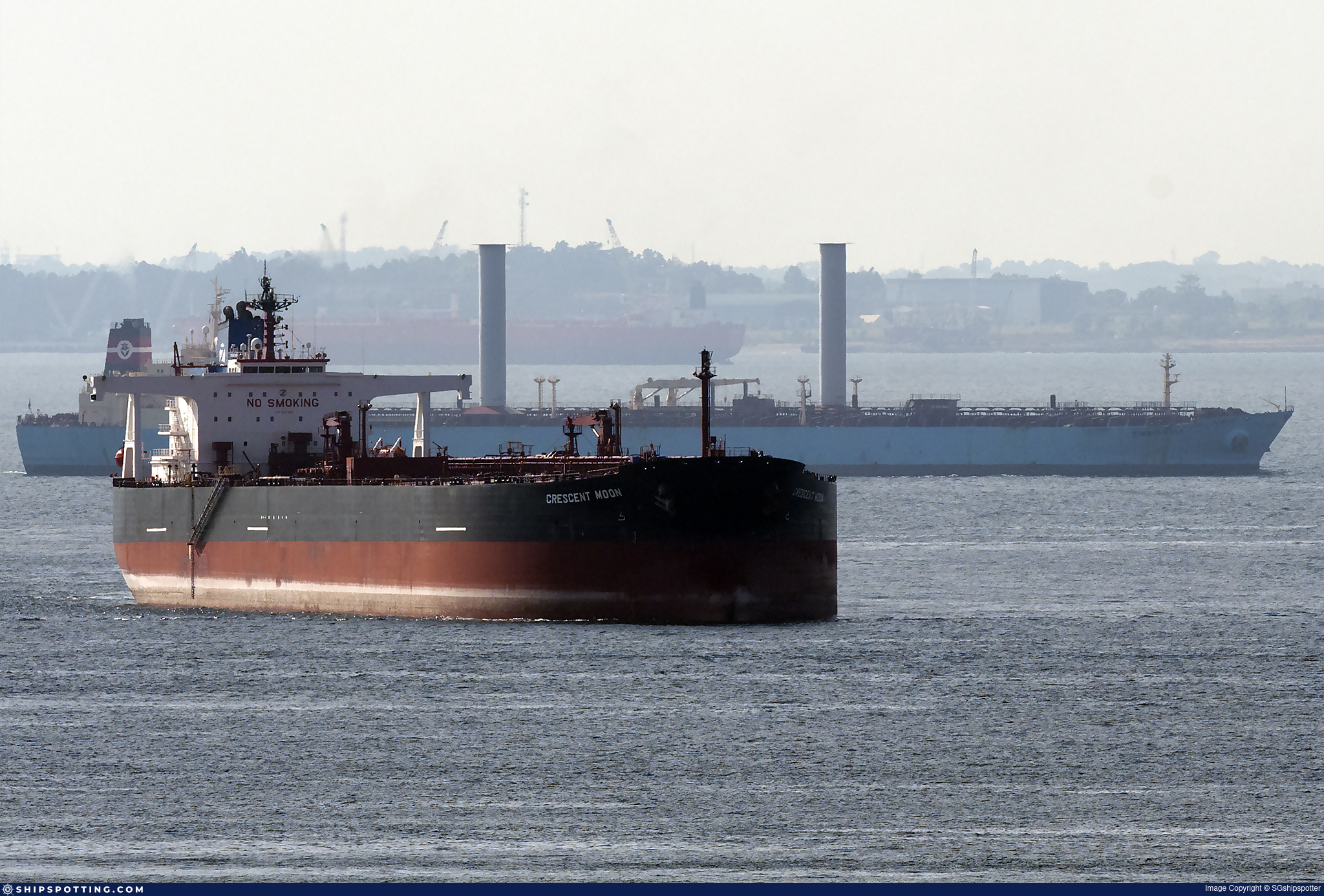
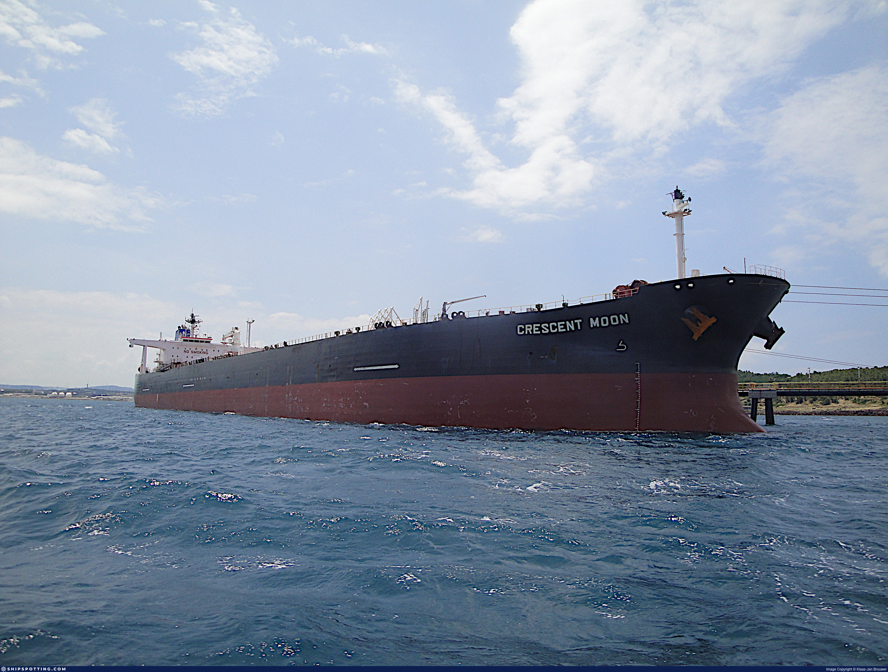
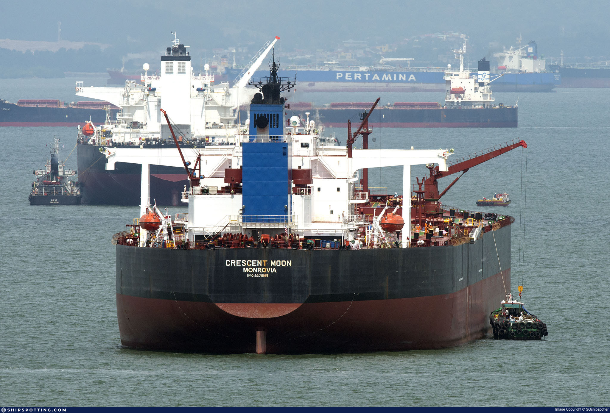
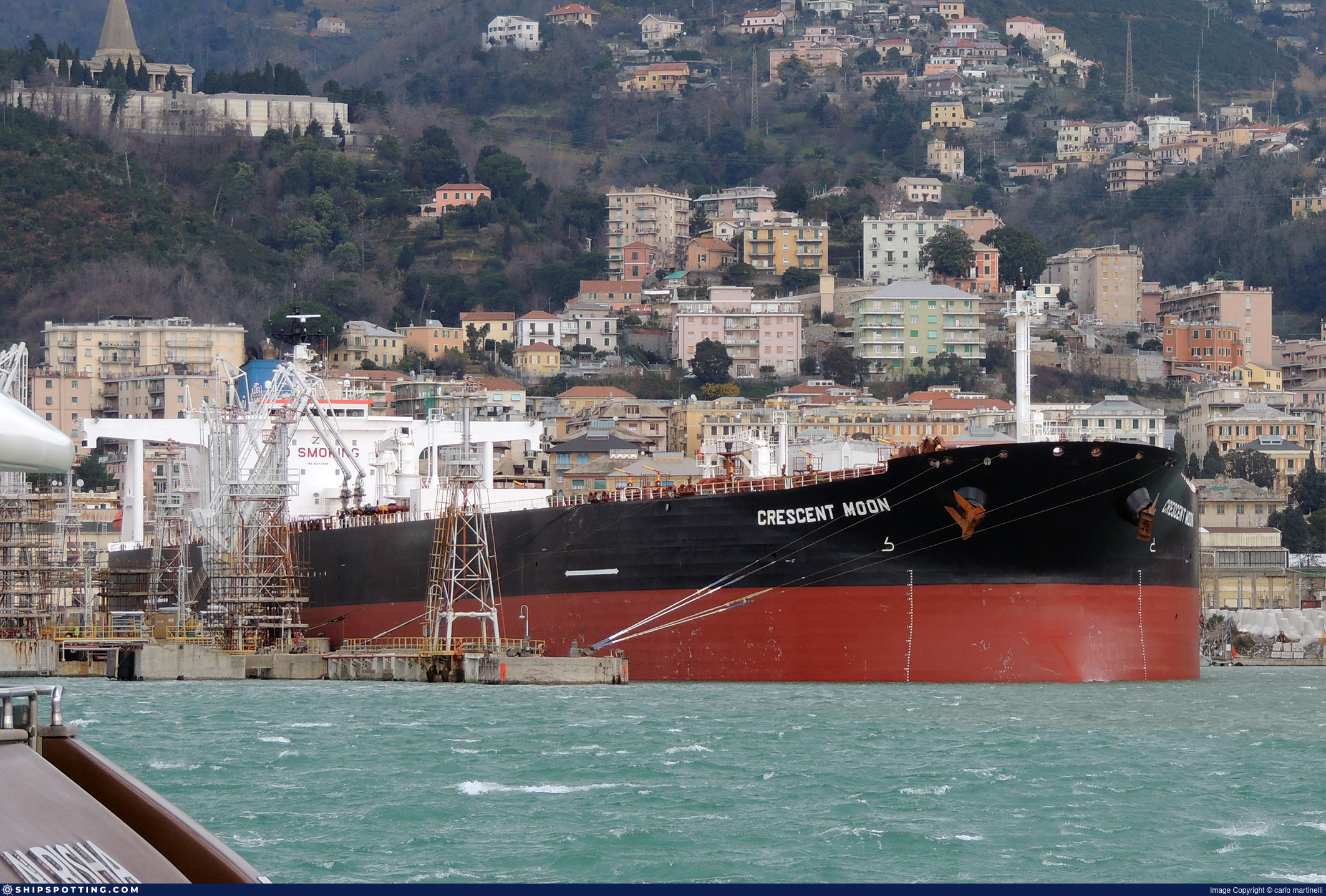
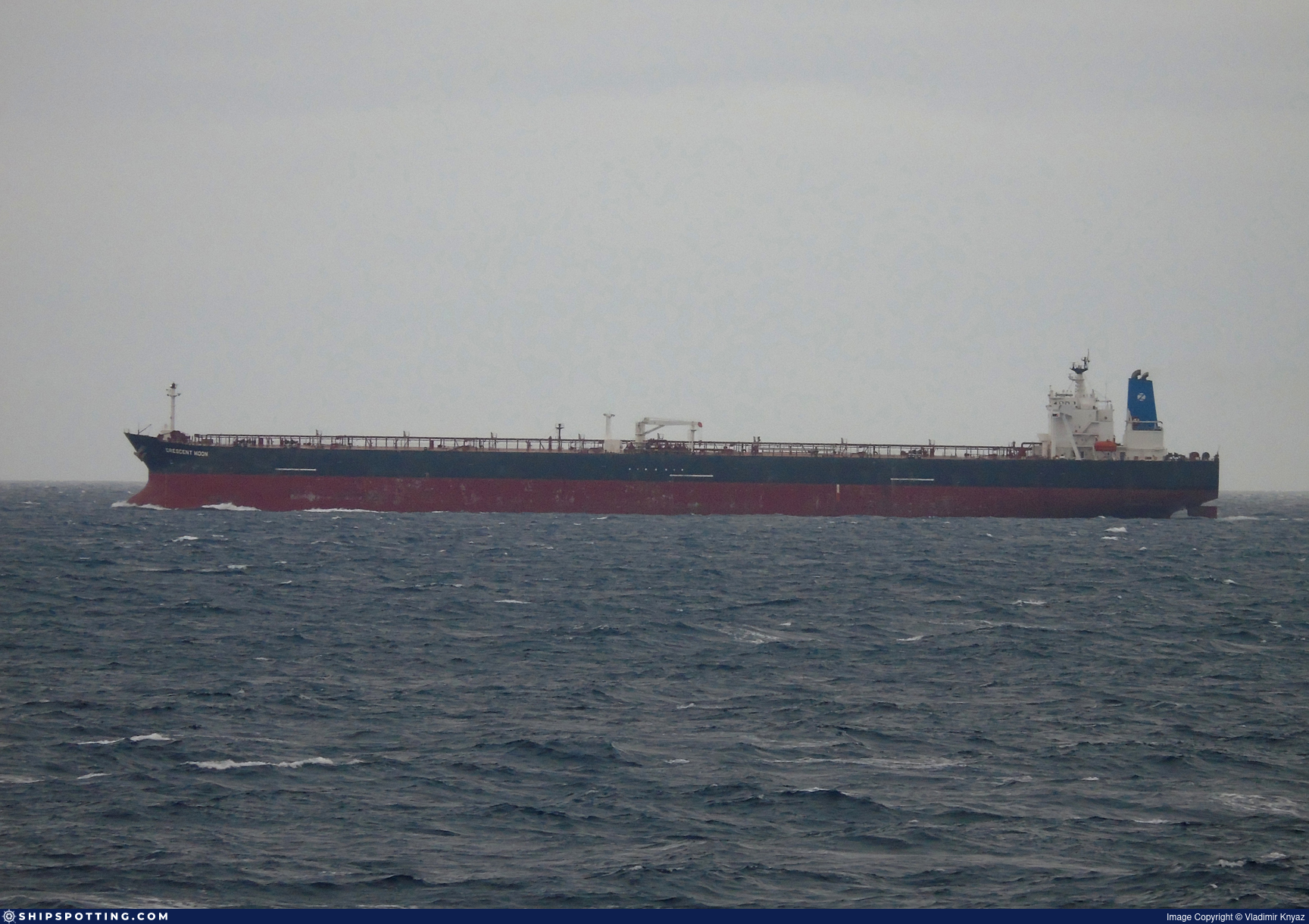
IMO 9271585
Vessel information
Sanctioned by
Company & Ownership
Management & Operations
Classification & Safety
Port State Control (PSC) Inspections
Survey Renewal & Certificates
| Code | Type | Issuer | Issued | Expires |
|---|---|---|---|---|
| 512 | Minimum Safe Manning Document | Gabon (GA) | 14/03/2024 | 12/02/2029 |
| 509 | Document of Compliance | Indian Register of Shipping (150) | 23/11/2023 | 16/11/2028 |
Programs & Notes
SEMA (Canada) — vessel designations | UKRAINE-EO13662] [RUSSIA-EO14024 | The Russia (Sanctions) (EU Exit) Regulations 2019 | Added in EU Sanctions Package 15 | (Council Decision (CFSP) 2024/3187, Annex XVI to Decision 2014/512/CFSP) | Press Release | Official Journal
DateOfListing: 2024-12-17 || Secondary sanctions risk: See Section 11 of Executive Order 14024.; alt. Secondary sanctions risk: Ukraine-/Russia-Related Sanctions Regulations, 31 CFR 589.201 and/or 589.209; Vessel Registration Identification IMO 9271585; MMSI 352004581; Linked To: AMSHA MARITIME. || DateDesignated: 2025-07-21 | Shipping sanctions: (see “Other information”) | Shipping sanctions: a specified ship is prohibited from being provided with access to or having its master or pilot cause it to enter a port in the UK, may have its registration on the UK Ship Register terminated, and a master or pilot of a specified ship may be given a port barring direction, a detention direction, and a port entry direction or a movement direction. | IMO 9271585 (“PRUDENCE”) is, has been or is likely to be involved in activity whose object or effect is to destabilise Ukraine or undermine or threaten the territorial integrity, sovereignty or independence of Ukraine or to obtain a benefit from or support the Government of Russia. Namely, 9271585 is involved in carrying oil or oil products that originated in Russia from Russia to a third country.
Vessel Changes
 🔄 Owner
 🔄 Owner
AIS Events
50 events detected • 2 zones • Last: Jul 16, 2026
- Zone: Archipelago Sea Sanction Zone
- Duration: 1h 8m
- Data Points: 16 AIS positions
- Period: 2026-07-16T03:07:06+00:00 to 2026-07-16T04:15:48+00:00
Show Raw Evidence JSON
{
    "zone_id": "discovered_002",
    "zone_name": "Archipelago Sea Sanction Zone",
    "dwell_minutes": 68.7000000000000028421709430404007434844970703125,
    "points_in_zone": 16,
    "first_point": {
        "ts": "2026-07-16T03:07:06+00:00",
        "lat": 34.89482170000000138543327921070158481597900390625,
        "lon": 130.203744999999997844497556798160076141357421875
    },
    "last_point": {
        "ts": "2026-07-16T04:15:48+00:00",
        "lat": 34.7228716999999988956915331073105335235595703125,
        "lon": 130.059826700000002119850250892341136932373046875
    }
}- Zone: Archipelago Sea Sanction Zone
- Duration: 2h 11m
- Data Points: 26 AIS positions
- Period: 2026-07-16T02:04:07+00:00 to 2026-07-16T04:15:48+00:00
Show Raw Evidence JSON
{
    "zone_id": "discovered_002",
    "zone_name": "Archipelago Sea Sanction Zone",
    "dwell_minutes": 131.69999999999998863131622783839702606201171875,
    "points_in_zone": 26,
    "first_point": {
        "ts": "2026-07-16T02:04:07+00:00",
        "lat": 35.0458066999999999779902282170951366424560546875,
        "lon": 130.33422170000000051004462875425815582275390625
    },
    "last_point": {
        "ts": "2026-07-16T04:15:48+00:00",
        "lat": 34.7228716999999988956915331073105335235595703125,
        "lon": 130.059826700000002119850250892341136932373046875
    }
}- Zone: Archipelago Sea Sanction Zone
- Duration: 2h 28m
- Data Points: 30 AIS positions
- Period: 2026-07-16T01:47:07+00:00 to 2026-07-16T04:15:48+00:00
Show Raw Evidence JSON
{
    "zone_id": "discovered_002",
    "zone_name": "Archipelago Sea Sanction Zone",
    "dwell_minutes": 148.69999999999998863131622783839702606201171875,
    "points_in_zone": 30,
    "first_point": {
        "ts": "2026-07-16T01:47:07+00:00",
        "lat": 35.0839500000000015234036254696547985076904296875,
        "lon": 130.37218830000000480140442959964275360107421875
    },
    "last_point": {
        "ts": "2026-07-16T04:15:48+00:00",
        "lat": 34.7228716999999988956915331073105335235595703125,
        "lon": 130.059826700000002119850250892341136932373046875
    }
}- Zone: Central Mediterranean Sanctions Monitoring Zone
- Duration: 3h 33m
- Data Points: 5 AIS positions
- Period: 2026-04-25T23:01:15+00:00 to 2026-04-26T02:34:14+00:00
Show Raw Evidence JSON
{
    "zone_id": "discovered_016",
    "zone_name": "Eastern Mediterranean Monitoring Zone",
    "dwell_minutes": 213,
    "points_in_zone": 5,
    "first_point": {
        "ts": "2026-04-25T23:01:15+00:00",
        "lat": 31.5168350000000003774403012357652187347412109375,
        "lon": 32.28402330000000119980541057884693145751953125
    },
    "last_point": {
        "ts": "2026-04-26T02:34:14+00:00",
        "lat": 31.5166032999999998764906194992363452911376953125,
        "lon": 32.28452999999999661895344615913927555084228515625
    }
}- Duration: 4h 18m
- Radius: 51 meters
- Data Points: 13 AIS positions
- Centroid: 31.5169, 32.2841
- Zone: Central Mediterranean Sanctions Monitoring Zone
Show Raw Evidence JSON
{
    "radius_m": 51.2999999999999971578290569595992565155029296875,
    "duration_minutes": 258.1000000000000227373675443232059478759765625,
    "points": 13,
    "centroid": {
        "lat": 31.51686423846154383454631897620856761932373046875,
        "lon": 32.2840838461538481851675896905362606048583984375
    },
    "bbox": {
        "min_lat": 31.5166032999999998764906194992363452911376953125,
        "min_lon": 32.28397170000000215850377571769058704376220703125,
        "max_lat": 31.51699169999999838864823686890304088592529296875,
        "max_lon": 32.28452999999999661895344615913927555084228515625
    },
    "zone_id": "discovered_016"
}- Zone: Central Mediterranean Sanctions Monitoring Zone
- Duration: 4h 18m
- Data Points: 13 AIS positions
- Period: 2026-04-25T22:16:10+00:00 to 2026-04-26T02:34:14+00:00
Show Raw Evidence JSON
{
    "zone_id": "discovered_016",
    "zone_name": "Eastern Mediterranean Monitoring Zone",
    "dwell_minutes": 258.1000000000000227373675443232059478759765625,
    "points_in_zone": 13,
    "first_point": {
        "ts": "2026-04-25T22:16:10+00:00",
        "lat": 31.516940000000001731450538500212132930755615234375,
        "lon": 32.284030000000001336957211606204509735107421875
    },
    "last_point": {
        "ts": "2026-04-26T02:34:14+00:00",
        "lat": 31.5166032999999998764906194992363452911376953125,
        "lon": 32.28452999999999661895344615913927555084228515625
    }
}- Duration: 5h 21m
- Radius: 54 meters
- Data Points: 22 AIS positions
- Centroid: 31.5169, 32.2841
- Zone: Central Mediterranean Sanctions Monitoring Zone
Show Raw Evidence JSON
{
    "radius_m": 54.2000000000000028421709430404007434844970703125,
    "duration_minutes": 321.1000000000000227373675443232059478759765625,
    "points": 22,
    "centroid": {
        "lat": 31.51687212272727123263393878005445003509521484375,
        "lon": 32.28405363636364455715010990388691425323486328125
    },
    "bbox": {
        "min_lat": 31.5166032999999998764906194992363452911376953125,
        "min_lon": 32.28396500000000202135197469033300876617431640625,
        "max_lat": 31.51699169999999838864823686890304088592529296875,
        "max_lon": 32.28452999999999661895344615913927555084228515625
    },
    "zone_id": "discovered_016"
}- Zone: Central Mediterranean Sanctions Monitoring Zone
- Duration: 5h 21m
- Data Points: 22 AIS positions
- Period: 2026-04-25T21:13:10+00:00 to 2026-04-26T02:34:14+00:00
Show Raw Evidence JSON
{
    "zone_id": "discovered_016",
    "zone_name": "Eastern Mediterranean Monitoring Zone",
    "dwell_minutes": 321.1000000000000227373675443232059478759765625,
    "points_in_zone": 22,
    "first_point": {
        "ts": "2026-04-25T21:13:10+00:00",
        "lat": 31.516878299999998347402652143500745296478271484375,
        "lon": 32.28400330000000195695974980480968952178955078125
    },
    "last_point": {
        "ts": "2026-04-26T02:34:14+00:00",
        "lat": 31.5166032999999998764906194992363452911376953125,
        "lon": 32.28452999999999661895344615913927555084228515625
    }
}- Duration: 6h 33m
- Radius: 54 meters
- Data Points: 30 AIS positions
- Centroid: 31.5168, 32.2840
- Zone: Central Mediterranean Sanctions Monitoring Zone
Show Raw Evidence JSON
{
    "radius_m": 53.89999999999999857891452847979962825775146484375,
    "duration_minutes": 393.1000000000000227373675443232059478759765625,
    "points": 30,
    "centroid": {
        "lat": 31.516801666666669490268759545870125293731689453125,
        "lon": 32.2840116633333451545695425011217594146728515625
    },
    "bbox": {
        "min_lat": 31.516408299999998376961229951120913028717041015625,
        "min_lon": 32.283833299999997734630596823990345001220703125,
        "max_lat": 31.51699169999999838864823686890304088592529296875,
        "max_lon": 32.28452999999999661895344615913927555084228515625
    },
    "zone_id": "discovered_016"
}- Zone: Central Mediterranean Sanctions Monitoring Zone
- Duration: 6h 33m
- Data Points: 30 AIS positions
- Period: 2026-04-25T20:01:09+00:00 to 2026-04-26T02:34:14+00:00
Show Raw Evidence JSON
{
    "zone_id": "discovered_016",
    "zone_name": "Eastern Mediterranean Monitoring Zone",
    "dwell_minutes": 393.1000000000000227373675443232059478759765625,
    "points_in_zone": 30,
    "first_point": {
        "ts": "2026-04-25T20:01:09+00:00",
        "lat": 31.5164316999999982726876623928546905517578125,
        "lon": 32.283846699999998008934198878705501556396484375
    },
    "last_point": {
        "ts": "2026-04-26T02:34:14+00:00",
        "lat": 31.5166032999999998764906194992363452911376953125,
        "lon": 32.28452999999999661895344615913927555084228515625
    }
}- Duration: 4h 33m
- Radius: 60 meters
- Data Points: 39 AIS positions
- Centroid: 31.5167, 32.2839
- Zone: Central Mediterranean Sanctions Monitoring Zone
Show Raw Evidence JSON
{
    "radius_m": 60.10000000000000142108547152020037174224853515625,
    "duration_minutes": 273.1000000000000227373675443232059478759765625,
    "points": 39,
    "centroid": {
        "lat": 31.516676066666658329040728858672082424163818359375,
        "lon": 32.2839452153846053761299117468297481536865234375
    },
    "bbox": {
        "min_lat": 31.5161532999999991488948580808937549591064453125,
        "min_lon": 32.28377669999999710626070736907422542572021484375,
        "max_lat": 31.51699169999999838864823686890304088592529296875,
        "max_lon": 32.2842050000000000409272615797817707061767578125
    },
    "zone_id": "discovered_016"
}- Zone: Central Mediterranean Sanctions Monitoring Zone
- Duration: 4h 33m
- Data Points: 39 AIS positions
- Period: 2026-04-25T19:01:13+00:00 to 2026-04-25T23:34:17+00:00
Show Raw Evidence JSON
{
    "zone_id": "discovered_016",
    "zone_name": "Eastern Mediterranean Monitoring Zone",
    "dwell_minutes": 273.1000000000000227373675443232059478759765625,
    "points_in_zone": 39,
    "first_point": {
        "ts": "2026-04-25T19:01:13+00:00",
        "lat": 31.5161532999999991488948580808937549591064453125,
        "lon": 32.28377669999999710626070736907422542572021484375
    },
    "last_point": {
        "ts": "2026-04-25T23:34:17+00:00",
        "lat": 31.51699169999999838864823686890304088592529296875,
        "lon": 32.2842050000000000409272615797817707061767578125
    }
}- Duration: 5h 33m
- Radius: 57 meters
- Data Points: 48 AIS positions
- Centroid: 31.5166, 32.2839
- Zone: Central Mediterranean Sanctions Monitoring Zone
Show Raw Evidence JSON
{
    "radius_m": 57.2999999999999971578290569595992565155029296875,
    "duration_minutes": 333.1000000000000227373675443232059478759765625,
    "points": 48,
    "centroid": {
        "lat": 31.5165695479166600989628932438790798187255859375,
        "lon": 32.28391531458333219006817671470344066619873046875
    },
    "bbox": {
        "min_lat": 31.516066699999999656256477464921772480010986328125,
        "min_lon": 32.28377499999999855617716093547642230987548828125,
        "max_lat": 31.51699169999999838864823686890304088592529296875,
        "max_lon": 32.2842050000000000409272615797817707061767578125
    },
    "zone_id": "discovered_016"
}- Zone: Central Mediterranean Sanctions Monitoring Zone
- Duration: 5h 33m
- Data Points: 48 AIS positions
- Period: 2026-04-25T18:01:13+00:00 to 2026-04-25T23:34:17+00:00
Show Raw Evidence JSON
{
    "zone_id": "discovered_016",
    "zone_name": "Eastern Mediterranean Monitoring Zone",
    "dwell_minutes": 333.1000000000000227373675443232059478759765625,
    "points_in_zone": 48,
    "first_point": {
        "ts": "2026-04-25T18:01:13+00:00",
        "lat": 31.516091700000000486170392832718789577484130859375,
        "lon": 32.28378000000000014324541552923619747161865234375
    },
    "last_point": {
        "ts": "2026-04-25T23:34:17+00:00",
        "lat": 31.51699169999999838864823686890304088592529296875,
        "lon": 32.2842050000000000409272615797817707061767578125
    }
}- Duration: 6h 33m
- Radius: 68 meters
- Data Points: 62 AIS positions
- Centroid: 31.5164, 32.2839
- Zone: Central Mediterranean Sanctions Monitoring Zone
Show Raw Evidence JSON
{
    "radius_m": 67.5,
    "duration_minutes": 393.1000000000000227373675443232059478759765625,
    "points": 62,
    "centroid": {
        "lat": 31.516447072580636046268409700132906436920166015625,
        "lon": 32.28388847096773162093086284585297107696533203125
    },
    "bbox": {
        "min_lat": 31.515906699999998608063833671621978282928466796875,
        "min_lon": 32.2837717000000026246198103763163089752197265625,
        "max_lat": 31.51699169999999838864823686890304088592529296875,
        "max_lon": 32.2842050000000000409272615797817707061767578125
    },
    "zone_id": "discovered_016"
}- Zone: Central Mediterranean Sanctions Monitoring Zone
- Duration: 6h 33m
- Data Points: 62 AIS positions
- Period: 2026-04-25T17:01:11+00:00 to 2026-04-25T23:34:17+00:00
Show Raw Evidence JSON
{
    "zone_id": "discovered_016",
    "zone_name": "Eastern Mediterranean Monitoring Zone",
    "dwell_minutes": 393.1000000000000227373675443232059478759765625,
    "points_in_zone": 62,
    "first_point": {
        "ts": "2026-04-25T17:01:11+00:00",
        "lat": 31.515963299999999236433723126538097858428955078125,
        "lon": 32.28379499999999779902282170951366424560546875
    },
    "last_point": {
        "ts": "2026-04-25T23:34:17+00:00",
        "lat": 31.51699169999999838864823686890304088592529296875,
        "lon": 32.2842050000000000409272615797817707061767578125
    }
}- Duration: 6h 21m
- Radius: 68 meters
- Data Points: 64 AIS positions
- Centroid: 31.5164, 32.2839
- Zone: Central Mediterranean Sanctions Monitoring Zone
Show Raw Evidence JSON
{
    "radius_m": 67.5,
    "duration_minutes": 381,
    "points": 64,
    "centroid": {
        "lat": 31.5164108093749888439560891129076480865478515625,
        "lon": 32.283878545312489904972608201205730438232421875
    },
    "bbox": {
        "min_lat": 31.5158050000000002910383045673370361328125,
        "min_lon": 32.283760000000000900399754755198955535888671875,
        "max_lat": 31.5169767000000007328708306886255741119384765625,
        "max_lon": 32.2841149999999998954081092961132526397705078125
    },
    "zone_id": "discovered_016"
}- Zone: Central Mediterranean Sanctions Monitoring Zone
- Duration: 6h 21m
- Data Points: 64 AIS positions
- Period: 2026-04-25T16:52:12+00:00 to 2026-04-25T23:13:10+00:00
Show Raw Evidence JSON
{
    "zone_id": "discovered_016",
    "zone_name": "Eastern Mediterranean Monitoring Zone",
    "dwell_minutes": 381,
    "points_in_zone": 64,
    "first_point": {
        "ts": "2026-04-25T16:52:12+00:00",
        "lat": 31.5158050000000002910383045673370361328125,
        "lon": 32.283805000000000973159330897033214569091796875
    },
    "last_point": {
        "ts": "2026-04-25T23:13:10+00:00",
        "lat": 31.5169266999999990730429999530315399169921875,
        "lon": 32.2841149999999998954081092961132526397705078125
    }
}- Duration: 6h 29m
- Radius: 78 meters
- Data Points: 66 AIS positions
- Centroid: 31.5163, 32.2839
- Zone: Central Mediterranean Sanctions Monitoring Zone
Show Raw Evidence JSON
{
    "radius_m": 77.7000000000000028421709430404007434844970703125,
    "duration_minutes": 389.8999999999999772626324556767940521240234375,
    "points": 66,
    "centroid": {
        "lat": 31.516292325757575554234790615737438201904296875,
        "lon": 32.28388389393939661431431886740028858184814453125
    },
    "bbox": {
        "min_lat": 31.5158050000000002910383045673370361328125,
        "min_lon": 32.283760000000000900399754755198955535888671875,
        "max_lat": 31.5169767000000007328708306886255741119384765625,
        "max_lon": 32.28458330000000131576598505489528179168701171875
    },
    "zone_id": "discovered_016"
}- Minimum Distance: 44 meters
- Average Distance: 91 meters
- Duration: 48 minutes
- Period: 2026-04-25T15:06:44+00:00 to 2026-04-25T15:55:09+00:00
- Vessel A Avg Speed: 1.0 knots
- Vessel B Avg Speed: 1.0 knots
- Zone: Central Mediterranean Sanctions Monitoring Zone
Confidence Analysis
Moderate-confidence STS candidate. Two tankers (KOMANDER and TOA PAYOH) maintained close proximity (min 44m, avg 90m) for 48 minutes. Both vessels were slow-moving (avg speeds 1.0 and 1.0 knots). Moderate distance variation observed during the encounter. Event occurred in Eastern Mediterranean Monitoring Zone, a known STS activity area.
View scoring breakdown
| Factor | Score | Detail |
|---|---|---|
| Distance Tightness | 25/25 | Min distance 44m, avg 90m |
| Duration | 10/25 | Duration 48 minutes |
| Speed Stability | 9/20 | both slow; somewhat variable speeds |
| Distance Consistency | 8/15 | Distance variance ±74m |
| Isolation | 5/10 | Isolation data not available |
| Context | 5/5 | In monitored zone: Eastern Mediterranean Monitoring Zone |
🛰️ Satellite Corroboration
No satellite imagery for this time/location
No Sentinel-1 scenes covering AOI and time window
Show Raw Evidence JSON
{
    "vessel_a": {
        "mmsi": 273274930,
        "imo": 9271585,
        "name": "KOMANDER",
        "flag": "RUSSIA"
    },
    "vessel_b": {
        "mmsi": 647260303,
        "imo": 9298492,
        "name": "TOA PAYOH",
        "flag": "MADAGASCAR"
    },
    "min_distance_m": 43.60000000000000142108547152020037174224853515625,
    "avg_distance_m": 90.5,
    "distance_consistency_m": 74.400000000000005684341886080801486968994140625,
    "duration_minutes": 48.39999999999999857891452847979962825775146484375,
    "overlap_duration_s": 2905,
    "speed_a_avg": 1.0300000000000000266453525910037569701671600341796875,
    "speed_a_std": 0.66000000000000003108624468950438313186168670654296875,
    "speed_b_avg": 1.020000000000000017763568394002504646778106689453125,
    "speed_b_std": 0.770000000000000017763568394002504646778106689453125,
    "speed_summary": {
        "vessel_a": {
            "avg_sog": 1.0300000000000000266453525910037569701671600341796875,
            "max_sog": 1.8000000000000000444089209850062616169452667236328125
        },
        "vessel_b": {
            "avg_sog": 1.020000000000000017763568394002504646778106689453125,
            "max_sog": 1.8000000000000000444089209850062616169452667236328125
        }
    },
    "time_window": {
        "start": "2026-04-25T15:06:44+00:00",
        "end": "2026-04-25T15:55:09+00:00"
    },
    "points_count": {
        "vessel_a": 12,
        "vessel_b": 12
    },
    "zone_id": "discovered_016",
    "zone_name": "Eastern Mediterranean Monitoring Zone",
    "score": {
        "value": 62,
        "components": {
            "distance_tightness": {
                "score": 25,
                "max": 25,
                "detail": "Min distance 44m, avg 90m"
            },
            "duration": {
                "score": 10,
                "max": 25,
                "detail": "Duration 48 minutes"
            },
            "speed_stability": {
                "score": 9,
                "max": 20,
                "detail": "both slow; somewhat variable speeds"
            },
            "distance_consistency": {
                "score": 8,
                "max": 15,
                "detail": "Distance variance \u00b174m"
            },
            "isolation": {
                "score": 5,
                "max": 10,
                "detail": "Isolation data not available"
            },
            "context": {
                "score": 5,
                "max": 5,
                "detail": "In monitored zone: Eastern Mediterranean Monitoring Zone"
            }
        },
        "summary": "Moderate-confidence STS candidate. Two tankers (KOMANDER and TOA PAYOH) maintained close proximity (min 44m, avg 90m) for 48 minutes. Both vessels were slow-moving (avg speeds 1.0 and 1.0 knots). Moderate distance variation observed during the encounter. Event occurred in Eastern Mediterranean Monitoring Zone, a known STS activity area."
    },
    "sar": {
        "status": "not_found",
        "centroid": {
            "lat": 31.514413999999998594603312085382640361785888671875,
            "lon": 32.28130589999999955352905089966952800750732421875
        },
        "time_window": {
            "start_ts": "2026-04-25T15:06:44+00:00",
            "end_ts": "2026-04-25T15:55:09+00:00"
        },
        "searched_at": "2026-04-25T21:45:09.198493+00:00",
        "notes": "No Sentinel-1 scenes covering AOI and time window"
    }
}- Zone: Central Mediterranean Sanctions Monitoring Zone
- Duration: 6h 29m
- Data Points: 66 AIS positions
- Period: 2026-04-25T15:52:13+00:00 to 2026-04-25T22:22:10+00:00
Show Raw Evidence JSON
{
    "zone_id": "discovered_016",
    "zone_name": "Eastern Mediterranean Monitoring Zone",
    "dwell_minutes": 389.8999999999999772626324556767940521240234375,
    "points_in_zone": 66,
    "first_point": {
        "ts": "2026-04-25T15:52:13+00:00",
        "lat": 31.516226700000000704449121258221566677093505859375,
        "lon": 32.28458330000000131576598505489528179168701171875
    },
    "last_point": {
        "ts": "2026-04-25T22:22:10+00:00",
        "lat": 31.516896700000000208774508791975677013397216796875,
        "lon": 32.28401999999999816282070241868495941162109375
    }
}- Minimum Distance: 44 meters
- Average Distance: 111 meters
- Duration: 57 minutes
- Period: 2026-04-25T14:57:13+00:00 to 2026-04-25T15:55:09+00:00
- Vessel A Avg Speed: 1.1 knots
- Vessel B Avg Speed: 1.1 knots
- Zone: Central Mediterranean Sanctions Monitoring Zone
Confidence Analysis
Moderate-confidence STS candidate. Two tankers (KOMANDER and TOA PAYOH) maintained close proximity (min 44m, avg 110m) for 58 minutes. Both vessels were slow-moving (avg speeds 1.1 and 1.1 knots). Moderate distance variation observed during the encounter. Event occurred in Eastern Mediterranean Monitoring Zone, a known STS activity area.
View scoring breakdown
| Factor | Score | Detail |
|---|---|---|
| Distance Tightness | 25/25 | Min distance 44m, avg 110m |
| Duration | 10/25 | Duration 58 minutes |
| Speed Stability | 9/20 | both slow; somewhat variable speeds |
| Distance Consistency | 8/15 | Distance variance ±94m |
| Isolation | 5/10 | Isolation data not available |
| Context | 5/5 | In monitored zone: Eastern Mediterranean Monitoring Zone |
🛰️ Satellite Corroboration
No satellite imagery for this time/location
No Sentinel-1 scenes covering AOI and time window
Show Raw Evidence JSON
{
    "vessel_a": {
        "mmsi": 273274930,
        "imo": 9271585,
        "name": "KOMANDER",
        "flag": "RUSSIA"
    },
    "vessel_b": {
        "mmsi": 647260303,
        "imo": 9298492,
        "name": "TOA PAYOH",
        "flag": "MADAGASCAR"
    },
    "min_distance_m": 43.60000000000000142108547152020037174224853515625,
    "avg_distance_m": 110.5,
    "distance_consistency_m": 94.2000000000000028421709430404007434844970703125,
    "duration_minutes": 57.89999999999999857891452847979962825775146484375,
    "overlap_duration_s": 3476,
    "speed_a_avg": 1.1399999999999999023003738329862244427204132080078125,
    "speed_a_std": 0.67000000000000003996802888650563545525074005126953125,
    "speed_b_avg": 1.12999999999999989341858963598497211933135986328125,
    "speed_b_std": 0.7600000000000000088817841970012523233890533447265625,
    "speed_summary": {
        "vessel_a": {
            "avg_sog": 1.1399999999999999023003738329862244427204132080078125,
            "max_sog": 1.8000000000000000444089209850062616169452667236328125
        },
        "vessel_b": {
            "avg_sog": 1.12999999999999989341858963598497211933135986328125,
            "max_sog": 1.8000000000000000444089209850062616169452667236328125
        }
    },
    "time_window": {
        "start": "2026-04-25T14:57:13+00:00",
        "end": "2026-04-25T15:55:09+00:00"
    },
    "points_count": {
        "vessel_a": 14,
        "vessel_b": 14
    },
    "zone_id": "discovered_016",
    "zone_name": "Eastern Mediterranean Monitoring Zone",
    "score": {
        "value": 62,
        "components": {
            "distance_tightness": {
                "score": 25,
                "max": 25,
                "detail": "Min distance 44m, avg 110m"
            },
            "duration": {
                "score": 10,
                "max": 25,
                "detail": "Duration 58 minutes"
            },
            "speed_stability": {
                "score": 9,
                "max": 20,
                "detail": "both slow; somewhat variable speeds"
            },
            "distance_consistency": {
                "score": 8,
                "max": 15,
                "detail": "Distance variance \u00b194m"
            },
            "isolation": {
                "score": 5,
                "max": 10,
                "detail": "Isolation data not available"
            },
            "context": {
                "score": 5,
                "max": 5,
                "detail": "In monitored zone: Eastern Mediterranean Monitoring Zone"
            }
        },
        "summary": "Moderate-confidence STS candidate. Two tankers (KOMANDER and TOA PAYOH) maintained close proximity (min 44m, avg 110m) for 58 minutes. Both vessels were slow-moving (avg speeds 1.1 and 1.1 knots). Moderate distance variation observed during the encounter. Event occurred in Eastern Mediterranean Monitoring Zone, a known STS activity area."
    },
    "sar": {
        "status": "not_found",
        "centroid": {
            "lat": 31.5140315000000015288605936802923679351806640625,
            "lon": 32.27985749999999853798726690001785755157470703125
        },
        "time_window": {
            "start_ts": "2026-04-25T14:57:13+00:00",
            "end_ts": "2026-04-25T15:55:09+00:00"
        },
        "searched_at": "2026-04-25T19:45:04.464198+00:00",
        "notes": "No Sentinel-1 scenes covering AOI and time window"
    }
}- Duration: 6h 30m
- Radius: 1,624 meters
- Data Points: 71 AIS positions
- Centroid: 31.5157, 32.2825
- Zone: Central Mediterranean Sanctions Monitoring Zone
Show Raw Evidence JSON
{
    "radius_m": 1623.5,
    "duration_minutes": 390.69999999999998863131622783839702606201171875,
    "points": 71,
    "centroid": {
        "lat": 31.515734412676049913670794921927154064178466796875,
        "lon": 32.28253528591549326165477395989000797271728515625
    },
    "bbox": {
        "min_lat": 31.511813300000000026557245291769504547119140625,
        "min_lon": 32.2656266999999985500835464335978031158447265625,
        "max_lat": 31.5169183000000003858076524920761585235595703125,
        "max_lon": 32.285674999999997680788510479032993316650390625
    },
    "zone_id": "discovered_016"
}- Zone: Central Mediterranean Sanctions Monitoring Zone
- Duration: 6h 30m
- Data Points: 71 AIS positions
- Period: 2026-04-25T14:51:32+00:00 to 2026-04-25T21:22:13+00:00
Show Raw Evidence JSON
{
    "zone_id": "discovered_016",
    "zone_name": "Eastern Mediterranean Monitoring Zone",
    "dwell_minutes": 390.69999999999998863131622783839702606201171875,
    "points_in_zone": 71,
    "first_point": {
        "ts": "2026-04-25T14:51:32+00:00",
        "lat": 31.513598300000001728449205984361469745635986328125,
        "lon": 32.2656266999999985500835464335978031158447265625
    },
    "last_point": {
        "ts": "2026-04-25T21:22:13+00:00",
        "lat": 31.5169183000000003858076524920761585235595703125,
        "lon": 32.2840182999999996127371559850871562957763671875
    }
}- Zone: Central Mediterranean Sanctions Monitoring Zone
- Duration: 6h 34m
- Data Points: 88 AIS positions
- Period: 2026-04-25T13:51:02+00:00 to 2026-04-25T20:25:12+00:00
Show Raw Evidence JSON
{
    "zone_id": "discovered_016",
    "zone_name": "Eastern Mediterranean Monitoring Zone",
    "dwell_minutes": 394.19999999999998863131622783839702606201171875,
    "points_in_zone": 88,
    "first_point": {
        "ts": "2026-04-25T13:51:02+00:00",
        "lat": 31.56578329999999965593815431930124759674072265625,
        "lon": 32.213948299999998425846570171415805816650390625
    },
    "last_point": {
        "ts": "2026-04-25T20:25:12+00:00",
        "lat": 31.51653329999999897381712798960506916046142578125,
        "lon": 32.28389829999999705023583373986184597015380859375
    }
}- Minimum Distance: 44 meters
- Average Distance: 177 meters
- Duration: 3h 49m
- Period: 2026-04-25T12:05:42+00:00 to 2026-04-25T15:55:09+00:00
- Vessel A Avg Speed: 0.8 knots
- Vessel B Avg Speed: 0.6 knots
- Zone: Central Mediterranean Sanctions Monitoring Zone
Confidence Analysis
Moderate-confidence STS candidate. Two tankers (KOMANDER and TOA PAYOH) maintained close proximity (min 44m, avg 177m) for 229 minutes. Both vessels were slow-moving (avg speeds 0.8 and 0.6 knots). Event occurred in Eastern Mediterranean Monitoring Zone, a known STS activity area.
View scoring breakdown
| Factor | Score | Detail |
|---|---|---|
| Distance Tightness | 25/25 | Min distance 44m, avg 177m |
| Duration | 25/25 | Duration 229 minutes |
| Speed Stability | 12/20 | both very slow; somewhat variable speeds |
| Distance Consistency | 5/15 | Distance variance ±102m |
| Isolation | 5/10 | Isolation data not available |
| Context | 5/5 | In monitored zone: Eastern Mediterranean Monitoring Zone |
🛰️ Satellite Corroboration
No satellite imagery for this time/location
No Sentinel-1 scenes covering AOI and time window
Show Raw Evidence JSON
{
    "vessel_a": {
        "mmsi": 273274930,
        "imo": 9271585,
        "name": "KOMANDER",
        "flag": "RUSSIA"
    },
    "vessel_b": {
        "mmsi": 647260303,
        "imo": 9298492,
        "name": "TOA PAYOH",
        "flag": "MADAGASCAR"
    },
    "min_distance_m": 43.60000000000000142108547152020037174224853515625,
    "avg_distance_m": 177.30000000000001136868377216160297393798828125,
    "distance_consistency_m": 102.2999999999999971578290569595992565155029296875,
    "duration_minutes": 229.400000000000005684341886080801486968994140625,
    "overlap_duration_s": 13767,
    "speed_a_avg": 0.7600000000000000088817841970012523233890533447265625,
    "speed_a_std": 0.64000000000000001332267629550187848508358001708984375,
    "speed_b_avg": 0.56999999999999995115018691649311222136020660400390625,
    "speed_b_std": 0.79000000000000003552713678800500929355621337890625,
    "speed_summary": {
        "vessel_a": {
            "avg_sog": 0.7600000000000000088817841970012523233890533447265625,
            "max_sog": 1.8000000000000000444089209850062616169452667236328125
        },
        "vessel_b": {
            "avg_sog": 0.56999999999999995115018691649311222136020660400390625,
            "max_sog": 1.899999999999999911182158029987476766109466552734375
        }
    },
    "time_window": {
        "start": "2026-04-25T12:05:42+00:00",
        "end": "2026-04-25T15:55:09+00:00"
    },
    "points_count": {
        "vessel_a": 31,
        "vessel_b": 31
    },
    "zone_id": "discovered_016",
    "zone_name": "Eastern Mediterranean Monitoring Zone",
    "score": {
        "value": 77,
        "components": {
            "distance_tightness": {
                "score": 25,
                "max": 25,
                "detail": "Min distance 44m, avg 177m"
            },
            "duration": {
                "score": 25,
                "max": 25,
                "detail": "Duration 229 minutes"
            },
            "speed_stability": {
                "score": 12,
                "max": 20,
                "detail": "both very slow; somewhat variable speeds"
            },
            "distance_consistency": {
                "score": 5,
                "max": 15,
                "detail": "Distance variance \u00b1102m"
            },
            "isolation": {
                "score": 5,
                "max": 10,
                "detail": "Isolation data not available"
            },
            "context": {
                "score": 5,
                "max": 5,
                "detail": "In monitored zone: Eastern Mediterranean Monitoring Zone"
            }
        },
        "summary": "Moderate-confidence STS candidate. Two tankers (KOMANDER and TOA PAYOH) maintained close proximity (min 44m, avg 177m) for 229 minutes. Both vessels were slow-moving (avg speeds 0.8 and 0.6 knots). Event occurred in Eastern Mediterranean Monitoring Zone, a known STS activity area."
    },
    "sar": {
        "status": "not_found",
        "centroid": {
            "lat": 31.577371400000000534191713086329400539398193359375,
            "lon": 32.20678509999999761248545837588608264923095703125
        },
        "time_window": {
            "start_ts": "2026-04-25T12:05:42+00:00",
            "end_ts": "2026-04-25T15:55:09+00:00"
        },
        "searched_at": "2026-04-25T18:45:09.548393+00:00",
        "notes": "No Sentinel-1 scenes covering AOI and time window"
    }
}- Zone: Central Mediterranean Sanctions Monitoring Zone
- Duration: 6h 34m
- Data Points: 99 AIS positions
- Period: 2026-04-25T12:51:11+00:00 to 2026-04-25T19:25:13+00:00
Show Raw Evidence JSON
{
    "zone_id": "discovered_016",
    "zone_name": "Eastern Mediterranean Monitoring Zone",
    "dwell_minutes": 394,
    "points_in_zone": 99,
    "first_point": {
        "ts": "2026-04-25T12:51:11+00:00",
        "lat": 31.625141700000000355430529452860355377197265625,
        "lon": 32.1501133000000010042640496976673603057861328125
    },
    "last_point": {
        "ts": "2026-04-25T19:25:13+00:00",
        "lat": 31.51622330000000005156834959052503108978271484375,
        "lon": 32.2838066999999995232428773306310176849365234375
    }
}- Minimum Distance: 44 meters
- Average Distance: 174 meters
- Duration: 4h 2m
- Period: 2026-04-25T11:52:12+00:00 to 2026-04-25T15:55:09+00:00
- Vessel A Avg Speed: 0.8 knots
- Vessel B Avg Speed: 0.5 knots
- Zone: Central Mediterranean Sanctions Monitoring Zone
Confidence Analysis
High-confidence STS candidate. Two tankers (KOMANDER and TOA PAYOH) maintained close proximity (min 44m, avg 174m) for 243 minutes. Both vessels were slow-moving (avg speeds 0.8 and 0.5 knots). Moderate distance variation observed during the encounter. Event occurred in Eastern Mediterranean Monitoring Zone, a known STS activity area.
View scoring breakdown
| Factor | Score | Detail |
|---|---|---|
| Distance Tightness | 25/25 | Min distance 44m, avg 174m |
| Duration | 25/25 | Duration 243 minutes |
| Speed Stability | 12/20 | both very slow; somewhat variable speeds |
| Distance Consistency | 8/15 | Distance variance ±99m |
| Isolation | 5/10 | Isolation data not available |
| Context | 5/5 | In monitored zone: Eastern Mediterranean Monitoring Zone |
Show Raw Evidence JSON
{
    "vessel_a": {
        "mmsi": 273274930,
        "imo": 9271585,
        "name": "KOMANDER",
        "flag": "RUSSIA"
    },
    "vessel_b": {
        "mmsi": 647260303,
        "imo": 9298492,
        "name": "TOA PAYOH",
        "flag": "MADAGASCAR"
    },
    "min_distance_m": 43.60000000000000142108547152020037174224853515625,
    "avg_distance_m": 174.400000000000005684341886080801486968994140625,
    "distance_consistency_m": 98.7999999999999971578290569595992565155029296875,
    "duration_minutes": 242.900000000000005684341886080801486968994140625,
    "overlap_duration_s": 14577,
    "speed_a_avg": 0.8000000000000000444089209850062616169452667236328125,
    "speed_a_std": 0.61999999999999999555910790149937383830547332763671875,
    "speed_b_avg": 0.5300000000000000266453525910037569701671600341796875,
    "speed_b_std": 0.770000000000000017763568394002504646778106689453125,
    "speed_summary": {
        "vessel_a": {
            "avg_sog": 0.8000000000000000444089209850062616169452667236328125,
            "max_sog": 1.8000000000000000444089209850062616169452667236328125
        },
        "vessel_b": {
            "avg_sog": 0.5300000000000000266453525910037569701671600341796875,
            "max_sog": 1.899999999999999911182158029987476766109466552734375
        }
    },
    "time_window": {
        "start": "2026-04-25T11:52:12+00:00",
        "end": "2026-04-25T15:55:09+00:00"
    },
    "points_count": {
        "vessel_a": 36,
        "vessel_b": 36
    },
    "zone_id": "discovered_016",
    "zone_name": "Eastern Mediterranean Monitoring Zone",
    "score": {
        "value": 80,
        "components": {
            "distance_tightness": {
                "score": 25,
                "max": 25,
                "detail": "Min distance 44m, avg 174m"
            },
            "duration": {
                "score": 25,
                "max": 25,
                "detail": "Duration 243 minutes"
            },
            "speed_stability": {
                "score": 12,
                "max": 20,
                "detail": "both very slow; somewhat variable speeds"
            },
            "distance_consistency": {
                "score": 8,
                "max": 15,
                "detail": "Distance variance \u00b199m"
            },
            "isolation": {
                "score": 5,
                "max": 10,
                "detail": "Isolation data not available"
            },
            "context": {
                "score": 5,
                "max": 5,
                "detail": "In monitored zone: Eastern Mediterranean Monitoring Zone"
            }
        },
        "summary": "High-confidence STS candidate. Two tankers (KOMANDER and TOA PAYOH) maintained close proximity (min 44m, avg 174m) for 243 minutes. Both vessels were slow-moving (avg speeds 0.8 and 0.5 knots). Moderate distance variation observed during the encounter. Event occurred in Eastern Mediterranean Monitoring Zone, a known STS activity area."
    }
}- Zone: Central Mediterranean Sanctions Monitoring Zone
- Duration: 6h 30m
- Data Points: 114 AIS positions
- Period: 2026-04-25T11:52:12+00:00 to 2026-04-25T18:22:12+00:00
Show Raw Evidence JSON
{
    "zone_id": "discovered_016",
    "zone_name": "Eastern Mediterranean Monitoring Zone",
    "dwell_minutes": 390,
    "points_in_zone": 114,
    "first_point": {
        "ts": "2026-04-25T11:52:12+00:00",
        "lat": 31.6266533000000009678842616267502307891845703125,
        "lon": 32.14562670000000110803739516995847225189208984375
    },
    "last_point": {
        "ts": "2026-04-25T18:22:12+00:00",
        "lat": 31.516120000000000800355337560176849365234375,
        "lon": 32.28378169999999869332896196283400058746337890625
    }
}- Zone: Central Mediterranean Sanctions Monitoring Zone
- Duration: 6h 37m
- Data Points: 128 AIS positions
- Period: 2026-04-25T10:50:41+00:00 to 2026-04-25T17:28:13+00:00
Show Raw Evidence JSON
{
    "zone_id": "discovered_016",
    "zone_name": "Eastern Mediterranean Monitoring Zone",
    "dwell_minutes": 397.5,
    "points_in_zone": 128,
    "first_point": {
        "ts": "2026-04-25T10:50:41+00:00",
        "lat": 31.574753300000001132730176323093473911285400390625,
        "lon": 32.206608299999999189822119660675525665283203125
    },
    "last_point": {
        "ts": "2026-04-25T17:28:13+00:00",
        "lat": 31.5160766999999992776793078519403934478759765625,
        "lon": 32.2838117000000011103111319243907928466796875
    }
}- Zone: Central Mediterranean Sanctions Monitoring Zone
- Duration: 6h 36m
- Data Points: 122 AIS positions
- Period: 2026-04-25T09:42:21+00:00 to 2026-04-25T16:19:09+00:00
Show Raw Evidence JSON
{
    "zone_id": "discovered_016",
    "zone_name": "Eastern Mediterranean Monitoring Zone",
    "dwell_minutes": 396.80000000000001136868377216160297393798828125,
    "points_in_zone": 122,
    "first_point": {
        "ts": "2026-04-25T09:42:21+00:00",
        "lat": 31.53665829999999914434738457202911376953125,
        "lon": 32.2461066999999985682734404690563678741455078125
    },
    "last_point": {
        "ts": "2026-04-25T16:19:09+00:00",
        "lat": 31.515944999999998543671608786098659038543701171875,
        "lon": 32.28384170000000352729330188594758510589599609375
    }
}- Zone: Central Mediterranean Sanctions Monitoring Zone
- Duration: 6h 32m
- Data Points: 117 AIS positions
- Period: 2026-04-25T08:46:23+00:00 to 2026-04-25T15:18:52+00:00
Show Raw Evidence JSON
{
    "zone_id": "discovered_016",
    "zone_name": "Eastern Mediterranean Monitoring Zone",
    "dwell_minutes": 392.5,
    "points_in_zone": 117,
    "first_point": {
        "ts": "2026-04-25T08:46:23+00:00",
        "lat": 31.5147367000000002690285327844321727752685546875,
        "lon": 32.28847999999999984765963745303452014923095703125
    },
    "last_point": {
        "ts": "2026-04-25T15:18:52+00:00",
        "lat": 31.514134999999999564579411526210606098175048828125,
        "lon": 32.2801283000000012179953046143054962158203125
    }
}- Zone: Central Mediterranean Sanctions Monitoring Zone
- Duration: 6h 34m
- Data Points: 17 AIS positions
- Period: 2026-04-25T04:10:29+00:00 to 2026-04-25T10:44:51+00:00
Show Raw Evidence JSON
{
    "zone_id": "discovered_016",
    "zone_name": "Eastern Mediterranean Monitoring Zone",
    "dwell_minutes": 394.3999999999999772626324556767940521240234375,
    "points_in_zone": 17,
    "first_point": {
        "ts": "2026-04-25T04:10:29+00:00",
        "lat": 31.51415670000000091022229753434658050537109375,
        "lon": 32.2841082999999997582563082687556743621826171875
    },
    "last_point": {
        "ts": "2026-04-25T10:44:51+00:00",
        "lat": 31.56999499999999869714883971028029918670654296875,
        "lon": 32.21287670000000247227944782935082912445068359375
    }
}- Zone: Central Mediterranean Sanctions Monitoring Zone
- Duration: 5h 57m
- Data Points: 6 AIS positions
- Period: 2026-04-23T00:56:41+00:00 to 2026-04-23T06:53:42+00:00
Show Raw Evidence JSON
{
    "zone_id": "discovered_016",
    "zone_name": "Eastern Mediterranean Monitoring Zone",
    "dwell_minutes": 357,
    "points_in_zone": 6,
    "first_point": {
        "ts": "2026-04-23T00:56:41+00:00",
        "lat": 31.53334830000000010841176845133304595947265625,
        "lon": 32.2535749999999978854248183779418468475341796875
    },
    "last_point": {
        "ts": "2026-04-23T06:53:42+00:00",
        "lat": 31.53640169999999898209352977573871612548828125,
        "lon": 32.25349330000000236395862884819507598876953125
    }
}- Zone: Central Mediterranean Sanctions Monitoring Zone
- Duration: 2h 48m
- Data Points: 9 AIS positions
- Period: 2026-04-22T22:08:40+00:00 to 2026-04-23T00:56:41+00:00
Show Raw Evidence JSON
{
    "zone_id": "discovered_016",
    "zone_name": "Eastern Mediterranean Monitoring Zone",
    "dwell_minutes": 168,
    "points_in_zone": 9,
    "first_point": {
        "ts": "2026-04-22T22:08:40+00:00",
        "lat": 31.53265999999999991132426657713949680328369140625,
        "lon": 32.25552669999999721994754509069025516510009765625
    },
    "last_point": {
        "ts": "2026-04-23T00:56:41+00:00",
        "lat": 31.53334830000000010841176845133304595947265625,
        "lon": 32.2535749999999978854248183779418468475341796875
    }
}- Duration: 3h 14m
- Radius: 178 meters
- Data Points: 12 AIS positions
- Centroid: 31.5327, 32.2553
- Zone: Central Mediterranean Sanctions Monitoring Zone
Show Raw Evidence JSON
{
    "radius_m": 177.69999999999998863131622783839702606201171875,
    "duration_minutes": 194.900000000000005684341886080801486968994140625,
    "points": 12,
    "centroid": {
        "lat": 31.532722774999996318001649342477321624755859375,
        "lon": 32.25529750000000461795934825204312801361083984375
    },
    "bbox": {
        "min_lat": 31.532634999999999081410351209342479705810546875,
        "min_lon": 32.2535749999999978854248183779418468475341796875,
        "max_lat": 31.53334830000000010841176845133304595947265625,
        "max_lon": 32.25552669999999721994754509069025516510009765625
    },
    "zone_id": "discovered_016"
}- Zone: Central Mediterranean Sanctions Monitoring Zone
- Duration: 3h 14m
- Data Points: 12 AIS positions
- Period: 2026-04-22T21:41:44+00:00 to 2026-04-23T00:56:41+00:00
Show Raw Evidence JSON
{
    "zone_id": "discovered_016",
    "zone_name": "Eastern Mediterranean Monitoring Zone",
    "dwell_minutes": 194.900000000000005684341886080801486968994140625,
    "points_in_zone": 12,
    "first_point": {
        "ts": "2026-04-22T21:41:44+00:00",
        "lat": 31.532733300000000298268787446431815624237060546875,
        "lon": 32.255504999999999427018337883055210113525390625
    },
    "last_point": {
        "ts": "2026-04-23T00:56:41+00:00",
        "lat": 31.53334830000000010841176845133304595947265625,
        "lon": 32.2535749999999978854248183779418468475341796875
    }
}- Duration: 5h 32m
- Radius: 174 meters
- Data Points: 14 AIS positions
- Centroid: 31.5327, 32.2552
- Zone: Central Mediterranean Sanctions Monitoring Zone
Show Raw Evidence JSON
{
    "radius_m": 173.80000000000001136868377216160297393798828125,
    "duration_minutes": 332.8999999999999772626324556767940521240234375,
    "points": 14,
    "centroid": {
        "lat": 31.532702021428573146977214491926133632659912109375,
        "lon": 32.2552417857142899038080940954387187957763671875
    },
    "bbox": {
        "min_lat": 31.53257169999999831588866072706878185272216796875,
        "min_lon": 32.2535749999999978854248183779418468475341796875,
        "max_lat": 31.53334830000000010841176845133304595947265625,
        "max_lon": 32.25552669999999721994754509069025516510009765625
    },
    "zone_id": "discovered_016"
}- Zone: Central Mediterranean Sanctions Monitoring Zone
- Duration: 5h 32m
- Data Points: 14 AIS positions
- Period: 2026-04-22T19:23:44+00:00 to 2026-04-23T00:56:41+00:00
Show Raw Evidence JSON
{
    "zone_id": "discovered_016",
    "zone_name": "Eastern Mediterranean Monitoring Zone",
    "dwell_minutes": 332.8999999999999772626324556767940521240234375,
    "points_in_zone": 14,
    "first_point": {
        "ts": "2026-04-22T19:23:44+00:00",
        "lat": 31.53258329999999887149897404015064239501953125,
        "lon": 32.2550217000000003508830559439957141876220703125
    },
    "last_point": {
        "ts": "2026-04-23T00:56:41+00:00",
        "lat": 31.53334830000000010841176845133304595947265625,
        "lon": 32.2535749999999978854248183779418468475341796875
    }
}- Duration: 6h 36m
- Radius: 52 meters
- Data Points: 14 AIS positions
- Centroid: 31.5326, 32.2553
- Zone: Central Mediterranean Sanctions Monitoring Zone
Show Raw Evidence JSON
{
    "radius_m": 52,
    "duration_minutes": 396,
    "points": 14,
    "centroid": {
        "lat": 31.532647142857143762739724479615688323974609375,
        "lon": 32.2553338071428612465751939453184604644775390625
    },
    "bbox": {
        "min_lat": 31.53257169999999831588866072706878185272216796875,
        "min_lon": 32.2547933000000028869180823676288127899169921875,
        "max_lat": 31.532733300000000298268787446431815624237060546875,
        "max_lon": 32.25552669999999721994754509069025516510009765625
    },
    "zone_id": "discovered_016"
}- Zone: Central Mediterranean Sanctions Monitoring Zone
- Duration: 6h 36m
- Data Points: 14 AIS positions
- Period: 2026-04-22T16:11:42+00:00 to 2026-04-22T22:47:43+00:00
Show Raw Evidence JSON
{
    "zone_id": "discovered_016",
    "zone_name": "Eastern Mediterranean Monitoring Zone",
    "dwell_minutes": 396,
    "points_in_zone": 14,
    "first_point": {
        "ts": "2026-04-22T16:11:42+00:00",
        "lat": 31.532579999999999387227944680489599704742431640625,
        "lon": 32.2548632999999966841642162762582302093505859375
    },
    "last_point": {
        "ts": "2026-04-22T22:47:43+00:00",
        "lat": 31.53265999999999991132426657713949680328369140625,
        "lon": 32.25538329999999831443346920423209667205810546875
    }
}- Duration: 6h 36m
- Radius: 46 meters
- Data Points: 11 AIS positions
- Centroid: 31.5326, 32.2553
- Zone: Central Mediterranean Sanctions Monitoring Zone
Show Raw Evidence JSON
{
    "radius_m": 46.10000000000000142108547152020037174224853515625,
    "duration_minutes": 396,
    "points": 11,
    "centroid": {
        "lat": 31.532634245454548960196916596032679080963134765625,
        "lon": 32.255273181818182592905941419303417205810546875
    },
    "bbox": {
        "min_lat": 31.53252669999999824312908458523452281951904296875,
        "min_lon": 32.2547933000000028869180823676288127899169921875,
        "max_lat": 31.532733300000000298268787446431815624237060546875,
        "max_lon": 32.25552669999999721994754509069025516510009765625
    },
    "zone_id": "discovered_016"
}- Zone: Central Mediterranean Sanctions Monitoring Zone
- Duration: 6h 36m
- Data Points: 11 AIS positions
- Period: 2026-04-22T15:50:42+00:00 to 2026-04-22T22:26:44+00:00
Show Raw Evidence JSON
{
    "zone_id": "discovered_016",
    "zone_name": "Eastern Mediterranean Monitoring Zone",
    "dwell_minutes": 396,
    "points_in_zone": 11,
    "first_point": {
        "ts": "2026-04-22T15:50:42+00:00",
        "lat": 31.53252669999999824312908458523452281951904296875,
        "lon": 32.2550083000000000765794538892805576324462890625
    },
    "last_point": {
        "ts": "2026-04-22T22:26:44+00:00",
        "lat": 31.532656700000000427053237217478454113006591796875,
        "lon": 32.255431700000002592787495814263820648193359375
    }
}- Duration: 2h 2m
- Radius: 29 meters
- Data Points: 17 AIS positions
- Centroid: 31.5100, 32.2556
- Zone: Central Mediterranean Sanctions Monitoring Zone
Show Raw Evidence JSON
{
    "radius_m": 28.60000000000000142108547152020037174224853515625,
    "duration_minutes": 122.099999999999994315658113919198513031005859375,
    "points": 17,
    "centroid": {
        "lat": 31.51001118235294740088647813536226749420166015625,
        "lon": 32.25557294117646733866422437131404876708984375
    },
    "bbox": {
        "min_lat": 31.5098033000000015135810826905071735382080078125,
        "min_lon": 32.2554482999999976300387061201035976409912109375,
        "max_lat": 31.510156699999999574401954305358231067657470703125,
        "max_lon": 32.2557699999999982765075401403009891510009765625
    },
    "zone_id": "discovered_016"
}- Zone: Central Mediterranean Sanctions Monitoring Zone
- Duration: 2h 2m
- Data Points: 17 AIS positions
- Period: 2026-04-16T14:02:36+00:00 to 2026-04-16T16:04:40+00:00
Show Raw Evidence JSON
{
    "zone_id": "discovered_016",
    "zone_name": "Eastern Mediterranean Monitoring Zone",
    "dwell_minutes": 122.099999999999994315658113919198513031005859375,
    "points_in_zone": 17,
    "first_point": {
        "ts": "2026-04-16T14:02:36+00:00",
        "lat": 31.509841699999999065084921312518417835235595703125,
        "lon": 32.2557699999999982765075401403009891510009765625
    },
    "last_point": {
        "ts": "2026-04-16T16:04:40+00:00",
        "lat": 31.510073299999998397424860741011798381805419921875,
        "lon": 32.255543299999999362626112997531890869140625
    }
}- Duration: 2h 53m
- Radius: 29 meters
- Data Points: 28 AIS positions
- Centroid: 31.5100, 32.2556
- Zone: Central Mediterranean Sanctions Monitoring Zone
Show Raw Evidence JSON
{
    "radius_m": 28.5,
    "duration_minutes": 173.099999999999994315658113919198513031005859375,
    "points": 28,
    "centroid": {
        "lat": 31.510011553571427356246203999035060405731201171875,
        "lon": 32.25557517857142642014878219924867153167724609375
    },
    "bbox": {
        "min_lat": 31.5098033000000015135810826905071735382080078125,
        "min_lon": 32.2554482999999976300387061201035976409912109375,
        "max_lat": 31.510156699999999574401954305358231067657470703125,
        "max_lon": 32.2557699999999982765075401403009891510009765625
    },
    "zone_id": "discovered_016"
}- Zone: Central Mediterranean Sanctions Monitoring Zone
- Duration: 2h 53m
- Data Points: 28 AIS positions
- Period: 2026-04-16T13:11:36+00:00 to 2026-04-16T16:04:40+00:00
Show Raw Evidence JSON
{
    "zone_id": "discovered_016",
    "zone_name": "Eastern Mediterranean Monitoring Zone",
    "dwell_minutes": 173.099999999999994315658113919198513031005859375,
    "points_in_zone": 28,
    "first_point": {
        "ts": "2026-04-16T13:11:36+00:00",
        "lat": 31.510081700000000637373887002468109130859375,
        "lon": 32.25551169999999956417013891041278839111328125
    },
    "last_point": {
        "ts": "2026-04-16T16:04:40+00:00",
        "lat": 31.510073299999998397424860741011798381805419921875,
        "lon": 32.255543299999999362626112997531890869140625
    }
}- Duration: 3h 56m
- Radius: 37 meters
- Data Points: 34 AIS positions
- Centroid: 31.5101, 32.2555
- Zone: Central Mediterranean Sanctions Monitoring Zone
Show Raw Evidence JSON
{
    "radius_m": 37,
    "duration_minutes": 236.099999999999994315658113919198513031005859375,
    "points": 34,
    "centroid": {
        "lat": 31.51005534411763875368706067092716693878173828125,
        "lon": 32.25554926470588412712459103204309940338134765625
    },
    "bbox": {
        "min_lat": 31.5098033000000015135810826905071735382080078125,
        "min_lon": 32.255373300000002245724317617714405059814453125,
        "max_lat": 31.51035830000000004247340257279574871063232421875,
        "max_lon": 32.2557699999999982765075401403009891510009765625
    },
    "zone_id": "discovered_016"
}- Zone: Central Mediterranean Sanctions Monitoring Zone
- Duration: 3h 56m
- Data Points: 34 AIS positions
- Period: 2026-04-16T12:08:32+00:00 to 2026-04-16T16:04:40+00:00
Show Raw Evidence JSON
{
    "zone_id": "discovered_016",
    "zone_name": "Eastern Mediterranean Monitoring Zone",
    "dwell_minutes": 236.099999999999994315658113919198513031005859375,
    "points_in_zone": 34,
    "first_point": {
        "ts": "2026-04-16T12:08:32+00:00",
        "lat": 31.51035329999999845540514797903597354888916015625,
        "lon": 32.255373300000002245724317617714405059814453125
    },
    "last_point": {
        "ts": "2026-04-16T16:04:40+00:00",
        "lat": 31.510073299999998397424860741011798381805419921875,
        "lon": 32.255543299999999362626112997531890869140625
    }
}- Zone: Central Mediterranean Sanctions Monitoring Zone
- Duration: 4h 58m
- Data Points: 38 AIS positions
- Period: 2026-04-16T11:06:14+00:00 to 2026-04-16T16:04:40+00:00
Show Raw Evidence JSON
{
    "zone_id": "discovered_016",
    "zone_name": "Eastern Mediterranean Monitoring Zone",
    "dwell_minutes": 298.3999999999999772626324556767940521240234375,
    "points_in_zone": 38,
    "first_point": {
        "ts": "2026-04-16T11:06:14+00:00",
        "lat": 31.51413000000000153022483573295176029205322265625,
        "lon": 32.25512669999999815217961440794169902801513671875
    },
    "last_point": {
        "ts": "2026-04-16T16:04:40+00:00",
        "lat": 31.510073299999998397424860741011798381805419921875,
        "lon": 32.255543299999999362626112997531890869140625
    }
}Source snapshot
| Sanctioner | As of | Entity ID |
|---|---|---|
| 🇬🇧 UK | 2025-09-29 | 9271585 |
| 🇺🇸 US | 2025-09-29 | 9271585 |
We mirror official lists; always verify at the source.
Sanctioned on the same day
- ALTIS · IMO 9265756 🇦🇺 AU🇨🇦 CA🇳🇿 NZ🇬🇧 UK
- AMBER 6 · IMO 9235713 🇨🇦 CA🇪🇺 EU🇬🇧 UK🇺🇸 US
- AQUA TITAN · IMO 9332781 🇦🇺 AU🇨🇦 CA🇪🇺 EU🇳🇿 NZ🇬🇧 UK
- Ascendant · IMO 9248801 🇦🇺 AU🇨🇦 CA🇪🇺 EU🇳🇿 NZ🇬🇧 UK
- BENEDICT · IMO 9293155 🇦🇺 AU🇨🇦 CA🇪🇺 EU🇳🇿 NZ🇬🇧 UK
- CHARIOT TIDE · IMO 9323376 🇦🇺 AU🇨🇦 CA🇪🇺 EU🇳🇿 NZ🇬🇧 UK
- Christophe de Margerie · IMO 9737187 🇨🇦 CA🇪🇺 EU🇬🇧 UK🇺🇸 US
- DASHAN · IMO 9299666 🇦🇺 AU🇨🇦 CA🇪🇺 EU🇳🇿 NZ🇬🇧 UK