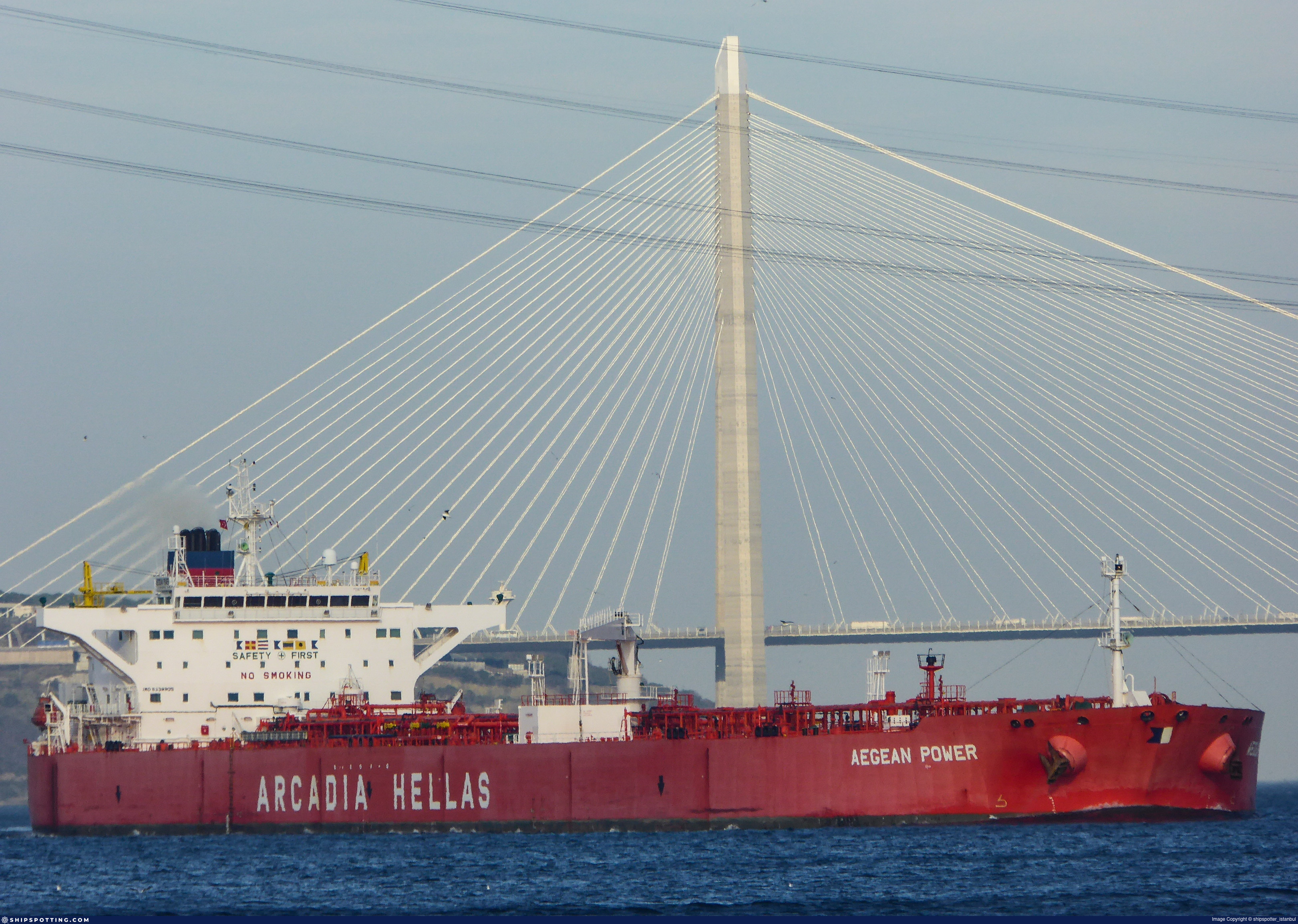
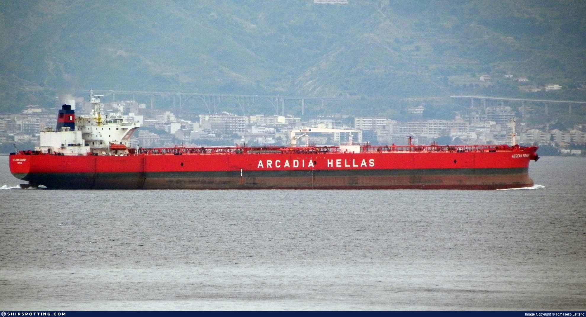
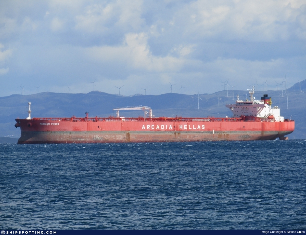
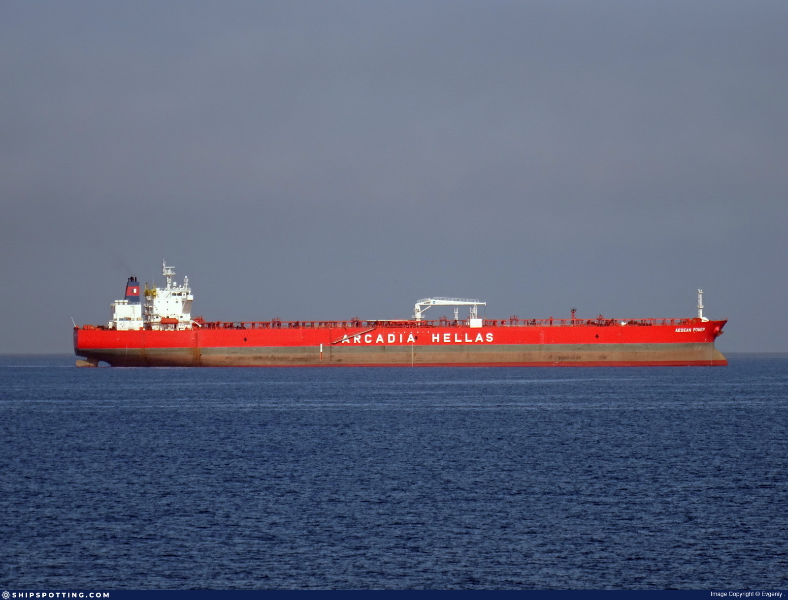
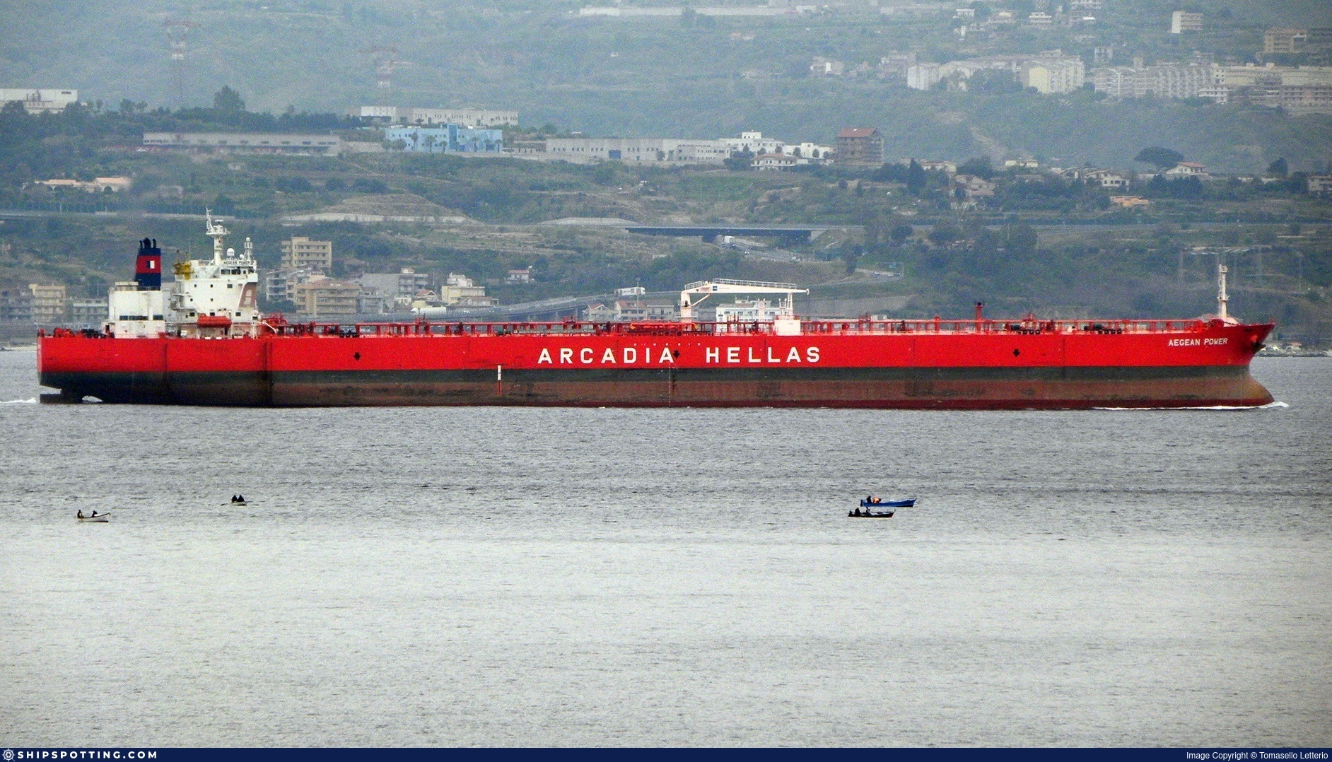
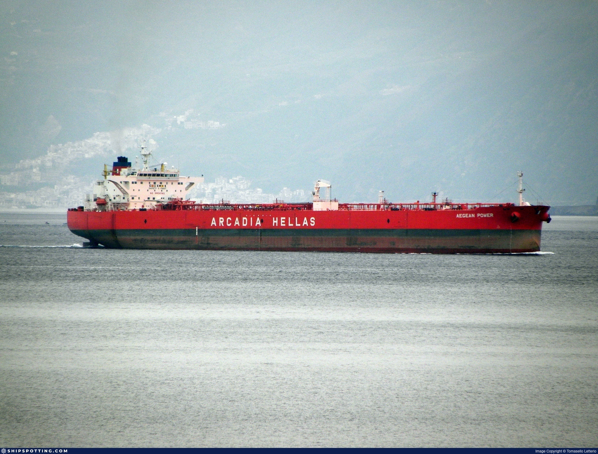
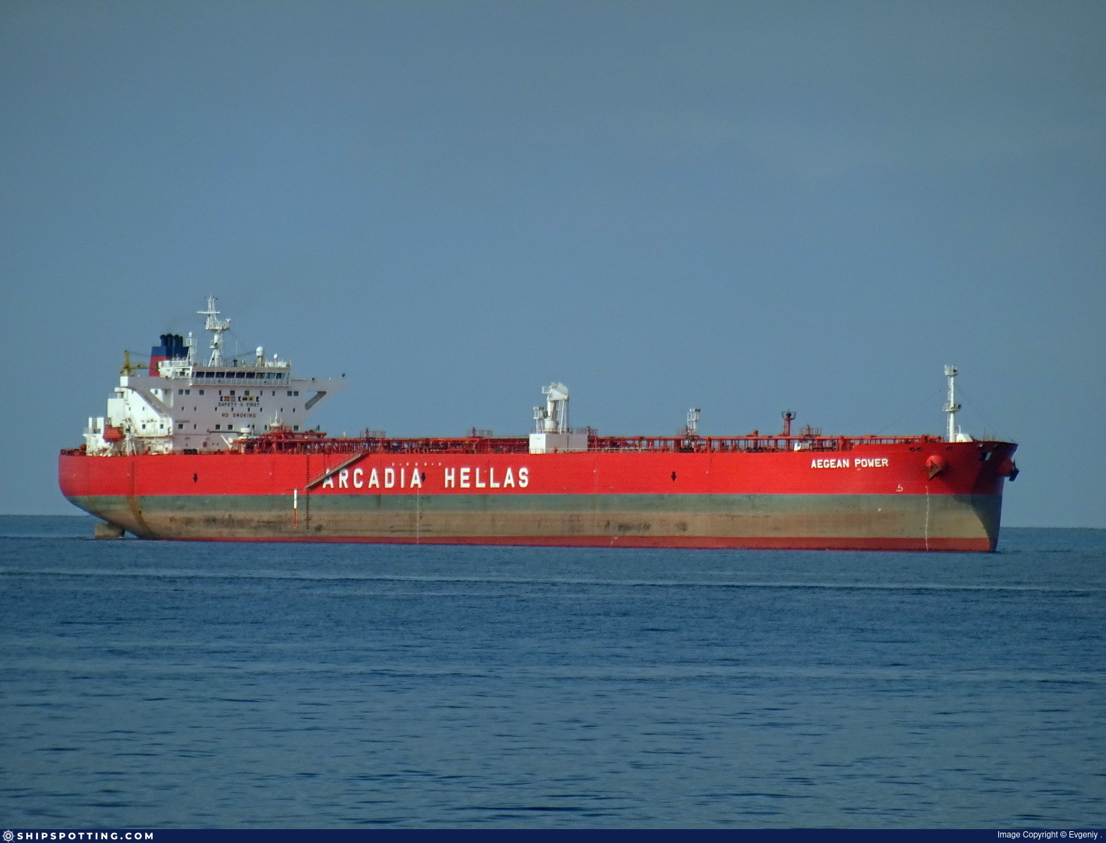
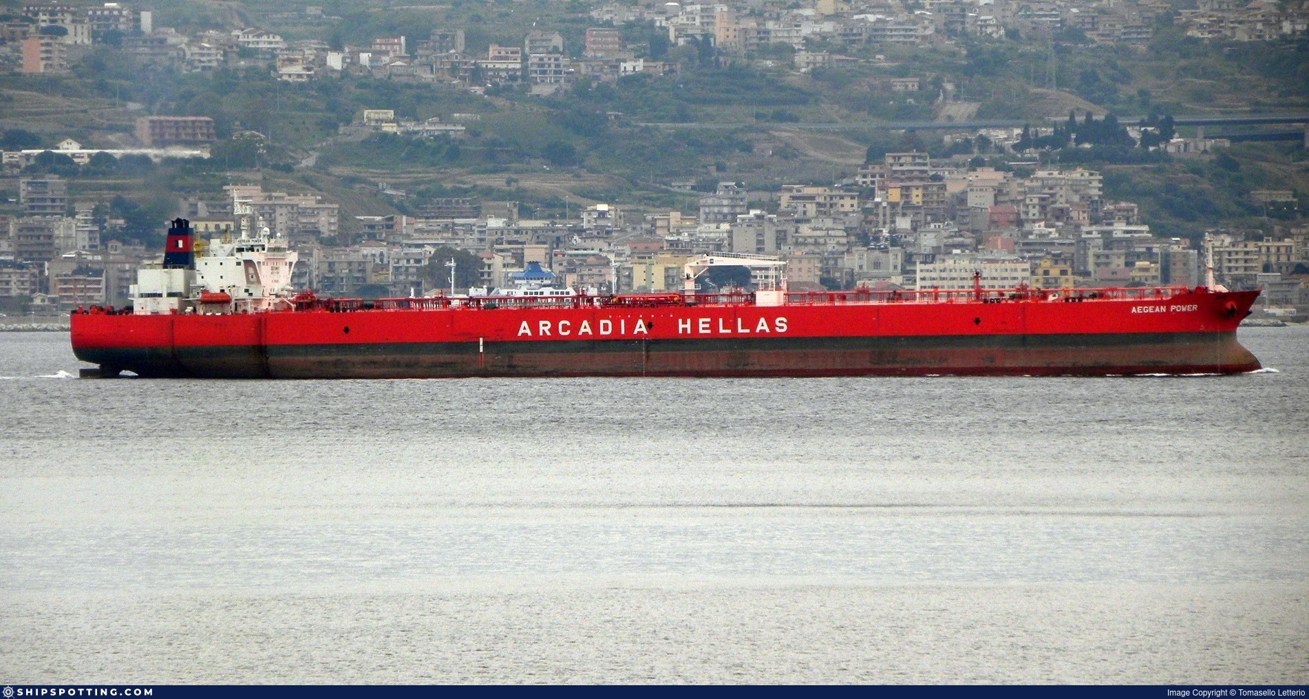
IMO 9338905
Vessel information
Sanctioned by
Company & Ownership
Management & Operations
Classification & Safety
Port State Control (PSC) Inspections
Survey Renewal & Certificates
| Code | Type | Issuer | Issued | Expires |
|---|---|---|---|---|
| 506 | International Air Pollution Prevention | DNV | 17/06/2022 | 04/05/2027 |
| 507 | International Sewage Pollution Prevention | DNV | 24/03/2022 | 04/05/2027 |
Programs & Notes
AU vessel designations (DFAT) | SEMA (Canada) — vessel designations | The Russia (Sanctions) (EU Exit) Regulations 2019 | Added in EU Sanctions Package 18 | (Council Decision (CFSP) 2025/1495, Annex XVI to Decision 2014/512/CFSP) | Press Release | Official Journal
DateOfListing: 2025-07-20 || DateDesignated: 2025-05-09 | Shipping sanctions: (see “Other information”) | Shipping sanctions: a specified ship is prohibited from being provided with access to or having its master or pilot cause it to enter a port in the UK, may have its registration on the UK Ship Register terminated, and a master or pilot of a specified ship may be given a port barring direction, a detention direction, and a port entry direction or a movement direction. | IMO 9338905 (“SHAANXI”) is involved in activity whose object or effect is to destabilise Ukraine or undermine or threaten the territorial integrity, sovereignty or independence of Ukraine or to obtain a benefit from or support the Government of Russia. Namely, SHAANXI is involved in carrying oil or oil products that originated in Russia from Russia to a third country.
Vessel Changes
 🔄 Owner
AIS Events
50 events detected • 3 zones • Last: Jul 16, 2026
- Zone: Baltic Sea Surveillance Zone
- Duration: 6h 27m
- Data Points: 3 AIS positions
- Period: 2026-07-16T22:29:46+00:00 to 2026-07-17T04:56:46+00:00
Show Raw Evidence JSON
{
    "zone_id": "discovered_015",
    "zone_name": "Baltic Sea Surveillance Zone",
    "dwell_minutes": 387,
    "points_in_zone": 3,
    "first_point": {
        "ts": "2026-07-16T22:29:46+00:00",
        "lat": 55.0230667000000011057636584155261516571044921875,
        "lon": 20.6056999999999987949195201508700847625732421875
    },
    "last_point": {
        "ts": "2026-07-17T04:56:46+00:00",
        "lat": 54.86378330000000147492755786515772342681884765625,
        "lon": 20.2645499999999998408384271897375583648681640625
    }
}- Gap Duration: 6h 26m
- Last Seen: 2026-07-16T22:29:46+00:00 at 55.0231, 20.6057 (Zone: Baltic Sea Surveillance Zone)
- Next Seen: 2026-07-17T04:55:46+00:00 at 54.8586, 20.2645
🛰️ Gap Corroboration
These are snapshots that may corroborate presence during the gap. They do not reconstruct a continuous route.
SAR Imagery (Sentinel-1)
Status: ✗ No SAR coverage
No Sentinel-1 scenes covering corridor and time window
VIIRS Thermal Anomaly
Status: ✗ No detections
No VIIRS thermal/light detections in corridor
Show Raw Evidence JSON
{
    "gap_minutes": 386,
    "last_seen": {
        "ts": "2026-07-16T22:29:46+00:00",
        "lat": 55.0230667000000011057636584155261516571044921875,
        "lon": 20.6056999999999987949195201508700847625732421875,
        "sog": 9.800000000000000710542735760100185871124267578125,
        "zone_id": "discovered_015"
    },
    "next_seen": {
        "ts": "2026-07-17T04:55:46+00:00",
        "lat": 54.85855000000000103455022326670587062835693359375,
        "lon": 20.264450000000000073896444519050419330596923828125,
        "zone_ids": [
            "discovered_015"
        ]
    },
    "gap_enrichment": {
        "status": "not_found",
        "corridor": {
            "start": {
                "lat": 55.0230667000000011057636584155261516571044921875,
                "lon": 20.6056999999999987949195201508700847625732421875,
                "ts": "2026-07-16T22:29:46+00:00"
            },
            "end": {
                "lat": 54.85855000000000103455022326670587062835693359375,
                "lon": 20.264450000000000073896444519050419330596923828125,
                "ts": "2026-07-17T04:55:46+00:00"
            },
            "bbox": {
                "min_lat": 54.678370000000001027729013003408908843994140625,
                "min_lon": 19.9507779999999996789483702741563320159912109375,
                "max_lat": 55.20324699999999751298673800192773342132568359375,
                "max_lon": 20.919371999999999189867594395764172077178955078125
            },
            "buffer_km": 20
        },
        "sar": {
            "status": "not_found",
            "notes": "No Sentinel-1 scenes covering corridor and time window"
        },
        "viirs": {
            "status": "not_found",
            "notes": "No VIIRS thermal\/light detections in corridor"
        },
        "searched_at": "2026-07-17T05:15:01.702478+00:00"
    }
}- Zone: Baltic Sea Surveillance Zone
- Duration: 1h 23m
- Data Points: 5 AIS positions
- Period: 2026-07-16T21:06:45+00:00 to 2026-07-16T22:29:46+00:00
Show Raw Evidence JSON
{
    "zone_id": "discovered_015",
    "zone_name": "Baltic Sea Surveillance Zone",
    "dwell_minutes": 83,
    "points_in_zone": 5,
    "first_point": {
        "ts": "2026-07-16T21:06:45+00:00",
        "lat": 55.29509999999999791953086969442665576934814453125,
        "lon": 20.39011670000000009395080269314348697662353515625
    },
    "last_point": {
        "ts": "2026-07-16T22:29:46+00:00",
        "lat": 55.0230667000000011057636584155261516571044921875,
        "lon": 20.6056999999999987949195201508700847625732421875
    }
}- Zone: Baltic Sea Surveillance Zone
- Duration: 2h 33m
- Data Points: 6 AIS positions
- Period: 2026-07-16T19:56:06+00:00 to 2026-07-16T22:29:46+00:00
Show Raw Evidence JSON
{
    "zone_id": "discovered_015",
    "zone_name": "Baltic Sea Surveillance Zone",
    "dwell_minutes": 153.69999999999998863131622783839702606201171875,
    "points_in_zone": 6,
    "first_point": {
        "ts": "2026-07-16T19:56:06+00:00",
        "lat": 54.8801332999999971207216731272637844085693359375,
        "lon": 20.040383299999998456542016356252133846282958984375
    },
    "last_point": {
        "ts": "2026-07-16T22:29:46+00:00",
        "lat": 55.0230667000000011057636584155261516571044921875,
        "lon": 20.6056999999999987949195201508700847625732421875
    }
}- Zone: Baltic Sea Surveillance Zone
- Duration: 4h 27m
- Data Points: 7 AIS positions
- Period: 2026-07-16T18:02:13+00:00 to 2026-07-16T22:29:46+00:00
Show Raw Evidence JSON
{
    "zone_id": "discovered_015",
    "zone_name": "Baltic Sea Surveillance Zone",
    "dwell_minutes": 267.6000000000000227373675443232059478759765625,
    "points_in_zone": 7,
    "first_point": {
        "ts": "2026-07-16T18:02:13+00:00",
        "lat": 55.34471669999999932088030618615448474884033203125,
        "lon": 20.35255000000000080717654782347381114959716796875
    },
    "last_point": {
        "ts": "2026-07-16T22:29:46+00:00",
        "lat": 55.0230667000000011057636584155261516571044921875,
        "lon": 20.6056999999999987949195201508700847625732421875
    }
}- Zone: Baltic Sea Surveillance Zone
- Duration: 5h 20m
- Data Points: 12 AIS positions
- Period: 2026-07-16T17:09:20+00:00 to 2026-07-16T22:29:46+00:00
Show Raw Evidence JSON
{
    "zone_id": "discovered_015",
    "zone_name": "Baltic Sea Surveillance Zone",
    "dwell_minutes": 320.3999999999999772626324556767940521240234375,
    "points_in_zone": 12,
    "first_point": {
        "ts": "2026-07-16T17:09:20+00:00",
        "lat": 55.34233329999999995152393239550292491912841796875,
        "lon": 20.35223330000000174777596839703619480133056640625
    },
    "last_point": {
        "ts": "2026-07-16T22:29:46+00:00",
        "lat": 55.0230667000000011057636584155261516571044921875,
        "lon": 20.6056999999999987949195201508700847625732421875
    }
}- Zone: Baltic Sea Surveillance Zone
- Duration: 6h 25m
- Data Points: 15 AIS positions
- Period: 2026-07-16T16:04:32+00:00 to 2026-07-16T22:29:46+00:00
Show Raw Evidence JSON
{
    "zone_id": "discovered_015",
    "zone_name": "Baltic Sea Surveillance Zone",
    "dwell_minutes": 385.19999999999998863131622783839702606201171875,
    "points_in_zone": 15,
    "first_point": {
        "ts": "2026-07-16T16:04:32+00:00",
        "lat": 55.05774999999999863575794734060764312744140625,
        "lon": 20.381466700000000713544068275950849056243896484375
    },
    "last_point": {
        "ts": "2026-07-16T22:29:46+00:00",
        "lat": 55.0230667000000011057636584155261516571044921875,
        "lon": 20.6056999999999987949195201508700847625732421875
    }
}- Zone: Baltic Sea Surveillance Zone
- Duration: 6h 34m
- Data Points: 16 AIS positions
- Period: 2026-07-16T15:55:22+00:00 to 2026-07-16T22:29:46+00:00
Show Raw Evidence JSON
{
    "zone_id": "discovered_015",
    "zone_name": "Baltic Sea Surveillance Zone",
    "dwell_minutes": 394.3999999999999772626324556767940521240234375,
    "points_in_zone": 16,
    "first_point": {
        "ts": "2026-07-16T15:55:22+00:00",
        "lat": 54.89193329999999804158505867235362529754638671875,
        "lon": 20.033666700000001270609573111869394779205322265625
    },
    "last_point": {
        "ts": "2026-07-16T22:29:46+00:00",
        "lat": 55.0230667000000011057636584155261516571044921875,
        "lon": 20.6056999999999987949195201508700847625732421875
    }
}- Zone: Baltic Sea Surveillance Zone
- Duration: 6h 34m
- Data Points: 16 AIS positions
- Period: 2026-07-16T14:33:41+00:00 to 2026-07-16T21:08:05+00:00
Show Raw Evidence JSON
{
    "zone_id": "discovered_015",
    "zone_name": "Baltic Sea Surveillance Zone",
    "dwell_minutes": 394.3999999999999772626324556767940521240234375,
    "points_in_zone": 16,
    "first_point": {
        "ts": "2026-07-16T14:33:41+00:00",
        "lat": 54.8820333000000033507603802718222141265869140625,
        "lon": 20.0406167000000010602889233268797397613525390625
    },
    "last_point": {
        "ts": "2026-07-16T21:08:05+00:00",
        "lat": 55.295850000000001500666257925331592559814453125,
        "lon": 20.384816699999998235171005944721400737762451171875
    }
}- Zone: Baltic Sea Surveillance Zone
- Duration: 6h 9m
- Data Points: 18 AIS positions
- Period: 2026-07-16T13:46:41+00:00 to 2026-07-16T19:56:06+00:00
Show Raw Evidence JSON
{
    "zone_id": "discovered_015",
    "zone_name": "Baltic Sea Surveillance Zone",
    "dwell_minutes": 369.3999999999999772626324556767940521240234375,
    "points_in_zone": 18,
    "first_point": {
        "ts": "2026-07-16T13:46:41+00:00",
        "lat": 55.055149999999997589839040301740169525146484375,
        "lon": 20.395966699999998894554664730094373226165771484375
    },
    "last_point": {
        "ts": "2026-07-16T19:56:06+00:00",
        "lat": 54.8801332999999971207216731272637844085693359375,
        "lon": 20.040383299999998456542016356252133846282958984375
    }
}- Zone: Baltic Sea Surveillance Zone
- Duration: 5h 59m
- Data Points: 21 AIS positions
- Period: 2026-07-16T12:02:38+00:00 to 2026-07-16T18:02:13+00:00
Show Raw Evidence JSON
{
    "zone_id": "discovered_015",
    "zone_name": "Baltic Sea Surveillance Zone",
    "dwell_minutes": 359.6000000000000227373675443232059478759765625,
    "points_in_zone": 21,
    "first_point": {
        "ts": "2026-07-16T12:02:38+00:00",
        "lat": 55.345016700000002174419932998716831207275390625,
        "lon": 20.347383300000000616591933066956698894500732421875
    },
    "last_point": {
        "ts": "2026-07-16T18:02:13+00:00",
        "lat": 55.34471669999999932088030618615448474884033203125,
        "lon": 20.35255000000000080717654782347381114959716796875
    }
}- Zone: Baltic Sea Surveillance Zone
- Duration: 6h 5m
- Data Points: 22 AIS positions
- Period: 2026-07-16T11:56:38+00:00 to 2026-07-16T18:02:13+00:00
Show Raw Evidence JSON
{
    "zone_id": "discovered_015",
    "zone_name": "Baltic Sea Surveillance Zone",
    "dwell_minutes": 365.6000000000000227373675443232059478759765625,
    "points_in_zone": 22,
    "first_point": {
        "ts": "2026-07-16T11:56:38+00:00",
        "lat": 55.3442332999999990761352819390594959259033203125,
        "lon": 20.348349999999999937472239253111183643341064453125
    },
    "last_point": {
        "ts": "2026-07-16T18:02:13+00:00",
        "lat": 55.34471669999999932088030618615448474884033203125,
        "lon": 20.35255000000000080717654782347381114959716796875
    }
}- Zone: Baltic Sea Surveillance Zone
- Duration: 6h 23m
- Data Points: 21 AIS positions
- Period: 2026-07-16T10:53:36+00:00 to 2026-07-16T17:17:14+00:00
Show Raw Evidence JSON
{
    "zone_id": "discovered_015",
    "zone_name": "Baltic Sea Surveillance Zone",
    "dwell_minutes": 383.6000000000000227373675443232059478759765625,
    "points_in_zone": 21,
    "first_point": {
        "ts": "2026-07-16T10:53:36+00:00",
        "lat": 55.34519999999999839701558812521398067474365234375,
        "lon": 20.350366699999998587600202881731092929840087890625
    },
    "last_point": {
        "ts": "2026-07-16T17:17:14+00:00",
        "lat": 55.3433332999999976209437591023743152618408203125,
        "lon": 20.351949999999998652810972998850047588348388671875
    }
}- Duration: 3h 22m
- Radius: 951 meters
- Data Points: 14 AIS positions
- Centroid: 55.3434, 20.3499
- Zone: Baltic Sea Surveillance Zone
Show Raw Evidence JSON
{
    "radius_m": 950.5,
    "duration_minutes": 202.900000000000005684341886080801486968994140625,
    "points": 14,
    "centroid": {
        "lat": 55.3433702357142891514740767888724803924560546875,
        "lon": 20.349930949999997409349816734902560710906982421875
    },
    "bbox": {
        "min_lat": 55.33486669999999918445610092021524906158447265625,
        "min_lon": 20.347100000000001074340616469271481037139892578125,
        "max_lat": 55.3458667000000019697836250998079776763916015625,
        "max_lon": 20.353533299999998718021743115969002246856689453125
    },
    "zone_id": "discovered_015"
}- Zone: Baltic Sea Surveillance Zone
- Duration: 6h 29m
- Data Points: 21 AIS positions
- Period: 2026-07-16T09:44:38+00:00 to 2026-07-16T16:14:34+00:00
Show Raw Evidence JSON
{
    "zone_id": "discovered_015",
    "zone_name": "Baltic Sea Surveillance Zone",
    "dwell_minutes": 389.8999999999999772626324556767940521240234375,
    "points_in_zone": 21,
    "first_point": {
        "ts": "2026-07-16T09:44:38+00:00",
        "lat": 55.3428499999999985448084771633148193359375,
        "lon": 20.35170000000000101181285572238266468048095703125
    },
    "last_point": {
        "ts": "2026-07-16T16:14:34+00:00",
        "lat": 54.8960000000000007958078640513122081756591796875,
        "lon": 20.026416699999998627390596084296703338623046875
    }
}- Duration: 4h 34m
- Radius: 1,007 meters
- Data Points: 22 AIS positions
- Centroid: 55.3439, 20.3502
- Zone: Baltic Sea Surveillance Zone
Show Raw Evidence JSON
{
    "radius_m": 1006.8999999999999772626324556767940521240234375,
    "duration_minutes": 274.6000000000000227373675443232059478759765625,
    "points": 22,
    "centroid": {
        "lat": 55.34389090454545367947503109462559223175048828125,
        "lon": 20.350206059090904631148077896796166896820068359375
    },
    "bbox": {
        "min_lat": 55.33486669999999918445610092021524906158447265625,
        "min_lon": 20.347100000000001074340616469271481037139892578125,
        "max_lat": 55.348933299999998780549503862857818603515625,
        "max_lon": 20.353533299999998718021743115969002246856689453125
    },
    "zone_id": "discovered_015"
}- Zone: Baltic Sea Surveillance Zone
- Duration: 6h 30m
- Data Points: 24 AIS positions
- Period: 2026-07-16T08:31:35+00:00 to 2026-07-16T15:01:42+00:00
Show Raw Evidence JSON
{
    "zone_id": "discovered_015",
    "zone_name": "Baltic Sea Surveillance Zone",
    "dwell_minutes": 390.1000000000000227373675443232059478759765625,
    "points_in_zone": 24,
    "first_point": {
        "ts": "2026-07-16T08:31:35+00:00",
        "lat": 55.3449166999999988547642715275287628173828125,
        "lon": 20.349283299999999741203282610513269901275634765625
    },
    "last_point": {
        "ts": "2026-07-16T15:01:42+00:00",
        "lat": 55.34368330000000213431121665053069591522216796875,
        "lon": 20.351800000000000778754838393069803714752197265625
    }
}- Duration: 5h 22m
- Radius: 1,010 meters
- Data Points: 24 AIS positions
- Centroid: 55.3439, 20.3503
- Zone: Baltic Sea Surveillance Zone
Show Raw Evidence JSON
{
    "radius_m": 1009.700000000000045474735088646411895751953125,
    "duration_minutes": 322.6000000000000227373675443232059478759765625,
    "points": 24,
    "centroid": {
        "lat": 55.34391874583334214321439503692090511322021484375,
        "lon": 20.350279166666663144269477925263345241546630859375
    },
    "bbox": {
        "min_lat": 55.33486669999999918445610092021524906158447265625,
        "min_lon": 20.347100000000001074340616469271481037139892578125,
        "max_lat": 55.348933299999998780549503862857818603515625,
        "max_lon": 20.353533299999998718021743115969002246856689453125
    },
    "zone_id": "discovered_015"
}- Zone: Baltic Sea Surveillance Zone
- Duration: 6h 34m
- Data Points: 26 AIS positions
- Period: 2026-07-16T07:40:34+00:00 to 2026-07-16T14:15:30+00:00
Show Raw Evidence JSON
{
    "zone_id": "discovered_015",
    "zone_name": "Baltic Sea Surveillance Zone",
    "dwell_minutes": 394.8999999999999772626324556767940521240234375,
    "points_in_zone": 26,
    "first_point": {
        "ts": "2026-07-16T07:40:34+00:00",
        "lat": 55.3447000000000031150193535722792148590087890625,
        "lon": 20.351400000000001710986907710321247577667236328125
    },
    "last_point": {
        "ts": "2026-07-16T14:15:30+00:00",
        "lat": 54.87904999999999944293449516408145427703857421875,
        "lon": 20.039583300000000321006154990755021572113037109375
    }
}- Duration: 6h 1m
- Radius: 1,015 meters
- Data Points: 28 AIS positions
- Centroid: 55.3440, 20.3503
- Zone: Baltic Sea Surveillance Zone
Show Raw Evidence JSON
{
    "radius_m": 1014.6000000000000227373675443232059478759765625,
    "duration_minutes": 361.19999999999998863131622783839702606201171875,
    "points": 28,
    "centroid": {
        "lat": 55.34396368571430002702982164919376373291015625,
        "lon": 20.350308332142855505253464798443019390106201171875
    },
    "bbox": {
        "min_lat": 55.33486669999999918445610092021524906158447265625,
        "min_lon": 20.347100000000001074340616469271481037139892578125,
        "max_lat": 55.348933299999998780549503862857818603515625,
        "max_lon": 20.353533299999998718021743115969002246856689453125
    },
    "zone_id": "discovered_015"
}- Zone: Baltic Sea Surveillance Zone
- Duration: 6h 8m
- Data Points: 29 AIS positions
- Period: 2026-07-16T06:27:18+00:00 to 2026-07-16T12:36:08+00:00
Show Raw Evidence JSON
{
    "zone_id": "discovered_015",
    "zone_name": "Baltic Sea Surveillance Zone",
    "dwell_minutes": 368.80000000000001136868377216160297393798828125,
    "points_in_zone": 29,
    "first_point": {
        "ts": "2026-07-16T06:27:18+00:00",
        "lat": 55.0253000000000014324541552923619747161865234375,
        "lon": 20.606533299999998831708580837585031986236572265625
    },
    "last_point": {
        "ts": "2026-07-16T12:36:08+00:00",
        "lat": 55.33486669999999918445610092021524906158447265625,
        "lon": 20.351266700000000042791725718416273593902587890625
    }
}- Zone: Baltic Sea Surveillance Zone
- Duration: 6h 31m
- Data Points: 24 AIS positions
- Period: 2026-07-16T04:03:48+00:00 to 2026-07-16T10:35:36+00:00
Show Raw Evidence JSON
{
    "zone_id": "discovered_015",
    "zone_name": "Baltic Sea Surveillance Zone",
    "dwell_minutes": 391.80000000000001136868377216160297393798828125,
    "points_in_zone": 24,
    "first_point": {
        "ts": "2026-07-16T04:03:48+00:00",
        "lat": 54.85666669999999811579982633702456951141357421875,
        "lon": 20.29308329999999926940290606580674648284912109375
    },
    "last_point": {
        "ts": "2026-07-16T10:35:36+00:00",
        "lat": 55.3434333000000009405994205735623836517333984375,
        "lon": 20.35119999999999862438926356844604015350341796875
    }
}- Zone: Baltic Sea Surveillance Zone
- Duration: 6h 19m
- Data Points: 15 AIS positions
- Period: 2026-07-16T01:59:49+00:00 to 2026-07-16T08:19:34+00:00
Show Raw Evidence JSON
{
    "zone_id": "discovered_015",
    "zone_name": "Baltic Sea Surveillance Zone",
    "dwell_minutes": 379.80000000000001136868377216160297393798828125,
    "points_in_zone": 15,
    "first_point": {
        "ts": "2026-07-16T01:59:49+00:00",
        "lat": 54.865133299999996552287484519183635711669921875,
        "lon": 20.26435000000000030695446184836328029632568359375
    },
    "last_point": {
        "ts": "2026-07-16T08:19:34+00:00",
        "lat": 55.34426669999999859328454476781189441680908203125,
        "lon": 20.3509999999999990905052982270717620849609375
    }
}- Zone: Baltic Sea Surveillance Zone
- Duration: 6h 37m
- Data Points: 5 AIS positions
- Period: 2026-07-15T19:22:15+00:00 to 2026-07-16T01:59:49+00:00
Show Raw Evidence JSON
{
    "zone_id": "discovered_015",
    "zone_name": "Baltic Sea Surveillance Zone",
    "dwell_minutes": 397.6000000000000227373675443232059478759765625,
    "points_in_zone": 5,
    "first_point": {
        "ts": "2026-07-15T19:22:15+00:00",
        "lat": 55.34286670000000185609678737819194793701171875,
        "lon": 20.350698300000001239595803781412541866302490234375
    },
    "last_point": {
        "ts": "2026-07-16T01:59:49+00:00",
        "lat": 54.865133299999996552287484519183635711669921875,
        "lon": 20.26435000000000030695446184836328029632568359375
    }
}- Zone: Baltic Sea Surveillance Zone
- Duration: 1h 14m
- Data Points: 9 AIS positions
- Period: 2026-07-15T18:19:55+00:00 to 2026-07-15T19:33:57+00:00
Show Raw Evidence JSON
{
    "zone_id": "discovered_015",
    "zone_name": "Baltic Sea Surveillance Zone",
    "dwell_minutes": 74,
    "points_in_zone": 9,
    "first_point": {
        "ts": "2026-07-15T18:19:55+00:00",
        "lat": 55.3429000000000002046363078989088535308837890625,
        "lon": 20.3518499999999988858689903281629085540771484375
    },
    "last_point": {
        "ts": "2026-07-15T19:33:57+00:00",
        "lat": 55.3427999999999968849806464277207851409912109375,
        "lon": 20.350699999999999789679350215010344982147216796875
    }
}- Duration: 2h 28m
- Radius: 59 meters
- Data Points: 14 AIS positions
- Centroid: 55.3428, 20.3513
- Zone: Baltic Sea Surveillance Zone
Show Raw Evidence JSON
{
    "radius_m": 58.89999999999999857891452847979962825775146484375,
    "duration_minutes": 148.5,
    "points": 14,
    "centroid": {
        "lat": 55.34284893571429364556024665944278240203857421875,
        "lon": 20.351263678571431370301070273853838443756103515625
    },
    "bbox": {
        "min_lat": 55.342631699999998318162397481501102447509765625,
        "min_lon": 20.350698300000001239595803781412541866302490234375,
        "max_lat": 55.3432667000000009238647180609405040740966796875,
        "max_lon": 20.3518499999999988858689903281629085540771484375
    },
    "zone_id": "discovered_015"
}- Zone: Baltic Sea Surveillance Zone
- Duration: 2h 28m
- Data Points: 14 AIS positions
- Period: 2026-07-15T17:05:25+00:00 to 2026-07-15T19:33:57+00:00
Show Raw Evidence JSON
{
    "zone_id": "discovered_015",
    "zone_name": "Baltic Sea Surveillance Zone",
    "dwell_minutes": 148.5,
    "points_in_zone": 14,
    "first_point": {
        "ts": "2026-07-15T17:05:25+00:00",
        "lat": 55.342631699999998318162397481501102447509765625,
        "lon": 20.351793300000000641603037365712225437164306640625
    },
    "last_point": {
        "ts": "2026-07-15T19:33:57+00:00",
        "lat": 55.3427999999999968849806464277207851409912109375,
        "lon": 20.350699999999999789679350215010344982147216796875
    }
}- Duration: 3h 17m
- Radius: 58 meters
- Data Points: 16 AIS positions
- Centroid: 55.3428, 20.3513
- Zone: Baltic Sea Surveillance Zone
Show Raw Evidence JSON
{
    "radius_m": 57.7000000000000028421709430404007434844970703125,
    "duration_minutes": 197.19999999999998863131622783839702606201171875,
    "points": 16,
    "centroid": {
        "lat": 55.34283344375000268655639956705272197723388671875,
        "lon": 20.351334887499998416160451597534120082855224609375
    },
    "bbox": {
        "min_lat": 55.342631699999998318162397481501102447509765625,
        "min_lon": 20.350698300000001239595803781412541866302490234375,
        "max_lat": 55.3432667000000009238647180609405040740966796875,
        "max_lon": 20.351866699999998644443621742539107799530029296875
    },
    "zone_id": "discovered_015"
}- Zone: Baltic Sea Surveillance Zone
- Duration: 3h 17m
- Data Points: 16 AIS positions
- Period: 2026-07-15T16:16:43+00:00 to 2026-07-15T19:33:57+00:00
Show Raw Evidence JSON
{
    "zone_id": "discovered_015",
    "zone_name": "Baltic Sea Surveillance Zone",
    "dwell_minutes": 197.19999999999998863131622783839702606201171875,
    "points_in_zone": 16,
    "first_point": {
        "ts": "2026-07-15T16:16:43+00:00",
        "lat": 55.3427166999999968766132951714098453521728515625,
        "lon": 20.351800000000000778754838393069803714752197265625
    },
    "last_point": {
        "ts": "2026-07-15T19:33:57+00:00",
        "lat": 55.3427999999999968849806464277207851409912109375,
        "lon": 20.350699999999999789679350215010344982147216796875
    }
}- Zone: Baltic Sea Surveillance Zone
- Duration: 4h 23m
- Data Points: 21 AIS positions
- Period: 2026-07-15T15:10:10+00:00 to 2026-07-15T19:33:57+00:00
Show Raw Evidence JSON
{
    "zone_id": "discovered_015",
    "zone_name": "Baltic Sea Surveillance Zone",
    "dwell_minutes": 263.80000000000001136868377216160297393798828125,
    "points_in_zone": 21,
    "first_point": {
        "ts": "2026-07-15T15:10:10+00:00",
        "lat": 55.34278330000000067911969381384551525115966796875,
        "lon": 20.352283299999999854890120332129299640655517578125
    },
    "last_point": {
        "ts": "2026-07-15T19:33:57+00:00",
        "lat": 55.3427999999999968849806464277207851409912109375,
        "lon": 20.350699999999999789679350215010344982147216796875
    }
}- Duration: 4h 23m
- Radius: 54 meters
- Data Points: 21 AIS positions
- Centroid: 55.3428, 20.3515
- Zone: Baltic Sea Surveillance Zone
Show Raw Evidence JSON
{
    "radius_m": 53.89999999999999857891452847979962825775146484375,
    "duration_minutes": 263.80000000000001136868377216160297393798828125,
    "points": 21,
    "centroid": {
        "lat": 55.34281754285715493324460112489759922027587890625,
        "lon": 20.351517057142853417417427408508956432342529296875
    },
    "bbox": {
        "min_lat": 55.342631699999998318162397481501102447509765625,
        "min_lon": 20.350698300000001239595803781412541866302490234375,
        "max_lat": 55.3432667000000009238647180609405040740966796875,
        "max_lon": 20.352283299999999854890120332129299640655517578125
    },
    "zone_id": "discovered_015"
}- Zone: Baltic Sea Surveillance Zone
- Duration: 5h 28m
- Data Points: 26 AIS positions
- Period: 2026-07-15T14:05:42+00:00 to 2026-07-15T19:33:57+00:00
Show Raw Evidence JSON
{
    "zone_id": "discovered_015",
    "zone_name": "Baltic Sea Surveillance Zone",
    "dwell_minutes": 328.19999999999998863131622783839702606201171875,
    "points_in_zone": 26,
    "first_point": {
        "ts": "2026-07-15T14:05:42+00:00",
        "lat": 55.3427166999999968766132951714098453521728515625,
        "lon": 20.351983300000000554064172320067882537841796875
    },
    "last_point": {
        "ts": "2026-07-15T19:33:57+00:00",
        "lat": 55.3427999999999968849806464277207851409912109375,
        "lon": 20.350699999999999789679350215010344982147216796875
    }
}- Zone: Baltic Sea Surveillance Zone
- Duration: 6h 18m
- Data Points: 28 AIS positions
- Period: 2026-07-15T13:15:21+00:00 to 2026-07-15T19:33:57+00:00
Show Raw Evidence JSON
{
    "zone_id": "discovered_015",
    "zone_name": "Baltic Sea Surveillance Zone",
    "dwell_minutes": 378.6000000000000227373675443232059478759765625,
    "points_in_zone": 28,
    "first_point": {
        "ts": "2026-07-15T13:15:21+00:00",
        "lat": 55.049025000000000318323145620524883270263671875,
        "lon": 20.393106700000000586214810027740895748138427734375
    },
    "last_point": {
        "ts": "2026-07-15T19:33:57+00:00",
        "lat": 55.3427999999999968849806464277207851409912109375,
        "lon": 20.350699999999999789679350215010344982147216796875
    }
}- Zone: Baltic Sea Surveillance Zone
- Duration: 6h 30m
- Data Points: 28 AIS positions
- Period: 2026-07-15T12:57:32+00:00 to 2026-07-15T19:27:59+00:00
Show Raw Evidence JSON
{
    "zone_id": "discovered_015",
    "zone_name": "Baltic Sea Surveillance Zone",
    "dwell_minutes": 390.3999999999999772626324556767940521240234375,
    "points_in_zone": 28,
    "first_point": {
        "ts": "2026-07-15T12:57:32+00:00",
        "lat": 55.05018499999999903593561612069606781005859375,
        "lon": 20.392816700000000906811692402698099613189697265625
    },
    "last_point": {
        "ts": "2026-07-15T19:27:59+00:00",
        "lat": 55.3428499999999985448084771633148193359375,
        "lon": 20.350816699999999315195964300073683261871337890625
    }
}- Zone: Baltic Sea Surveillance Zone
- Duration: 6h 33m
- Data Points: 26 AIS positions
- Period: 2026-07-15T11:46:11+00:00 to 2026-07-15T18:19:55+00:00
Show Raw Evidence JSON
{
    "zone_id": "discovered_015",
    "zone_name": "Baltic Sea Surveillance Zone",
    "dwell_minutes": 393.69999999999998863131622783839702606201171875,
    "points_in_zone": 26,
    "first_point": {
        "ts": "2026-07-15T11:46:11+00:00",
        "lat": 54.88287669999999707215465605258941650390625,
        "lon": 20.040491700000000463433025288395583629608154296875
    },
    "last_point": {
        "ts": "2026-07-15T18:19:55+00:00",
        "lat": 55.3429000000000002046363078989088535308837890625,
        "lon": 20.3518499999999988858689903281629085540771484375
    }
}- Zone: Baltic Sea Surveillance Zone
- Duration: 6h 26m
- Data Points: 16 AIS positions
- Period: 2026-07-15T08:27:43+00:00 to 2026-07-15T14:54:30+00:00
Show Raw Evidence JSON
{
    "zone_id": "discovered_015",
    "zone_name": "Baltic Sea Surveillance Zone",
    "dwell_minutes": 386.80000000000001136868377216160297393798828125,
    "points_in_zone": 16,
    "first_point": {
        "ts": "2026-07-15T08:27:43+00:00",
        "lat": 55.3427999999999968849806464277207851409912109375,
        "lon": 20.351350000000000051159076974727213382720947265625
    },
    "last_point": {
        "ts": "2026-07-15T14:54:30+00:00",
        "lat": 54.8740499999999968849806464277207851409912109375,
        "lon": 20.046216699999998667180989286862313747406005859375
    }
}- Zone: Baltic Sea Surveillance Zone
- Duration: 2h 50m
- Data Points: 2 AIS positions
- Period: 2026-07-14T16:19:22+00:00 to 2026-07-14T19:09:46+00:00
Show Raw Evidence JSON
{
    "zone_id": "discovered_015",
    "zone_name": "Baltic Sea Surveillance Zone",
    "dwell_minutes": 170.400000000000005684341886080801486968994140625,
    "points_in_zone": 2,
    "first_point": {
        "ts": "2026-07-14T16:19:22+00:00",
        "lat": 55.34440000000000026147972675971686840057373046875,
        "lon": 20.354183299999998979501469875685870647430419921875
    },
    "last_point": {
        "ts": "2026-07-14T19:09:46+00:00",
        "lat": 55.350466699999998354542185552418231964111328125,
        "lon": 20.356983299999999559304342255927622318267822265625
    }
}- Zone: Baltic Sea Surveillance Zone
- Duration: 3h 42m
- Data Points: 4 AIS positions
- Period: 2026-07-14T15:27:45+00:00 to 2026-07-14T19:09:46+00:00
Show Raw Evidence JSON
{
    "zone_id": "discovered_015",
    "zone_name": "Baltic Sea Surveillance Zone",
    "dwell_minutes": 222,
    "points_in_zone": 4,
    "first_point": {
        "ts": "2026-07-14T15:27:45+00:00",
        "lat": 55.34759999999999990905052982270717620849609375,
        "lon": 20.352516699999998905923348502255976200103759765625
    },
    "last_point": {
        "ts": "2026-07-14T19:09:46+00:00",
        "lat": 55.350466699999998354542185552418231964111328125,
        "lon": 20.356983299999999559304342255927622318267822265625
    }
}- Zone: Baltic Sea Surveillance Zone
- Duration: 2h 27m
- Data Points: 4 AIS positions
- Period: 2026-07-11T09:06:37+00:00 to 2026-07-11T11:33:37+00:00
Show Raw Evidence JSON
{
    "zone_id": "discovered_015",
    "zone_name": "Baltic Sea Surveillance Zone",
    "dwell_minutes": 147,
    "points_in_zone": 4,
    "first_point": {
        "ts": "2026-07-11T09:06:37+00:00",
        "lat": 55.3201499999999981582732289098203182220458984375,
        "lon": 20.2644666999999998324710759334266185760498046875
    },
    "last_point": {
        "ts": "2026-07-11T11:33:37+00:00",
        "lat": 55.3206167000000021971573005430400371551513671875,
        "lon": 20.265350000000001529087967355735599994659423828125
    }
}- Zone: Archipelago Sea Monitoring Zone
- Duration: 1h 7m
- Data Points: 20 AIS positions
- Period: 2026-07-03T02:16:49+00:00 to 2026-07-03T03:24:09+00:00
Show Raw Evidence JSON
{
    "zone_id": "discovered_008",
    "zone_name": "Archipelago Sea Monitoring Zone",
    "dwell_minutes": 67.2999999999999971578290569595992565155029296875,
    "points_in_zone": 20,
    "first_point": {
        "ts": "2026-07-03T02:16:49+00:00",
        "lat": 59.4256333000000012134478311054408550262451171875,
        "lon": 22.299700000000001409716787748038768768310546875
    },
    "last_point": {
        "ts": "2026-07-03T03:24:09+00:00",
        "lat": 59.308549999999996771293808706104755401611328125,
        "lon": 22.00146670000000170830389834009110927581787109375
    }
}- Zone: Archipelago Sea Monitoring Zone
- Duration: 2h 24m
- Data Points: 33 AIS positions
- Period: 2026-07-03T01:00:09+00:00 to 2026-07-03T03:24:09+00:00
Show Raw Evidence JSON
{
    "zone_id": "discovered_008",
    "zone_name": "Archipelago Sea Monitoring Zone",
    "dwell_minutes": 144,
    "points_in_zone": 33,
    "first_point": {
        "ts": "2026-07-03T01:00:09+00:00",
        "lat": 59.54028329999999868960003368556499481201171875,
        "lon": 22.66666670000000038953658076934516429901123046875
    },
    "last_point": {
        "ts": "2026-07-03T03:24:09+00:00",
        "lat": 59.308549999999996771293808706104755401611328125,
        "lon": 22.00146670000000170830389834009110927581787109375
    }
}- Zone: Archipelago Sea Monitoring Zone
- Duration: 3h 22m
- Data Points: 60 AIS positions
- Period: 2026-07-03T00:01:19+00:00 to 2026-07-03T03:24:09+00:00
Show Raw Evidence JSON
{
    "zone_id": "discovered_008",
    "zone_name": "Archipelago Sea Monitoring Zone",
    "dwell_minutes": 202.80000000000001136868377216160297393798828125,
    "points_in_zone": 60,
    "first_point": {
        "ts": "2026-07-03T00:01:19+00:00",
        "lat": 59.594566700000001446824171580374240875244140625,
        "lon": 22.994450000000000500222085975110530853271484375
    },
    "last_point": {
        "ts": "2026-07-03T03:24:09+00:00",
        "lat": 59.308549999999996771293808706104755401611328125,
        "lon": 22.00146670000000170830389834009110927581787109375
    }
}- Zone: Archipelago Sea Monitoring Zone
- Duration: 4h 24m
- Data Points: 82 AIS positions
- Period: 2026-07-02T23:00:08+00:00 to 2026-07-03T03:24:09+00:00
Show Raw Evidence JSON
{
    "zone_id": "discovered_008",
    "zone_name": "Archipelago Sea Monitoring Zone",
    "dwell_minutes": 264,
    "points_in_zone": 82,
    "first_point": {
        "ts": "2026-07-02T23:00:08+00:00",
        "lat": 59.640033299999998916973709128797054290771484375,
        "lon": 23.341300000000000380850906367413699626922607421875
    },
    "last_point": {
        "ts": "2026-07-03T03:24:09+00:00",
        "lat": 59.308549999999996771293808706104755401611328125,
        "lon": 22.00146670000000170830389834009110927581787109375
    }
}- Zone: Archipelago Sea Monitoring Zone
- Duration: 5h 1m
- Data Points: 97 AIS positions
- Period: 2026-07-02T22:22:18+00:00 to 2026-07-03T03:24:09+00:00
Show Raw Evidence JSON
{
    "zone_id": "discovered_008",
    "zone_name": "Archipelago Sea Monitoring Zone",
    "dwell_minutes": 301.8999999999999772626324556767940521240234375,
    "points_in_zone": 97,
    "first_point": {
        "ts": "2026-07-02T22:22:18+00:00",
        "lat": 59.6669499999999999317878973670303821563720703125,
        "lon": 23.55576669999999950277924654074013233184814453125
    },
    "last_point": {
        "ts": "2026-07-03T03:24:09+00:00",
        "lat": 59.308549999999996771293808706104755401611328125,
        "lon": 22.00146670000000170830389834009110927581787109375
    }
}- Zone: Baltic Exit/Tallinn Approach
- Duration: 1h 34m
- Data Points: 34 AIS positions
- Period: 2026-07-02T17:00:09+00:00 to 2026-07-02T18:34:19+00:00
Show Raw Evidence JSON
{
    "zone_id": "russia_baltic_transit",
    "zone_name": "Baltic Exit\/Tallinn Approach",
    "dwell_minutes": 94.2000000000000028421709430404007434844970703125,
    "points_in_zone": 34,
    "first_point": {
        "ts": "2026-07-02T17:00:09+00:00",
        "lat": 59.87296669999999920719346846453845500946044921875,
        "lon": 25.359049999999999869260136620141565799713134765625
    },
    "last_point": {
        "ts": "2026-07-02T18:34:19+00:00",
        "lat": 59.83935000000000314912540488876402378082275390625,
        "lon": 24.81315000000000026147972675971686840057373046875
    }
}- Zone: Baltic Exit/Tallinn Approach
- Duration: 2h 32m
- Data Points: 56 AIS positions
- Period: 2026-07-02T16:02:19+00:00 to 2026-07-02T18:34:19+00:00
Show Raw Evidence JSON
{
    "zone_id": "russia_baltic_transit",
    "zone_name": "Baltic Exit\/Tallinn Approach",
    "dwell_minutes": 152,
    "points_in_zone": 56,
    "first_point": {
        "ts": "2026-07-02T16:02:19+00:00",
        "lat": 59.84270000000000067075234255753457546234130859375,
        "lon": 25.69038330000000058817022363655269145965576171875
    },
    "last_point": {
        "ts": "2026-07-02T18:34:19+00:00",
        "lat": 59.83935000000000314912540488876402378082275390625,
        "lon": 24.81315000000000026147972675971686840057373046875
    }
}- Zone: Baltic Exit/Tallinn Approach
- Duration: 3h 7m
- Data Points: 65 AIS positions
- Period: 2026-07-02T15:26:47+00:00 to 2026-07-02T18:34:19+00:00
Show Raw Evidence JSON
{
    "zone_id": "russia_baltic_transit",
    "zone_name": "Baltic Exit\/Tallinn Approach",
    "dwell_minutes": 187.5,
    "points_in_zone": 65,
    "first_point": {
        "ts": "2026-07-02T15:26:47+00:00",
        "lat": 59.85053330000000215704858419485390186309814453125,
        "lon": 25.836483300000001150920070358552038669586181640625
    },
    "last_point": {
        "ts": "2026-07-02T18:34:19+00:00",
        "lat": 59.83935000000000314912540488876402378082275390625,
        "lon": 24.81315000000000026147972675971686840057373046875
    }
}- Zone: Baltic Exit/Tallinn Approach
- Duration: 4h 28m
- Data Points: 71 AIS positions
- Period: 2026-07-02T14:05:49+00:00 to 2026-07-02T18:34:19+00:00
Show Raw Evidence JSON
{
    "zone_id": "russia_baltic_transit",
    "zone_name": "Baltic Exit\/Tallinn Approach",
    "dwell_minutes": 268.5,
    "points_in_zone": 71,
    "first_point": {
        "ts": "2026-07-02T14:05:49+00:00",
        "lat": 59.84923330000000163408913067542016506195068359375,
        "lon": 25.836016699999998280645741033367812633514404296875
    },
    "last_point": {
        "ts": "2026-07-02T18:34:19+00:00",
        "lat": 59.83935000000000314912540488876402378082275390625,
        "lon": 24.81315000000000026147972675971686840057373046875
    }
}- Duration: 2h 27m
- Radius: 851 meters
- Data Points: 16 AIS positions
- Centroid: 59.8496, 25.8342
- Zone: Baltic Exit/Tallinn Approach
Show Raw Evidence JSON
{
    "radius_m": 851,
    "duration_minutes": 147.30000000000001136868377216160297393798828125,
    "points": 16,
    "centroid": {
        "lat": 59.84963435625000016671037883497774600982666015625,
        "lon": 25.8341552062500028341673896647989749908447265625
    },
    "bbox": {
        "min_lat": 59.849033300000002100205165334045886993408203125,
        "min_lon": 25.819383299999998371276888065040111541748046875,
        "max_lat": 59.85161670000000100344550446607172489166259765625,
        "max_lon": 25.836483300000001150920070358552038669586181640625
    },
    "zone_id": "russia_baltic_transit"
}- Zone: Baltic Exit/Tallinn Approach
- Duration: 5h 25m
- Data Points: 78 AIS positions
- Period: 2026-07-02T13:08:49+00:00 to 2026-07-02T18:34:19+00:00
Show Raw Evidence JSON
{
    "zone_id": "russia_baltic_transit",
    "zone_name": "Baltic Exit\/Tallinn Approach",
    "dwell_minutes": 325.5,
    "points_in_zone": 78,
    "first_point": {
        "ts": "2026-07-02T13:08:49+00:00",
        "lat": 59.849033300000002100205165334045886993408203125,
        "lon": 25.83423330000000106565494206734001636505126953125
    },
    "last_point": {
        "ts": "2026-07-02T18:34:19+00:00",
        "lat": 59.83935000000000314912540488876402378082275390625,
        "lon": 24.81315000000000026147972675971686840057373046875
    }
}Source snapshot
| Sanctioner | As of | Entity ID |
|---|---|---|
| 🇬🇧 UK | 2025-09-29 | 9338905 |
We mirror official lists; always verify at the source.
Sanctioned on the same day
- ADHARA · IMO 9353125 🇦🇺 AU🇨🇦 CA🇪🇺 EU🇬🇧 UK
- AKAR WEST · IMO 9258167 🇦🇺 AU🇨🇦 CA🇪🇺 EU🇳🇿 NZ🇬🇧 UK
- ATLANTICOS · IMO 9282986 🇦🇺 AU🇨🇦 CA🇪🇺 EU🇳🇿 NZ🇬🇧 UK
- BELOMOR · IMO 9384435 🇦🇺 AU🇨🇦 CA🇪🇺 EU🇳🇿 NZ🇬🇧 UK
- Blue · IMO 9236353 🇦🇺 AU🇨🇦 CA🇪🇺 EU🇳🇿 NZ🇬🇧 UK
- Blue Talu · IMO 9334557 🇦🇺 AU🇨🇦 CA🇪🇺 EU🇬🇧 UK
- C Viking · IMO 9261657 🇦🇺 AU🇨🇦 CA🇪🇺 EU🇳🇿 NZ🇬🇧 UK
- CAVELA · IMO 9259733 🇦🇺 AU🇨🇦 CA🇪🇺 EU🇬🇧 UK