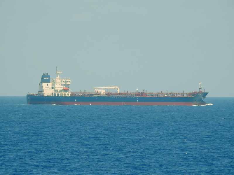
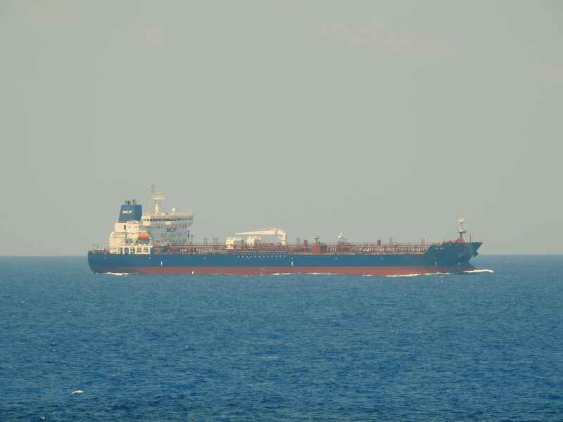
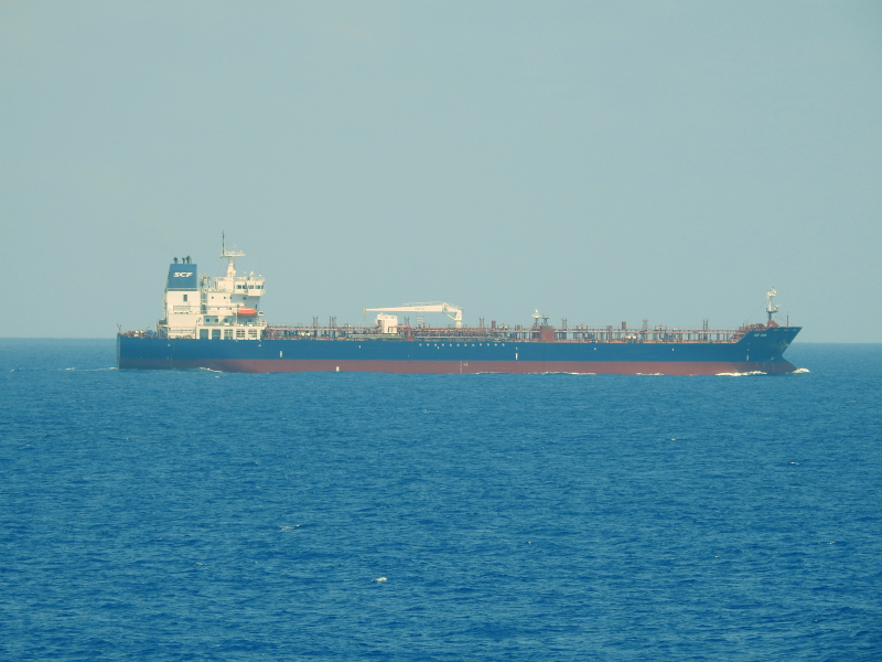
IMO 9385142
Vessel information
Sanctioned by
Company & Ownership
Management & Operations
Classification & Safety
Port State Control (PSC) Inspections
Survey Renewal & Certificates
| Code | Type | Issuer | Issued | Expires |
|---|---|---|---|---|
| 533 | Maritime Labour Certificate | Indian Register of Shipping (150) | 08/07/2024 | 28/06/2029 |
| 510 | Safety Management Certificate | Indian Register of Shipping (150) | 08/07/2024 | 28/06/2029 |
Programs & Notes
EU Russia Sanctions – Shadow Fleet | SEMA (Canada) — vessel designations | UKRAINE-EO13662] [RUSSIA-EO14024 | The Russia (Sanctions) (EU Exit) Regulations 2019
DateOfListing: 2025-05-21 || Secondary sanctions risk: See Section 11 of Executive Order 14024.; alt. Secondary sanctions risk: Ukraine-/Russia-Related Sanctions Regulations, 31 CFR 589.201 and/or 589.209; Vessel Year of Build 2009; Vessel Registration Identification IMO 9385142; MMSI 314946000; Linked To: JOINT STOCK COMPANY SOVCOMFLOT. || DateDesignated: 2025-07-21 | Shipping sanctions: (see “Other information”) | Shipping sanctions: a specified ship is prohibited from being provided with access to or having its master or pilot cause it to enter a port in the UK, may have its registration on the UK Ship Register terminated, and a master or pilot of a specified ship may be given a port barring direction, a detention direction, and a port entry direction or a movement direction. | IMO 9385142 (“Almond”) is, has been or is likely to be involved in activity whose object or effect is to destabilise Ukraine or undermine or threaten the territorial integrity, sovereignty or independence of Ukraine or to obtain a benefit from or support the Government of Russia. Namely, 9385142 is involved in carrying oil or oil products that originated in Russia from Russia to a third country.
Vessel Changes

AIS Events
50 events detected • 2 zones • Last: Jun 4, 2026
- Duration: 5h 45m
- Radius: 43 meters
- Data Points: 40 AIS positions
- Centroid: 31.5177, 32.3692
- Zone: Eastern Mediterranean Monitoring Zone
Show Raw Evidence JSON
{
    "radius_m": 43.2000000000000028421709430404007434844970703125,
    "duration_minutes": 345,
    "points": 40,
    "centroid": {
        "lat": 31.517746040000009344339559902437031269073486328125,
        "lon": 32.3691994999999934634615783579647541046142578125
    },
    "bbox": {
        "min_lat": 31.51765830000000079280653153546154499053955078125,
        "min_lon": 32.36877170000000347727109328843653202056884765625,
        "max_lat": 31.51787829999999956953615765087306499481201171875,
        "max_lon": 32.369581699999997681516106240451335906982421875
    },
    "zone_id": "discovered_020"
}- Zone: Eastern Mediterranean Monitoring Zone
- Duration: 5h 45m
- Data Points: 40 AIS positions
- Period: 2026-06-04T11:53:21+00:00 to 2026-06-04T17:38:20+00:00
Show Raw Evidence JSON
{
    "zone_id": "discovered_020",
    "zone_name": "Eastern Mediterranean Monitoring Zone",
    "dwell_minutes": 345,
    "points_in_zone": 40,
    "first_point": {
        "ts": "2026-06-04T11:53:21+00:00",
        "lat": 31.51780000000000114823706098832190036773681640625,
        "lon": 32.369581699999997681516106240451335906982421875
    },
    "last_point": {
        "ts": "2026-06-04T17:38:20+00:00",
        "lat": 31.51787829999999956953615765087306499481201171875,
        "lon": 32.36877170000000347727109328843653202056884765625
    }
}- Duration: 6h 30m
- Radius: 45 meters
- Data Points: 36 AIS positions
- Centroid: 31.5177, 32.3693
- Zone: Eastern Mediterranean Monitoring Zone
Show Raw Evidence JSON
{
    "radius_m": 45.2000000000000028421709430404007434844970703125,
    "duration_minutes": 390,
    "points": 36,
    "centroid": {
        "lat": 31.517737038888899547828259528614580631256103515625,
        "lon": 32.36926388611112059834340470843017101287841796875
    },
    "bbox": {
        "min_lat": 31.51765830000000079280653153546154499053955078125,
        "min_lon": 32.3689200000000028012436814606189727783203125,
        "max_lat": 31.5178267000000005282345227897167205810546875,
        "max_lon": 32.36973499999999859255694900639355182647705078125
    },
    "zone_id": "discovered_020"
}- Zone: Eastern Mediterranean Monitoring Zone
- Duration: 6h 30m
- Data Points: 36 AIS positions
- Period: 2026-06-04T10:32:21+00:00 to 2026-06-04T17:02:21+00:00
Show Raw Evidence JSON
{
    "zone_id": "discovered_020",
    "zone_name": "Eastern Mediterranean Monitoring Zone",
    "dwell_minutes": 390,
    "points_in_zone": 36,
    "first_point": {
        "ts": "2026-06-04T10:32:21+00:00",
        "lat": 31.517791700000000076897777034901082515716552734375,
        "lon": 32.36973499999999859255694900639355182647705078125
    },
    "last_point": {
        "ts": "2026-06-04T17:02:21+00:00",
        "lat": 31.517746700000000004138200893066823482513427734375,
        "lon": 32.3689200000000028012436814606189727783203125
    }
}- Duration: 6h 30m
- Radius: 40 meters
- Data Points: 36 AIS positions
- Centroid: 31.5177, 32.3693
- Zone: Eastern Mediterranean Monitoring Zone
Show Raw Evidence JSON
{
    "radius_m": 39.7000000000000028421709430404007434844970703125,
    "duration_minutes": 390,
    "points": 36,
    "centroid": {
        "lat": 31.517745697222228073997030151076614856719970703125,
        "lon": 32.36932096944445191866179811768233776092529296875
    },
    "bbox": {
        "min_lat": 31.51765830000000079280653153546154499053955078125,
        "min_lon": 32.368951699999996662882040254771709442138671875,
        "max_lat": 31.517875000000000085265128291212022304534912109375,
        "max_lon": 32.36973499999999859255694900639355182647705078125
    },
    "zone_id": "discovered_020"
}- Zone: Eastern Mediterranean Monitoring Zone
- Duration: 6h 30m
- Data Points: 36 AIS positions
- Period: 2026-06-04T09:59:21+00:00 to 2026-06-04T16:29:22+00:00
Show Raw Evidence JSON
{
    "zone_id": "discovered_020",
    "zone_name": "Eastern Mediterranean Monitoring Zone",
    "dwell_minutes": 390,
    "points_in_zone": 36,
    "first_point": {
        "ts": "2026-06-04T09:59:21+00:00",
        "lat": 31.517875000000000085265128291212022304534912109375,
        "lon": 32.369613299999997479972080327570438385009765625
    },
    "last_point": {
        "ts": "2026-06-04T16:29:22+00:00",
        "lat": 31.517753299999998972680259612388908863067626953125,
        "lon": 32.368951699999996662882040254771709442138671875
    }
}- Duration: 6h 27m
- Radius: 60 meters
- Data Points: 30 AIS positions
- Centroid: 31.5178, 32.3694
- Zone: Eastern Mediterranean Monitoring Zone
Show Raw Evidence JSON
{
    "radius_m": 60,
    "duration_minutes": 387.1000000000000227373675443232059478759765625,
    "points": 30,
    "centroid": {
        "lat": 31.517777390000009773984857019968330860137939453125,
        "lon": 32.36944177333333527712966315448284149169921875
    },
    "bbox": {
        "min_lat": 31.517676699999999101464709383435547351837158203125,
        "min_lon": 32.3691450000000031650415621697902679443359375,
        "max_lat": 31.51788330000000115660441224463284015655517578125,
        "max_lon": 32.37006170000000082609403762035071849822998046875
    },
    "zone_id": "discovered_020"
}- Zone: Eastern Mediterranean Monitoring Zone
- Duration: 6h 27m
- Data Points: 30 AIS positions
- Period: 2026-06-04T07:44:19+00:00 to 2026-06-04T14:11:22+00:00
Show Raw Evidence JSON
{
    "zone_id": "discovered_020",
    "zone_name": "Eastern Mediterranean Monitoring Zone",
    "dwell_minutes": 387.1000000000000227373675443232059478759765625,
    "points_in_zone": 30,
    "first_point": {
        "ts": "2026-06-04T07:44:19+00:00",
        "lat": 31.51788330000000115660441224463284015655517578125,
        "lon": 32.37006170000000082609403762035071849822998046875
    },
    "last_point": {
        "ts": "2026-06-04T14:11:22+00:00",
        "lat": 31.51771670000000113986970973201096057891845703125,
        "lon": 32.36925169999999951642166706733405590057373046875
    }
}- Minimum Distance: 2 meters
- Average Distance: 4 meters
- Duration: 31 minutes
- Period: 2026-06-03T11:43:23+00:00 to 2026-06-03T12:14:31+00:00
- Vessel A Avg Speed: 0.2 knots
- Vessel B Avg Speed: 0.0 knots
- Zone: Eastern Mediterranean Surveillance Zone
Confidence Analysis
Moderate-confidence STS candidate. Two tankers (ALMOND and DORIN) maintained close proximity (min 2m, avg 4m) for 31 minutes. Both vessels were slow-moving (avg speeds 0.2 and 0.0 knots). The stable separation distance suggests deliberate parallel positioning typical of cargo transfer. Event occurred in Eastern Mediterranean Surveillance Zone, a known STS activity area.
View scoring breakdown
| Factor | Score | Detail |
|---|---|---|
| Distance Tightness | 25/25 | Min distance 2m, avg 4m |
| Duration | 5/25 | Duration 31 minutes |
| Speed Stability | 20/20 | both nearly stationary; very stable speeds |
| Distance Consistency | 15/15 | Distance variance ±2m |
| Isolation | 5/10 | Isolation data not available |
| Context | 5/5 | In monitored zone: Eastern Mediterranean Surveillance Zone |
🛰️ Satellite Corroboration
No satellite imagery for this time/location
No Sentinel-1 scenes covering AOI and time window
Show Raw Evidence JSON
{
    "vessel_a": {
        "mmsi": 273276930,
        "imo": 9385142,
        "name": "ALMOND",
        "flag": "RUSSIA"
    },
    "vessel_b": {
        "mmsi": 613414203,
        "imo": 9290828,
        "name": "DORIN",
        "flag": "CAMEROON"
    },
    "min_distance_m": 2,
    "avg_distance_m": 4.4000000000000003552713678800500929355621337890625,
    "distance_consistency_m": 1.600000000000000088817841970012523233890533447265625,
    "duration_minutes": 31.10000000000000142108547152020037174224853515625,
    "overlap_duration_s": 1868,
    "speed_a_avg": 0.1700000000000000122124532708767219446599483489990234375,
    "speed_a_std": 0.1700000000000000122124532708767219446599483489990234375,
    "speed_b_avg": 0.0299999999999999988897769753748434595763683319091796875,
    "speed_b_std": 0.05000000000000000277555756156289135105907917022705078125,
    "speed_summary": {
        "vessel_a": {
            "avg_sog": 0.1700000000000000122124532708767219446599483489990234375,
            "max_sog": 0.40000000000000002220446049250313080847263336181640625
        },
        "vessel_b": {
            "avg_sog": 0.0299999999999999988897769753748434595763683319091796875,
            "max_sog": 0.1000000000000000055511151231257827021181583404541015625
        }
    },
    "time_window": {
        "start": "2026-06-03T11:43:23+00:00",
        "end": "2026-06-03T12:14:31+00:00"
    },
    "points_count": {
        "vessel_a": 4,
        "vessel_b": 4
    },
    "zone_id": "discovered_138",
    "zone_name": "Eastern Mediterranean Surveillance Zone",
    "score": {
        "value": 75,
        "components": {
            "distance_tightness": {
                "score": 25,
                "max": 25,
                "detail": "Min distance 2m, avg 4m"
            },
            "duration": {
                "score": 5,
                "max": 25,
                "detail": "Duration 31 minutes"
            },
            "speed_stability": {
                "score": 20,
                "max": 20,
                "detail": "both nearly stationary; very stable speeds"
            },
            "distance_consistency": {
                "score": 15,
                "max": 15,
                "detail": "Distance variance \u00b12m"
            },
            "isolation": {
                "score": 5,
                "max": 10,
                "detail": "Isolation data not available"
            },
            "context": {
                "score": 5,
                "max": 5,
                "detail": "In monitored zone: Eastern Mediterranean Surveillance Zone"
            }
        },
        "summary": "Moderate-confidence STS candidate. Two tankers (ALMOND and DORIN) maintained close proximity (min 2m, avg 4m) for 31 minutes. Both vessels were slow-moving (avg speeds 0.2 and 0.0 knots). The stable separation distance suggests deliberate parallel positioning typical of cargo transfer. Event occurred in Eastern Mediterranean Surveillance Zone, a known STS activity area."
    },
    "sar": {
        "status": "not_found",
        "centroid": {
            "lat": 31.717089800000000110458131530322134494781494140625,
            "lon": 35.9993764999999967812982504256069660186767578125
        },
        "time_window": {
            "start_ts": "2026-06-03T11:43:23+00:00",
            "end_ts": "2026-06-03T12:14:31+00:00"
        },
        "searched_at": "2026-06-03T19:30:04.824428+00:00",
        "notes": "No Sentinel-1 scenes covering AOI and time window"
    }
}- Minimum Distance: 2 meters
- Average Distance: 4 meters
- Duration: 31 minutes
- Period: 2026-06-03T11:43:23+00:00 to 2026-06-03T12:14:31+00:00
- Vessel A Avg Speed: 0.2 knots
- Vessel B Avg Speed: 0.0 knots
- Zone: Eastern Mediterranean Surveillance Zone
Confidence Analysis
Moderate-confidence STS candidate. Two tankers (ALMOND and MILANO) maintained close proximity (min 2m, avg 4m) for 31 minutes. Both vessels were slow-moving (avg speeds 0.2 and 0.0 knots). The stable separation distance suggests deliberate parallel positioning typical of cargo transfer. Event occurred in Eastern Mediterranean Surveillance Zone, a known STS activity area.
View scoring breakdown
| Factor | Score | Detail |
|---|---|---|
| Distance Tightness | 25/25 | Min distance 2m, avg 4m |
| Duration | 5/25 | Duration 31 minutes |
| Speed Stability | 20/20 | both nearly stationary; very stable speeds |
| Distance Consistency | 15/15 | Distance variance ±2m |
| Isolation | 5/10 | Isolation data not available |
| Context | 5/5 | In monitored zone: Eastern Mediterranean Surveillance Zone |
🛰️ Satellite Corroboration
No satellite imagery for this time/location
No Sentinel-1 scenes covering AOI and time window
Show Raw Evidence JSON
{
    "vessel_a": {
        "mmsi": 273276930,
        "imo": 9385142,
        "name": "ALMOND",
        "flag": "RUSSIA"
    },
    "vessel_b": {
        "mmsi": 636022825,
        "imo": 9286059,
        "name": "MILANO",
        "flag": "LIBERIA"
    },
    "min_distance_m": 1.5,
    "avg_distance_m": 3.79999999999999982236431605997495353221893310546875,
    "distance_consistency_m": 1.8000000000000000444089209850062616169452667236328125,
    "duration_minutes": 31.10000000000000142108547152020037174224853515625,
    "overlap_duration_s": 1868,
    "speed_a_avg": 0.1700000000000000122124532708767219446599483489990234375,
    "speed_a_std": 0.1700000000000000122124532708767219446599483489990234375,
    "speed_b_avg": 0,
    "speed_b_std": 0,
    "speed_summary": {
        "vessel_a": {
            "avg_sog": 0.1700000000000000122124532708767219446599483489990234375,
            "max_sog": 0.40000000000000002220446049250313080847263336181640625
        },
        "vessel_b": {
            "avg_sog": 0,
            "max_sog": 0
        }
    },
    "time_window": {
        "start": "2026-06-03T11:43:23+00:00",
        "end": "2026-06-03T12:14:31+00:00"
    },
    "points_count": {
        "vessel_a": 4,
        "vessel_b": 4
    },
    "zone_id": "discovered_138",
    "zone_name": "Eastern Mediterranean Surveillance Zone",
    "score": {
        "value": 75,
        "components": {
            "distance_tightness": {
                "score": 25,
                "max": 25,
                "detail": "Min distance 2m, avg 4m"
            },
            "duration": {
                "score": 5,
                "max": 25,
                "detail": "Duration 31 minutes"
            },
            "speed_stability": {
                "score": 20,
                "max": 20,
                "detail": "both nearly stationary; very stable speeds"
            },
            "distance_consistency": {
                "score": 15,
                "max": 15,
                "detail": "Distance variance \u00b12m"
            },
            "isolation": {
                "score": 5,
                "max": 10,
                "detail": "Isolation data not available"
            },
            "context": {
                "score": 5,
                "max": 5,
                "detail": "In monitored zone: Eastern Mediterranean Surveillance Zone"
            }
        },
        "summary": "Moderate-confidence STS candidate. Two tankers (ALMOND and MILANO) maintained close proximity (min 2m, avg 4m) for 31 minutes. Both vessels were slow-moving (avg speeds 0.2 and 0.0 knots). The stable separation distance suggests deliberate parallel positioning typical of cargo transfer. Event occurred in Eastern Mediterranean Surveillance Zone, a known STS activity area."
    },
    "sar": {
        "status": "not_found",
        "centroid": {
            "lat": 31.717093399999999547844709013588726520538330078125,
            "lon": 35.999372899999997343911672942340373992919921875
        },
        "time_window": {
            "start_ts": "2026-06-03T11:43:23+00:00",
            "end_ts": "2026-06-03T12:14:31+00:00"
        },
        "searched_at": "2026-06-03T19:15:11.893636+00:00",
        "notes": "No Sentinel-1 scenes covering AOI and time window"
    }
}- Minimum Distance: 2 meters
- Average Distance: 4 meters
- Duration: 31 minutes
- Period: 2026-06-03T11:43:23+00:00 to 2026-06-03T12:14:31+00:00
- Vessel A Avg Speed: 0.2 knots
- Vessel B Avg Speed: 0.0 knots
- Zone: Eastern Mediterranean Surveillance Zone
Confidence Analysis
Moderate-confidence STS candidate. Two tankers (ALMOND and ILAN) maintained close proximity (min 2m, avg 4m) for 31 minutes. Both vessels were slow-moving (avg speeds 0.2 and 0.0 knots). The stable separation distance suggests deliberate parallel positioning typical of cargo transfer. Event occurred in Eastern Mediterranean Surveillance Zone, a known STS activity area.
View scoring breakdown
| Factor | Score | Detail |
|---|---|---|
| Distance Tightness | 25/25 | Min distance 2m, avg 4m |
| Duration | 5/25 | Duration 31 minutes |
| Speed Stability | 20/20 | both nearly stationary; very stable speeds |
| Distance Consistency | 15/15 | Distance variance ±1m |
| Isolation | 5/10 | Isolation data not available |
| Context | 5/5 | In monitored zone: Eastern Mediterranean Surveillance Zone |
🛰️ Satellite Corroboration
No satellite imagery for this time/location
No Sentinel-1 scenes covering AOI and time window
Show Raw Evidence JSON
{
    "vessel_a": {
        "mmsi": 273276930,
        "imo": 9385142,
        "name": "ALMOND",
        "flag": "RUSSIA"
    },
    "vessel_b": {
        "mmsi": 636025684,
        "imo": 9282510,
        "name": "ILAN",
        "flag": "Liberia"
    },
    "min_distance_m": 2.20000000000000017763568394002504646778106689453125,
    "avg_distance_m": 4.20000000000000017763568394002504646778106689453125,
    "distance_consistency_m": 1.3000000000000000444089209850062616169452667236328125,
    "duration_minutes": 31.10000000000000142108547152020037174224853515625,
    "overlap_duration_s": 1868,
    "speed_a_avg": 0.1700000000000000122124532708767219446599483489990234375,
    "speed_a_std": 0.1700000000000000122124532708767219446599483489990234375,
    "speed_b_avg": 0,
    "speed_b_std": 0,
    "speed_summary": {
        "vessel_a": {
            "avg_sog": 0.1700000000000000122124532708767219446599483489990234375,
            "max_sog": 0.40000000000000002220446049250313080847263336181640625
        },
        "vessel_b": {
            "avg_sog": 0,
            "max_sog": 0
        }
    },
    "time_window": {
        "start": "2026-06-03T11:43:23+00:00",
        "end": "2026-06-03T12:14:31+00:00"
    },
    "points_count": {
        "vessel_a": 4,
        "vessel_b": 4
    },
    "zone_id": "discovered_138",
    "zone_name": "Eastern Mediterranean Surveillance Zone",
    "score": {
        "value": 75,
        "components": {
            "distance_tightness": {
                "score": 25,
                "max": 25,
                "detail": "Min distance 2m, avg 4m"
            },
            "duration": {
                "score": 5,
                "max": 25,
                "detail": "Duration 31 minutes"
            },
            "speed_stability": {
                "score": 20,
                "max": 20,
                "detail": "both nearly stationary; very stable speeds"
            },
            "distance_consistency": {
                "score": 15,
                "max": 15,
                "detail": "Distance variance \u00b11m"
            },
            "isolation": {
                "score": 5,
                "max": 10,
                "detail": "Isolation data not available"
            },
            "context": {
                "score": 5,
                "max": 5,
                "detail": "In monitored zone: Eastern Mediterranean Surveillance Zone"
            }
        },
        "summary": "Moderate-confidence STS candidate. Two tankers (ALMOND and ILAN) maintained close proximity (min 2m, avg 4m) for 31 minutes. Both vessels were slow-moving (avg speeds 0.2 and 0.0 knots). The stable separation distance suggests deliberate parallel positioning typical of cargo transfer. Event occurred in Eastern Mediterranean Surveillance Zone, a known STS activity area."
    },
    "sar": {
        "status": "not_found",
        "centroid": {
            "lat": 31.71709309999999959472916088998317718505859375,
            "lon": 35.9993778999999989309799275361001491546630859375
        },
        "time_window": {
            "start_ts": "2026-06-03T11:43:23+00:00",
            "end_ts": "2026-06-03T12:14:31+00:00"
        },
        "searched_at": "2026-06-03T19:15:09.083564+00:00",
        "notes": "No Sentinel-1 scenes covering AOI and time window"
    }
}- Minimum Distance: 2 meters
- Average Distance: 3 meters
- Duration: 31 minutes
- Period: 2026-06-03T11:43:23+00:00 to 2026-06-03T12:14:31+00:00
- Vessel A Avg Speed: 0.2 knots
- Vessel B Avg Speed: 0.5 knots
- Zone: Eastern Mediterranean Surveillance Zone
Confidence Analysis
Moderate-confidence STS candidate. Two tankers (ALMOND and NAVE AMARYLLIS) maintained close proximity (min 2m, avg 3m) for 31 minutes. Both vessels were slow-moving (avg speeds 0.2 and 0.5 knots). The stable separation distance suggests deliberate parallel positioning typical of cargo transfer. Event occurred in Eastern Mediterranean Surveillance Zone, a known STS activity area.
View scoring breakdown
| Factor | Score | Detail |
|---|---|---|
| Distance Tightness | 25/25 | Min distance 2m, avg 3m |
| Duration | 5/25 | Duration 31 minutes |
| Speed Stability | 15/20 | both very slow; stable speeds |
| Distance Consistency | 15/15 | Distance variance ±1m |
| Isolation | 5/10 | Isolation data not available |
| Context | 5/5 | In monitored zone: Eastern Mediterranean Surveillance Zone |
🛰️ Satellite Corroboration
No satellite imagery for this time/location
No Sentinel-1 scenes covering AOI and time window
Show Raw Evidence JSON
{
    "vessel_a": {
        "mmsi": 273276930,
        "imo": 9385142,
        "name": "ALMOND",
        "flag": "RUSSIA"
    },
    "vessel_b": {
        "mmsi": 636026072,
        "imo": 1059644,
        "name": "NAVE AMARYLLIS",
        "flag": "LIBERIA"
    },
    "min_distance_m": 1.899999999999999911182158029987476766109466552734375,
    "avg_distance_m": 3.399999999999999911182158029987476766109466552734375,
    "distance_consistency_m": 1.100000000000000088817841970012523233890533447265625,
    "duration_minutes": 31.10000000000000142108547152020037174224853515625,
    "overlap_duration_s": 1868,
    "speed_a_avg": 0.1700000000000000122124532708767219446599483489990234375,
    "speed_a_std": 0.1700000000000000122124532708767219446599483489990234375,
    "speed_b_avg": 0.520000000000000017763568394002504646778106689453125,
    "speed_b_std": 0.35999999999999998667732370449812151491641998291015625,
    "speed_summary": {
        "vessel_a": {
            "avg_sog": 0.1700000000000000122124532708767219446599483489990234375,
            "max_sog": 0.40000000000000002220446049250313080847263336181640625
        },
        "vessel_b": {
            "avg_sog": 0.520000000000000017763568394002504646778106689453125,
            "max_sog": 0.8000000000000000444089209850062616169452667236328125
        }
    },
    "time_window": {
        "start": "2026-06-03T11:43:23+00:00",
        "end": "2026-06-03T12:14:31+00:00"
    },
    "points_count": {
        "vessel_a": 4,
        "vessel_b": 4
    },
    "zone_id": "discovered_138",
    "zone_name": "Eastern Mediterranean Surveillance Zone",
    "score": {
        "value": 70,
        "components": {
            "distance_tightness": {
                "score": 25,
                "max": 25,
                "detail": "Min distance 2m, avg 3m"
            },
            "duration": {
                "score": 5,
                "max": 25,
                "detail": "Duration 31 minutes"
            },
            "speed_stability": {
                "score": 15,
                "max": 20,
                "detail": "both very slow; stable speeds"
            },
            "distance_consistency": {
                "score": 15,
                "max": 15,
                "detail": "Distance variance \u00b11m"
            },
            "isolation": {
                "score": 5,
                "max": 10,
                "detail": "Isolation data not available"
            },
            "context": {
                "score": 5,
                "max": 5,
                "detail": "In monitored zone: Eastern Mediterranean Surveillance Zone"
            }
        },
        "summary": "Moderate-confidence STS candidate. Two tankers (ALMOND and NAVE AMARYLLIS) maintained close proximity (min 2m, avg 3m) for 31 minutes. Both vessels were slow-moving (avg speeds 0.2 and 0.5 knots). The stable separation distance suggests deliberate parallel positioning typical of cargo transfer. Event occurred in Eastern Mediterranean Surveillance Zone, a known STS activity area."
    },
    "sar": {
        "status": "not_found",
        "centroid": {
            "lat": 31.71708879999999908250174485146999359130859375,
            "lon": 35.9993740000000030931914807297289371490478515625
        },
        "time_window": {
            "start_ts": "2026-06-03T11:43:23+00:00",
            "end_ts": "2026-06-03T12:14:31+00:00"
        },
        "searched_at": "2026-06-03T19:00:02.150674+00:00",
        "notes": "No Sentinel-1 scenes covering AOI and time window"
    }
}- Minimum Distance: 2 meters
- Average Distance: 4 meters
- Duration: 31 minutes
- Period: 2026-06-03T11:43:23+00:00 to 2026-06-03T12:14:31+00:00
- Vessel A Avg Speed: 0.2 knots
- Vessel B Avg Speed: 0.1 knots
- Zone: Eastern Mediterranean Surveillance Zone
Confidence Analysis
Moderate-confidence STS candidate. Two tankers (ALMOND and GEORGY MASLOV) maintained close proximity (min 2m, avg 4m) for 31 minutes. Both vessels were slow-moving (avg speeds 0.2 and 0.1 knots). The stable separation distance suggests deliberate parallel positioning typical of cargo transfer. Event occurred in Eastern Mediterranean Surveillance Zone, a known STS activity area.
View scoring breakdown
| Factor | Score | Detail |
|---|---|---|
| Distance Tightness | 25/25 | Min distance 2m, avg 4m |
| Duration | 5/25 | Duration 31 minutes |
| Speed Stability | 20/20 | both nearly stationary; very stable speeds |
| Distance Consistency | 15/15 | Distance variance ±2m |
| Isolation | 5/10 | Isolation data not available |
| Context | 5/5 | In monitored zone: Eastern Mediterranean Surveillance Zone |
🛰️ Satellite Corroboration
No satellite imagery for this time/location
No Sentinel-1 scenes covering AOI and time window
Show Raw Evidence JSON
{
    "vessel_a": {
        "mmsi": 273276930,
        "imo": 9385142,
        "name": "ALMOND",
        "flag": "RUSSIA"
    },
    "vessel_b": {
        "mmsi": 273259730,
        "imo": 9610793,
        "name": "GEORGY MASLOV",
        "flag": "RUSSIA"
    },
    "min_distance_m": 1.899999999999999911182158029987476766109466552734375,
    "avg_distance_m": 4.20000000000000017763568394002504646778106689453125,
    "distance_consistency_m": 1.5,
    "duration_minutes": 31.10000000000000142108547152020037174224853515625,
    "overlap_duration_s": 1868,
    "speed_a_avg": 0.1700000000000000122124532708767219446599483489990234375,
    "speed_a_std": 0.1700000000000000122124532708767219446599483489990234375,
    "speed_b_avg": 0.05000000000000000277555756156289135105907917022705078125,
    "speed_b_std": 0.1000000000000000055511151231257827021181583404541015625,
    "speed_summary": {
        "vessel_a": {
            "avg_sog": 0.1700000000000000122124532708767219446599483489990234375,
            "max_sog": 0.40000000000000002220446049250313080847263336181640625
        },
        "vessel_b": {
            "avg_sog": 0.05000000000000000277555756156289135105907917022705078125,
            "max_sog": 0.200000000000000011102230246251565404236316680908203125
        }
    },
    "time_window": {
        "start": "2026-06-03T11:43:23+00:00",
        "end": "2026-06-03T12:14:31+00:00"
    },
    "points_count": {
        "vessel_a": 4,
        "vessel_b": 4
    },
    "zone_id": "discovered_138",
    "zone_name": "Eastern Mediterranean Surveillance Zone",
    "score": {
        "value": 75,
        "components": {
            "distance_tightness": {
                "score": 25,
                "max": 25,
                "detail": "Min distance 2m, avg 4m"
            },
            "duration": {
                "score": 5,
                "max": 25,
                "detail": "Duration 31 minutes"
            },
            "speed_stability": {
                "score": 20,
                "max": 20,
                "detail": "both nearly stationary; very stable speeds"
            },
            "distance_consistency": {
                "score": 15,
                "max": 15,
                "detail": "Distance variance \u00b12m"
            },
            "isolation": {
                "score": 5,
                "max": 10,
                "detail": "Isolation data not available"
            },
            "context": {
                "score": 5,
                "max": 5,
                "detail": "In monitored zone: Eastern Mediterranean Surveillance Zone"
            }
        },
        "summary": "Moderate-confidence STS candidate. Two tankers (ALMOND and GEORGY MASLOV) maintained close proximity (min 2m, avg 4m) for 31 minutes. Both vessels were slow-moving (avg speeds 0.2 and 0.1 knots). The stable separation distance suggests deliberate parallel positioning typical of cargo transfer. Event occurred in Eastern Mediterranean Surveillance Zone, a known STS activity area."
    },
    "sar": {
        "status": "not_found",
        "centroid": {
            "lat": 31.717097100000000153841028804890811443328857421875,
            "lon": 35.99936919999999673791535315103828907012939453125
        },
        "time_window": {
            "start_ts": "2026-06-03T11:43:23+00:00",
            "end_ts": "2026-06-03T12:14:31+00:00"
        },
        "searched_at": "2026-06-03T18:45:12.805518+00:00",
        "notes": "No Sentinel-1 scenes covering AOI and time window"
    }
}- Minimum Distance: 2 meters
- Average Distance: 3 meters
- Duration: 31 minutes
- Period: 2026-06-03T11:43:23+00:00 to 2026-06-03T12:14:31+00:00
- Vessel A Avg Speed: 0.2 knots
- Vessel B Avg Speed: 0.0 knots
- Zone: Eastern Mediterranean Surveillance Zone
Confidence Analysis
Moderate-confidence STS candidate. Two tankers (ALMOND and THALIA) maintained close proximity (min 2m, avg 3m) for 31 minutes. Both vessels were slow-moving (avg speeds 0.2 and 0.0 knots). The stable separation distance suggests deliberate parallel positioning typical of cargo transfer. Event occurred in Eastern Mediterranean Surveillance Zone, a known STS activity area.
View scoring breakdown
| Factor | Score | Detail |
|---|---|---|
| Distance Tightness | 25/25 | Min distance 2m, avg 3m |
| Duration | 5/25 | Duration 31 minutes |
| Speed Stability | 20/20 | both nearly stationary; very stable speeds |
| Distance Consistency | 15/15 | Distance variance ±2m |
| Isolation | 5/10 | Isolation data not available |
| Context | 5/5 | In monitored zone: Eastern Mediterranean Surveillance Zone |
🛰️ Satellite Corroboration
No satellite imagery for this time/location
No Sentinel-1 scenes covering AOI and time window
Show Raw Evidence JSON
{
    "vessel_a": {
        "mmsi": 273276930,
        "imo": 9385142,
        "name": "ALMOND",
        "flag": "RUSSIA"
    },
    "vessel_b": {
        "mmsi": 636015372,
        "imo": 9611541,
        "name": "THALIA",
        "flag": "Liberia"
    },
    "min_distance_m": 1.5,
    "avg_distance_m": 3,
    "distance_consistency_m": 1.600000000000000088817841970012523233890533447265625,
    "duration_minutes": 31.10000000000000142108547152020037174224853515625,
    "overlap_duration_s": 1868,
    "speed_a_avg": 0.1700000000000000122124532708767219446599483489990234375,
    "speed_a_std": 0.1700000000000000122124532708767219446599483489990234375,
    "speed_b_avg": 0,
    "speed_b_std": 0,
    "speed_summary": {
        "vessel_a": {
            "avg_sog": 0.1700000000000000122124532708767219446599483489990234375,
            "max_sog": 0.40000000000000002220446049250313080847263336181640625
        },
        "vessel_b": {
            "avg_sog": 0,
            "max_sog": 0
        }
    },
    "time_window": {
        "start": "2026-06-03T11:43:23+00:00",
        "end": "2026-06-03T12:14:31+00:00"
    },
    "points_count": {
        "vessel_a": 4,
        "vessel_b": 4
    },
    "zone_id": "discovered_138",
    "zone_name": "Eastern Mediterranean Surveillance Zone",
    "score": {
        "value": 75,
        "components": {
            "distance_tightness": {
                "score": 25,
                "max": 25,
                "detail": "Min distance 2m, avg 3m"
            },
            "duration": {
                "score": 5,
                "max": 25,
                "detail": "Duration 31 minutes"
            },
            "speed_stability": {
                "score": 20,
                "max": 20,
                "detail": "both nearly stationary; very stable speeds"
            },
            "distance_consistency": {
                "score": 15,
                "max": 15,
                "detail": "Distance variance \u00b12m"
            },
            "isolation": {
                "score": 5,
                "max": 10,
                "detail": "Isolation data not available"
            },
            "context": {
                "score": 5,
                "max": 5,
                "detail": "In monitored zone: Eastern Mediterranean Surveillance Zone"
            }
        },
        "summary": "Moderate-confidence STS candidate. Two tankers (ALMOND and THALIA) maintained close proximity (min 2m, avg 3m) for 31 minutes. Both vessels were slow-moving (avg speeds 0.2 and 0.0 knots). The stable separation distance suggests deliberate parallel positioning typical of cargo transfer. Event occurred in Eastern Mediterranean Surveillance Zone, a known STS activity area."
    },
    "sar": {
        "status": "not_found",
        "centroid": {
            "lat": 31.717090400000000016689227777533233165740966796875,
            "lon": 35.99937109999999762521838420070707798004150390625
        },
        "time_window": {
            "start_ts": "2026-06-03T11:43:23+00:00",
            "end_ts": "2026-06-03T12:14:31+00:00"
        },
        "searched_at": "2026-06-03T18:45:04.994600+00:00",
        "notes": "No Sentinel-1 scenes covering AOI and time window"
    }
}- Minimum Distance: 3 meters
- Average Distance: 5 meters
- Duration: 31 minutes
- Period: 2026-06-03T11:43:23+00:00 to 2026-06-03T12:14:31+00:00
- Vessel A Avg Speed: 0.2 knots
- Vessel B Avg Speed: 0.0 knots
- Zone: Eastern Mediterranean Surveillance Zone
Confidence Analysis
Moderate-confidence STS candidate. Two tankers (ALMOND and HYPERION) maintained close proximity (min 3m, avg 5m) for 31 minutes. Both vessels were slow-moving (avg speeds 0.2 and 0.0 knots). The stable separation distance suggests deliberate parallel positioning typical of cargo transfer. Event occurred in Eastern Mediterranean Surveillance Zone, a known STS activity area.
View scoring breakdown
| Factor | Score | Detail |
|---|---|---|
| Distance Tightness | 25/25 | Min distance 3m, avg 5m |
| Duration | 5/25 | Duration 31 minutes |
| Speed Stability | 20/20 | both nearly stationary; very stable speeds |
| Distance Consistency | 15/15 | Distance variance ±2m |
| Isolation | 5/10 | Isolation data not available |
| Context | 5/5 | In monitored zone: Eastern Mediterranean Surveillance Zone |
🛰️ Satellite Corroboration
No satellite imagery for this time/location
No Sentinel-1 scenes covering AOI and time window
Show Raw Evidence JSON
{
    "vessel_a": {
        "mmsi": 273276930,
        "imo": 9385142,
        "name": "ALMOND",
        "flag": "RUSSIA"
    },
    "vessel_b": {
        "mmsi": 273278750,
        "imo": 9322968,
        "name": "HYPERION",
        "flag": "Russia"
    },
    "min_distance_m": 3,
    "avg_distance_m": 4.79999999999999982236431605997495353221893310546875,
    "distance_consistency_m": 1.5,
    "duration_minutes": 31.10000000000000142108547152020037174224853515625,
    "overlap_duration_s": 1868,
    "speed_a_avg": 0.1700000000000000122124532708767219446599483489990234375,
    "speed_a_std": 0.1700000000000000122124532708767219446599483489990234375,
    "speed_b_avg": 0,
    "speed_b_std": 0,
    "speed_summary": {
        "vessel_a": {
            "avg_sog": 0.1700000000000000122124532708767219446599483489990234375,
            "max_sog": 0.40000000000000002220446049250313080847263336181640625
        },
        "vessel_b": {
            "avg_sog": 0,
            "max_sog": 0
        }
    },
    "time_window": {
        "start": "2026-06-03T11:43:23+00:00",
        "end": "2026-06-03T12:14:31+00:00"
    },
    "points_count": {
        "vessel_a": 4,
        "vessel_b": 4
    },
    "zone_id": "discovered_138",
    "zone_name": "Eastern Mediterranean Surveillance Zone",
    "score": {
        "value": 75,
        "components": {
            "distance_tightness": {
                "score": 25,
                "max": 25,
                "detail": "Min distance 3m, avg 5m"
            },
            "duration": {
                "score": 5,
                "max": 25,
                "detail": "Duration 31 minutes"
            },
            "speed_stability": {
                "score": 20,
                "max": 20,
                "detail": "both nearly stationary; very stable speeds"
            },
            "distance_consistency": {
                "score": 15,
                "max": 15,
                "detail": "Distance variance \u00b12m"
            },
            "isolation": {
                "score": 5,
                "max": 10,
                "detail": "Isolation data not available"
            },
            "context": {
                "score": 5,
                "max": 5,
                "detail": "In monitored zone: Eastern Mediterranean Surveillance Zone"
            }
        },
        "summary": "Moderate-confidence STS candidate. Two tankers (ALMOND and HYPERION) maintained close proximity (min 3m, avg 5m) for 31 minutes. Both vessels were slow-moving (avg speeds 0.2 and 0.0 knots). The stable separation distance suggests deliberate parallel positioning typical of cargo transfer. Event occurred in Eastern Mediterranean Surveillance Zone, a known STS activity area."
    },
    "sar": {
        "status": "not_found",
        "centroid": {
            "lat": 31.717100200000000853606252348981797695159912109375,
            "lon": 35.99937129999999996243786881677806377410888671875
        },
        "time_window": {
            "start_ts": "2026-06-03T11:43:23+00:00",
            "end_ts": "2026-06-03T12:14:31+00:00"
        },
        "searched_at": "2026-06-03T17:30:01.275803+00:00",
        "notes": "No Sentinel-1 scenes covering AOI and time window"
    }
}- Minimum Distance: 2 meters
- Average Distance: 3 meters
- Duration: 31 minutes
- Period: 2026-06-03T11:43:23+00:00 to 2026-06-03T12:14:31+00:00
- Vessel A Avg Speed: 0.2 knots
- Vessel B Avg Speed: 0.0 knots
- Zone: Eastern Mediterranean Surveillance Zone
Confidence Analysis
Moderate-confidence STS candidate. Two tankers (ALMOND and TRANS FJORD) maintained close proximity (min 2m, avg 3m) for 31 minutes. Both vessels were slow-moving (avg speeds 0.2 and 0.0 knots). The stable separation distance suggests deliberate parallel positioning typical of cargo transfer. Event occurred in Eastern Mediterranean Surveillance Zone, a known STS activity area.
View scoring breakdown
| Factor | Score | Detail |
|---|---|---|
| Distance Tightness | 25/25 | Min distance 2m, avg 3m |
| Duration | 5/25 | Duration 31 minutes |
| Speed Stability | 20/20 | both nearly stationary; very stable speeds |
| Distance Consistency | 15/15 | Distance variance ±1m |
| Isolation | 5/10 | Isolation data not available |
| Context | 5/5 | In monitored zone: Eastern Mediterranean Surveillance Zone |
🛰️ Satellite Corroboration
No satellite imagery for this time/location
No Sentinel-1 scenes covering AOI and time window
Show Raw Evidence JSON
{
    "vessel_a": {
        "mmsi": 273276930,
        "imo": 9385142,
        "name": "ALMOND",
        "flag": "RUSSIA"
    },
    "vessel_b": {
        "mmsi": 352003272,
        "imo": 9956939,
        "name": "TRANS FJORD",
        "flag": "Panama"
    },
    "min_distance_m": 1.600000000000000088817841970012523233890533447265625,
    "avg_distance_m": 3,
    "distance_consistency_m": 1.399999999999999911182158029987476766109466552734375,
    "duration_minutes": 31.10000000000000142108547152020037174224853515625,
    "overlap_duration_s": 1868,
    "speed_a_avg": 0.1700000000000000122124532708767219446599483489990234375,
    "speed_a_std": 0.1700000000000000122124532708767219446599483489990234375,
    "speed_b_avg": 0,
    "speed_b_std": 0,
    "speed_summary": {
        "vessel_a": {
            "avg_sog": 0.1700000000000000122124532708767219446599483489990234375,
            "max_sog": 0.40000000000000002220446049250313080847263336181640625
        },
        "vessel_b": {
            "avg_sog": 0,
            "max_sog": 0
        }
    },
    "time_window": {
        "start": "2026-06-03T11:43:23+00:00",
        "end": "2026-06-03T12:14:31+00:00"
    },
    "points_count": {
        "vessel_a": 4,
        "vessel_b": 4
    },
    "zone_id": "discovered_138",
    "zone_name": "Eastern Mediterranean Surveillance Zone",
    "score": {
        "value": 75,
        "components": {
            "distance_tightness": {
                "score": 25,
                "max": 25,
                "detail": "Min distance 2m, avg 3m"
            },
            "duration": {
                "score": 5,
                "max": 25,
                "detail": "Duration 31 minutes"
            },
            "speed_stability": {
                "score": 20,
                "max": 20,
                "detail": "both nearly stationary; very stable speeds"
            },
            "distance_consistency": {
                "score": 15,
                "max": 15,
                "detail": "Distance variance \u00b11m"
            },
            "isolation": {
                "score": 5,
                "max": 10,
                "detail": "Isolation data not available"
            },
            "context": {
                "score": 5,
                "max": 5,
                "detail": "In monitored zone: Eastern Mediterranean Surveillance Zone"
            }
        },
        "summary": "Moderate-confidence STS candidate. Two tankers (ALMOND and TRANS FJORD) maintained close proximity (min 2m, avg 3m) for 31 minutes. Both vessels were slow-moving (avg speeds 0.2 and 0.0 knots). The stable separation distance suggests deliberate parallel positioning typical of cargo transfer. Event occurred in Eastern Mediterranean Surveillance Zone, a known STS activity area."
    },
    "sar": {
        "status": "not_found",
        "centroid": {
            "lat": 31.7170890000000014197212294675409793853759765625,
            "lon": 35.99937109999999762521838420070707798004150390625
        },
        "time_window": {
            "start_ts": "2026-06-03T11:43:23+00:00",
            "end_ts": "2026-06-03T12:14:31+00:00"
        },
        "searched_at": "2026-06-03T18:45:02.198905+00:00",
        "notes": "No Sentinel-1 scenes covering AOI and time window"
    }
}- Minimum Distance: 2 meters
- Average Distance: 3 meters
- Duration: 31 minutes
- Period: 2026-06-03T11:43:23+00:00 to 2026-06-03T12:14:31+00:00
- Vessel A Avg Speed: 0.2 knots
- Vessel B Avg Speed: 0.0 knots
- Zone: Eastern Mediterranean Surveillance Zone
Confidence Analysis
Moderate-confidence STS candidate. Two tankers (ALMOND and NISSOS SERIFOS) maintained close proximity (min 2m, avg 3m) for 31 minutes. Both vessels were slow-moving (avg speeds 0.2 and 0.0 knots). The stable separation distance suggests deliberate parallel positioning typical of cargo transfer. Event occurred in Eastern Mediterranean Surveillance Zone, a known STS activity area.
View scoring breakdown
| Factor | Score | Detail |
|---|---|---|
| Distance Tightness | 25/25 | Min distance 2m, avg 3m |
| Duration | 5/25 | Duration 31 minutes |
| Speed Stability | 20/20 | both nearly stationary; very stable speeds |
| Distance Consistency | 15/15 | Distance variance ±1m |
| Isolation | 5/10 | Isolation data not available |
| Context | 5/5 | In monitored zone: Eastern Mediterranean Surveillance Zone |
🛰️ Satellite Corroboration
No satellite imagery for this time/location
No Sentinel-1 scenes covering AOI and time window
Show Raw Evidence JSON
{
    "vessel_a": {
        "mmsi": 273276930,
        "imo": 9385142,
        "name": "ALMOND",
        "flag": "RUSSIA"
    },
    "vessel_b": {
        "mmsi": 538010371,
        "imo": 9592264,
        "name": "NISSOS SERIFOS",
        "flag": "MARSHALL ISLANDS"
    },
    "min_distance_m": 1.5,
    "avg_distance_m": 2.899999999999999911182158029987476766109466552734375,
    "distance_consistency_m": 1.1999999999999999555910790149937383830547332763671875,
    "duration_minutes": 31.10000000000000142108547152020037174224853515625,
    "overlap_duration_s": 1868,
    "speed_a_avg": 0.1700000000000000122124532708767219446599483489990234375,
    "speed_a_std": 0.1700000000000000122124532708767219446599483489990234375,
    "speed_b_avg": 0.0299999999999999988897769753748434595763683319091796875,
    "speed_b_std": 0.05000000000000000277555756156289135105907917022705078125,
    "speed_summary": {
        "vessel_a": {
            "avg_sog": 0.1700000000000000122124532708767219446599483489990234375,
            "max_sog": 0.40000000000000002220446049250313080847263336181640625
        },
        "vessel_b": {
            "avg_sog": 0.0299999999999999988897769753748434595763683319091796875,
            "max_sog": 0.1000000000000000055511151231257827021181583404541015625
        }
    },
    "time_window": {
        "start": "2026-06-03T11:43:23+00:00",
        "end": "2026-06-03T12:14:31+00:00"
    },
    "points_count": {
        "vessel_a": 4,
        "vessel_b": 4
    },
    "zone_id": "discovered_138",
    "zone_name": "Eastern Mediterranean Surveillance Zone",
    "score": {
        "value": 75,
        "components": {
            "distance_tightness": {
                "score": 25,
                "max": 25,
                "detail": "Min distance 2m, avg 3m"
            },
            "duration": {
                "score": 5,
                "max": 25,
                "detail": "Duration 31 minutes"
            },
            "speed_stability": {
                "score": 20,
                "max": 20,
                "detail": "both nearly stationary; very stable speeds"
            },
            "distance_consistency": {
                "score": 15,
                "max": 15,
                "detail": "Distance variance \u00b11m"
            },
            "isolation": {
                "score": 5,
                "max": 10,
                "detail": "Isolation data not available"
            },
            "context": {
                "score": 5,
                "max": 5,
                "detail": "In monitored zone: Eastern Mediterranean Surveillance Zone"
            }
        },
        "summary": "Moderate-confidence STS candidate. Two tankers (ALMOND and NISSOS SERIFOS) maintained close proximity (min 2m, avg 3m) for 31 minutes. Both vessels were slow-moving (avg speeds 0.2 and 0.0 knots). The stable separation distance suggests deliberate parallel positioning typical of cargo transfer. Event occurred in Eastern Mediterranean Surveillance Zone, a known STS activity area."
    },
    "sar": {
        "status": "not_found",
        "centroid": {
            "lat": 31.71709059999999880119503359310328960418701171875,
            "lon": 35.999372899999997343911672942340373992919921875
        },
        "time_window": {
            "start_ts": "2026-06-03T11:43:23+00:00",
            "end_ts": "2026-06-03T12:14:31+00:00"
        },
        "searched_at": "2026-06-03T15:45:04.074637+00:00",
        "notes": "No Sentinel-1 scenes covering AOI and time window"
    }
}- Minimum Distance: 114 meters
- Average Distance: 256 meters
- Duration: 31 minutes
- Period: 2026-06-03T11:43:23+00:00 to 2026-06-03T12:14:31+00:00
- Vessel A Avg Speed: 0.2 knots
- Vessel B Avg Speed: 0.0 knots
- Zone: Eastern Mediterranean Surveillance Zone
Confidence Analysis
Moderate-confidence STS candidate. Two tankers (ALMOND and ATMOS) maintained close proximity (min 114m, avg 256m) for 31 minutes. Both vessels were slow-moving (avg speeds 0.2 and 0.0 knots). Event occurred in Eastern Mediterranean Surveillance Zone, a known STS activity area.
View scoring breakdown
| Factor | Score | Detail |
|---|---|---|
| Distance Tightness | 20/25 | Min distance 114m, avg 256m |
| Duration | 5/25 | Duration 31 minutes |
| Speed Stability | 20/20 | both nearly stationary; very stable speeds |
| Distance Consistency | 5/15 | Distance variance ±145m |
| Isolation | 5/10 | Isolation data not available |
| Context | 5/5 | In monitored zone: Eastern Mediterranean Surveillance Zone |
🛰️ Satellite Corroboration
No satellite imagery for this time/location
No Sentinel-1 scenes covering AOI and time window
Show Raw Evidence JSON
{
    "vessel_a": {
        "mmsi": 273276930,
        "imo": 9385142,
        "name": "ALMOND",
        "flag": "RUSSIA"
    },
    "vessel_b": {
        "mmsi": 613009690,
        "imo": 9337418,
        "name": "ATMOS",
        "flag": "CAMEROON"
    },
    "min_distance_m": 113.599999999999994315658113919198513031005859375,
    "avg_distance_m": 255.5,
    "distance_consistency_m": 144.69999999999998863131622783839702606201171875,
    "duration_minutes": 31.10000000000000142108547152020037174224853515625,
    "overlap_duration_s": 1868,
    "speed_a_avg": 0.1700000000000000122124532708767219446599483489990234375,
    "speed_a_std": 0.1700000000000000122124532708767219446599483489990234375,
    "speed_b_avg": 0,
    "speed_b_std": 0,
    "speed_summary": {
        "vessel_a": {
            "avg_sog": 0.1700000000000000122124532708767219446599483489990234375,
            "max_sog": 0.40000000000000002220446049250313080847263336181640625
        },
        "vessel_b": {
            "avg_sog": 0,
            "max_sog": 0
        }
    },
    "time_window": {
        "start": "2026-06-03T11:43:23+00:00",
        "end": "2026-06-03T12:14:31+00:00"
    },
    "points_count": {
        "vessel_a": 4,
        "vessel_b": 4
    },
    "zone_id": "discovered_138",
    "zone_name": "Eastern Mediterranean Surveillance Zone",
    "score": {
        "value": 60,
        "components": {
            "distance_tightness": {
                "score": 20,
                "max": 25,
                "detail": "Min distance 114m, avg 256m"
            },
            "duration": {
                "score": 5,
                "max": 25,
                "detail": "Duration 31 minutes"
            },
            "speed_stability": {
                "score": 20,
                "max": 20,
                "detail": "both nearly stationary; very stable speeds"
            },
            "distance_consistency": {
                "score": 5,
                "max": 15,
                "detail": "Distance variance \u00b1145m"
            },
            "isolation": {
                "score": 5,
                "max": 10,
                "detail": "Isolation data not available"
            },
            "context": {
                "score": 5,
                "max": 5,
                "detail": "In monitored zone: Eastern Mediterranean Surveillance Zone"
            }
        },
        "summary": "Moderate-confidence STS candidate. Two tankers (ALMOND and ATMOS) maintained close proximity (min 114m, avg 256m) for 31 minutes. Both vessels were slow-moving (avg speeds 0.2 and 0.0 knots). Event occurred in Eastern Mediterranean Surveillance Zone, a known STS activity area."
    },
    "sar": {
        "status": "not_found",
        "centroid": {
            "lat": 31.71820939999999922065399005077779293060302734375,
            "lon": 35.99911209999999783804014441557228565216064453125
        },
        "time_window": {
            "start_ts": "2026-06-03T11:43:23+00:00",
            "end_ts": "2026-06-03T12:14:31+00:00"
        },
        "searched_at": "2026-06-03T15:00:09.477038+00:00",
        "notes": "No Sentinel-1 scenes covering AOI and time window"
    }
}- Minimum Distance: 1 meters
- Average Distance: 3 meters
- Duration: 31 minutes
- Period: 2026-06-03T11:43:23+00:00 to 2026-06-03T12:14:31+00:00
- Vessel A Avg Speed: 0.2 knots
- Vessel B Avg Speed: 0.4 knots
- Zone: Eastern Mediterranean Surveillance Zone
Confidence Analysis
Moderate-confidence STS candidate. Two tankers (ALMOND and ASTROLIGHT) maintained close proximity (min 1m, avg 3m) for 31 minutes. Both vessels were slow-moving (avg speeds 0.2 and 0.3 knots). The stable separation distance suggests deliberate parallel positioning typical of cargo transfer. Event occurred in Eastern Mediterranean Surveillance Zone, a known STS activity area.
View scoring breakdown
| Factor | Score | Detail |
|---|---|---|
| Distance Tightness | 25/25 | Min distance 1m, avg 3m |
| Duration | 5/25 | Duration 31 minutes |
| Speed Stability | 14/20 | both nearly stationary; somewhat variable speeds |
| Distance Consistency | 15/15 | Distance variance ±1m |
| Isolation | 5/10 | Isolation data not available |
| Context | 5/5 | In monitored zone: Eastern Mediterranean Surveillance Zone |
🛰️ Satellite Corroboration
No satellite imagery for this time/location
No Sentinel-1 scenes covering AOI and time window
Show Raw Evidence JSON
{
    "vessel_a": {
        "mmsi": 273276930,
        "imo": 9385142,
        "name": "ALMOND",
        "flag": "RUSSIA"
    },
    "vessel_b": {
        "mmsi": 538011848,
        "imo": 9724714,
        "name": "ASTROLIGHT",
        "flag": "Marshall Is"
    },
    "min_distance_m": 1.399999999999999911182158029987476766109466552734375,
    "avg_distance_m": 2.79999999999999982236431605997495353221893310546875,
    "distance_consistency_m": 1.399999999999999911182158029987476766109466552734375,
    "duration_minutes": 31.10000000000000142108547152020037174224853515625,
    "overlap_duration_s": 1868,
    "speed_a_avg": 0.1700000000000000122124532708767219446599483489990234375,
    "speed_a_std": 0.1700000000000000122124532708767219446599483489990234375,
    "speed_b_avg": 0.34999999999999997779553950749686919152736663818359375,
    "speed_b_std": 0.6999999999999999555910790149937383830547332763671875,
    "speed_summary": {
        "vessel_a": {
            "avg_sog": 0.1700000000000000122124532708767219446599483489990234375,
            "max_sog": 0.40000000000000002220446049250313080847263336181640625
        },
        "vessel_b": {
            "avg_sog": 0.34999999999999997779553950749686919152736663818359375,
            "max_sog": 1.399999999999999911182158029987476766109466552734375
        }
    },
    "time_window": {
        "start": "2026-06-03T11:43:23+00:00",
        "end": "2026-06-03T12:14:31+00:00"
    },
    "points_count": {
        "vessel_a": 4,
        "vessel_b": 4
    },
    "zone_id": "discovered_138",
    "zone_name": "Eastern Mediterranean Surveillance Zone",
    "score": {
        "value": 69,
        "components": {
            "distance_tightness": {
                "score": 25,
                "max": 25,
                "detail": "Min distance 1m, avg 3m"
            },
            "duration": {
                "score": 5,
                "max": 25,
                "detail": "Duration 31 minutes"
            },
            "speed_stability": {
                "score": 14,
                "max": 20,
                "detail": "both nearly stationary; somewhat variable speeds"
            },
            "distance_consistency": {
                "score": 15,
                "max": 15,
                "detail": "Distance variance \u00b11m"
            },
            "isolation": {
                "score": 5,
                "max": 10,
                "detail": "Isolation data not available"
            },
            "context": {
                "score": 5,
                "max": 5,
                "detail": "In monitored zone: Eastern Mediterranean Surveillance Zone"
            }
        },
        "summary": "Moderate-confidence STS candidate. Two tankers (ALMOND and ASTROLIGHT) maintained close proximity (min 1m, avg 3m) for 31 minutes. Both vessels were slow-moving (avg speeds 0.2 and 0.3 knots). The stable separation distance suggests deliberate parallel positioning typical of cargo transfer. Event occurred in Eastern Mediterranean Surveillance Zone, a known STS activity area."
    },
    "sar": {
        "status": "not_found",
        "centroid": {
            "lat": 31.717091100000001091530066332779824733734130859375,
            "lon": 35.99937419999999832498360774479806423187255859375
        },
        "time_window": {
            "start_ts": "2026-06-03T11:43:23+00:00",
            "end_ts": "2026-06-03T12:14:31+00:00"
        },
        "searched_at": "2026-06-03T15:00:06.982625+00:00",
        "notes": "No Sentinel-1 scenes covering AOI and time window"
    }
}- Minimum Distance: 3 meters
- Average Distance: 4 meters
- Duration: 31 minutes
- Period: 2026-06-03T11:43:23+00:00 to 2026-06-03T12:14:31+00:00
- Vessel A Avg Speed: 0.2 knots
- Vessel B Avg Speed: 0.0 knots
- Zone: Eastern Mediterranean Surveillance Zone
Confidence Analysis
Moderate-confidence STS candidate. Two tankers (ALMOND and PIERO A) maintained close proximity (min 3m, avg 4m) for 31 minutes. Both vessels were slow-moving (avg speeds 0.2 and 0.0 knots). The stable separation distance suggests deliberate parallel positioning typical of cargo transfer. Event occurred in Eastern Mediterranean Surveillance Zone, a known STS activity area.
View scoring breakdown
| Factor | Score | Detail |
|---|---|---|
| Distance Tightness | 25/25 | Min distance 3m, avg 4m |
| Duration | 5/25 | Duration 31 minutes |
| Speed Stability | 20/20 | both nearly stationary; very stable speeds |
| Distance Consistency | 15/15 | Distance variance ±1m |
| Isolation | 5/10 | Isolation data not available |
| Context | 5/5 | In monitored zone: Eastern Mediterranean Surveillance Zone |
🛰️ Satellite Corroboration
No satellite imagery for this time/location
No Sentinel-1 scenes covering AOI and time window
Show Raw Evidence JSON
{
    "vessel_a": {
        "mmsi": 273276930,
        "imo": 9385142,
        "name": "ALMOND",
        "flag": "RUSSIA"
    },
    "vessel_b": {
        "mmsi": 620800105,
        "imo": 9010955,
        "name": "PIERO A",
        "flag": "COMOROS"
    },
    "min_distance_m": 2.899999999999999911182158029987476766109466552734375,
    "avg_distance_m": 3.79999999999999982236431605997495353221893310546875,
    "distance_consistency_m": 0.59999999999999997779553950749686919152736663818359375,
    "duration_minutes": 31.10000000000000142108547152020037174224853515625,
    "overlap_duration_s": 1868,
    "speed_a_avg": 0.1700000000000000122124532708767219446599483489990234375,
    "speed_a_std": 0.1700000000000000122124532708767219446599483489990234375,
    "speed_b_avg": 0,
    "speed_b_std": 0,
    "speed_summary": {
        "vessel_a": {
            "avg_sog": 0.1700000000000000122124532708767219446599483489990234375,
            "max_sog": 0.40000000000000002220446049250313080847263336181640625
        },
        "vessel_b": {
            "avg_sog": 0,
            "max_sog": 0
        }
    },
    "time_window": {
        "start": "2026-06-03T11:43:23+00:00",
        "end": "2026-06-03T12:14:31+00:00"
    },
    "points_count": {
        "vessel_a": 4,
        "vessel_b": 4
    },
    "zone_id": "discovered_138",
    "zone_name": "Eastern Mediterranean Surveillance Zone",
    "score": {
        "value": 75,
        "components": {
            "distance_tightness": {
                "score": 25,
                "max": 25,
                "detail": "Min distance 3m, avg 4m"
            },
            "duration": {
                "score": 5,
                "max": 25,
                "detail": "Duration 31 minutes"
            },
            "speed_stability": {
                "score": 20,
                "max": 20,
                "detail": "both nearly stationary; very stable speeds"
            },
            "distance_consistency": {
                "score": 15,
                "max": 15,
                "detail": "Distance variance \u00b11m"
            },
            "isolation": {
                "score": 5,
                "max": 10,
                "detail": "Isolation data not available"
            },
            "context": {
                "score": 5,
                "max": 5,
                "detail": "In monitored zone: Eastern Mediterranean Surveillance Zone"
            }
        },
        "summary": "Moderate-confidence STS candidate. Two tankers (ALMOND and PIERO A) maintained close proximity (min 3m, avg 4m) for 31 minutes. Both vessels were slow-moving (avg speeds 0.2 and 0.0 knots). The stable separation distance suggests deliberate parallel positioning typical of cargo transfer. Event occurred in Eastern Mediterranean Surveillance Zone, a known STS activity area."
    },
    "sar": {
        "status": "not_found",
        "centroid": {
            "lat": 31.7170808999999991328877513296902179718017578125,
            "lon": 35.999367100000000618820195086300373077392578125
        },
        "time_window": {
            "start_ts": "2026-06-03T11:43:23+00:00",
            "end_ts": "2026-06-03T12:14:31+00:00"
        },
        "searched_at": "2026-06-03T15:00:04.495813+00:00",
        "notes": "No Sentinel-1 scenes covering AOI and time window"
    }
}- Zone: Eastern Mediterranean Monitoring Zone
- Duration: 1h 25m
- Data Points: 9 AIS positions
- Period: 2026-06-03T10:09:04+00:00 to 2026-06-03T11:34:52+00:00
Show Raw Evidence JSON
{
    "zone_id": "discovered_020",
    "zone_name": "Eastern Mediterranean Monitoring Zone",
    "dwell_minutes": 85.7999999999999971578290569595992565155029296875,
    "points_in_zone": 9,
    "first_point": {
        "ts": "2026-06-03T10:09:04+00:00",
        "lat": 31.518403299999999234159986372105777263641357421875,
        "lon": 32.3681667000000032885509426705539226531982421875
    },
    "last_point": {
        "ts": "2026-06-03T11:34:52+00:00",
        "lat": 31.518090000000000827640178613364696502685546875,
        "lon": 32.36776669999999711535565438680350780487060546875
    }
}- Duration: 2h 18m
- Radius: 235 meters
- Data Points: 13 AIS positions
- Centroid: 31.5186, 32.3682
- Zone: Eastern Mediterranean Monitoring Zone
Show Raw Evidence JSON
{
    "radius_m": 235,
    "duration_minutes": 138.80000000000001136868377216160297393798828125,
    "points": 13,
    "centroid": {
        "lat": 31.51859949230769331052215420641005039215087890625,
        "lon": 32.3682405230769205672913813032209873199462890625
    },
    "bbox": {
        "min_lat": 31.518090000000000827640178613364696502685546875,
        "min_lon": 32.36727330000000080190147855319082736968994140625,
        "max_lat": 31.5205500000000000682121026329696178436279296875,
        "max_lon": 32.36938330000000263453330262564122676849365234375
    },
    "zone_id": "discovered_020"
}- Zone: Eastern Mediterranean Monitoring Zone
- Duration: 2h 18m
- Data Points: 13 AIS positions
- Period: 2026-06-03T09:16:06+00:00 to 2026-06-03T11:34:52+00:00
Show Raw Evidence JSON
{
    "zone_id": "discovered_020",
    "zone_name": "Eastern Mediterranean Monitoring Zone",
    "dwell_minutes": 138.80000000000001136868377216160297393798828125,
    "points_in_zone": 13,
    "first_point": {
        "ts": "2026-06-03T09:16:06+00:00",
        "lat": 31.51850329999999900110196904279291629791259765625,
        "lon": 32.3681499999999999772626324556767940521240234375
    },
    "last_point": {
        "ts": "2026-06-03T11:34:52+00:00",
        "lat": 31.518090000000000827640178613364696502685546875,
        "lon": 32.36776669999999711535565438680350780487060546875
    }
}- Duration: 3h 6m
- Radius: 232 meters
- Data Points: 18 AIS positions
- Centroid: 31.5186, 32.3682
- Zone: Eastern Mediterranean Monitoring Zone
Show Raw Evidence JSON
{
    "radius_m": 232.099999999999994315658113919198513031005859375,
    "duration_minutes": 186.80000000000001136868377216160297393798828125,
    "points": 18,
    "centroid": {
        "lat": 31.518608244444447308296730625443160533905029296875,
        "lon": 32.36818556111111178097416996024549007415771484375
    },
    "bbox": {
        "min_lat": 31.518090000000000827640178613364696502685546875,
        "min_lon": 32.36727330000000080190147855319082736968994140625,
        "max_lat": 31.5205500000000000682121026329696178436279296875,
        "max_lon": 32.36938330000000263453330262564122676849365234375
    },
    "zone_id": "discovered_020"
}- Zone: Eastern Mediterranean Monitoring Zone
- Duration: 3h 6m
- Data Points: 18 AIS positions
- Period: 2026-06-03T08:28:04+00:00 to 2026-06-03T11:34:52+00:00
Show Raw Evidence JSON
{
    "zone_id": "discovered_020",
    "zone_name": "Eastern Mediterranean Monitoring Zone",
    "dwell_minutes": 186.80000000000001136868377216160297393798828125,
    "points_in_zone": 18,
    "first_point": {
        "ts": "2026-06-03T08:28:04+00:00",
        "lat": 31.518706699999999187866706051863729953765869140625,
        "lon": 32.36798830000000037898644222877919673919677734375
    },
    "last_point": {
        "ts": "2026-06-03T11:34:52+00:00",
        "lat": 31.518090000000000827640178613364696502685546875,
        "lon": 32.36776669999999711535565438680350780487060546875
    }
}- Duration: 4h 3m
- Radius: 223 meters
- Data Points: 24 AIS positions
- Centroid: 31.5187, 32.3681
- Zone: Eastern Mediterranean Monitoring Zone
Show Raw Evidence JSON
{
    "radius_m": 223.099999999999994315658113919198513031005859375,
    "duration_minutes": 243.80000000000001136868377216160297393798828125,
    "points": 24,
    "centroid": {
        "lat": 31.518671595833335885572523693554103374481201171875,
        "lon": 32.36811569999999704805304645560681819915771484375
    },
    "bbox": {
        "min_lat": 31.518090000000000827640178613364696502685546875,
        "min_lon": 32.36727330000000080190147855319082736968994140625,
        "max_lat": 31.5205500000000000682121026329696178436279296875,
        "max_lon": 32.36938330000000263453330262564122676849365234375
    },
    "zone_id": "discovered_020"
}- Zone: Eastern Mediterranean Monitoring Zone
- Duration: 4h 3m
- Data Points: 24 AIS positions
- Period: 2026-06-03T07:31:05+00:00 to 2026-06-03T11:34:52+00:00
Show Raw Evidence JSON
{
    "zone_id": "discovered_020",
    "zone_name": "Eastern Mediterranean Monitoring Zone",
    "dwell_minutes": 243.80000000000001136868377216160297393798828125,
    "points_in_zone": 24,
    "first_point": {
        "ts": "2026-06-03T07:31:05+00:00",
        "lat": 31.518840000000000856061888043768703937530517578125,
        "lon": 32.36790169999999733363438281230628490447998046875
    },
    "last_point": {
        "ts": "2026-06-03T11:34:52+00:00",
        "lat": 31.518090000000000827640178613364696502685546875,
        "lon": 32.36776669999999711535565438680350780487060546875
    }
}- Zone: Eastern Mediterranean Monitoring Zone
- Duration: 1h 57m
- Data Points: 8 AIS positions
- Period: 2026-06-02T21:00:47+00:00 to 2026-06-02T22:57:47+00:00
Show Raw Evidence JSON
{
    "zone_id": "discovered_020",
    "zone_name": "Eastern Mediterranean Monitoring Zone",
    "dwell_minutes": 117,
    "points_in_zone": 8,
    "first_point": {
        "ts": "2026-06-02T21:00:47+00:00",
        "lat": 31.519586700000001400212568114511668682098388671875,
        "lon": 32.36795500000000203044692170806229114532470703125
    },
    "last_point": {
        "ts": "2026-06-02T22:57:47+00:00",
        "lat": 31.519756699999998517114363494329154491424560546875,
        "lon": 32.368009999999998171915649436414241790771484375
    }
}- Duration: 2h 21m
- Radius: 13 meters
- Data Points: 12 AIS positions
- Centroid: 31.5196, 32.3680
- Zone: Eastern Mediterranean Monitoring Zone
Show Raw Evidence JSON
{
    "radius_m": 12.5999999999999996447286321199499070644378662109375,
    "duration_minutes": 141,
    "points": 12,
    "centroid": {
        "lat": 31.519645974999999538113115704618394374847412109375,
        "lon": 32.36798193333333273358221049420535564422607421875
    },
    "bbox": {
        "min_lat": 31.51953830000000067457222030498087406158447265625,
        "min_lon": 32.36794830000000189329512068070471286773681640625,
        "max_lat": 31.519756699999998517114363494329154491424560546875,
        "max_lon": 32.3680116999999967219991958700120449066162109375
    },
    "zone_id": "discovered_020"
}- Zone: Eastern Mediterranean Monitoring Zone
- Duration: 2h 21m
- Data Points: 12 AIS positions
- Period: 2026-06-02T20:36:47+00:00 to 2026-06-02T22:57:47+00:00
Show Raw Evidence JSON
{
    "zone_id": "discovered_020",
    "zone_name": "Eastern Mediterranean Monitoring Zone",
    "dwell_minutes": 141,
    "points_in_zone": 12,
    "first_point": {
        "ts": "2026-06-02T20:36:47+00:00",
        "lat": 31.51953830000000067457222030498087406158447265625,
        "lon": 32.36795330000000348036337527446448802947998046875
    },
    "last_point": {
        "ts": "2026-06-02T22:57:47+00:00",
        "lat": 31.519756699999998517114363494329154491424560546875,
        "lon": 32.368009999999998171915649436414241790771484375
    }
}- Duration: 3h 57m
- Radius: 83 meters
- Data Points: 20 AIS positions
- Centroid: 31.5194, 32.3680
- Zone: Eastern Mediterranean Monitoring Zone
Show Raw Evidence JSON
{
    "radius_m": 83.2999999999999971578290569595992565155029296875,
    "duration_minutes": 237,
    "points": 20,
    "centroid": {
        "lat": 31.519404664999996157348505221307277679443359375,
        "lon": 32.36803365499999785015461384318768978118896484375
    },
    "bbox": {
        "min_lat": 31.518686699999999945021045277826488018035888671875,
        "min_lon": 32.36794330000000030622686608694493770599365234375,
        "max_lat": 31.519756699999998517114363494329154491424560546875,
        "max_lon": 32.36829329999999771416696603409945964813232421875
    },
    "zone_id": "discovered_020"
}- Zone: Eastern Mediterranean Monitoring Zone
- Duration: 3h 57m
- Data Points: 20 AIS positions
- Period: 2026-06-02T19:00:46+00:00 to 2026-06-02T22:57:47+00:00
Show Raw Evidence JSON
{
    "zone_id": "discovered_020",
    "zone_name": "Eastern Mediterranean Monitoring Zone",
    "dwell_minutes": 237,
    "points_in_zone": 20,
    "first_point": {
        "ts": "2026-06-02T19:00:46+00:00",
        "lat": 31.518686699999999945021045277826488018035888671875,
        "lon": 32.36829329999999771416696603409945964813232421875
    },
    "last_point": {
        "ts": "2026-06-02T22:57:47+00:00",
        "lat": 31.519756699999998517114363494329154491424560546875,
        "lon": 32.368009999999998171915649436414241790771484375
    }
}- Duration: 4h 51m
- Radius: 82 meters
- Data Points: 27 AIS positions
- Centroid: 31.5192, 32.3681
- Zone: Eastern Mediterranean Monitoring Zone
Show Raw Evidence JSON
{
    "radius_m": 81.5,
    "duration_minutes": 291,
    "points": 27,
    "centroid": {
        "lat": 31.5191850592592572866124100983142852783203125,
        "lon": 32.36812270370370470118359662592411041259765625
    },
    "bbox": {
        "min_lat": 31.518499999999999516830939683131873607635498046875,
        "min_lon": 32.36794330000000030622686608694493770599365234375,
        "max_lat": 31.519756699999998517114363494329154491424560546875,
        "max_lon": 32.36843329999999951951394905336201190948486328125
    },
    "zone_id": "discovered_020"
}- Zone: Eastern Mediterranean Monitoring Zone
- Duration: 4h 51m
- Data Points: 27 AIS positions
- Period: 2026-06-02T18:06:47+00:00 to 2026-06-02T22:57:47+00:00
Show Raw Evidence JSON
{
    "zone_id": "discovered_020",
    "zone_name": "Eastern Mediterranean Monitoring Zone",
    "dwell_minutes": 291,
    "points_in_zone": 27,
    "first_point": {
        "ts": "2026-06-02T18:06:47+00:00",
        "lat": 31.518499999999999516830939683131873607635498046875,
        "lon": 32.36843329999999951951394905336201190948486328125
    },
    "last_point": {
        "ts": "2026-06-02T22:57:47+00:00",
        "lat": 31.519756699999998517114363494329154491424560546875,
        "lon": 32.368009999999998171915649436414241790771484375
    }
}- Duration: 5h 45m
- Radius: 99 meters
- Data Points: 35 AIS positions
- Centroid: 31.5190, 32.3682
- Zone: Eastern Mediterranean Monitoring Zone
Show Raw Evidence JSON
{
    "radius_m": 98.7999999999999971578290569595992565155029296875,
    "duration_minutes": 345,
    "points": 35,
    "centroid": {
        "lat": 31.518981237142856599575679865665733814239501953125,
        "lon": 32.368237322857140725318458862602710723876953125
    },
    "bbox": {
        "min_lat": 31.51818829999999849178493604995310306549072265625,
        "min_lon": 32.36794330000000030622686608694493770599365234375,
        "max_lat": 31.519756699999998517114363494329154491424560546875,
        "max_lon": 32.3687350000000009231371222995221614837646484375
    },
    "zone_id": "discovered_020"
}- Zone: Eastern Mediterranean Monitoring Zone
- Duration: 5h 45m
- Data Points: 35 AIS positions
- Period: 2026-06-02T17:12:45+00:00 to 2026-06-02T22:57:47+00:00
Show Raw Evidence JSON
{
    "zone_id": "discovered_020",
    "zone_name": "Eastern Mediterranean Monitoring Zone",
    "dwell_minutes": 345,
    "points_in_zone": 35,
    "first_point": {
        "ts": "2026-06-02T17:12:45+00:00",
        "lat": 31.51819830000000166592144523747265338897705078125,
        "lon": 32.3687350000000009231371222995221614837646484375
    },
    "last_point": {
        "ts": "2026-06-02T22:57:47+00:00",
        "lat": 31.519756699999998517114363494329154491424560546875,
        "lon": 32.368009999999998171915649436414241790771484375
    }
}- Duration: 6h 32m
- Radius: 172 meters
- Data Points: 40 AIS positions
- Centroid: 31.5189, 32.3683
- Zone: Eastern Mediterranean Monitoring Zone
Show Raw Evidence JSON
{
    "radius_m": 171.5,
    "duration_minutes": 392.5,
    "points": 40,
    "centroid": {
        "lat": 31.51885346000000254207407124340534210205078125,
        "lon": 32.36831394999999389483491540886461734771728515625
    },
    "bbox": {
        "min_lat": 31.5175550000000015415935195051133632659912109375,
        "min_lon": 32.36794330000000030622686608694493770599365234375,
        "max_lat": 31.519756699999998517114363494329154491424560546875,
        "max_lon": 32.36929500000000103909769677557051181793212890625
    },
    "zone_id": "discovered_020"
}- Zone: Eastern Mediterranean Monitoring Zone
- Duration: 6h 32m
- Data Points: 40 AIS positions
- Period: 2026-06-02T16:25:16+00:00 to 2026-06-02T22:57:47+00:00
Show Raw Evidence JSON
{
    "zone_id": "discovered_020",
    "zone_name": "Eastern Mediterranean Monitoring Zone",
    "dwell_minutes": 392.5,
    "points_in_zone": 40,
    "first_point": {
        "ts": "2026-06-02T16:25:16+00:00",
        "lat": 31.518086700000001343369149253703653812408447265625,
        "lon": 32.368909999999999627107172273099422454833984375
    },
    "last_point": {
        "ts": "2026-06-02T22:57:47+00:00",
        "lat": 31.519756699999998517114363494329154491424560546875,
        "lon": 32.368009999999998171915649436414241790771484375
    }
}- Duration: 6h 31m
- Radius: 175 meters
- Data Points: 41 AIS positions
- Centroid: 31.5186, 32.3684
- Zone: Eastern Mediterranean Monitoring Zone
Show Raw Evidence JSON
{
    "radius_m": 175.19999999999998863131622783839702606201171875,
    "duration_minutes": 391.80000000000001136868377216160297393798828125,
    "points": 41,
    "centroid": {
        "lat": 31.51863280487805241136811673641204833984375,
        "lon": 32.36842206341463423768800566904246807098388671875
    },
    "bbox": {
        "min_lat": 31.517083299999999468354872078634798526763916015625,
        "min_lon": 32.36794330000000030622686608694493770599365234375,
        "max_lat": 31.5196949999999986857801559381186962127685546875,
        "max_lon": 32.36929500000000103909769677557051181793212890625
    },
    "zone_id": "discovered_020"
}- Zone: Eastern Mediterranean Monitoring Zone
- Duration: 6h 31m
- Data Points: 41 AIS positions
- Period: 2026-06-02T15:40:57+00:00 to 2026-06-02T22:12:45+00:00
Show Raw Evidence JSON
{
    "zone_id": "discovered_020",
    "zone_name": "Eastern Mediterranean Monitoring Zone",
    "dwell_minutes": 391.80000000000001136868377216160297393798828125,
    "points_in_zone": 41,
    "first_point": {
        "ts": "2026-06-02T15:40:57+00:00",
        "lat": 31.518049999999998789235178264789283275604248046875,
        "lon": 32.36892329999999873280103201977908611297607421875
    },
    "last_point": {
        "ts": "2026-06-02T22:12:45+00:00",
        "lat": 31.5196949999999986857801559381186962127685546875,
        "lon": 32.36797829999999720484993304125964641571044921875
    }
}- Duration: 6h 33m
- Radius: 314 meters
- Data Points: 51 AIS positions
- Centroid: 31.5184, 32.3686
- Zone: Eastern Mediterranean Monitoring Zone
Show Raw Evidence JSON
{
    "radius_m": 313.5,
    "duration_minutes": 393.3999999999999772626324556767940521240234375,
    "points": 51,
    "centroid": {
        "lat": 31.518394872549027496688722749240696430206298828125,
        "lon": 32.36864715098039368967874906957149505615234375
    },
    "bbox": {
        "min_lat": 31.515828299999999018154994701035320758819580078125,
        "min_lon": 32.36794330000000030622686608694493770599365234375,
        "max_lat": 31.519586700000001400212568114511668682098388671875,
        "max_lon": 32.370716700000002674642018973827362060546875
    },
    "zone_id": "discovered_020"
}- Zone: Eastern Mediterranean Monitoring Zone
- Duration: 6h 33m
- Data Points: 51 AIS positions
- Period: 2026-06-02T14:30:24+00:00 to 2026-06-02T21:03:45+00:00
Show Raw Evidence JSON
{
    "zone_id": "discovered_020",
    "zone_name": "Eastern Mediterranean Monitoring Zone",
    "dwell_minutes": 393.3999999999999772626324556767940521240234375,
    "points_in_zone": 51,
    "first_point": {
        "ts": "2026-06-02T14:30:24+00:00",
        "lat": 31.5180782999999991034201229922473430633544921875,
        "lon": 32.3690050000000013596945791505277156829833984375
    },
    "last_point": {
        "ts": "2026-06-02T21:03:45+00:00",
        "lat": 31.519573300000001125908966059796512126922607421875,
        "lon": 32.36797169999999823630787432193756103515625
    }
}- Duration: 6h 34m
- Radius: 285 meters
- Data Points: 54 AIS positions
- Centroid: 31.5182, 32.3689
- Zone: Eastern Mediterranean Monitoring Zone
Show Raw Evidence JSON
{
    "radius_m": 285.1000000000000227373675443232059478759765625,
    "duration_minutes": 394.1000000000000227373675443232059478759765625,
    "points": 54,
    "centroid": {
        "lat": 31.518200066666668845982712809927761554718017578125,
        "lon": 32.36887141666665712591566261835396289825439453125
    },
    "bbox": {
        "min_lat": 31.515828299999999018154994701035320758819580078125,
        "min_lon": 32.36794330000000030622686608694493770599365234375,
        "max_lat": 31.519468299999999771898728795349597930908203125,
        "max_lon": 32.370716700000002674642018973827362060546875
    },
    "zone_id": "discovered_020"
}- Zone: Eastern Mediterranean Monitoring Zone
- Duration: 6h 34m
- Data Points: 54 AIS positions
- Period: 2026-06-02T13:20:42+00:00 to 2026-06-02T19:54:45+00:00
Show Raw Evidence JSON
{
    "zone_id": "discovered_020",
    "zone_name": "Eastern Mediterranean Monitoring Zone",
    "dwell_minutes": 394.1000000000000227373675443232059478759765625,
    "points_in_zone": 54,
    "first_point": {
        "ts": "2026-06-02T13:20:42+00:00",
        "lat": 31.517996700000001197849996970035135746002197265625,
        "lon": 32.36969669999999865694917389191687107086181640625
    },
    "last_point": {
        "ts": "2026-06-02T19:54:45+00:00",
        "lat": 31.519468299999999771898728795349597930908203125,
        "lon": 32.36794330000000030622686608694493770599365234375
    }
}- Duration: 6h 37m
- Radius: 259 meters
- Data Points: 46 AIS positions
- Centroid: 31.5180, 32.3691
- Zone: Eastern Mediterranean Monitoring Zone
Show Raw Evidence JSON
{
    "radius_m": 259,
    "duration_minutes": 397,
    "points": 46,
    "centroid": {
        "lat": 31.51801906521739482514021801762282848358154296875,
        "lon": 32.36908554347825628383361618034541606903076171875
    },
    "bbox": {
        "min_lat": 31.515828299999999018154994701035320758819580078125,
        "min_lon": 32.36833829999999778692654217593371868133544921875,
        "max_lat": 31.51860669999999942092472338117659091949462890625,
        "max_lon": 32.370716700000002674642018973827362060546875
    },
    "zone_id": "discovered_020"
}- Zone: Eastern Mediterranean Monitoring Zone
- Duration: 6h 37m
- Data Points: 46 AIS positions
- Period: 2026-06-02T11:50:42+00:00 to 2026-06-02T18:27:44+00:00
Show Raw Evidence JSON
{
    "zone_id": "discovered_020",
    "zone_name": "Eastern Mediterranean Monitoring Zone",
    "dwell_minutes": 397,
    "points_in_zone": 46,
    "first_point": {
        "ts": "2026-06-02T11:50:42+00:00",
        "lat": 31.51802169999999847505023353733122348785400390625,
        "lon": 32.36947169999999829315129318274557590484619140625
    },
    "last_point": {
        "ts": "2026-06-02T18:27:44+00:00",
        "lat": 31.51860669999999942092472338117659091949462890625,
        "lon": 32.36833829999999778692654217593371868133544921875
    }
}- Duration: 6h 34m
- Radius: 249 meters
- Data Points: 41 AIS positions
- Centroid: 31.5180, 32.3692
- Zone: Eastern Mediterranean Monitoring Zone
Show Raw Evidence JSON
{
    "radius_m": 248.599999999999994315658113919198513031005859375,
    "duration_minutes": 394,
    "points": 41,
    "centroid": {
        "lat": 31.51795415365853614275692962110042572021484375,
        "lon": 32.36920126097560768130279029719531536102294921875
    },
    "bbox": {
        "min_lat": 31.515828299999999018154994701035320758819580078125,
        "min_lon": 32.36840500000000275804268312640488147735595703125,
        "max_lat": 31.518326699999999362944436143152415752410888671875,
        "max_lon": 32.370716700000002674642018973827362060546875
    },
    "zone_id": "discovered_020"
}- Zone: Eastern Mediterranean Monitoring Zone
- Duration: 6h 34m
- Data Points: 41 AIS positions
- Period: 2026-06-02T10:50:42+00:00 to 2026-06-02T17:24:44+00:00
Show Raw Evidence JSON
{
    "zone_id": "discovered_020",
    "zone_name": "Eastern Mediterranean Monitoring Zone",
    "dwell_minutes": 394,
    "points_in_zone": 41,
    "first_point": {
        "ts": "2026-06-02T10:50:42+00:00",
        "lat": 31.5183217000000013285898603498935699462890625,
        "lon": 32.3689083000000010770236258395016193389892578125
    },
    "last_point": {
        "ts": "2026-06-02T17:24:44+00:00",
        "lat": 31.51818829999999849178493604995310306549072265625,
        "lon": 32.368688300000002300293999724090099334716796875
    }
}- Duration: 6h 29m
- Radius: 257 meters
- Data Points: 30 AIS positions
- Centroid: 31.5181, 32.3693
- Zone: Eastern Mediterranean Monitoring Zone
Show Raw Evidence JSON
{
    "radius_m": 257,
    "duration_minutes": 389.19999999999998863131622783839702606201171875,
    "points": 30,
    "centroid": {
        "lat": 31.5180526699999887796366238035261631011962890625,
        "lon": 32.3692701166666694234663737006485462188720703125
    },
    "bbox": {
        "min_lat": 31.515828299999999018154994701035320758819580078125,
        "min_lon": 32.3681667000000032885509426705539226531982421875,
        "max_lat": 31.519116700000001429771145922131836414337158203125,
        "max_lon": 32.370716700000002674642018973827362060546875
    },
    "zone_id": "discovered_020"
}- Zone: Eastern Mediterranean Monitoring Zone
- Duration: 6h 29m
- Data Points: 30 AIS positions
- Period: 2026-06-02T08:38:43+00:00 to 2026-06-02T15:07:57+00:00
Show Raw Evidence JSON
{
    "zone_id": "discovered_020",
    "zone_name": "Eastern Mediterranean Monitoring Zone",
    "dwell_minutes": 389.19999999999998863131622783839702606201171875,
    "points_in_zone": 30,
    "first_point": {
        "ts": "2026-06-02T08:38:43+00:00",
        "lat": 31.519116700000001429771145922131836414337158203125,
        "lon": 32.3681667000000032885509426705539226531982421875
    },
    "last_point": {
        "ts": "2026-06-02T15:07:57+00:00",
        "lat": 31.517991699999999610781742376275360584259033203125,
        "lon": 32.36902169999999756555553176440298557281494140625
    }
}Source snapshot
| Sanctioner | As of | Entity ID |
|---|---|---|
| 🇬🇧 UK | 2025-09-29 | 9385142 |
| 🇺🇸 US | 2025-09-29 | 9385142 |
We mirror official lists; always verify at the source.
Sanctioned on the same day
- Akademik Gubkin · IMO 9842190 🇨🇦 CA🇪🇺 EU🇬🇧 UK🇺🇸 US
- ALEKSEY CHIRIKOV · IMO 9613551 🇺🇸 US
- ALEXANDER BEGGROV · IMO 9876373 🇺🇸 US
- ALEXEY BOGOLYUBOV · IMO 9876361 🇺🇸 US
- Amell · IMO 9257993 🇨🇦 CA🇬🇧 UK🇺🇸 US
- APPLE · IMO 9271327 🇨🇦 CA🇪🇺 EU🇬🇧 UK🇺🇸 US
- Apus · IMO 9280885 🇨🇦 CA🇪🇺 EU🇳🇿 NZ🇬🇧 UK🇺🇸 US
- Aquatica · IMO 9299769 🇨🇦 CA🇪🇺 EU🇬🇧 UK🇺🇸 US