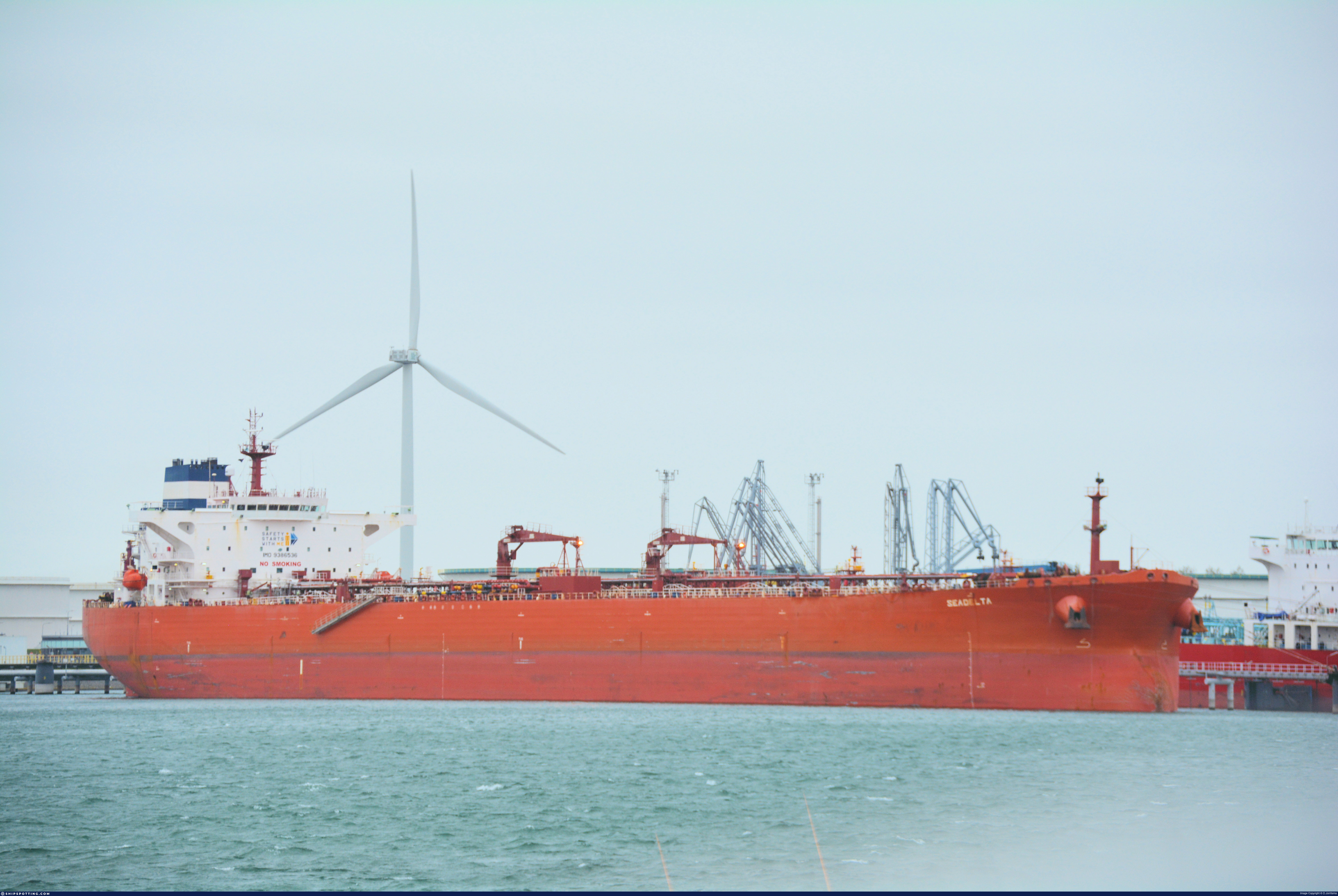
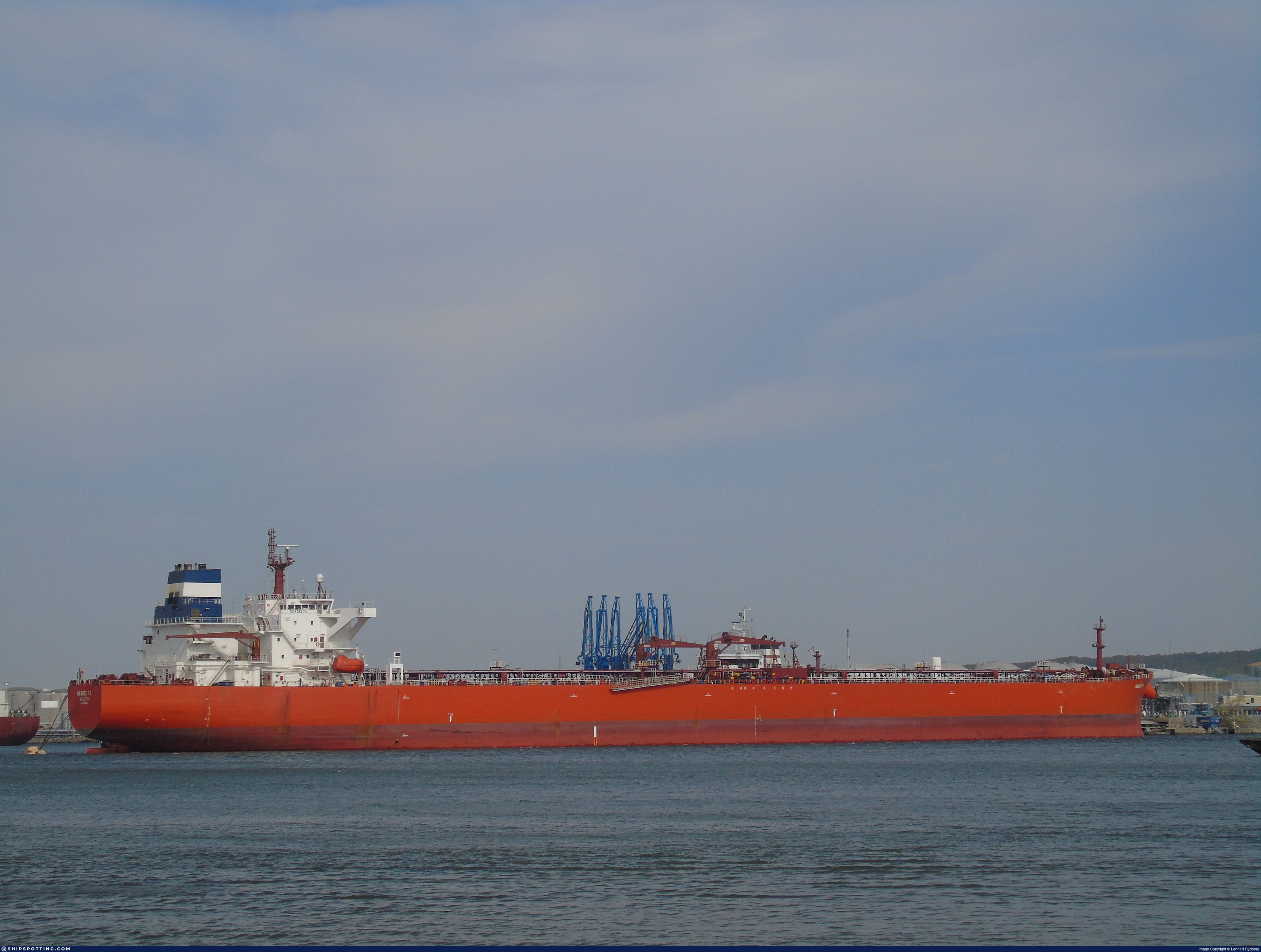
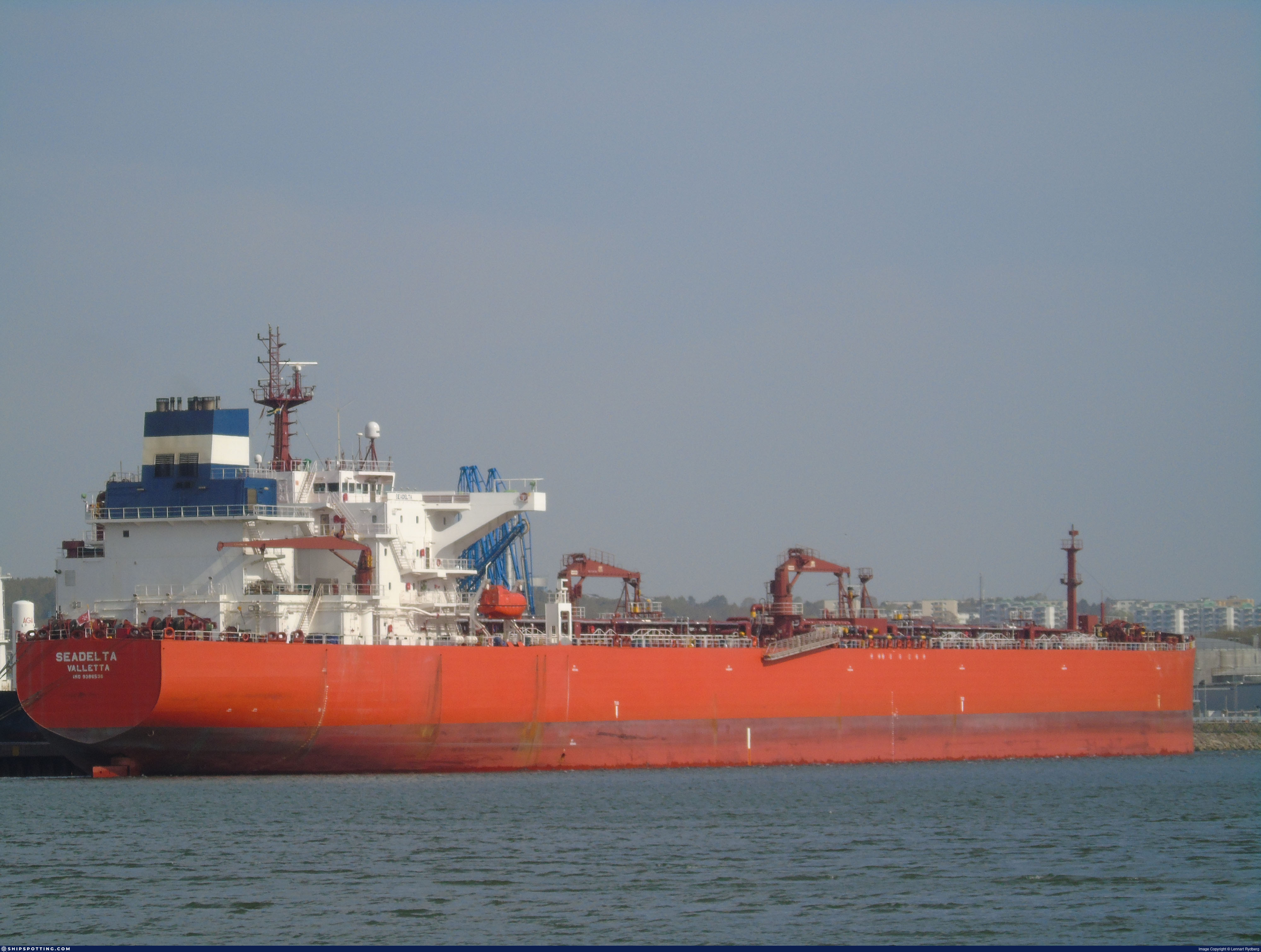
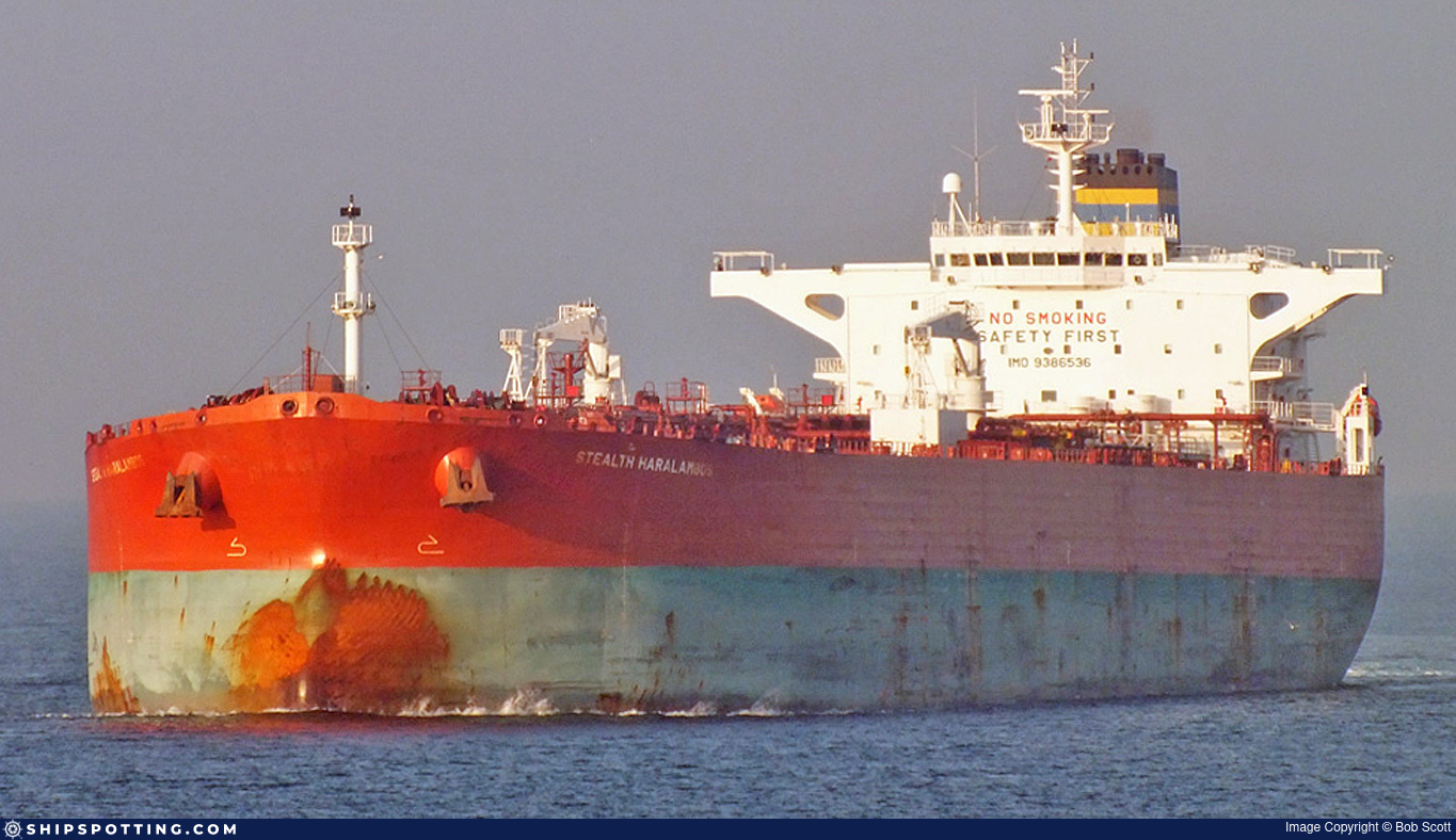
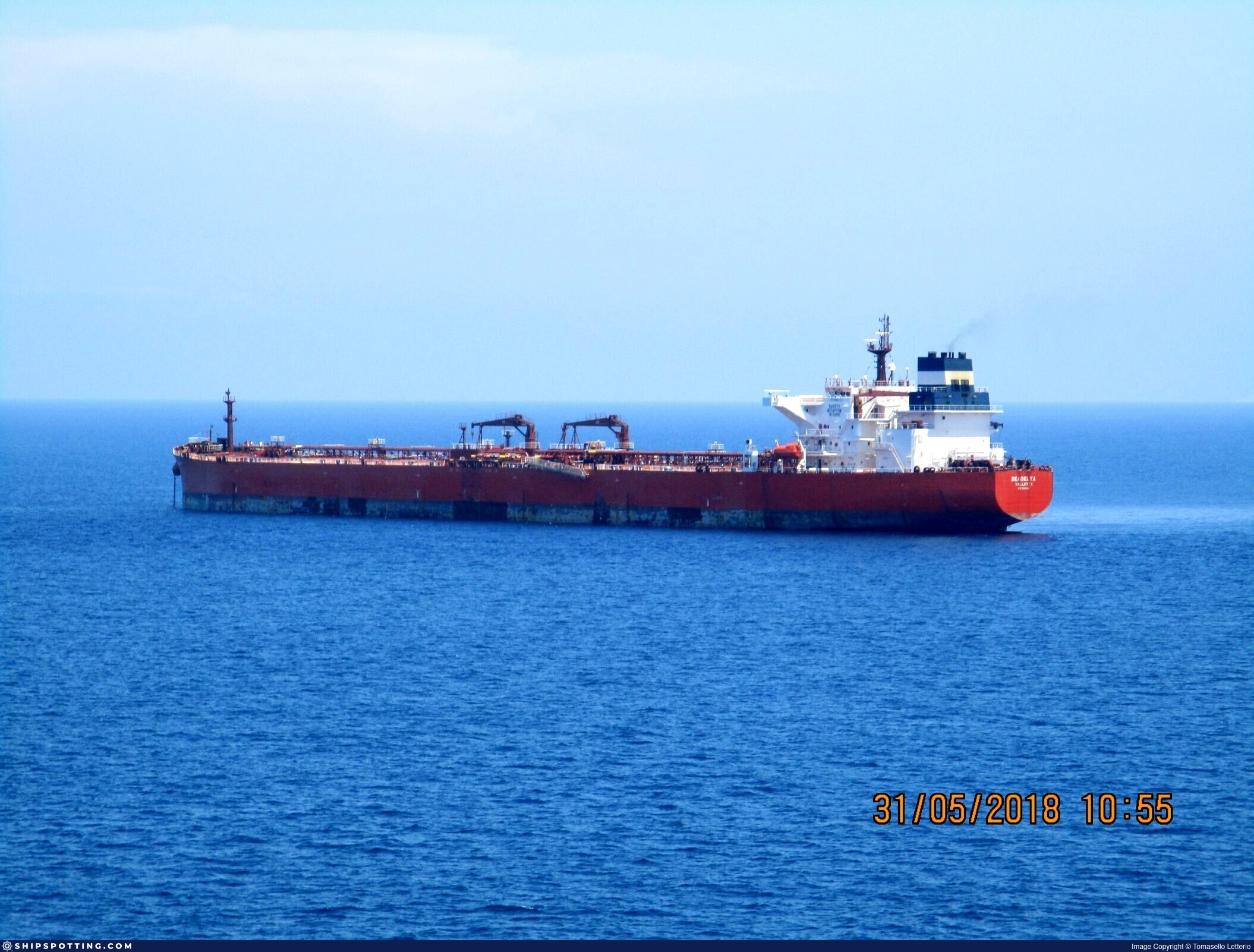
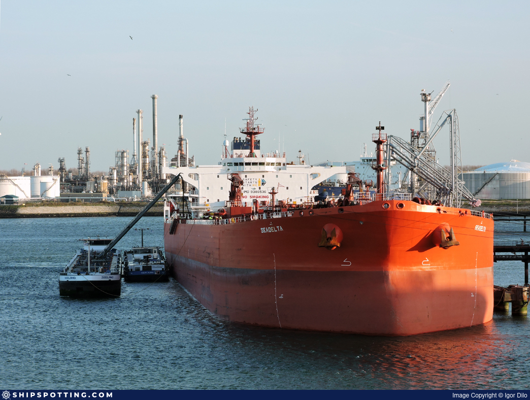
IMO 9386536
Vessel information
Sanctioned by
Company & Ownership
Management & Operations
Classification & Safety
Port State Control (PSC) Inspections
Survey Renewal & Certificates
| Code | Type | Issuer | Issued | Expires |
|---|---|---|---|---|
| 508 | Load Line | Lloyd`s Register (LR) (160) | 01/05/2024 | 19/01/2029 |
| 507 | International Sewage Pollution Prevention | Lloyd`s Register (LR) (160) | 01/05/2024 | 19/01/2029 |
Programs & Notes
EU Russia Sanctions – Shadow Fleet | SEMA (Canada) — vessel designations | The Russia (Sanctions) (EU Exit) Regulations 2019
DateOfListing: 2025-05-21 || DateDesignated: 2025-05-20 | Shipping sanctions: (see “Other information”) | Shipping sanctions: a specified ship is prohibited from being provided with access to or having its master or pilot cause it to enter a port in the UK, may have its registration on the UK Ship Register terminated, and a master or pilot of a specified ship may be given a port barring direction, a detention direction, and a port entry direction or a movement direction. | IMO 9386536 (“SPRING FORTUNE”) is involved in activity whose object or effect is to destabilise Ukraine or undermine or threaten the territorial integrity, sovereignty or independence of Ukraine or to obtain a benefit from or support the Government of Russia. Namely, IMO 9386536 is involved in carrying oil or oil products that originated in Russia from Russia to a third country.
Vessel Changes
 🔄 Owner
 🔄 Owner
 ✏️ Name
AIS Events
50 events detected • 8 zones • Last: Jun 3, 2026
- Zone: discovered_020
- Duration: 1h 1m
- Data Points: 3 AIS positions
- Period: 2026-06-03T05:44:35+00:00 to 2026-06-03T06:45:56+00:00
Show Raw Evidence JSON
{
    "zone_id": "discovered_020",
    "zone_name": "Eastern Mediterranean Monitoring Zone",
    "dwell_minutes": 61.39999999999999857891452847979962825775146484375,
    "points_in_zone": 3,
    "first_point": {
        "ts": "2026-06-03T05:44:35+00:00",
        "lat": 30.954738299999998929479261278174817562103271484375,
        "lon": 32.31297829999999748906702734529972076416015625
    },
    "last_point": {
        "ts": "2026-06-03T06:45:56+00:00",
        "lat": 30.81515999999999877445588936097919940948486328125,
        "lon": 32.31808670000000205391188501380383968353271484375
    }
}- Zone: Port Said/Suez Approach
- Duration: 1h 1m
- Data Points: 3 AIS positions
- Period: 2026-06-03T05:44:35+00:00 to 2026-06-03T06:45:56+00:00
Show Raw Evidence JSON
{
    "zone_id": "osint_port_said",
    "zone_name": "Port Said\/Suez Approach",
    "dwell_minutes": 61.39999999999999857891452847979962825775146484375,
    "points_in_zone": 3,
    "first_point": {
        "ts": "2026-06-03T05:44:35+00:00",
        "lat": 30.954738299999998929479261278174817562103271484375,
        "lon": 32.31297829999999748906702734529972076416015625
    },
    "last_point": {
        "ts": "2026-06-03T06:45:56+00:00",
        "lat": 30.81515999999999877445588936097919940948486328125,
        "lon": 32.31808670000000205391188501380383968353271484375
    }
}- Zone: discovered_020
- Duration: 4h 15m
- Data Points: 4 AIS positions
- Period: 2026-06-03T02:30:50+00:00 to 2026-06-03T06:45:56+00:00
Show Raw Evidence JSON
{
    "zone_id": "discovered_020",
    "zone_name": "Eastern Mediterranean Monitoring Zone",
    "dwell_minutes": 255.099999999999994315658113919198513031005859375,
    "points_in_zone": 4,
    "first_point": {
        "ts": "2026-06-03T02:30:50+00:00",
        "lat": 31.425766700000000497539076604880392551422119140625,
        "lon": 32.40240000000000009094947017729282379150390625
    },
    "last_point": {
        "ts": "2026-06-03T06:45:56+00:00",
        "lat": 30.81515999999999877445588936097919940948486328125,
        "lon": 32.31808670000000205391188501380383968353271484375
    }
}- Zone: discovered_020
- Duration: 3h 30m
- Data Points: 2 AIS positions
- Period: 2026-06-02T23:00:25+00:00 to 2026-06-03T02:30:50+00:00
Show Raw Evidence JSON
{
    "zone_id": "discovered_020",
    "zone_name": "Eastern Mediterranean Monitoring Zone",
    "dwell_minutes": 210.400000000000005684341886080801486968994140625,
    "points_in_zone": 2,
    "first_point": {
        "ts": "2026-06-02T23:00:25+00:00",
        "lat": 31.458449999999999135980033315718173980712890625,
        "lon": 32.30418329999999826895873411558568477630615234375
    },
    "last_point": {
        "ts": "2026-06-03T02:30:50+00:00",
        "lat": 31.425766700000000497539076604880392551422119140625,
        "lon": 32.40240000000000009094947017729282379150390625
    }
}- Zone: discovered_020
- Duration: 4h 18m
- Data Points: 8 AIS positions
- Period: 2026-06-02T22:12:23+00:00 to 2026-06-03T02:30:50+00:00
Show Raw Evidence JSON
{
    "zone_id": "discovered_020",
    "zone_name": "Eastern Mediterranean Monitoring Zone",
    "dwell_minutes": 258.3999999999999772626324556767940521240234375,
    "points_in_zone": 8,
    "first_point": {
        "ts": "2026-06-02T22:12:23+00:00",
        "lat": 31.4585000000000007958078640513122081756591796875,
        "lon": 32.30416670000000323170752380974590778350830078125
    },
    "last_point": {
        "ts": "2026-06-03T02:30:50+00:00",
        "lat": 31.425766700000000497539076604880392551422119140625,
        "lon": 32.40240000000000009094947017729282379150390625
    }
}- Zone: discovered_020
- Duration: 4h 33m
- Data Points: 9 AIS positions
- Period: 2026-06-02T21:57:23+00:00 to 2026-06-03T02:30:50+00:00
Show Raw Evidence JSON
{
    "zone_id": "discovered_020",
    "zone_name": "Eastern Mediterranean Monitoring Zone",
    "dwell_minutes": 273.3999999999999772626324556767940521240234375,
    "points_in_zone": 9,
    "first_point": {
        "ts": "2026-06-02T21:57:23+00:00",
        "lat": 31.458449999999999135980033315718173980712890625,
        "lon": 32.30418329999999826895873411558568477630615234375
    },
    "last_point": {
        "ts": "2026-06-03T02:30:50+00:00",
        "lat": 31.425766700000000497539076604880392551422119140625,
        "lon": 32.40240000000000009094947017729282379150390625
    }
}- Duration: 2h 58m
- Radius: 25 meters
- Data Points: 15 AIS positions
- Centroid: 31.4584, 32.3042
- Zone: discovered_020
Show Raw Evidence JSON
{
    "radius_m": 25,
    "duration_minutes": 178.900000000000005684341886080801486968994140625,
    "points": 15,
    "centroid": {
        "lat": 31.4584255533333276844132342375814914703369140625,
        "lon": 32.3041811066666610940956161357462406158447265625
    },
    "bbox": {
        "min_lat": 31.458200000000001494981916039250791072845458984375,
        "min_lon": 32.30413329999999660913090337999165058135986328125,
        "max_lat": 31.458633299999998911289367242716252803802490234375,
        "max_lon": 32.30423329999999992878656485117971897125244140625
    },
    "zone_id": "discovered_020"
}- Zone: discovered_020
- Duration: 6h 29m
- Data Points: 16 AIS positions
- Period: 2026-06-02T20:01:31+00:00 to 2026-06-03T02:30:50+00:00
Show Raw Evidence JSON
{
    "zone_id": "discovered_020",
    "zone_name": "Eastern Mediterranean Monitoring Zone",
    "dwell_minutes": 389.30000000000001136868377216160297393798828125,
    "points_in_zone": 16,
    "first_point": {
        "ts": "2026-06-02T20:01:31+00:00",
        "lat": 31.458633299999998911289367242716252803802490234375,
        "lon": 32.30423329999999992878656485117971897125244140625
    },
    "last_point": {
        "ts": "2026-06-03T02:30:50+00:00",
        "lat": 31.425766700000000497539076604880392551422119140625,
        "lon": 32.40240000000000009094947017729282379150390625
    }
}- Duration: 3h 56m
- Radius: 124 meters
- Data Points: 32 AIS positions
- Centroid: 31.4588, 32.3044
- Zone: discovered_020
Show Raw Evidence JSON
{
    "radius_m": 124.099999999999994315658113919198513031005859375,
    "duration_minutes": 236.19999999999998863131622783839702606201171875,
    "points": 32,
    "centroid": {
        "lat": 31.45882656562499590791048831306397914886474609375,
        "lon": 32.30437500312499565779944532550871372222900390625
    },
    "bbox": {
        "min_lat": 31.458200000000001494981916039250791072845458984375,
        "min_lon": 32.30413329999999660913090337999165058135986328125,
        "max_lat": 31.45971670000000131039996631443500518798828125,
        "max_lon": 32.305166700000000901127350516617298126220703125
    },
    "zone_id": "discovered_020"
}- Zone: discovered_020
- Duration: 3h 56m
- Data Points: 32 AIS positions
- Period: 2026-06-02T19:04:15+00:00 to 2026-06-02T23:00:25+00:00
Show Raw Evidence JSON
{
    "zone_id": "discovered_020",
    "zone_name": "Eastern Mediterranean Monitoring Zone",
    "dwell_minutes": 236.19999999999998863131622783839702606201171875,
    "points_in_zone": 32,
    "first_point": {
        "ts": "2026-06-02T19:04:15+00:00",
        "lat": 31.45971670000000131039996631443500518798828125,
        "lon": 32.305166700000000901127350516617298126220703125
    },
    "last_point": {
        "ts": "2026-06-02T23:00:25+00:00",
        "lat": 31.458449999999999135980033315718173980712890625,
        "lon": 32.30418329999999826895873411558568477630615234375
    }
}- Duration: 4h 26m
- Radius: 1,182 meters
- Data Points: 36 AIS positions
- Centroid: 31.4586, 32.3039
- Zone: discovered_020
Show Raw Evidence JSON
{
    "radius_m": 1181.90000000000009094947017729282379150390625,
    "duration_minutes": 266.30000000000001136868377216160297393798828125,
    "points": 36,
    "centroid": {
        "lat": 31.45855694999999485617081518284976482391357421875,
        "lon": 32.30386203611110573774567455984652042388916015625
    },
    "bbox": {
        "min_lat": 31.453316699999998462544681387953460216522216796875,
        "min_lon": 32.29303329999999760957507533021271228790283203125,
        "max_lat": 31.45971670000000131039996631443500518798828125,
        "max_lon": 32.30518330000000304380591842345893383026123046875
    },
    "zone_id": "discovered_020"
}- Zone: discovered_020
- Duration: 4h 57m
- Data Points: 42 AIS positions
- Period: 2026-06-02T18:02:53+00:00 to 2026-06-02T23:00:25+00:00
Show Raw Evidence JSON
{
    "zone_id": "discovered_020",
    "zone_name": "Eastern Mediterranean Monitoring Zone",
    "dwell_minutes": 297.5,
    "points_in_zone": 42,
    "first_point": {
        "ts": "2026-06-02T18:02:53+00:00",
        "lat": 31.469733300000001463558874092996120452880859375,
        "lon": 32.2619667000000021062078303657472133636474609375
    },
    "last_point": {
        "ts": "2026-06-02T23:00:25+00:00",
        "lat": 31.458449999999999135980033315718173980712890625,
        "lon": 32.30418329999999826895873411558568477630615234375
    }
}- Zone: discovered_020
- Duration: 5h 59m
- Data Points: 63 AIS positions
- Period: 2026-06-02T17:01:07+00:00 to 2026-06-02T23:00:25+00:00
Show Raw Evidence JSON
{
    "zone_id": "discovered_020",
    "zone_name": "Eastern Mediterranean Monitoring Zone",
    "dwell_minutes": 359.30000000000001136868377216160297393798828125,
    "points_in_zone": 63,
    "first_point": {
        "ts": "2026-06-02T17:01:07+00:00",
        "lat": 31.5500100000000003319655661471188068389892578125,
        "lon": 32.175780000000003155946615152060985565185546875
    },
    "last_point": {
        "ts": "2026-06-02T23:00:25+00:00",
        "lat": 31.458449999999999135980033315718173980712890625,
        "lon": 32.30418329999999826895873411558568477630615234375
    }
}- Zone: discovered_020
- Duration: 6h 6m
- Data Points: 65 AIS positions
- Period: 2026-06-02T16:53:28+00:00 to 2026-06-02T23:00:25+00:00
Show Raw Evidence JSON
{
    "zone_id": "discovered_020",
    "zone_name": "Eastern Mediterranean Monitoring Zone",
    "dwell_minutes": 366.8999999999999772626324556767940521240234375,
    "points_in_zone": 65,
    "first_point": {
        "ts": "2026-06-02T16:53:28+00:00",
        "lat": 31.565863300000000180034476215951144695281982421875,
        "lon": 32.15668670000000162190190167166292667388916015625
    },
    "last_point": {
        "ts": "2026-06-02T23:00:25+00:00",
        "lat": 31.458449999999999135980033315718173980712890625,
        "lon": 32.30418329999999826895873411558568477630615234375
    }
}- Minimum Distance: 37 meters
- Average Distance: 127 meters
- Duration: 38 minutes
- Period: 2026-06-02T16:12:40+00:00 to 2026-06-02T16:50:39+00:00
- Vessel A Avg Speed: 0.2 knots
- Vessel B Avg Speed: 0.0 knots
- Zone: Eastern Mediterranean Surveillance Zone
Confidence Analysis
Moderate-confidence STS candidate. Two tankers (SPRING FORTUNE and GAZ SERENITY) maintained close proximity (min 37m, avg 127m) for 38 minutes. Both vessels were slow-moving (avg speeds 0.2 and 0.0 knots). The stable separation distance suggests deliberate parallel positioning typical of cargo transfer. Event occurred in Eastern Mediterranean Surveillance Zone, a known STS activity area.
View scoring breakdown
| Factor | Score | Detail |
|---|---|---|
| Distance Tightness | 25/25 | Min distance 37m, avg 127m |
| Duration | 5/25 | Duration 38 minutes |
| Speed Stability | 20/20 | both nearly stationary; very stable speeds |
| Distance Consistency | 12/15 | Distance variance ±47m |
| Isolation | 5/10 | Isolation data not available |
| Context | 5/5 | In monitored zone: Eastern Mediterranean Surveillance Zone |
🛰️ Satellite Corroboration
No satellite imagery for this time/location
No Sentinel-1 scenes covering AOI and time window
Show Raw Evidence JSON
{
    "vessel_a": {
        "mmsi": 273277180,
        "imo": 9386536,
        "name": "SPRING FORTUNE",
        "flag": "RUSSIA"
    },
    "vessel_b": {
        "mmsi": 372961000,
        "imo": 9448499,
        "name": "GAZ SERENITY",
        "flag": "PANAMA"
    },
    "min_distance_m": 36.7999999999999971578290569595992565155029296875,
    "avg_distance_m": 127.099999999999994315658113919198513031005859375,
    "distance_consistency_m": 47.10000000000000142108547152020037174224853515625,
    "duration_minutes": 38,
    "overlap_duration_s": 2279,
    "speed_a_avg": 0.200000000000000011102230246251565404236316680908203125,
    "speed_a_std": 0.13000000000000000444089209850062616169452667236328125,
    "speed_b_avg": 0,
    "speed_b_std": 0,
    "speed_summary": {
        "vessel_a": {
            "avg_sog": 0.200000000000000011102230246251565404236316680908203125,
            "max_sog": 0.40000000000000002220446049250313080847263336181640625
        },
        "vessel_b": {
            "avg_sog": 0,
            "max_sog": 0
        }
    },
    "time_window": {
        "start": "2026-06-02T16:12:40+00:00",
        "end": "2026-06-02T16:50:39+00:00"
    },
    "points_count": {
        "vessel_a": 7,
        "vessel_b": 7
    },
    "zone_id": "discovered_138",
    "zone_name": "Eastern Mediterranean Surveillance Zone",
    "score": {
        "value": 72,
        "components": {
            "distance_tightness": {
                "score": 25,
                "max": 25,
                "detail": "Min distance 37m, avg 127m"
            },
            "duration": {
                "score": 5,
                "max": 25,
                "detail": "Duration 38 minutes"
            },
            "speed_stability": {
                "score": 20,
                "max": 20,
                "detail": "both nearly stationary; very stable speeds"
            },
            "distance_consistency": {
                "score": 12,
                "max": 15,
                "detail": "Distance variance \u00b147m"
            },
            "isolation": {
                "score": 5,
                "max": 10,
                "detail": "Isolation data not available"
            },
            "context": {
                "score": 5,
                "max": 5,
                "detail": "In monitored zone: Eastern Mediterranean Surveillance Zone"
            }
        },
        "summary": "Moderate-confidence STS candidate. Two tankers (SPRING FORTUNE and GAZ SERENITY) maintained close proximity (min 37m, avg 127m) for 38 minutes. Both vessels were slow-moving (avg speeds 0.2 and 0.0 knots). The stable separation distance suggests deliberate parallel positioning typical of cargo transfer. Event occurred in Eastern Mediterranean Surveillance Zone, a known STS activity area."
    },
    "sar": {
        "status": "not_found",
        "centroid": {
            "lat": 31.717289799999999644342096871696412563323974609375,
            "lon": 35.99887439999999827477950020693242549896240234375
        },
        "time_window": {
            "start_ts": "2026-06-02T16:12:40+00:00",
            "end_ts": "2026-06-02T16:50:39+00:00"
        },
        "searched_at": "2026-06-02T23:45:13.211284+00:00",
        "notes": "No Sentinel-1 scenes covering AOI and time window"
    }
}- Minimum Distance: 35 meters
- Average Distance: 124 meters
- Duration: 38 minutes
- Period: 2026-06-02T16:12:40+00:00 to 2026-06-02T16:50:39+00:00
- Vessel A Avg Speed: 0.2 knots
- Vessel B Avg Speed: 0.2 knots
- Zone: Eastern Mediterranean Surveillance Zone
Confidence Analysis
Moderate-confidence STS candidate. Two tankers (SPRING FORTUNE and SEAGAS MAJOR) maintained close proximity (min 35m, avg 124m) for 38 minutes. Both vessels were slow-moving (avg speeds 0.2 and 0.2 knots). The stable separation distance suggests deliberate parallel positioning typical of cargo transfer. Event occurred in Eastern Mediterranean Surveillance Zone, a known STS activity area.
View scoring breakdown
| Factor | Score | Detail |
|---|---|---|
| Distance Tightness | 25/25 | Min distance 35m, avg 124m |
| Duration | 5/25 | Duration 38 minutes |
| Speed Stability | 20/20 | both nearly stationary; very stable speeds |
| Distance Consistency | 12/15 | Distance variance ±48m |
| Isolation | 5/10 | Isolation data not available |
| Context | 5/5 | In monitored zone: Eastern Mediterranean Surveillance Zone |
🛰️ Satellite Corroboration
No satellite imagery for this time/location
No Sentinel-1 scenes covering AOI and time window
Show Raw Evidence JSON
{
    "vessel_a": {
        "mmsi": 273277180,
        "imo": 9386536,
        "name": "SPRING FORTUNE",
        "flag": "RUSSIA"
    },
    "vessel_b": {
        "mmsi": 636016188,
        "imo": 9135793,
        "name": "SEAGAS MAJOR",
        "flag": "LIBERIA"
    },
    "min_distance_m": 35.2999999999999971578290569595992565155029296875,
    "avg_distance_m": 124.2999999999999971578290569595992565155029296875,
    "distance_consistency_m": 48.2999999999999971578290569595992565155029296875,
    "duration_minutes": 38,
    "overlap_duration_s": 2279,
    "speed_a_avg": 0.200000000000000011102230246251565404236316680908203125,
    "speed_a_std": 0.13000000000000000444089209850062616169452667236328125,
    "speed_b_avg": 0.1700000000000000122124532708767219446599483489990234375,
    "speed_b_std": 0.1700000000000000122124532708767219446599483489990234375,
    "speed_summary": {
        "vessel_a": {
            "avg_sog": 0.200000000000000011102230246251565404236316680908203125,
            "max_sog": 0.40000000000000002220446049250313080847263336181640625
        },
        "vessel_b": {
            "avg_sog": 0.1700000000000000122124532708767219446599483489990234375,
            "max_sog": 0.40000000000000002220446049250313080847263336181640625
        }
    },
    "time_window": {
        "start": "2026-06-02T16:12:40+00:00",
        "end": "2026-06-02T16:50:39+00:00"
    },
    "points_count": {
        "vessel_a": 7,
        "vessel_b": 7
    },
    "zone_id": "discovered_138",
    "zone_name": "Eastern Mediterranean Surveillance Zone",
    "score": {
        "value": 72,
        "components": {
            "distance_tightness": {
                "score": 25,
                "max": 25,
                "detail": "Min distance 35m, avg 124m"
            },
            "duration": {
                "score": 5,
                "max": 25,
                "detail": "Duration 38 minutes"
            },
            "speed_stability": {
                "score": 20,
                "max": 20,
                "detail": "both nearly stationary; very stable speeds"
            },
            "distance_consistency": {
                "score": 12,
                "max": 15,
                "detail": "Distance variance \u00b148m"
            },
            "isolation": {
                "score": 5,
                "max": 10,
                "detail": "Isolation data not available"
            },
            "context": {
                "score": 5,
                "max": 5,
                "detail": "In monitored zone: Eastern Mediterranean Surveillance Zone"
            }
        },
        "summary": "Moderate-confidence STS candidate. Two tankers (SPRING FORTUNE and SEAGAS MAJOR) maintained close proximity (min 35m, avg 124m) for 38 minutes. Both vessels were slow-moving (avg speeds 0.2 and 0.2 knots). The stable separation distance suggests deliberate parallel positioning typical of cargo transfer. Event occurred in Eastern Mediterranean Surveillance Zone, a known STS activity area."
    },
    "sar": {
        "status": "not_found",
        "centroid": {
            "lat": 31.717303799999999824876795173622667789459228515625,
            "lon": 35.99885760000000090030880528502166271209716796875
        },
        "time_window": {
            "start_ts": "2026-06-02T16:12:40+00:00",
            "end_ts": "2026-06-02T16:50:39+00:00"
        },
        "searched_at": "2026-06-02T23:45:10.107311+00:00",
        "notes": "No Sentinel-1 scenes covering AOI and time window"
    }
}- Minimum Distance: 36 meters
- Average Distance: 127 meters
- Duration: 38 minutes
- Period: 2026-06-02T16:12:40+00:00 to 2026-06-02T16:50:39+00:00
- Vessel A Avg Speed: 0.2 knots
- Vessel B Avg Speed: 0.0 knots
- Zone: Eastern Mediterranean Surveillance Zone
Confidence Analysis
Moderate-confidence STS candidate. Two tankers (SPRING FORTUNE and THALIA) maintained close proximity (min 36m, avg 127m) for 38 minutes. Both vessels were slow-moving (avg speeds 0.2 and 0.0 knots). The stable separation distance suggests deliberate parallel positioning typical of cargo transfer. Event occurred in Eastern Mediterranean Surveillance Zone, a known STS activity area.
View scoring breakdown
| Factor | Score | Detail |
|---|---|---|
| Distance Tightness | 25/25 | Min distance 36m, avg 127m |
| Duration | 5/25 | Duration 38 minutes |
| Speed Stability | 20/20 | both nearly stationary; very stable speeds |
| Distance Consistency | 12/15 | Distance variance ±47m |
| Isolation | 5/10 | Isolation data not available |
| Context | 5/5 | In monitored zone: Eastern Mediterranean Surveillance Zone |
🛰️ Satellite Corroboration
No satellite imagery for this time/location
No Sentinel-1 scenes covering AOI and time window
Show Raw Evidence JSON
{
    "vessel_a": {
        "mmsi": 273277180,
        "imo": 9386536,
        "name": "SPRING FORTUNE",
        "flag": "RUSSIA"
    },
    "vessel_b": {
        "mmsi": 636015372,
        "imo": 9611541,
        "name": "THALIA",
        "flag": "Liberia"
    },
    "min_distance_m": 36.2999999999999971578290569595992565155029296875,
    "avg_distance_m": 126.900000000000005684341886080801486968994140625,
    "distance_consistency_m": 47,
    "duration_minutes": 38,
    "overlap_duration_s": 2279,
    "speed_a_avg": 0.200000000000000011102230246251565404236316680908203125,
    "speed_a_std": 0.13000000000000000444089209850062616169452667236328125,
    "speed_b_avg": 0,
    "speed_b_std": 0,
    "speed_summary": {
        "vessel_a": {
            "avg_sog": 0.200000000000000011102230246251565404236316680908203125,
            "max_sog": 0.40000000000000002220446049250313080847263336181640625
        },
        "vessel_b": {
            "avg_sog": 0,
            "max_sog": 0
        }
    },
    "time_window": {
        "start": "2026-06-02T16:12:40+00:00",
        "end": "2026-06-02T16:50:39+00:00"
    },
    "points_count": {
        "vessel_a": 7,
        "vessel_b": 7
    },
    "zone_id": "discovered_138",
    "zone_name": "Eastern Mediterranean Surveillance Zone",
    "score": {
        "value": 72,
        "components": {
            "distance_tightness": {
                "score": 25,
                "max": 25,
                "detail": "Min distance 36m, avg 127m"
            },
            "duration": {
                "score": 5,
                "max": 25,
                "detail": "Duration 38 minutes"
            },
            "speed_stability": {
                "score": 20,
                "max": 20,
                "detail": "both nearly stationary; very stable speeds"
            },
            "distance_consistency": {
                "score": 12,
                "max": 15,
                "detail": "Distance variance \u00b147m"
            },
            "isolation": {
                "score": 5,
                "max": 10,
                "detail": "Isolation data not available"
            },
            "context": {
                "score": 5,
                "max": 5,
                "detail": "In monitored zone: Eastern Mediterranean Surveillance Zone"
            }
        },
        "summary": "Moderate-confidence STS candidate. Two tankers (SPRING FORTUNE and THALIA) maintained close proximity (min 36m, avg 127m) for 38 minutes. Both vessels were slow-moving (avg speeds 0.2 and 0.0 knots). The stable separation distance suggests deliberate parallel positioning typical of cargo transfer. Event occurred in Eastern Mediterranean Surveillance Zone, a known STS activity area."
    },
    "sar": {
        "status": "not_found",
        "centroid": {
            "lat": 31.71729189999999931615093373693525791168212890625,
            "lon": 35.998874999999998181010596454143524169921875
        },
        "time_window": {
            "start_ts": "2026-06-02T16:12:40+00:00",
            "end_ts": "2026-06-02T16:50:39+00:00"
        },
        "searched_at": "2026-06-02T23:45:07.645845+00:00",
        "notes": "No Sentinel-1 scenes covering AOI and time window"
    }
}- Minimum Distance: 36 meters
- Average Distance: 109 meters
- Duration: 34 minutes
- Period: 2026-06-02T16:21:52+00:00 to 2026-06-02T16:56:32+00:00
- Vessel A Avg Speed: 0.1 knots
- Vessel B Avg Speed: 0.2 knots
- Zone: Eastern Mediterranean Surveillance Zone
Confidence Analysis
Moderate-confidence STS candidate. Two tankers (HORAE and SPRING FORTUNE) maintained close proximity (min 36m, avg 109m) for 35 minutes. Both vessels were slow-moving (avg speeds 0.1 and 0.2 knots). Moderate distance variation observed during the encounter. Event occurred in Eastern Mediterranean Surveillance Zone, a known STS activity area.
View scoring breakdown
| Factor | Score | Detail |
|---|---|---|
| Distance Tightness | 25/25 | Min distance 36m, avg 109m |
| Duration | 5/25 | Duration 35 minutes |
| Speed Stability | 20/20 | both nearly stationary; very stable speeds |
| Distance Consistency | 8/15 | Distance variance ±58m |
| Isolation | 5/10 | Isolation data not available |
| Context | 5/5 | In monitored zone: Eastern Mediterranean Surveillance Zone |
🛰️ Satellite Corroboration
No satellite imagery for this time/location
No Sentinel-1 scenes covering AOI and time window
Show Raw Evidence JSON
{
    "vessel_a": {
        "mmsi": 352179000,
        "imo": 9413004,
        "name": "HORAE",
        "flag": "Panama"
    },
    "vessel_b": {
        "mmsi": 273277180,
        "imo": 9386536,
        "name": "SPRING FORTUNE",
        "flag": "RUSSIA"
    },
    "min_distance_m": 36.39999999999999857891452847979962825775146484375,
    "avg_distance_m": 109.400000000000005684341886080801486968994140625,
    "distance_consistency_m": 58.10000000000000142108547152020037174224853515625,
    "duration_minutes": 34.7000000000000028421709430404007434844970703125,
    "overlap_duration_s": 2080,
    "speed_a_avg": 0.08000000000000000166533453693773481063544750213623046875,
    "speed_a_std": 0.1000000000000000055511151231257827021181583404541015625,
    "speed_b_avg": 0.2200000000000000011102230246251565404236316680908203125,
    "speed_b_std": 0.1499999999999999944488848768742172978818416595458984375,
    "speed_summary": {
        "vessel_a": {
            "avg_sog": 0.08000000000000000166533453693773481063544750213623046875,
            "max_sog": 0.200000000000000011102230246251565404236316680908203125
        },
        "vessel_b": {
            "avg_sog": 0.2200000000000000011102230246251565404236316680908203125,
            "max_sog": 0.40000000000000002220446049250313080847263336181640625
        }
    },
    "time_window": {
        "start": "2026-06-02T16:21:52+00:00",
        "end": "2026-06-02T16:56:32+00:00"
    },
    "points_count": {
        "vessel_a": 4,
        "vessel_b": 4
    },
    "zone_id": "discovered_138",
    "zone_name": "Eastern Mediterranean Surveillance Zone",
    "score": {
        "value": 68,
        "components": {
            "distance_tightness": {
                "score": 25,
                "max": 25,
                "detail": "Min distance 36m, avg 109m"
            },
            "duration": {
                "score": 5,
                "max": 25,
                "detail": "Duration 35 minutes"
            },
            "speed_stability": {
                "score": 20,
                "max": 20,
                "detail": "both nearly stationary; very stable speeds"
            },
            "distance_consistency": {
                "score": 8,
                "max": 15,
                "detail": "Distance variance \u00b158m"
            },
            "isolation": {
                "score": 5,
                "max": 10,
                "detail": "Isolation data not available"
            },
            "context": {
                "score": 5,
                "max": 5,
                "detail": "In monitored zone: Eastern Mediterranean Surveillance Zone"
            }
        },
        "summary": "Moderate-confidence STS candidate. Two tankers (HORAE and SPRING FORTUNE) maintained close proximity (min 36m, avg 109m) for 35 minutes. Both vessels were slow-moving (avg speeds 0.1 and 0.2 knots). Moderate distance variation observed during the encounter. Event occurred in Eastern Mediterranean Surveillance Zone, a known STS activity area."
    },
    "sar": {
        "status": "not_found",
        "centroid": {
            "lat": 31.717238900000001677881300565786659717559814453125,
            "lon": 35.998859699999997019403963349759578704833984375
        },
        "time_window": {
            "start_ts": "2026-06-02T16:12:40+00:00",
            "end_ts": "2026-06-02T16:56:32+00:00"
        },
        "searched_at": "2026-06-02T19:45:08.127559+00:00",
        "notes": "No Sentinel-1 scenes covering AOI and time window"
    }
}- Minimum Distance: 7 meters
- Average Distance: 116 meters
- Duration: 41 minutes
- Period: 2026-06-02T16:15:53+00:00 to 2026-06-02T16:57:04+00:00
- Vessel A Avg Speed: 0.2 knots
- Vessel B Avg Speed: 0.2 knots
- Zone: Eastern Mediterranean Surveillance Zone
Confidence Analysis
Moderate-confidence STS candidate. Two tankers (EASTERLY AS OLIVIA and SPRING FORTUNE) maintained close proximity (min 7m, avg 116m) for 41 minutes. Both vessels were slow-moving (avg speeds 0.2 and 0.2 knots). Moderate distance variation observed during the encounter. Event occurred in Eastern Mediterranean Surveillance Zone, a known STS activity area.
View scoring breakdown
| Factor | Score | Detail |
|---|---|---|
| Distance Tightness | 25/25 | Min distance 7m, avg 116m |
| Duration | 5/25 | Duration 41 minutes |
| Speed Stability | 20/20 | both nearly stationary; very stable speeds |
| Distance Consistency | 8/15 | Distance variance ±68m |
| Isolation | 5/10 | Isolation data not available |
| Context | 5/5 | In monitored zone: Eastern Mediterranean Surveillance Zone |
🛰️ Satellite Corroboration
No satellite imagery for this time/location
No Sentinel-1 scenes covering AOI and time window
Show Raw Evidence JSON
{
    "vessel_a": {
        "mmsi": 538009615,
        "imo": 9340489,
        "name": "EASTERLY AS OLIVIA",
        "flag": "MARSHALL ISLANDS"
    },
    "vessel_b": {
        "mmsi": 273277180,
        "imo": 9386536,
        "name": "SPRING FORTUNE",
        "flag": "RUSSIA"
    },
    "min_distance_m": 7.29999999999999982236431605997495353221893310546875,
    "avg_distance_m": 116.2999999999999971578290569595992565155029296875,
    "distance_consistency_m": 67.7000000000000028421709430404007434844970703125,
    "duration_minutes": 41.2000000000000028421709430404007434844970703125,
    "overlap_duration_s": 2471,
    "speed_a_avg": 0.190000000000000002220446049250313080847263336181640625,
    "speed_a_std": 0.1700000000000000122124532708767219446599483489990234375,
    "speed_b_avg": 0.2300000000000000099920072216264088638126850128173828125,
    "speed_b_std": 0.1000000000000000055511151231257827021181583404541015625,
    "speed_summary": {
        "vessel_a": {
            "avg_sog": 0.190000000000000002220446049250313080847263336181640625,
            "max_sog": 0.5
        },
        "vessel_b": {
            "avg_sog": 0.2300000000000000099920072216264088638126850128173828125,
            "max_sog": 0.299999999999999988897769753748434595763683319091796875
        }
    },
    "time_window": {
        "start": "2026-06-02T16:15:53+00:00",
        "end": "2026-06-02T16:57:04+00:00"
    },
    "points_count": {
        "vessel_a": 8,
        "vessel_b": 8
    },
    "zone_id": "discovered_138",
    "zone_name": "Eastern Mediterranean Surveillance Zone",
    "score": {
        "value": 68,
        "components": {
            "distance_tightness": {
                "score": 25,
                "max": 25,
                "detail": "Min distance 7m, avg 116m"
            },
            "duration": {
                "score": 5,
                "max": 25,
                "detail": "Duration 41 minutes"
            },
            "speed_stability": {
                "score": 20,
                "max": 20,
                "detail": "both nearly stationary; very stable speeds"
            },
            "distance_consistency": {
                "score": 8,
                "max": 15,
                "detail": "Distance variance \u00b168m"
            },
            "isolation": {
                "score": 5,
                "max": 10,
                "detail": "Isolation data not available"
            },
            "context": {
                "score": 5,
                "max": 5,
                "detail": "In monitored zone: Eastern Mediterranean Surveillance Zone"
            }
        },
        "summary": "Moderate-confidence STS candidate. Two tankers (EASTERLY AS OLIVIA and SPRING FORTUNE) maintained close proximity (min 7m, avg 116m) for 41 minutes. Both vessels were slow-moving (avg speeds 0.2 and 0.2 knots). Moderate distance variation observed during the encounter. Event occurred in Eastern Mediterranean Surveillance Zone, a known STS activity area."
    },
    "sar": {
        "status": "not_found",
        "centroid": {
            "lat": 31.71730420000000094660208560526371002197265625,
            "lon": 35.9983193999999997458871803246438503265380859375
        },
        "time_window": {
            "start_ts": "2026-06-02T16:12:40+00:00",
            "end_ts": "2026-06-02T16:57:04+00:00"
        },
        "searched_at": "2026-06-02T19:45:04.963117+00:00",
        "notes": "No Sentinel-1 scenes covering AOI and time window"
    }
}- Minimum Distance: 90 meters
- Average Distance: 147 meters
- Duration: 37 minutes
- Period: 2026-06-02T16:06:56+00:00 to 2026-06-02T16:44:17+00:00
- Vessel A Avg Speed: 0.0 knots
- Vessel B Avg Speed: 0.2 knots
- Zone: Eastern Mediterranean Surveillance Zone
Confidence Analysis
Moderate-confidence STS candidate. Two tankers (NISSOS ANTIMILOS and SPRING FORTUNE) maintained close proximity (min 90m, avg 147m) for 37 minutes. Both vessels were slow-moving (avg speeds 0.0 and 0.2 knots). The stable separation distance suggests deliberate parallel positioning typical of cargo transfer. Event occurred in Eastern Mediterranean Surveillance Zone, a known STS activity area.
View scoring breakdown
| Factor | Score | Detail |
|---|---|---|
| Distance Tightness | 25/25 | Min distance 90m, avg 147m |
| Duration | 5/25 | Duration 37 minutes |
| Speed Stability | 20/20 | both nearly stationary; very stable speeds |
| Distance Consistency | 15/15 | Distance variance ±25m |
| Isolation | 5/10 | Isolation data not available |
| Context | 5/5 | In monitored zone: Eastern Mediterranean Surveillance Zone |
🛰️ Satellite Corroboration
No satellite imagery for this time/location
No Sentinel-1 scenes covering AOI and time window
Show Raw Evidence JSON
{
    "vessel_a": {
        "mmsi": 538008919,
        "imo": 9895226,
        "name": "NISSOS ANTIMILOS",
        "flag": "MARSHALL ISLANDS"
    },
    "vessel_b": {
        "mmsi": 273277180,
        "imo": 9386536,
        "name": "SPRING FORTUNE",
        "flag": "RUSSIA"
    },
    "min_distance_m": 89.5,
    "avg_distance_m": 146.69999999999998863131622783839702606201171875,
    "distance_consistency_m": 25.199999999999999289457264239899814128875732421875,
    "duration_minutes": 37.39999999999999857891452847979962825775146484375,
    "overlap_duration_s": 2241,
    "speed_a_avg": 0,
    "speed_a_std": 0,
    "speed_b_avg": 0.2399999999999999911182158029987476766109466552734375,
    "speed_b_std": 0.11000000000000000055511151231257827021181583404541015625,
    "speed_summary": {
        "vessel_a": {
            "avg_sog": 0,
            "max_sog": 0
        },
        "vessel_b": {
            "avg_sog": 0.2399999999999999911182158029987476766109466552734375,
            "max_sog": 0.40000000000000002220446049250313080847263336181640625
        }
    },
    "time_window": {
        "start": "2026-06-02T16:06:56+00:00",
        "end": "2026-06-02T16:44:17+00:00"
    },
    "points_count": {
        "vessel_a": 9,
        "vessel_b": 9
    },
    "zone_id": "discovered_138",
    "zone_name": "Eastern Mediterranean Surveillance Zone",
    "score": {
        "value": 75,
        "components": {
            "distance_tightness": {
                "score": 25,
                "max": 25,
                "detail": "Min distance 90m, avg 147m"
            },
            "duration": {
                "score": 5,
                "max": 25,
                "detail": "Duration 37 minutes"
            },
            "speed_stability": {
                "score": 20,
                "max": 20,
                "detail": "both nearly stationary; very stable speeds"
            },
            "distance_consistency": {
                "score": 15,
                "max": 15,
                "detail": "Distance variance \u00b125m"
            },
            "isolation": {
                "score": 5,
                "max": 10,
                "detail": "Isolation data not available"
            },
            "context": {
                "score": 5,
                "max": 5,
                "detail": "In monitored zone: Eastern Mediterranean Surveillance Zone"
            }
        },
        "summary": "Moderate-confidence STS candidate. Two tankers (NISSOS ANTIMILOS and SPRING FORTUNE) maintained close proximity (min 90m, avg 147m) for 37 minutes. Both vessels were slow-moving (avg speeds 0.0 and 0.2 knots). The stable separation distance suggests deliberate parallel positioning typical of cargo transfer. Event occurred in Eastern Mediterranean Surveillance Zone, a known STS activity area."
    },
    "sar": {
        "status": "not_found",
        "centroid": {
            "lat": 31.71752120000000019217623048461973667144775390625,
            "lon": 35.99883700000000175123204826377332210540771484375
        },
        "time_window": {
            "start_ts": "2026-06-02T16:06:56+00:00",
            "end_ts": "2026-06-02T16:44:17+00:00"
        },
        "searched_at": "2026-06-02T23:30:01.795425+00:00",
        "notes": "No Sentinel-1 scenes covering AOI and time window"
    }
}- Minimum Distance: 37 meters
- Average Distance: 135 meters
- Duration: 46 minutes
- Period: 2026-06-02T16:06:12+00:00 to 2026-06-02T16:53:07+00:00
- Vessel A Avg Speed: 0.0 knots
- Vessel B Avg Speed: 0.3 knots
- Zone: Eastern Mediterranean Surveillance Zone
Confidence Analysis
Moderate-confidence STS candidate. Two tankers (TRANS FJORD and SPRING FORTUNE) maintained close proximity (min 37m, avg 135m) for 47 minutes. Both vessels were slow-moving (avg speeds 0.0 and 0.3 knots). The stable separation distance suggests deliberate parallel positioning typical of cargo transfer. Event occurred in Eastern Mediterranean Surveillance Zone, a known STS activity area.
View scoring breakdown
| Factor | Score | Detail |
|---|---|---|
| Distance Tightness | 25/25 | Min distance 37m, avg 135m |
| Duration | 10/25 | Duration 47 minutes |
| Speed Stability | 17/20 | both nearly stationary; stable speeds |
| Distance Consistency | 12/15 | Distance variance ±40m |
| Isolation | 5/10 | Isolation data not available |
| Context | 5/5 | In monitored zone: Eastern Mediterranean Surveillance Zone |
🛰️ Satellite Corroboration
No satellite imagery for this time/location
No Sentinel-1 scenes covering AOI and time window
Show Raw Evidence JSON
{
    "vessel_a": {
        "mmsi": 352003272,
        "imo": 9956939,
        "name": "TRANS FJORD",
        "flag": "Panama"
    },
    "vessel_b": {
        "mmsi": 273277180,
        "imo": 9386536,
        "name": "SPRING FORTUNE",
        "flag": "RUSSIA"
    },
    "min_distance_m": 37.10000000000000142108547152020037174224853515625,
    "avg_distance_m": 134.69999999999998863131622783839702606201171875,
    "distance_consistency_m": 39.5,
    "duration_minutes": 46.89999999999999857891452847979962825775146484375,
    "overlap_duration_s": 2815,
    "speed_a_avg": 0,
    "speed_a_std": 0,
    "speed_b_avg": 0.330000000000000015543122344752191565930843353271484375,
    "speed_b_std": 0.4699999999999999733546474089962430298328399658203125,
    "speed_summary": {
        "vessel_a": {
            "avg_sog": 0,
            "max_sog": 0
        },
        "vessel_b": {
            "avg_sog": 0.330000000000000015543122344752191565930843353271484375,
            "max_sog": 1.6999999999999999555910790149937383830547332763671875
        }
    },
    "time_window": {
        "start": "2026-06-02T16:06:12+00:00",
        "end": "2026-06-02T16:53:07+00:00"
    },
    "points_count": {
        "vessel_a": 11,
        "vessel_b": 11
    },
    "zone_id": "discovered_138",
    "zone_name": "Eastern Mediterranean Surveillance Zone",
    "score": {
        "value": 74,
        "components": {
            "distance_tightness": {
                "score": 25,
                "max": 25,
                "detail": "Min distance 37m, avg 135m"
            },
            "duration": {
                "score": 10,
                "max": 25,
                "detail": "Duration 47 minutes"
            },
            "speed_stability": {
                "score": 17,
                "max": 20,
                "detail": "both nearly stationary; stable speeds"
            },
            "distance_consistency": {
                "score": 12,
                "max": 15,
                "detail": "Distance variance \u00b140m"
            },
            "isolation": {
                "score": 5,
                "max": 10,
                "detail": "Isolation data not available"
            },
            "context": {
                "score": 5,
                "max": 5,
                "detail": "In monitored zone: Eastern Mediterranean Surveillance Zone"
            }
        },
        "summary": "Moderate-confidence STS candidate. Two tankers (TRANS FJORD and SPRING FORTUNE) maintained close proximity (min 37m, avg 135m) for 47 minutes. Both vessels were slow-moving (avg speeds 0.0 and 0.3 knots). The stable separation distance suggests deliberate parallel positioning typical of cargo transfer. Event occurred in Eastern Mediterranean Surveillance Zone, a known STS activity area."
    },
    "sar": {
        "status": "not_found",
        "centroid": {
            "lat": 31.7173939999999987549017532728612422943115234375,
            "lon": 35.9989321999999987156115821562707424163818359375
        },
        "time_window": {
            "start_ts": "2026-06-02T16:06:12+00:00",
            "end_ts": "2026-06-02T16:53:07+00:00"
        },
        "searched_at": "2026-06-02T23:30:12.804590+00:00",
        "notes": "No Sentinel-1 scenes covering AOI and time window"
    }
}- Minimum Distance: 35 meters
- Average Distance: 123 meters
- Duration: 56 minutes
- Period: 2026-06-02T15:56:43+00:00 to 2026-06-02T16:53:28+00:00
- Vessel A Avg Speed: 0.0 knots
- Vessel B Avg Speed: 0.6 knots
- Zone: Eastern Mediterranean Surveillance Zone
Confidence Analysis
Moderate-confidence STS candidate. Two tankers (DENVER and SPRING FORTUNE) maintained close proximity (min 35m, avg 123m) for 57 minutes. Both vessels were slow-moving (avg speeds 0.0 and 0.6 knots). The stable separation distance suggests deliberate parallel positioning typical of cargo transfer. Event occurred in Eastern Mediterranean Surveillance Zone, a known STS activity area.
View scoring breakdown
| Factor | Score | Detail |
|---|---|---|
| Distance Tightness | 25/25 | Min distance 35m, avg 123m |
| Duration | 10/25 | Duration 57 minutes |
| Speed Stability | 12/20 | both very slow; somewhat variable speeds |
| Distance Consistency | 12/15 | Distance variance ±43m |
| Isolation | 5/10 | Isolation data not available |
| Context | 5/5 | In monitored zone: Eastern Mediterranean Surveillance Zone |
🛰️ Satellite Corroboration
No satellite imagery for this time/location
No Sentinel-1 scenes covering AOI and time window
Show Raw Evidence JSON
{
    "vessel_a": {
        "mmsi": 667001964,
        "imo": 9382712,
        "name": "DENVER",
        "flag": "SIERRA LEONE"
    },
    "vessel_b": {
        "mmsi": 273277180,
        "imo": 9386536,
        "name": "SPRING FORTUNE",
        "flag": "RUSSIA"
    },
    "min_distance_m": 35.2000000000000028421709430404007434844970703125,
    "avg_distance_m": 123.400000000000005684341886080801486968994140625,
    "distance_consistency_m": 43.10000000000000142108547152020037174224853515625,
    "duration_minutes": 56.7999999999999971578290569595992565155029296875,
    "overlap_duration_s": 3405,
    "speed_a_avg": 0.01000000000000000020816681711721685132943093776702880859375,
    "speed_a_std": 0.040000000000000000832667268468867405317723751068115234375,
    "speed_b_avg": 0.58999999999999996891375531049561686813831329345703125,
    "speed_b_std": 0.7600000000000000088817841970012523233890533447265625,
    "speed_summary": {
        "vessel_a": {
            "avg_sog": 0.01000000000000000020816681711721685132943093776702880859375,
            "max_sog": 0.1000000000000000055511151231257827021181583404541015625
        },
        "vessel_b": {
            "avg_sog": 0.58999999999999996891375531049561686813831329345703125,
            "max_sog": 1.6999999999999999555910790149937383830547332763671875
        }
    },
    "time_window": {
        "start": "2026-06-02T15:56:43+00:00",
        "end": "2026-06-02T16:53:28+00:00"
    },
    "points_count": {
        "vessel_a": 7,
        "vessel_b": 7
    },
    "zone_id": "discovered_138",
    "zone_name": "Eastern Mediterranean Surveillance Zone",
    "score": {
        "value": 69,
        "components": {
            "distance_tightness": {
                "score": 25,
                "max": 25,
                "detail": "Min distance 35m, avg 123m"
            },
            "duration": {
                "score": 10,
                "max": 25,
                "detail": "Duration 57 minutes"
            },
            "speed_stability": {
                "score": 12,
                "max": 20,
                "detail": "both very slow; somewhat variable speeds"
            },
            "distance_consistency": {
                "score": 12,
                "max": 15,
                "detail": "Distance variance \u00b143m"
            },
            "isolation": {
                "score": 5,
                "max": 10,
                "detail": "Isolation data not available"
            },
            "context": {
                "score": 5,
                "max": 5,
                "detail": "In monitored zone: Eastern Mediterranean Surveillance Zone"
            }
        },
        "summary": "Moderate-confidence STS candidate. Two tankers (DENVER and SPRING FORTUNE) maintained close proximity (min 35m, avg 123m) for 57 minutes. Both vessels were slow-moving (avg speeds 0.0 and 0.6 knots). The stable separation distance suggests deliberate parallel positioning typical of cargo transfer. Event occurred in Eastern Mediterranean Surveillance Zone, a known STS activity area."
    },
    "sar": {
        "status": "not_found",
        "centroid": {
            "lat": 31.717285000000000394493326894007623195648193359375,
            "lon": 35.9991258000000016181729733943939208984375
        },
        "time_window": {
            "start_ts": "2026-06-02T15:56:43+00:00",
            "end_ts": "2026-06-02T16:53:28+00:00"
        },
        "searched_at": "2026-06-02T20:00:05.635302+00:00",
        "notes": "No Sentinel-1 scenes covering AOI and time window"
    }
}- Minimum Distance: 37 meters
- Average Distance: 125 meters
- Duration: 54 minutes
- Period: 2026-06-02T15:55:47+00:00 to 2026-06-02T16:50:39+00:00
- Vessel A Avg Speed: 0.3 knots
- Vessel B Avg Speed: 0.0 knots
- Zone: Eastern Mediterranean Surveillance Zone
Confidence Analysis
Moderate-confidence STS candidate. Two tankers (SPRING FORTUNE and GAZ SERENITY) maintained close proximity (min 37m, avg 124m) for 55 minutes. Both vessels were slow-moving (avg speeds 0.3 and 0.0 knots). The stable separation distance suggests deliberate parallel positioning typical of cargo transfer. Event occurred in Eastern Mediterranean Surveillance Zone, a known STS activity area.
View scoring breakdown
| Factor | Score | Detail |
|---|---|---|
| Distance Tightness | 25/25 | Min distance 37m, avg 124m |
| Duration | 10/25 | Duration 55 minutes |
| Speed Stability | 17/20 | both nearly stationary; stable speeds |
| Distance Consistency | 12/15 | Distance variance ±39m |
| Isolation | 5/10 | Isolation data not available |
| Context | 5/5 | In monitored zone: Eastern Mediterranean Surveillance Zone |
🛰️ Satellite Corroboration
No satellite imagery for this time/location
No Sentinel-1 scenes covering AOI and time window
Show Raw Evidence JSON
{
    "vessel_a": {
        "mmsi": 273277180,
        "imo": 9386536,
        "name": "SPRING FORTUNE",
        "flag": "RUSSIA"
    },
    "vessel_b": {
        "mmsi": 372961000,
        "imo": 9448499,
        "name": "GAZ SERENITY",
        "flag": "PANAMA"
    },
    "min_distance_m": 36.7999999999999971578290569595992565155029296875,
    "avg_distance_m": 124.5,
    "distance_consistency_m": 39.2999999999999971578290569595992565155029296875,
    "duration_minutes": 54.89999999999999857891452847979962825775146484375,
    "overlap_duration_s": 3292,
    "speed_a_avg": 0.320000000000000006661338147750939242541790008544921875,
    "speed_a_std": 0.5,
    "speed_b_avg": 0,
    "speed_b_std": 0,
    "speed_summary": {
        "vessel_a": {
            "avg_sog": 0.320000000000000006661338147750939242541790008544921875,
            "max_sog": 1.6999999999999999555910790149937383830547332763671875
        },
        "vessel_b": {
            "avg_sog": 0,
            "max_sog": 0
        }
    },
    "time_window": {
        "start": "2026-06-02T15:55:47+00:00",
        "end": "2026-06-02T16:50:39+00:00"
    },
    "points_count": {
        "vessel_a": 10,
        "vessel_b": 10
    },
    "zone_id": "discovered_138",
    "zone_name": "Eastern Mediterranean Surveillance Zone",
    "score": {
        "value": 74,
        "components": {
            "distance_tightness": {
                "score": 25,
                "max": 25,
                "detail": "Min distance 37m, avg 124m"
            },
            "duration": {
                "score": 10,
                "max": 25,
                "detail": "Duration 55 minutes"
            },
            "speed_stability": {
                "score": 17,
                "max": 20,
                "detail": "both nearly stationary; stable speeds"
            },
            "distance_consistency": {
                "score": 12,
                "max": 15,
                "detail": "Distance variance \u00b139m"
            },
            "isolation": {
                "score": 5,
                "max": 10,
                "detail": "Isolation data not available"
            },
            "context": {
                "score": 5,
                "max": 5,
                "detail": "In monitored zone: Eastern Mediterranean Surveillance Zone"
            }
        },
        "summary": "Moderate-confidence STS candidate. Two tankers (SPRING FORTUNE and GAZ SERENITY) maintained close proximity (min 37m, avg 124m) for 55 minutes. Both vessels were slow-moving (avg speeds 0.3 and 0.0 knots). The stable separation distance suggests deliberate parallel positioning typical of cargo transfer. Event occurred in Eastern Mediterranean Surveillance Zone, a known STS activity area."
    },
    "sar": {
        "status": "not_found",
        "centroid": {
            "lat": 31.717175900000000865475158207118511199951171875,
            "lon": 35.99892779999999703477442380972206592559814453125
        },
        "time_window": {
            "start_ts": "2026-06-02T15:55:47+00:00",
            "end_ts": "2026-06-02T16:50:39+00:00"
        },
        "searched_at": "2026-06-02T19:30:07.206764+00:00",
        "notes": "No Sentinel-1 scenes covering AOI and time window"
    }
}- Minimum Distance: 92 meters
- Average Distance: 129 meters
- Duration: 46 minutes
- Period: 2026-06-02T15:48:49+00:00 to 2026-06-02T16:35:28+00:00
- Vessel A Avg Speed: 0.3 knots
- Vessel B Avg Speed: 0.0 knots
- Zone: Eastern Mediterranean Surveillance Zone
Confidence Analysis
Moderate-confidence STS candidate. Two tankers (SPRING FORTUNE and HIGH FREEDOM) maintained close proximity (min 92m, avg 129m) for 47 minutes. Both vessels were slow-moving (avg speeds 0.3 and 0.0 knots). The stable separation distance suggests deliberate parallel positioning typical of cargo transfer. Event occurred in Eastern Mediterranean Surveillance Zone, a known STS activity area.
View scoring breakdown
| Factor | Score | Detail |
|---|---|---|
| Distance Tightness | 25/25 | Min distance 92m, avg 129m |
| Duration | 10/25 | Duration 47 minutes |
| Speed Stability | 17/20 | both nearly stationary; stable speeds |
| Distance Consistency | 15/15 | Distance variance ±24m |
| Isolation | 5/10 | Isolation data not available |
| Context | 5/5 | In monitored zone: Eastern Mediterranean Surveillance Zone |
🛰️ Satellite Corroboration
No satellite imagery for this time/location
No Sentinel-1 scenes covering AOI and time window
Show Raw Evidence JSON
{
    "vessel_a": {
        "mmsi": 273277180,
        "imo": 9386536,
        "name": "SPRING FORTUNE",
        "flag": "RUSSIA"
    },
    "vessel_b": {
        "mmsi": 636022700,
        "imo": 9674713,
        "name": "HIGH FREEDOM",
        "flag": "Liberia"
    },
    "min_distance_m": 92,
    "avg_distance_m": 128.900000000000005684341886080801486968994140625,
    "distance_consistency_m": 23.60000000000000142108547152020037174224853515625,
    "duration_minutes": 46.60000000000000142108547152020037174224853515625,
    "overlap_duration_s": 2799,
    "speed_a_avg": 0.320000000000000006661338147750939242541790008544921875,
    "speed_a_std": 0.5,
    "speed_b_avg": 0,
    "speed_b_std": 0,
    "speed_summary": {
        "vessel_a": {
            "avg_sog": 0.320000000000000006661338147750939242541790008544921875,
            "max_sog": 1.6999999999999999555910790149937383830547332763671875
        },
        "vessel_b": {
            "avg_sog": 0,
            "max_sog": 0
        }
    },
    "time_window": {
        "start": "2026-06-02T15:48:49+00:00",
        "end": "2026-06-02T16:35:28+00:00"
    },
    "points_count": {
        "vessel_a": 10,
        "vessel_b": 10
    },
    "zone_id": "discovered_138",
    "zone_name": "Eastern Mediterranean Surveillance Zone",
    "score": {
        "value": 77,
        "components": {
            "distance_tightness": {
                "score": 25,
                "max": 25,
                "detail": "Min distance 92m, avg 129m"
            },
            "duration": {
                "score": 10,
                "max": 25,
                "detail": "Duration 47 minutes"
            },
            "speed_stability": {
                "score": 17,
                "max": 20,
                "detail": "both nearly stationary; stable speeds"
            },
            "distance_consistency": {
                "score": 15,
                "max": 15,
                "detail": "Distance variance \u00b124m"
            },
            "isolation": {
                "score": 5,
                "max": 10,
                "detail": "Isolation data not available"
            },
            "context": {
                "score": 5,
                "max": 5,
                "detail": "In monitored zone: Eastern Mediterranean Surveillance Zone"
            }
        },
        "summary": "Moderate-confidence STS candidate. Two tankers (SPRING FORTUNE and HIGH FREEDOM) maintained close proximity (min 92m, avg 129m) for 47 minutes. Both vessels were slow-moving (avg speeds 0.3 and 0.0 knots). The stable separation distance suggests deliberate parallel positioning typical of cargo transfer. Event occurred in Eastern Mediterranean Surveillance Zone, a known STS activity area."
    },
    "sar": {
        "status": "not_found",
        "centroid": {
            "lat": 31.717141500000000320369508699513971805572509765625,
            "lon": 35.99893670000000156505848281085491180419921875
        },
        "time_window": {
            "start_ts": "2026-06-02T15:54:18+00:00",
            "end_ts": "2026-06-02T16:35:28+00:00"
        },
        "searched_at": "2026-06-02T18:45:13.234105+00:00",
        "notes": "No Sentinel-1 scenes covering AOI and time window"
    }
}- Minimum Distance: 33 meters
- Average Distance: 127 meters
- Duration: 1h 2m
- Period: 2026-06-02T15:53:37+00:00 to 2026-06-02T16:55:40+00:00
- Vessel A Avg Speed: 0.1 knots
- Vessel B Avg Speed: 0.4 knots
- Zone: Eastern Mediterranean Surveillance Zone
Confidence Analysis
Moderate-confidence STS candidate. Two tankers (SEAGAS MAJOR and SPRING FORTUNE) maintained close proximity (min 33m, avg 127m) for 62 minutes. Both vessels were slow-moving (avg speeds 0.1 and 0.4 knots). The stable separation distance suggests deliberate parallel positioning typical of cargo transfer. Event occurred in Eastern Mediterranean Surveillance Zone, a known STS activity area.
View scoring breakdown
| Factor | Score | Detail |
|---|---|---|
| Distance Tightness | 25/25 | Min distance 33m, avg 127m |
| Duration | 15/25 | Duration 62 minutes |
| Speed Stability | 14/20 | both nearly stationary; somewhat variable speeds |
| Distance Consistency | 12/15 | Distance variance ±43m |
| Isolation | 5/10 | Isolation data not available |
| Context | 5/5 | In monitored zone: Eastern Mediterranean Surveillance Zone |
🛰️ Satellite Corroboration
No satellite imagery for this time/location
No Sentinel-1 scenes covering AOI and time window
Show Raw Evidence JSON
{
    "vessel_a": {
        "mmsi": 636016188,
        "imo": 9135793,
        "name": "SEAGAS MAJOR",
        "flag": "LIBERIA"
    },
    "vessel_b": {
        "mmsi": 273277180,
        "imo": 9386536,
        "name": "SPRING FORTUNE",
        "flag": "RUSSIA"
    },
    "min_distance_m": 33.2000000000000028421709430404007434844970703125,
    "avg_distance_m": 126.7000000000000028421709430404007434844970703125,
    "distance_consistency_m": 42.7999999999999971578290569595992565155029296875,
    "duration_minutes": 62,
    "overlap_duration_s": 3723,
    "speed_a_avg": 0.13000000000000000444089209850062616169452667236328125,
    "speed_a_std": 0.14000000000000001332267629550187848508358001708984375,
    "speed_b_avg": 0.36999999999999999555910790149937383830547332763671875,
    "speed_b_std": 0.5500000000000000444089209850062616169452667236328125,
    "speed_summary": {
        "vessel_a": {
            "avg_sog": 0.13000000000000000444089209850062616169452667236328125,
            "max_sog": 0.5
        },
        "vessel_b": {
            "avg_sog": 0.36999999999999999555910790149937383830547332763671875,
            "max_sog": 1.6999999999999999555910790149937383830547332763671875
        }
    },
    "time_window": {
        "start": "2026-06-02T15:53:37+00:00",
        "end": "2026-06-02T16:55:40+00:00"
    },
    "points_count": {
        "vessel_a": 15,
        "vessel_b": 15
    },
    "zone_id": "discovered_138",
    "zone_name": "Eastern Mediterranean Surveillance Zone",
    "score": {
        "value": 76,
        "components": {
            "distance_tightness": {
                "score": 25,
                "max": 25,
                "detail": "Min distance 33m, avg 127m"
            },
            "duration": {
                "score": 15,
                "max": 25,
                "detail": "Duration 62 minutes"
            },
            "speed_stability": {
                "score": 14,
                "max": 20,
                "detail": "both nearly stationary; somewhat variable speeds"
            },
            "distance_consistency": {
                "score": 12,
                "max": 15,
                "detail": "Distance variance \u00b143m"
            },
            "isolation": {
                "score": 5,
                "max": 10,
                "detail": "Isolation data not available"
            },
            "context": {
                "score": 5,
                "max": 5,
                "detail": "In monitored zone: Eastern Mediterranean Surveillance Zone"
            }
        },
        "summary": "Moderate-confidence STS candidate. Two tankers (SEAGAS MAJOR and SPRING FORTUNE) maintained close proximity (min 33m, avg 127m) for 62 minutes. Both vessels were slow-moving (avg speeds 0.1 and 0.4 knots). The stable separation distance suggests deliberate parallel positioning typical of cargo transfer. Event occurred in Eastern Mediterranean Surveillance Zone, a known STS activity area."
    },
    "sar": {
        "status": "not_found",
        "centroid": {
            "lat": 31.717056899999999330930222640745341777801513671875,
            "lon": 35.9988656000000020185325411148369312286376953125
        },
        "time_window": {
            "start_ts": "2026-06-02T15:53:37+00:00",
            "end_ts": "2026-06-02T16:55:40+00:00"
        },
        "searched_at": "2026-06-02T17:45:09.715287+00:00",
        "notes": "No Sentinel-1 scenes covering AOI and time window"
    }
}- Minimum Distance: 4 meters
- Average Distance: 97 meters
- Duration: 50 minutes
- Period: 2026-06-02T15:40:46+00:00 to 2026-06-02T16:30:59+00:00
- Vessel A Avg Speed: 0.2 knots
- Vessel B Avg Speed: 0.4 knots
- Zone: Eastern Mediterranean Surveillance Zone
Confidence Analysis
Moderate-confidence STS candidate. Two tankers (AHINOS and SPRING FORTUNE) maintained close proximity (min 4m, avg 97m) for 50 minutes. Both vessels were slow-moving (avg speeds 0.1 and 0.4 knots). Event occurred in Eastern Mediterranean Surveillance Zone, a known STS activity area.
View scoring breakdown
| Factor | Score | Detail |
|---|---|---|
| Distance Tightness | 25/25 | Min distance 4m, avg 97m |
| Duration | 10/25 | Duration 50 minutes |
| Speed Stability | 14/20 | both nearly stationary; somewhat variable speeds |
| Distance Consistency | 5/15 | Distance variance ±109m |
| Isolation | 5/10 | Isolation data not available |
| Context | 5/5 | In monitored zone: Eastern Mediterranean Surveillance Zone |
🛰️ Satellite Corroboration
No satellite imagery for this time/location
No Sentinel-1 scenes covering AOI and time window
Show Raw Evidence JSON
{
    "vessel_a": {
        "mmsi": 636024537,
        "imo": 9328144,
        "name": "AHINOS",
        "flag": "Liberia"
    },
    "vessel_b": {
        "mmsi": 273277180,
        "imo": 9386536,
        "name": "SPRING FORTUNE",
        "flag": "RUSSIA"
    },
    "min_distance_m": 4,
    "avg_distance_m": 96.900000000000005684341886080801486968994140625,
    "distance_consistency_m": 109.099999999999994315658113919198513031005859375,
    "duration_minutes": 50.2000000000000028421709430404007434844970703125,
    "overlap_duration_s": 3013,
    "speed_a_avg": 0.1499999999999999944488848768742172978818416595458984375,
    "speed_a_std": 0.2800000000000000266453525910037569701671600341796875,
    "speed_b_avg": 0.419999999999999984456877655247808434069156646728515625,
    "speed_b_std": 0.64000000000000001332267629550187848508358001708984375,
    "speed_summary": {
        "vessel_a": {
            "avg_sog": 0.1499999999999999944488848768742172978818416595458984375,
            "max_sog": 0.6999999999999999555910790149937383830547332763671875
        },
        "vessel_b": {
            "avg_sog": 0.419999999999999984456877655247808434069156646728515625,
            "max_sog": 1.6999999999999999555910790149937383830547332763671875
        }
    },
    "time_window": {
        "start": "2026-06-02T15:40:46+00:00",
        "end": "2026-06-02T16:30:59+00:00"
    },
    "points_count": {
        "vessel_a": 6,
        "vessel_b": 6
    },
    "zone_id": "discovered_138",
    "zone_name": "Eastern Mediterranean Surveillance Zone",
    "score": {
        "value": 64,
        "components": {
            "distance_tightness": {
                "score": 25,
                "max": 25,
                "detail": "Min distance 4m, avg 97m"
            },
            "duration": {
                "score": 10,
                "max": 25,
                "detail": "Duration 50 minutes"
            },
            "speed_stability": {
                "score": 14,
                "max": 20,
                "detail": "both nearly stationary; somewhat variable speeds"
            },
            "distance_consistency": {
                "score": 5,
                "max": 15,
                "detail": "Distance variance \u00b1109m"
            },
            "isolation": {
                "score": 5,
                "max": 10,
                "detail": "Isolation data not available"
            },
            "context": {
                "score": 5,
                "max": 5,
                "detail": "In monitored zone: Eastern Mediterranean Surveillance Zone"
            }
        },
        "summary": "Moderate-confidence STS candidate. Two tankers (AHINOS and SPRING FORTUNE) maintained close proximity (min 4m, avg 97m) for 50 minutes. Both vessels were slow-moving (avg speeds 0.1 and 0.4 knots). Event occurred in Eastern Mediterranean Surveillance Zone, a known STS activity area."
    },
    "sar": {
        "status": "not_found",
        "centroid": {
            "lat": 31.717285499999999132114680833183228969573974609375,
            "lon": 35.99814380000000113568603410385549068450927734375
        },
        "time_window": {
            "start_ts": "2026-06-02T15:48:49+00:00",
            "end_ts": "2026-06-02T16:30:59+00:00"
        },
        "searched_at": "2026-06-02T19:00:06.709341+00:00",
        "notes": "No Sentinel-1 scenes covering AOI and time window"
    }
}- Minimum Distance: 90 meters
- Average Distance: 142 meters
- Duration: 54 minutes
- Period: 2026-06-02T15:49:55+00:00 to 2026-06-02T16:44:17+00:00
- Vessel A Avg Speed: 0.1 knots
- Vessel B Avg Speed: 0.3 knots
- Zone: Eastern Mediterranean Surveillance Zone
Confidence Analysis
Moderate-confidence STS candidate. Two tankers (NISSOS ANTIMILOS and SPRING FORTUNE) maintained close proximity (min 90m, avg 142m) for 54 minutes. Both vessels were slow-moving (avg speeds 0.1 and 0.3 knots). The stable separation distance suggests deliberate parallel positioning typical of cargo transfer. Event occurred in Eastern Mediterranean Surveillance Zone, a known STS activity area.
View scoring breakdown
| Factor | Score | Detail |
|---|---|---|
| Distance Tightness | 25/25 | Min distance 90m, avg 142m |
| Duration | 10/25 | Duration 54 minutes |
| Speed Stability | 17/20 | both nearly stationary; stable speeds |
| Distance Consistency | 15/15 | Distance variance ±24m |
| Isolation | 5/10 | Isolation data not available |
| Context | 5/5 | In monitored zone: Eastern Mediterranean Surveillance Zone |
Show Raw Evidence JSON
{
    "vessel_a": {
        "mmsi": 538008919,
        "imo": 9895226,
        "name": "NISSOS ANTIMILOS",
        "flag": "MARSHALL ISLANDS"
    },
    "vessel_b": {
        "mmsi": 273277180,
        "imo": 9386536,
        "name": "SPRING FORTUNE",
        "flag": "RUSSIA"
    },
    "min_distance_m": 89.5,
    "avg_distance_m": 142.400000000000005684341886080801486968994140625,
    "distance_consistency_m": 24,
    "duration_minutes": 54.39999999999999857891452847979962825775146484375,
    "overlap_duration_s": 3262,
    "speed_a_avg": 0.1000000000000000055511151231257827021181583404541015625,
    "speed_a_std": 0.35999999999999998667732370449812151491641998291015625,
    "speed_b_avg": 0.320000000000000006661338147750939242541790008544921875,
    "speed_b_std": 0.429999999999999993338661852249060757458209991455078125,
    "speed_summary": {
        "vessel_a": {
            "avg_sog": 0.1000000000000000055511151231257827021181583404541015625,
            "max_sog": 1.3000000000000000444089209850062616169452667236328125
        },
        "vessel_b": {
            "avg_sog": 0.320000000000000006661338147750939242541790008544921875,
            "max_sog": 1.6999999999999999555910790149937383830547332763671875
        }
    },
    "time_window": {
        "start": "2026-06-02T15:49:55+00:00",
        "end": "2026-06-02T16:44:17+00:00"
    },
    "points_count": {
        "vessel_a": 13,
        "vessel_b": 13
    },
    "zone_id": "discovered_138",
    "zone_name": "Eastern Mediterranean Surveillance Zone",
    "score": {
        "value": 77,
        "components": {
            "distance_tightness": {
                "score": 25,
                "max": 25,
                "detail": "Min distance 90m, avg 142m"
            },
            "duration": {
                "score": 10,
                "max": 25,
                "detail": "Duration 54 minutes"
            },
            "speed_stability": {
                "score": 17,
                "max": 20,
                "detail": "both nearly stationary; stable speeds"
            },
            "distance_consistency": {
                "score": 15,
                "max": 15,
                "detail": "Distance variance \u00b124m"
            },
            "isolation": {
                "score": 5,
                "max": 10,
                "detail": "Isolation data not available"
            },
            "context": {
                "score": 5,
                "max": 5,
                "detail": "In monitored zone: Eastern Mediterranean Surveillance Zone"
            }
        },
        "summary": "Moderate-confidence STS candidate. Two tankers (NISSOS ANTIMILOS and SPRING FORTUNE) maintained close proximity (min 90m, avg 142m) for 54 minutes. Both vessels were slow-moving (avg speeds 0.1 and 0.3 knots). The stable separation distance suggests deliberate parallel positioning typical of cargo transfer. Event occurred in Eastern Mediterranean Surveillance Zone, a known STS activity area."
    }
}- Minimum Distance: 91 meters
- Average Distance: 128 meters
- Duration: 33 minutes
- Period: 2026-06-02T15:48:49+00:00 to 2026-06-02T16:22:09+00:00
- Vessel A Avg Speed: 0.3 knots
- Vessel B Avg Speed: 0.0 knots
- Zone: Eastern Mediterranean Surveillance Zone
Confidence Analysis
Moderate-confidence STS candidate. Two tankers (SPRING FORTUNE and DORIN) maintained close proximity (min 91m, avg 128m) for 33 minutes. Both vessels were slow-moving (avg speeds 0.3 and 0.0 knots). The stable separation distance suggests deliberate parallel positioning typical of cargo transfer. Event occurred in Eastern Mediterranean Surveillance Zone, a known STS activity area.
View scoring breakdown
| Factor | Score | Detail |
|---|---|---|
| Distance Tightness | 25/25 | Min distance 91m, avg 128m |
| Duration | 5/25 | Duration 33 minutes |
| Speed Stability | 14/20 | both nearly stationary; somewhat variable speeds |
| Distance Consistency | 15/15 | Distance variance ±25m |
| Isolation | 5/10 | Isolation data not available |
| Context | 5/5 | In monitored zone: Eastern Mediterranean Surveillance Zone |
🛰️ Satellite Corroboration
No satellite imagery for this time/location
No Sentinel-1 scenes covering AOI and time window
Show Raw Evidence JSON
{
    "vessel_a": {
        "mmsi": 273277180,
        "imo": 9386536,
        "name": "SPRING FORTUNE",
        "flag": "RUSSIA"
    },
    "vessel_b": {
        "mmsi": 613414203,
        "imo": 9290828,
        "name": "DORIN",
        "flag": "CAMEROON"
    },
    "min_distance_m": 91.2000000000000028421709430404007434844970703125,
    "avg_distance_m": 127.7999999999999971578290569595992565155029296875,
    "distance_consistency_m": 24.800000000000000710542735760100185871124267578125,
    "duration_minutes": 33.2999999999999971578290569595992565155029296875,
    "overlap_duration_s": 2000,
    "speed_a_avg": 0.320000000000000006661338147750939242541790008544921875,
    "speed_a_std": 0.5300000000000000266453525910037569701671600341796875,
    "speed_b_avg": 0,
    "speed_b_std": 0,
    "speed_summary": {
        "vessel_a": {
            "avg_sog": 0.320000000000000006661338147750939242541790008544921875,
            "max_sog": 1.6999999999999999555910790149937383830547332763671875
        },
        "vessel_b": {
            "avg_sog": 0,
            "max_sog": 0
        }
    },
    "time_window": {
        "start": "2026-06-02T15:48:49+00:00",
        "end": "2026-06-02T16:22:09+00:00"
    },
    "points_count": {
        "vessel_a": 9,
        "vessel_b": 9
    },
    "zone_id": "discovered_138",
    "zone_name": "Eastern Mediterranean Surveillance Zone",
    "score": {
        "value": 69,
        "components": {
            "distance_tightness": {
                "score": 25,
                "max": 25,
                "detail": "Min distance 91m, avg 128m"
            },
            "duration": {
                "score": 5,
                "max": 25,
                "detail": "Duration 33 minutes"
            },
            "speed_stability": {
                "score": 14,
                "max": 20,
                "detail": "both nearly stationary; somewhat variable speeds"
            },
            "distance_consistency": {
                "score": 15,
                "max": 15,
                "detail": "Distance variance \u00b125m"
            },
            "isolation": {
                "score": 5,
                "max": 10,
                "detail": "Isolation data not available"
            },
            "context": {
                "score": 5,
                "max": 5,
                "detail": "In monitored zone: Eastern Mediterranean Surveillance Zone"
            }
        },
        "summary": "Moderate-confidence STS candidate. Two tankers (SPRING FORTUNE and DORIN) maintained close proximity (min 91m, avg 128m) for 33 minutes. Both vessels were slow-moving (avg speeds 0.3 and 0.0 knots). The stable separation distance suggests deliberate parallel positioning typical of cargo transfer. Event occurred in Eastern Mediterranean Surveillance Zone, a known STS activity area."
    },
    "sar": {
        "status": "not_found",
        "centroid": {
            "lat": 31.717326400000001029866325552575290203094482421875,
            "lon": 35.99888779999999854908310226164758205413818359375
        },
        "time_window": {
            "start_ts": "2026-06-02T15:45:40+00:00",
            "end_ts": "2026-06-02T16:22:09+00:00"
        },
        "searched_at": "2026-06-02T18:00:04.484445+00:00",
        "notes": "No Sentinel-1 scenes covering AOI and time window"
    }
}- Minimum Distance: 37 meters
- Average Distance: 132 meters
- Duration: 1h 10m
- Period: 2026-06-02T15:42:12+00:00 to 2026-06-02T16:53:07+00:00
- Vessel A Avg Speed: 0.0 knots
- Vessel B Avg Speed: 0.4 knots
- Zone: Eastern Mediterranean Surveillance Zone
Confidence Analysis
Moderate-confidence STS candidate. Two tankers (TRANS FJORD and SPRING FORTUNE) maintained close proximity (min 37m, avg 132m) for 71 minutes. Both vessels were slow-moving (avg speeds 0.0 and 0.4 knots). The stable separation distance suggests deliberate parallel positioning typical of cargo transfer. Event occurred in Eastern Mediterranean Surveillance Zone, a known STS activity area.
View scoring breakdown
| Factor | Score | Detail |
|---|---|---|
| Distance Tightness | 25/25 | Min distance 37m, avg 132m |
| Duration | 15/25 | Duration 71 minutes |
| Speed Stability | 14/20 | both nearly stationary; somewhat variable speeds |
| Distance Consistency | 12/15 | Distance variance ±35m |
| Isolation | 5/10 | Isolation data not available |
| Context | 5/5 | In monitored zone: Eastern Mediterranean Surveillance Zone |
Show Raw Evidence JSON
{
    "vessel_a": {
        "mmsi": 352003272,
        "imo": 9956939,
        "name": "TRANS FJORD",
        "flag": "Panama"
    },
    "vessel_b": {
        "mmsi": 273277180,
        "imo": 9386536,
        "name": "SPRING FORTUNE",
        "flag": "RUSSIA"
    },
    "min_distance_m": 37.10000000000000142108547152020037174224853515625,
    "avg_distance_m": 132,
    "distance_consistency_m": 35.2000000000000028421709430404007434844970703125,
    "duration_minutes": 70.900000000000005684341886080801486968994140625,
    "overlap_duration_s": 4255,
    "speed_a_avg": 0,
    "speed_a_std": 0,
    "speed_b_avg": 0.39000000000000001332267629550187848508358001708984375,
    "speed_b_std": 0.560000000000000053290705182007513940334320068359375,
    "speed_summary": {
        "vessel_a": {
            "avg_sog": 0,
            "max_sog": 0
        },
        "vessel_b": {
            "avg_sog": 0.39000000000000001332267629550187848508358001708984375,
            "max_sog": 1.6999999999999999555910790149937383830547332763671875
        }
    },
    "time_window": {
        "start": "2026-06-02T15:42:12+00:00",
        "end": "2026-06-02T16:53:07+00:00"
    },
    "points_count": {
        "vessel_a": 14,
        "vessel_b": 14
    },
    "zone_id": "discovered_138",
    "zone_name": "Eastern Mediterranean Surveillance Zone",
    "score": {
        "value": 76,
        "components": {
            "distance_tightness": {
                "score": 25,
                "max": 25,
                "detail": "Min distance 37m, avg 132m"
            },
            "duration": {
                "score": 15,
                "max": 25,
                "detail": "Duration 71 minutes"
            },
            "speed_stability": {
                "score": 14,
                "max": 20,
                "detail": "both nearly stationary; somewhat variable speeds"
            },
            "distance_consistency": {
                "score": 12,
                "max": 15,
                "detail": "Distance variance \u00b135m"
            },
            "isolation": {
                "score": 5,
                "max": 10,
                "detail": "Isolation data not available"
            },
            "context": {
                "score": 5,
                "max": 5,
                "detail": "In monitored zone: Eastern Mediterranean Surveillance Zone"
            }
        },
        "summary": "Moderate-confidence STS candidate. Two tankers (TRANS FJORD and SPRING FORTUNE) maintained close proximity (min 37m, avg 132m) for 71 minutes. Both vessels were slow-moving (avg speeds 0.0 and 0.4 knots). The stable separation distance suggests deliberate parallel positioning typical of cargo transfer. Event occurred in Eastern Mediterranean Surveillance Zone, a known STS activity area."
    }
}- Minimum Distance: 99 meters
- Average Distance: 129 meters
- Duration: 33 minutes
- Period: 2026-06-02T15:48:49+00:00 to 2026-06-02T16:22:09+00:00
- Vessel A Avg Speed: 0.3 knots
- Vessel B Avg Speed: 0.0 knots
- Zone: Eastern Mediterranean Surveillance Zone
Confidence Analysis
Moderate-confidence STS candidate. Two tankers (SPRING FORTUNE and CRONUS) maintained close proximity (min 99m, avg 128m) for 33 minutes. Both vessels were slow-moving (avg speeds 0.3 and 0.0 knots). The stable separation distance suggests deliberate parallel positioning typical of cargo transfer. Event occurred in Eastern Mediterranean Surveillance Zone, a known STS activity area.
View scoring breakdown
| Factor | Score | Detail |
|---|---|---|
| Distance Tightness | 25/25 | Min distance 99m, avg 128m |
| Duration | 5/25 | Duration 33 minutes |
| Speed Stability | 14/20 | both nearly stationary; somewhat variable speeds |
| Distance Consistency | 15/15 | Distance variance ±22m |
| Isolation | 5/10 | Isolation data not available |
| Context | 5/5 | In monitored zone: Eastern Mediterranean Surveillance Zone |
🛰️ Satellite Corroboration
No satellite imagery for this time/location
No Sentinel-1 scenes covering AOI and time window
Show Raw Evidence JSON
{
    "vessel_a": {
        "mmsi": 273277180,
        "imo": 9386536,
        "name": "SPRING FORTUNE",
        "flag": "RUSSIA"
    },
    "vessel_b": {
        "mmsi": 636023785,
        "imo": 9337016,
        "name": "CRONUS",
        "flag": "LIBERIA"
    },
    "min_distance_m": 99.400000000000005684341886080801486968994140625,
    "avg_distance_m": 128.5,
    "distance_consistency_m": 22.5,
    "duration_minutes": 33.2999999999999971578290569595992565155029296875,
    "overlap_duration_s": 2000,
    "speed_a_avg": 0.320000000000000006661338147750939242541790008544921875,
    "speed_a_std": 0.5300000000000000266453525910037569701671600341796875,
    "speed_b_avg": 0,
    "speed_b_std": 0,
    "speed_summary": {
        "vessel_a": {
            "avg_sog": 0.320000000000000006661338147750939242541790008544921875,
            "max_sog": 1.6999999999999999555910790149937383830547332763671875
        },
        "vessel_b": {
            "avg_sog": 0,
            "max_sog": 0
        }
    },
    "time_window": {
        "start": "2026-06-02T15:48:49+00:00",
        "end": "2026-06-02T16:22:09+00:00"
    },
    "points_count": {
        "vessel_a": 9,
        "vessel_b": 9
    },
    "zone_id": "discovered_138",
    "zone_name": "Eastern Mediterranean Surveillance Zone",
    "score": {
        "value": 69,
        "components": {
            "distance_tightness": {
                "score": 25,
                "max": 25,
                "detail": "Min distance 99m, avg 128m"
            },
            "duration": {
                "score": 5,
                "max": 25,
                "detail": "Duration 33 minutes"
            },
            "speed_stability": {
                "score": 14,
                "max": 20,
                "detail": "both nearly stationary; somewhat variable speeds"
            },
            "distance_consistency": {
                "score": 15,
                "max": 15,
                "detail": "Distance variance \u00b122m"
            },
            "isolation": {
                "score": 5,
                "max": 10,
                "detail": "Isolation data not available"
            },
            "context": {
                "score": 5,
                "max": 5,
                "detail": "In monitored zone: Eastern Mediterranean Surveillance Zone"
            }
        },
        "summary": "Moderate-confidence STS candidate. Two tankers (SPRING FORTUNE and CRONUS) maintained close proximity (min 99m, avg 128m) for 33 minutes. Both vessels were slow-moving (avg speeds 0.3 and 0.0 knots). The stable separation distance suggests deliberate parallel positioning typical of cargo transfer. Event occurred in Eastern Mediterranean Surveillance Zone, a known STS activity area."
    },
    "sar": {
        "status": "not_found",
        "centroid": {
            "lat": 31.71714469999999863603079575113952159881591796875,
            "lon": 35.9988395999999966079485602676868438720703125
        },
        "time_window": {
            "start_ts": "2026-06-02T15:41:59+00:00",
            "end_ts": "2026-06-02T16:22:09+00:00"
        },
        "searched_at": "2026-06-02T18:00:10.061880+00:00",
        "notes": "No Sentinel-1 scenes covering AOI and time window"
    }
}- Minimum Distance: 93 meters
- Average Distance: 127 meters
- Duration: 33 minutes
- Period: 2026-06-02T15:48:49+00:00 to 2026-06-02T16:22:09+00:00
- Vessel A Avg Speed: 0.3 knots
- Vessel B Avg Speed: 0.0 knots
- Zone: Eastern Mediterranean Surveillance Zone
Confidence Analysis
Moderate-confidence STS candidate. Two tankers (SPRING FORTUNE and MANTA) maintained close proximity (min 93m, avg 127m) for 33 minutes. Both vessels were slow-moving (avg speeds 0.3 and 0.0 knots). The stable separation distance suggests deliberate parallel positioning typical of cargo transfer. Event occurred in Eastern Mediterranean Surveillance Zone, a known STS activity area.
View scoring breakdown
| Factor | Score | Detail |
|---|---|---|
| Distance Tightness | 25/25 | Min distance 93m, avg 127m |
| Duration | 5/25 | Duration 33 minutes |
| Speed Stability | 14/20 | both nearly stationary; somewhat variable speeds |
| Distance Consistency | 15/15 | Distance variance ±22m |
| Isolation | 5/10 | Isolation data not available |
| Context | 5/5 | In monitored zone: Eastern Mediterranean Surveillance Zone |
Show Raw Evidence JSON
{
    "vessel_a": {
        "mmsi": 273277180,
        "imo": 9386536,
        "name": "SPRING FORTUNE",
        "flag": "RUSSIA"
    },
    "vessel_b": {
        "mmsi": 667001259,
        "imo": 9424651,
        "name": "MANTA",
        "flag": "SIERRA LEONE"
    },
    "min_distance_m": 93.400000000000005684341886080801486968994140625,
    "avg_distance_m": 127.2999999999999971578290569595992565155029296875,
    "distance_consistency_m": 22.10000000000000142108547152020037174224853515625,
    "duration_minutes": 33.2999999999999971578290569595992565155029296875,
    "overlap_duration_s": 2000,
    "speed_a_avg": 0.320000000000000006661338147750939242541790008544921875,
    "speed_a_std": 0.5300000000000000266453525910037569701671600341796875,
    "speed_b_avg": 0,
    "speed_b_std": 0,
    "speed_summary": {
        "vessel_a": {
            "avg_sog": 0.320000000000000006661338147750939242541790008544921875,
            "max_sog": 1.6999999999999999555910790149937383830547332763671875
        },
        "vessel_b": {
            "avg_sog": 0,
            "max_sog": 0
        }
    },
    "time_window": {
        "start": "2026-06-02T15:48:49+00:00",
        "end": "2026-06-02T16:22:09+00:00"
    },
    "points_count": {
        "vessel_a": 9,
        "vessel_b": 9
    },
    "zone_id": "discovered_138",
    "zone_name": "Eastern Mediterranean Surveillance Zone",
    "score": {
        "value": 69,
        "components": {
            "distance_tightness": {
                "score": 25,
                "max": 25,
                "detail": "Min distance 93m, avg 127m"
            },
            "duration": {
                "score": 5,
                "max": 25,
                "detail": "Duration 33 minutes"
            },
            "speed_stability": {
                "score": 14,
                "max": 20,
                "detail": "both nearly stationary; somewhat variable speeds"
            },
            "distance_consistency": {
                "score": 15,
                "max": 15,
                "detail": "Distance variance \u00b122m"
            },
            "isolation": {
                "score": 5,
                "max": 10,
                "detail": "Isolation data not available"
            },
            "context": {
                "score": 5,
                "max": 5,
                "detail": "In monitored zone: Eastern Mediterranean Surveillance Zone"
            }
        },
        "summary": "Moderate-confidence STS candidate. Two tankers (SPRING FORTUNE and MANTA) maintained close proximity (min 93m, avg 127m) for 33 minutes. Both vessels were slow-moving (avg speeds 0.3 and 0.0 knots). The stable separation distance suggests deliberate parallel positioning typical of cargo transfer. Event occurred in Eastern Mediterranean Surveillance Zone, a known STS activity area."
    }
}- Minimum Distance: 124 meters
- Average Distance: 138 meters
- Duration: 40 minutes
- Period: 2026-06-02T15:39:51+00:00 to 2026-06-02T16:19:51+00:00
- Vessel A Avg Speed: 0.2 knots
- Vessel B Avg Speed: 0.1 knots
- Zone: Eastern Mediterranean Surveillance Zone
Confidence Analysis
Moderate-confidence STS candidate. Two tankers (ASTROLIGHT and SPRING FORTUNE) maintained close proximity (min 124m, avg 138m) for 40 minutes. Both vessels were slow-moving (avg speeds 0.2 and 0.1 knots). The stable separation distance suggests deliberate parallel positioning typical of cargo transfer. Event occurred in Eastern Mediterranean Surveillance Zone, a known STS activity area.
View scoring breakdown
| Factor | Score | Detail |
|---|---|---|
| Distance Tightness | 20/25 | Min distance 124m, avg 138m |
| Duration | 5/25 | Duration 40 minutes |
| Speed Stability | 14/20 | both nearly stationary; somewhat variable speeds |
| Distance Consistency | 15/15 | Distance variance ±25m |
| Isolation | 5/10 | Isolation data not available |
| Context | 5/5 | In monitored zone: Eastern Mediterranean Surveillance Zone |
🛰️ Satellite Corroboration
No satellite imagery for this time/location
No Sentinel-1 scenes covering AOI and time window
Show Raw Evidence JSON
{
    "vessel_a": {
        "mmsi": 538011848,
        "imo": 9724714,
        "name": "ASTROLIGHT",
        "flag": "Marshall Is"
    },
    "vessel_b": {
        "mmsi": 273277180,
        "imo": 9386536,
        "name": "SPRING FORTUNE",
        "flag": "RUSSIA"
    },
    "min_distance_m": 123.7000000000000028421709430404007434844970703125,
    "avg_distance_m": 138.400000000000005684341886080801486968994140625,
    "distance_consistency_m": 24.89999999999999857891452847979962825775146484375,
    "duration_minutes": 40,
    "overlap_duration_s": 2400,
    "speed_a_avg": 0.2300000000000000099920072216264088638126850128173828125,
    "speed_a_std": 0.64000000000000001332267629550187848508358001708984375,
    "speed_b_avg": 0.11999999999999999555910790149937383830547332763671875,
    "speed_b_std": 0.070000000000000006661338147750939242541790008544921875,
    "speed_summary": {
        "vessel_a": {
            "avg_sog": 0.2300000000000000099920072216264088638126850128173828125,
            "max_sog": 1.8000000000000000444089209850062616169452667236328125
        },
        "vessel_b": {
            "avg_sog": 0.11999999999999999555910790149937383830547332763671875,
            "max_sog": 0.299999999999999988897769753748434595763683319091796875
        }
    },
    "time_window": {
        "start": "2026-06-02T15:39:51+00:00",
        "end": "2026-06-02T16:19:51+00:00"
    },
    "points_count": {
        "vessel_a": 8,
        "vessel_b": 8
    },
    "zone_id": "discovered_138",
    "zone_name": "Eastern Mediterranean Surveillance Zone",
    "score": {
        "value": 64,
        "components": {
            "distance_tightness": {
                "score": 20,
                "max": 25,
                "detail": "Min distance 124m, avg 138m"
            },
            "duration": {
                "score": 5,
                "max": 25,
                "detail": "Duration 40 minutes"
            },
            "speed_stability": {
                "score": 14,
                "max": 20,
                "detail": "both nearly stationary; somewhat variable speeds"
            },
            "distance_consistency": {
                "score": 15,
                "max": 15,
                "detail": "Distance variance \u00b125m"
            },
            "isolation": {
                "score": 5,
                "max": 10,
                "detail": "Isolation data not available"
            },
            "context": {
                "score": 5,
                "max": 5,
                "detail": "In monitored zone: Eastern Mediterranean Surveillance Zone"
            }
        },
        "summary": "Moderate-confidence STS candidate. Two tankers (ASTROLIGHT and SPRING FORTUNE) maintained close proximity (min 124m, avg 138m) for 40 minutes. Both vessels were slow-moving (avg speeds 0.2 and 0.1 knots). The stable separation distance suggests deliberate parallel positioning typical of cargo transfer. Event occurred in Eastern Mediterranean Surveillance Zone, a known STS activity area."
    },
    "sar": {
        "status": "not_found",
        "centroid": {
            "lat": 31.71742569999999972196746966801583766937255859375,
            "lon": 35.9988067000000029338480089791119098663330078125
        },
        "time_window": {
            "start_ts": "2026-06-02T15:39:51+00:00",
            "end_ts": "2026-06-02T16:19:51+00:00"
        },
        "searched_at": "2026-06-02T17:15:01.716810+00:00",
        "notes": "No Sentinel-1 scenes covering AOI and time window"
    }
}- Minimum Distance: 36 meters
- Average Distance: 127 meters
- Duration: 1h 16m
- Period: 2026-06-02T15:39:50+00:00 to 2026-06-02T16:56:26+00:00
- Vessel A Avg Speed: 0.0 knots
- Vessel B Avg Speed: 0.4 knots
- Zone: Eastern Mediterranean Surveillance Zone
Confidence Analysis
Moderate-confidence STS candidate. Two tankers (THALIA and SPRING FORTUNE) maintained close proximity (min 36m, avg 127m) for 77 minutes. Both vessels were slow-moving (avg speeds 0.0 and 0.4 knots). The stable separation distance suggests deliberate parallel positioning typical of cargo transfer. Event occurred in Eastern Mediterranean Surveillance Zone, a known STS activity area.
View scoring breakdown
| Factor | Score | Detail |
|---|---|---|
| Distance Tightness | 25/25 | Min distance 36m, avg 127m |
| Duration | 15/25 | Duration 77 minutes |
| Speed Stability | 14/20 | both nearly stationary; somewhat variable speeds |
| Distance Consistency | 12/15 | Distance variance ±36m |
| Isolation | 5/10 | Isolation data not available |
| Context | 5/5 | In monitored zone: Eastern Mediterranean Surveillance Zone |
Show Raw Evidence JSON
{
    "vessel_a": {
        "mmsi": 636015372,
        "imo": 9611541,
        "name": "THALIA",
        "flag": "Liberia"
    },
    "vessel_b": {
        "mmsi": 273277180,
        "imo": 9386536,
        "name": "SPRING FORTUNE",
        "flag": "RUSSIA"
    },
    "min_distance_m": 36,
    "avg_distance_m": 126.7000000000000028421709430404007434844970703125,
    "distance_consistency_m": 35.5,
    "duration_minutes": 76.599999999999994315658113919198513031005859375,
    "overlap_duration_s": 4596,
    "speed_a_avg": 0,
    "speed_a_std": 0,
    "speed_b_avg": 0.35999999999999998667732370449812151491641998291015625,
    "speed_b_std": 0.5300000000000000266453525910037569701671600341796875,
    "speed_summary": {
        "vessel_a": {
            "avg_sog": 0,
            "max_sog": 0
        },
        "vessel_b": {
            "avg_sog": 0.35999999999999998667732370449812151491641998291015625,
            "max_sog": 1.6999999999999999555910790149937383830547332763671875
        }
    },
    "time_window": {
        "start": "2026-06-02T15:39:50+00:00",
        "end": "2026-06-02T16:56:26+00:00"
    },
    "points_count": {
        "vessel_a": 24,
        "vessel_b": 24
    },
    "zone_id": "discovered_138",
    "zone_name": "Eastern Mediterranean Surveillance Zone",
    "score": {
        "value": 76,
        "components": {
            "distance_tightness": {
                "score": 25,
                "max": 25,
                "detail": "Min distance 36m, avg 127m"
            },
            "duration": {
                "score": 15,
                "max": 25,
                "detail": "Duration 77 minutes"
            },
            "speed_stability": {
                "score": 14,
                "max": 20,
                "detail": "both nearly stationary; somewhat variable speeds"
            },
            "distance_consistency": {
                "score": 12,
                "max": 15,
                "detail": "Distance variance \u00b136m"
            },
            "isolation": {
                "score": 5,
                "max": 10,
                "detail": "Isolation data not available"
            },
            "context": {
                "score": 5,
                "max": 5,
                "detail": "In monitored zone: Eastern Mediterranean Surveillance Zone"
            }
        },
        "summary": "Moderate-confidence STS candidate. Two tankers (THALIA and SPRING FORTUNE) maintained close proximity (min 36m, avg 127m) for 77 minutes. Both vessels were slow-moving (avg speeds 0.0 and 0.4 knots). The stable separation distance suggests deliberate parallel positioning typical of cargo transfer. Event occurred in Eastern Mediterranean Surveillance Zone, a known STS activity area."
    }
}- Zone: discovered_020
- Duration: 1h 45m
- Data Points: 50 AIS positions
- Period: 2026-06-02T14:01:59+00:00 to 2026-06-02T15:47:49+00:00
Show Raw Evidence JSON
{
    "zone_id": "discovered_020",
    "zone_name": "Eastern Mediterranean Monitoring Zone",
    "dwell_minutes": 105.7999999999999971578290569595992565155029296875,
    "points_in_zone": 50,
    "first_point": {
        "ts": "2026-06-02T14:01:59+00:00",
        "lat": 31.879218300000001562466422910802066326141357421875,
        "lon": 31.568611700000001718535713735036551952362060546875
    },
    "last_point": {
        "ts": "2026-06-02T15:47:49+00:00",
        "lat": 31.7317283000000003312379703857004642486572265625,
        "lon": 31.970466699999999349302015616558492183685302734375
    }
}- Zone: discovered_020
- Duration: 2h 25m
- Data Points: 66 AIS positions
- Period: 2026-06-02T13:22:01+00:00 to 2026-06-02T15:47:49+00:00
Show Raw Evidence JSON
{
    "zone_id": "discovered_020",
    "zone_name": "Eastern Mediterranean Monitoring Zone",
    "dwell_minutes": 145.80000000000001136868377216160297393798828125,
    "points_in_zone": 66,
    "first_point": {
        "ts": "2026-06-02T13:22:01+00:00",
        "lat": 31.927974999999999994315658113919198513031005859375,
        "lon": 31.412780000000001479065758758224546909332275390625
    },
    "last_point": {
        "ts": "2026-06-02T15:47:49+00:00",
        "lat": 31.7317283000000003312379703857004642486572265625,
        "lon": 31.970466699999999349302015616558492183685302734375
    }
}- Zone: discovered_020
- Duration: 3h 37m
- Data Points: 69 AIS positions
- Period: 2026-06-02T12:10:37+00:00 to 2026-06-02T15:47:49+00:00
Show Raw Evidence JSON
{
    "zone_id": "discovered_020",
    "zone_name": "Eastern Mediterranean Monitoring Zone",
    "dwell_minutes": 217.19999999999998863131622783839702606201171875,
    "points_in_zone": 69,
    "first_point": {
        "ts": "2026-06-02T12:10:37+00:00",
        "lat": 31.979316699999998263592715375125408172607421875,
        "lon": 31.263548300000000068621375248767435550689697265625
    },
    "last_point": {
        "ts": "2026-06-02T15:47:49+00:00",
        "lat": 31.7317283000000003312379703857004642486572265625,
        "lon": 31.970466699999999349302015616558492183685302734375
    }
}- Zone: discovered_020
- Duration: 4h 43m
- Data Points: 85 AIS positions
- Period: 2026-06-02T11:04:02+00:00 to 2026-06-02T15:47:49+00:00
Show Raw Evidence JSON
{
    "zone_id": "discovered_020",
    "zone_name": "Eastern Mediterranean Monitoring Zone",
    "dwell_minutes": 283.80000000000001136868377216160297393798828125,
    "points_in_zone": 85,
    "first_point": {
        "ts": "2026-06-02T11:04:02+00:00",
        "lat": 32.0493067000000024791006580926477909088134765625,
        "lon": 31.019243299999999408100848086178302764892578125
    },
    "last_point": {
        "ts": "2026-06-02T15:47:49+00:00",
        "lat": 31.7317283000000003312379703857004642486572265625,
        "lon": 31.970466699999999349302015616558492183685302734375
    }
}- Zone: discovered_020
- Duration: 5h 23m
- Data Points: 89 AIS positions
- Period: 2026-06-02T10:24:14+00:00 to 2026-06-02T15:47:49+00:00
Show Raw Evidence JSON
{
    "zone_id": "discovered_020",
    "zone_name": "Eastern Mediterranean Monitoring Zone",
    "dwell_minutes": 323.6000000000000227373675443232059478759765625,
    "points_in_zone": 89,
    "first_point": {
        "ts": "2026-06-02T10:24:14+00:00",
        "lat": 32.09608829999999812798705534078180789947509765625,
        "lon": 30.85685169999999999390638549812138080596923828125
    },
    "last_point": {
        "ts": "2026-06-02T15:47:49+00:00",
        "lat": 31.7317283000000003312379703857004642486572265625,
        "lon": 31.970466699999999349302015616558492183685302734375
    }
}- Zone: Brest Approaches Monitoring Zone
- Duration: 1h 55m
- Data Points: 8 AIS positions
- Period: 2026-06-02T09:09:30+00:00 to 2026-06-02T11:05:04+00:00
Show Raw Evidence JSON
{
    "zone_id": "discovered_057",
    "zone_name": "Brest Approaches Monitoring Zone",
    "dwell_minutes": 115.599999999999994315658113919198513031005859375,
    "points_in_zone": 8,
    "first_point": {
        "ts": "2026-06-02T09:09:30+00:00",
        "lat": 32.19028329999999726851456216536462306976318359375,
        "lon": 30.588758299999998513385435217060148715972900390625
    },
    "last_point": {
        "ts": "2026-06-02T11:05:04+00:00",
        "lat": 32.04814329999999955589373712427914142608642578125,
        "lon": 31.023268300000001573835106682963669300079345703125
    }
}- Zone: Brest Approaches Monitoring Zone
- Duration: 2h 21m
- Data Points: 9 AIS positions
- Period: 2026-06-02T08:43:17+00:00 to 2026-06-02T11:05:04+00:00
Show Raw Evidence JSON
{
    "zone_id": "discovered_057",
    "zone_name": "Brest Approaches Monitoring Zone",
    "dwell_minutes": 141.80000000000001136868377216160297393798828125,
    "points_in_zone": 9,
    "first_point": {
        "ts": "2026-06-02T08:43:17+00:00",
        "lat": 32.23264000000000351064954884350299835205078125,
        "lon": 30.52343499999999920646587270312011241912841796875
    },
    "last_point": {
        "ts": "2026-06-02T11:05:04+00:00",
        "lat": 32.04814329999999955589373712427914142608642578125,
        "lon": 31.023268300000001573835106682963669300079345703125
    }
}- Zone: Eastern Aegean Monitoring Zone
- Duration: 1h 26m
- Data Points: 7 AIS positions
- Period: 2026-06-02T07:16:54+00:00 to 2026-06-02T08:43:17+00:00
Show Raw Evidence JSON
{
    "zone_id": "discovered_076",
    "zone_name": "Eastern Aegean Monitoring Zone",
    "dwell_minutes": 86.400000000000005684341886080801486968994140625,
    "points_in_zone": 7,
    "first_point": {
        "ts": "2026-06-02T07:16:54+00:00",
        "lat": 32.26124999999999687361196265555918216705322265625,
        "lon": 30.32048329999999936035237624309957027435302734375
    },
    "last_point": {
        "ts": "2026-06-02T08:43:17+00:00",
        "lat": 32.23264000000000351064954884350299835205078125,
        "lon": 30.52343499999999920646587270312011241912841796875
    }
}- Zone: discovered_023
- Duration: 1h 6m
- Data Points: 15 AIS positions
- Period: 2026-05-30T18:01:27+00:00 to 2026-05-30T19:07:37+00:00
Show Raw Evidence JSON
{
    "zone_id": "discovered_023",
    "zone_name": "Central Mediterranean Sanctioned Vessel Zone",
    "dwell_minutes": 66.2000000000000028421709430404007434844970703125,
    "points_in_zone": 15,
    "first_point": {
        "ts": "2026-05-30T18:01:27+00:00",
        "lat": 36.10536669999999759284037281759083271026611328125,
        "lon": 15.1736333000000005455376594909466803073883056640625
    },
    "last_point": {
        "ts": "2026-05-30T19:07:37+00:00",
        "lat": 36.03431669999999797937562107108533382415771484375,
        "lon": 15.452349999999999141664375201798975467681884765625
    }
}- Zone: discovered_023
- Duration: 2h 7m
- Data Points: 38 AIS positions
- Period: 2026-05-30T17:00:12+00:00 to 2026-05-30T19:07:37+00:00
Show Raw Evidence JSON
{
    "zone_id": "discovered_023",
    "zone_name": "Central Mediterranean Sanctioned Vessel Zone",
    "dwell_minutes": 127.400000000000005684341886080801486968994140625,
    "points_in_zone": 38,
    "first_point": {
        "ts": "2026-05-30T17:00:12+00:00",
        "lat": 36.16460000000000007958078640513122081756591796875,
        "lon": 14.9190167000000002417436917312443256378173828125
    },
    "last_point": {
        "ts": "2026-05-30T19:07:37+00:00",
        "lat": 36.03431669999999797937562107108533382415771484375,
        "lon": 15.452349999999999141664375201798975467681884765625
    }
}- Zone: discovered_023
- Duration: 3h 6m
- Data Points: 58 AIS positions
- Period: 2026-05-30T16:01:07+00:00 to 2026-05-30T19:07:37+00:00
Show Raw Evidence JSON
{
    "zone_id": "discovered_023",
    "zone_name": "Central Mediterranean Sanctioned Vessel Zone",
    "dwell_minutes": 186.5,
    "points_in_zone": 58,
    "first_point": {
        "ts": "2026-05-30T16:01:07+00:00",
        "lat": 36.23980000000000245563569478690624237060546875,
        "lon": 14.670416700000000531645127921365201473236083984375
    },
    "last_point": {
        "ts": "2026-05-30T19:07:37+00:00",
        "lat": 36.03431669999999797937562107108533382415771484375,
        "lon": 15.452349999999999141664375201798975467681884765625
    }
}- Zone: discovered_023
- Duration: 3h 19m
- Data Points: 60 AIS positions
- Period: 2026-05-30T15:48:08+00:00 to 2026-05-30T19:07:37+00:00
Show Raw Evidence JSON
{
    "zone_id": "discovered_023",
    "zone_name": "Central Mediterranean Sanctioned Vessel Zone",
    "dwell_minutes": 199.5,
    "points_in_zone": 60,
    "first_point": {
        "ts": "2026-05-30T15:48:08+00:00",
        "lat": 36.2576499999999981582732289098203182220458984375,
        "lon": 14.6165333000000003949025995098054409027099609375
    },
    "last_point": {
        "ts": "2026-05-30T19:07:37+00:00",
        "lat": 36.03431669999999797937562107108533382415771484375,
        "lon": 15.452349999999999141664375201798975467681884765625
    }
}- Zone: discovered_017
- Duration: 1h 32m
- Data Points: 54 AIS positions
- Period: 2026-05-27T03:14:07+00:00 to 2026-05-27T04:47:03+00:00
Show Raw Evidence JSON
{
    "zone_id": "discovered_017",
    "zone_name": "Western Mediterranean Monitoring Zone",
    "dwell_minutes": 92.900000000000005684341886080801486968994140625,
    "points_in_zone": 54,
    "first_point": {
        "ts": "2026-05-27T03:14:07+00:00",
        "lat": 36.0420232999999967660187394358217716217041015625,
        "lon": -7.00730170000000018859509509638883173465728759765625
    },
    "last_point": {
        "ts": "2026-05-27T04:47:03+00:00",
        "lat": 35.99088330000000013342287275008857250213623046875,
        "lon": -6.67238329999999990604919730685651302337646484375
    }
}- Zone: discovered_017
- Duration: 2h 44m
- Data Points: 74 AIS positions
- Period: 2026-05-27T02:02:42+00:00 to 2026-05-27T04:47:03+00:00
Show Raw Evidence JSON
{
    "zone_id": "discovered_017",
    "zone_name": "Western Mediterranean Monitoring Zone",
    "dwell_minutes": 164.30000000000001136868377216160297393798828125,
    "points_in_zone": 74,
    "first_point": {
        "ts": "2026-05-27T02:02:42+00:00",
        "lat": 36.09793330000000111112967715598642826080322265625,
        "lon": -7.25336669999999994473682818352244794368743896484375
    },
    "last_point": {
        "ts": "2026-05-27T04:47:03+00:00",
        "lat": 35.99088330000000013342287275008857250213623046875,
        "lon": -6.67238329999999990604919730685651302337646484375
    }
}- Zone: discovered_017
- Duration: 3h 45m
- Data Points: 106 AIS positions
- Period: 2026-05-27T01:02:03+00:00 to 2026-05-27T04:47:03+00:00
Show Raw Evidence JSON
{
    "zone_id": "discovered_017",
    "zone_name": "Western Mediterranean Monitoring Zone",
    "dwell_minutes": 225,
    "points_in_zone": 106,
    "first_point": {
        "ts": "2026-05-27T01:02:03+00:00",
        "lat": 36.13583330000000159998307935893535614013671875,
        "lon": -7.47293330000000022295125745586119592189788818359375
    },
    "last_point": {
        "ts": "2026-05-27T04:47:03+00:00",
        "lat": 35.99088330000000013342287275008857250213623046875,
        "lon": -6.67238329999999990604919730685651302337646484375
    }
}- Zone: discovered_017
- Duration: 4h 4m
- Data Points: 115 AIS positions
- Period: 2026-05-27T00:43:04+00:00 to 2026-05-27T04:47:03+00:00
Show Raw Evidence JSON
{
    "zone_id": "discovered_017",
    "zone_name": "Western Mediterranean Monitoring Zone",
    "dwell_minutes": 244,
    "points_in_zone": 115,
    "first_point": {
        "ts": "2026-05-27T00:43:04+00:00",
        "lat": 36.1491816999999997506165527738630771636962890625,
        "lon": -7.5431650000000001199396137963049113750457763671875
    },
    "last_point": {
        "ts": "2026-05-27T04:47:03+00:00",
        "lat": 35.99088330000000013342287275008857250213623046875,
        "lon": -6.67238329999999990604919730685651302337646484375
    }
}- Zone: discovered_011
- Duration: 1h 1m
- Data Points: 38 AIS positions
- Period: 2026-05-27T00:00:18+00:00 to 2026-05-27T01:02:03+00:00
Show Raw Evidence JSON
{
    "zone_id": "discovered_011",
    "zone_name": "Atlantic Iberian Monitoring Zone",
    "dwell_minutes": 61.7999999999999971578290569595992565155029296875,
    "points_in_zone": 38,
    "first_point": {
        "ts": "2026-05-27T00:00:18+00:00",
        "lat": 36.17936999999999869714883971028029918670654296875,
        "lon": -7.70037329999999986540615282137878239154815673828125
    },
    "last_point": {
        "ts": "2026-05-27T01:02:03+00:00",
        "lat": 36.13583330000000159998307935893535614013671875,
        "lon": -7.47293330000000022295125745586119592189788818359375
    }
}Source snapshot
| Sanctioner | As of | Entity ID |
|---|---|---|
| 🇬🇧 UK | 2025-09-29 | 9386536 |
We mirror official lists; always verify at the source.
Sanctioned on the same day
- AGATE · IMO 9310707 🇨🇦 CA🇪🇺 EU🇬🇧 UK
- AKTROS · IMO 9257814 🇨🇦 CA🇪🇺 EU🇬🇧 UK
- AQUA LIVE · IMO 9282792 🇦🇺 AU🇨🇦 CA🇪🇺 EU🇬🇧 UK
- ARABESCA · IMO 9288734 🇦🇺 AU🇨🇦 CA🇪🇺 EU🇬🇧 UK
- ARLAN · IMO 9227443 🇦🇺 AU🇨🇦 CA🇪🇺 EU🇬🇧 UK
- BARENTS · IMO 9384447 🇦🇺 AU🇨🇦 CA🇪🇺 EU🇳🇿 NZ🇬🇧 UK
- BEAST · IMO 9290921 🇦🇺 AU🇨🇦 CA🇪🇺 EU🇬🇧 UK
- Berra · IMO 9308821 🇨🇦 CA🇪🇺 EU🇬🇧 UK